Lighthouses of Norway: Leirvik Area (Southern Hordaland)

The Kingdom of Norway (Norge in Norwegian) is one of the world's most maritime nations. The country is long and narrow with drowned valleys called fjords that bring the sea far inland in most regions. The mainland coast is estimated to be 2650 km (1650 mi) long and when all the islands and minor indentations are counted the total coastline approaches an astonishing 60,000 km (37,500 mi), long enough the go around the world one and a half times. With such a lengthy and rocky shore it's not surprising that Norway has a large number of lighthouses.

Norway is divided into counties (fylker) and the counties are divided into townships (kommuner). This page lists lighthouses of the southern portion of the former Hordaland County in southwestern Norway, including the region south of Bergen. An outstanding feature of this region is the Hardangerfjord, Norway's second longest fjord with a length of 179 km (111 mi). On 1 January 2020 Hordaland County and most of Sogn og Fjordane County were merged to form Vestland County.

In Norwegian a lighthouse is a fyrtårn (fire tower) or simply a fyr; a fyrlykt is a beacon and a lyktehus is a lantern. Øy is an island, holmen is an islet, skjær is a skerry (a tiny island or rocky reef), sund is a strait (often between an island and the mainland), bukt is a bay, nes is a headland, and havn is a harbor.

Aids to navigation in Norway are maintained by the Kystverket (Coast Directorate), an agency of the Ministry of Transport and Communications.

ARLHS numbers are from the ARLHS World List of Lights. NF numbers are from the Norsk Fyrliste. Admiralty numbers are from volumes B and L of the Admiralty List of Lights & Fog Signals. U.S. NGA List numbers are from Publication 115. However since 2018 the NGA List has dropped many of the lights of Norwegian fjords.

General Sources
Online List of Lights - Norway - West Coast
Photos by various photographers posted by Alexander Trabas. Many of the Bergen area photos were taken Michael Boucher, Arno Siering, or Ronald Wöhrn.
Norwegian Lighthouse Association
News and photos from the Association.
Lighthouse Pages from Anke and Jens - Norway
Excellent photos of more than 60 Norwegian lighthouses.
Lighthouses in Vestland
Photos by various photographers available from Wikimedia.
World of Lighthouses - Norway
Photos by various photographers available from Lightphotos.net.
Norske Fyr
From Norwegian Wikipedia, a handy list of Norwegian light stations with their dates of establishment.
Norsk Fyrliste
Current edition of the Norwegian light list.
Norwegische Leuchttürme auf historischen Postkarten
Historic postcard images posted by Klaus Huelse.
GPSNauticalCharts
Navigational chart information for Hordaland.
Navionics Charts
Navigational chart information for Hordaland.


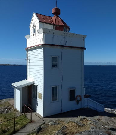
Ryvarden Light, Sveio, April 2018
ex-Google Plus photo by Mark Wallace

Sveio Lighthouses
** Ryvarden
1849. Active; focal plane 22 m (72 ft); white, red or green light, depending on direction, occulting three times every 10 s. 7 m (23 ft) square cylindrical wood tower with lantern and gallery. Lighthouse painted white, lantern roof red. Principal keeper's house (1935), assistant keeper's house (1958), boathouse, and other buildings. Mark Wallace's photo is at the top of this page, Trabas has a closeup by Wöhrn, the Anke/Jens site also has photos, Andreas Wallin has a 2019 photo, Ronny Aron Kopperdal has a street view, and Google has a satellite view. This lighthouse marks the southern entrance to the Bømlafjord and a network of passages leading far inland. The station has been converted to a regional cultural center including an art gallery and café; overnight accommodations are also available. However, the entrance to the lighthouse may be gated, so visitors must be prepared to hike 2 km (1.2 mi) or call for special permission to bring their cars to the site. Located about 8 km (5 mi) west of Sveio and 3 km (2 mi) off the pavement of highway 541. Accessible by road; some parking provided. Site open; gallery and other facilities open daily except Mondays from early July through mid August and on Sundays from Easter through Christmas. Site manager: Sveio Kommune (Ryvarden Kulturfyr ). ARLHS NOR-038; NF-133200; Admiralty B3578; NGA 2900.
Håskru
Date unknown. Active; focal plane 12 m (39 ft); white, red or green light, depending on direction, 1 s on, 1 s off. 6.5 m (21 ft) lantern on a square platform supported by piles. Lantern painted white with a red roof, piles painted black. Trabas has Boucher's photo (also seen at right) and Bing has a satellite view. Located on a skerry on the south side of the entrance to the Bømlafjord. Accessible only by boat. Site open, tower closed. NF-133400; Admiralty B3580; ex-NGA 2908.
Nappholmen
Date unknown. Active; focal plane 14.5 m (48 ft); white, red or green light, depending on direction, occulting twice every 8 s. 4 m (13 ft) lantern mounted on a rubblestone base. Lantern painted white with a red roof. Trabas has Boucher's photo and Bing has a satellite view. Located on a skerry on the south side of the Bømlafjord. Accessible only by boat. Site open, tower closed. NF-134500; Admiralty B3590; ex-NGA 2928.
Førdespollen
Date unknown. Active; focal plane 5 m (16 ft); white, red or green light, depending on direction, occulting once every 6 s. 6 m (20 ft) concrete post with lantern and gallery. Lighthouse painted white, lantern roof red. No photo available but Bing has a satellite view. Located on the west side of the Førdespollen, an inlet on the south side of the Bømlafjorden, about 3 km (2 mi) northwest of Førde. Accessible only by boat. Site and tower closed. NF-140000; Admiralty B3636; ex-NGA 2940.

Etne Lighthouses
Skånevik
Date unknown. Active; focal plane 5 m (17 ft); white, red, or green light depending on direction, 1 s on, 1 s off. 9 m (30 ft) concrete post with lantern and gallery. Lighthouse painted white, lantern roof red. No photo available but Bing has a distant satellite view. Located in the entrance to the inlet of the Skåneviksfjord leading to Skånevik. Accessible only by boat. Site open, tower closed. NF-141400; Admiralty B3656; ex-NGA 3060.

Håskru Light, Sveio, September 2011
photo copyright Michael Boucher; used by permission
Mosnes
Date unknown. Active; focal plane 6 m (20 ft); white or red light depending on direction, occulting once every 6 s. 6 m (20 ft) square tower with lantern and gallery. Lighthouse painted white, lantern roof red. Trabas has a photo by Günther Hess and Google has a distant satellite view. Located at the village of Mosnes on the north side of the upper Åkrafjord. Site status unknown. NF-141800; Admiralty B3662; ex-NGA 3072.

Eastern Kvinnherad Lighthouses
Hågarnsnes
Date unknown. Active; focal plane 6 m (20 ft); white, red, or green light depending on direction, 2 s on, 2 s off. 6 m (20 ft) concrete post with lantern and gallery. Lighthouse painted white, lantern roof red. Trabas has Wöhrn's distant view from the fjord and Google has a satellite view. Located on the tip of a promontory on the south side of the Husnesfjord in Husnes. Site status unknown. NF-142800; Admiralty B3671; ex-NGA 3088.
Ænes
Date unknown. Active; focal plane 12 m (39 ft); white, red, or green light depending on direction, occulting twice every 8 s. 6 m (20 ft) square tower with lantern and gallery. Lighthouse painted white, lantern roof painted red, tower painted black. Trabas has Wöhrn's distant view from the fjord but the tower is hard to see in Google's satellite view. Located on a headland on the east side of the Hardangerfjord (here also called the Sildafjord) at the entrance to the Maurangfjord. Site status unknown. NF-143700; Admiralty B3678; ex-NGA 3104.

Jondal Lighthouse
Hamaren (Hammaren)
Date unknown. Active; focal plane 18.5 m (60 ft); white, red, or green light depending on direction, occulting three times every 10 s. 6 m (20 ft) octagonal lantern mounted on a stone base. Lantern painted white, lantern roof red. Trabas has Wöhrn's view from the fjord and Google has an indistinct satellite view. Located on a promontory on the east side of the Hardangerfjord in southern Jondal. Site status unknown. NF-143800; Admiralty B3680; ex-NGA 3108.
Jonanes
Date unknown. Active; focal plane 8 m (26 ft); white, red, or green light depending on direction, occulting twice every 8 s. 8 m (26 ft) square tower with lantern and gallery. Lighthouse painted white, lantern roof red. A photo by Stefan Kontradowitz is at right, Trabas has Siering's photo, a view from the fjord is available, and Google has a distant satellite view. Located at the tip of a promontory on the east side of the Hardangerfjord about 3.2 km (2 mi) northwest of Jondal. Accessible only by boat, but there's a view from ferries crossing the fjord from Jondal to Tørvikbygd. NF-144000; Admiralty B3686; ex-NGA 3116.

Granvin Lighthouse
Håstabbenes
Date unknown. Active; focal plane 11 m (36 ft); white, red, or green light depending on direction, occulting twice every 8 s. 6 m (20 ft) square tower with lantern and gallery. Lighthouse painted white, lantern roof red. Trabas has Wöhrn's distant view from the fjord and Google has a satellite view. Located on the north side of the Hardangerfjord at the entrance to the Granvinsfjord. Site status unknown. NF-144400; Admiralty B3690; ex-NGA 3124.
Jonanes Light
Jonanes Light, Jondal, August 2011
photo copyright Stefan Kontradowitz; used by permission

Kvam Lighthouses
Ljonestangen
Date unknown. Active; focal plane 5 m (17 ft); white, red, or green light depending on direction, occulting once every 6 s. 5 m (17 ft) octagonal lantern mounted on a round stone base. Lantern painted white, lantern roof red. Trabas has Wöhrn's view from the fjord and Google has a satellite view. Located on the tip of a promontory on the west side of the Husnesfjord in Tangen. Site status unknown. NF-143900; Admiralty B3684; ex-NGA 3112.

Western Kvinnherad Lighthouses
Fjæreflu
Date unknown. Active; focal plane 7.5 m (25 ft); white, red, or green light depending on direction, occulting three times every 10 s. 8 m (26 ft) concrete post with lantern and gallery. Lighthouse painted white, lantern roof red. Trabas has Wöhrn's view and Google has a satellite view. Located on the west side of the Hardangerfjord (here also called the Kvinnheradsfjord) at the eastern entrance to the Øynefjord. Accessible only by boat. Site open, tower closed. NF-143300; Admiralty B3674; ex-NGA 3096.
Hamarhaugflu
Date unknown. Active; focal plane 5 m (17 ft); white, red, or green light depending on direction, occulting twice every 8 s. 9 m (30 ft) lantern supported by tripod piles. Lantern painted white, lantern roof red. No photo available but Google has a satellite view. Located at the southern end of the Lokksund, a narrow channel connecting the Hardangerfjord and the Bjørnafjord along the west side of Tysnesøy. Accessible only by boat. Site open, tower closed. NF-145200; Admiralty B3704; ex-NGA 3144.

Stord Lighthouses
Stord is a substantial island on the north side of the lower Hardangerfjord; the municipality of Stord occupies the southern portion of the island. Leirvik, at the south end of Stord, is a town with a population of about 14,000.
Leirvik Hamn (Husøysnaget) (?)
Date unknown. Replaced in 2015. This was a 7.5 m (25 ft) lantern supported by tripod piles. Lantern painted white with a red roof, piles painted black. Trabas has Boucher's photo. The light was replaced by a modern post light (focal plane 6 m (20 ft); white light, 1 s on, 1 s off). Google has an indistinct satellite view. Located on a reef in the harbor of Leirvik. Accessible only by boat. Site open, tower closed. ex-NF-148200; ex-Admiralty B3722; ex-NGA 3172. Active light: NF-148206.
** [Leirvik (1)]
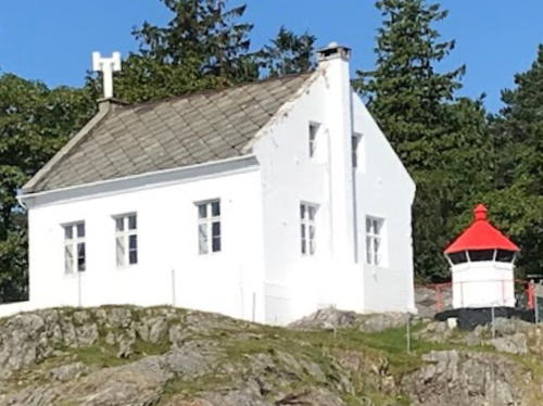
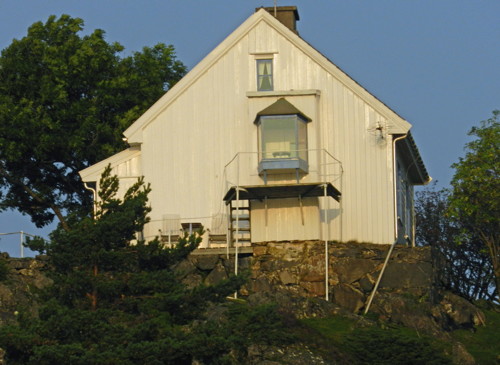
1878. Inactive since 1903. 1-1/2 story wood keeper's house. The former lantern has been removed. Sæbjørn Gravdal has the 2022 photo at right, Trabas has Wöhrn's view, Rolf Johansen has a 2018 photo, and Google has a satellite view. Although the lightkeepers were withdrawn in 1903, the station was revived as a manned fog signal station from 1930 to 1977. Stord Kommune bought the property of this station from the Kystverket in 2006 and plans to develop it as a public recreation area. A friends group was organized and a planning meeting was held in November 2011. The town extended utilities to the station and volunteers worked to restore the property. Accommodations are now available. Located on a promontory on the north side of the entrance to the harbor of Stord from the Husnesfjorden (a section of the Hardangerfjorden), about 3 km (2 mi) east of Stord. Site open, tower closed. Owner/site manager: Stord Kommune (Leirvik Fyrstasjon ).
* Leirvik (2)
1903 (station established 1878). Active; focal plane 14 m (46 ft); white, red or green light, depending on direction, occulting once every 6 s. Octagonal lantern mounted on a concrete pad. Located in front of the historic lighthouse. Site open, tower closed. Site manager: Stord Kommune. NF-148000; Admiralty B3720; ex-NGA 3168.

Leirvik Light, Stord, August 2022
Google Maps photo by Sæbjørn Gravdal
Stokkbleikjene
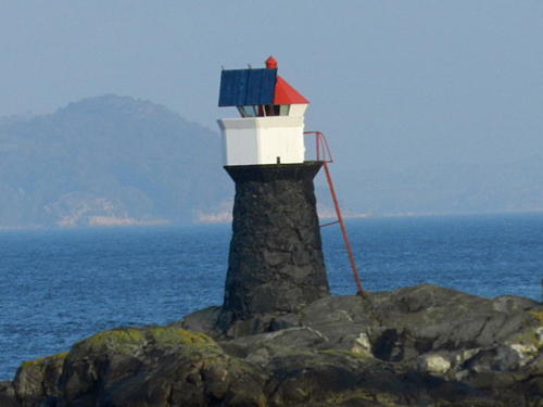
1918. Active; focal plane 8 m (26 ft); white, red or green light, depending on direction, 2 s on 2 s off. 7 m (23 ft) rubblestone cairn with lantern and gallery. Lantern painted white with a red roof; the tower is unpainted. Trabas has Boucher's closeup photo (also seen at right), a 2018 photo is available, and Google has an indistinct satellite view. Located on a skerry off a promontory on the southwest side of the island of Stord, marking a narrow passage between Stord and Bomlø. Accessible only by boat. Site open, tower closed. NF-150600; Admiralty B3740; ex-NGA 3264.

North Bømlo and Fitjar Lighthouses
Bømlo is a large island on the north side of the entrance to the Hardangerfjord. It is really two islands joined by a narrow isthmus that has been cut by a canal. North Bømlo faces east on the inside passage, while South Bømlo faces south on the lower Hardangerfjord and west on the North Sea. The lights of this section, along with the Stokkbleikjene Light listed just above, mark the narrow channel of the inside passage between Bømlo, Stord, and smaller islands to the north.

Osparøy
Date unknown. Active; focal plane 8.5 m (28 ft); white, red or green light, depending on direction, 1 s on, 1 s off. 6 m (20 ft) concrete post with lantern and gallery. Lighthouse painted white, lantern roof red. Trabas has Boucher's photo and Google has an indistinct satellite view. Located on an island off Robbestadneset, on the east coast of Bømlo. Accessible only by boat. Site open, tower closed. NF-150700; Admiralty B3741; ex-NGA 3288.
Brømenholmflu
Date unknown. Active; focal plane 6 m (20 ft); white, red or green light, depending on direction, occulting once every 6 s. 7.5 m (25 ft) lantern supported by tripod piles. Lantern painted white with a red roof, piles painted black. Trabas has Boucher's photo and Google has an indistinct satellite view. Located on the west side of the channel about 3 km (2 mi) north of Robbestadneset. Accessible only by boat. Site open, tower closed. NF-151000; Admiralty B3743; ex-NGA 3296.

Stokkbleikjene Light, Stord
photo copyright Michael Boucher; used by permission
Ringholmen (1)
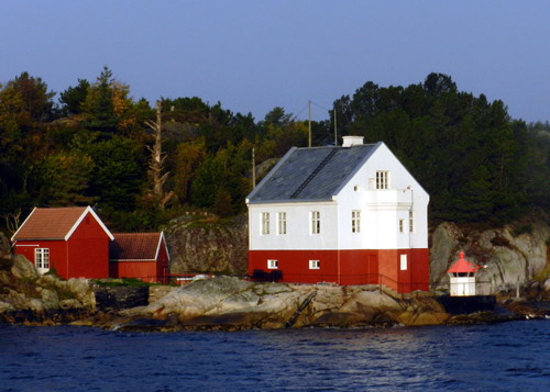
1876. Inactive since 1918. 10 m (33 ft) hexagonal cylindrical tower attached to one end of a 2-1/2 story keeper's house. Lantern removed. The house has been a private residence since shortly after its deactivation. The active light (focal plane 3 m (10 ft); white, red or green light, depending on direction, occulting twice every 8 s) is in a small lantern in front of the historic lighthouse. Trabas has Boucher's photo (also seen at right), Geir Braathen has a photo, and Google has an indistinct satellite view. The house is a private residence. Note: There is another Ringholmen light in Meland (see below). Located on a small island in the Nyleia channel northeast of Bomlø. Accessible only by boat. Site and tower closed. Site manager: private. Active light: NF-151200; Admiralty B3744; ex-NGA 3300.

South and West Bømlo Lighthouses
Langevåg (3?)
Date unknown (station established 1855). Inactive, apparently since 2020. 4 m (13 ft) lantern mounted on a concrete pad. Trabas has Boucher's distant view from the sea and Google has a satellite view. The original lighthouse was deactivated in 1896. It was built on a small island, but the island is now connected to the mainland by a breakwater. The light was replaced by a post light (continuous red light) called Litla Bleikja and located just offshore. We don't know if the original lantern was removed. Located on the south side of the entrance to Langevåg. Site status unknown but there's a view from ferries crossing the Bømlafjord from Langevåg to Buavåg. ex-NF-134000; ex-Admiralty B3586; ex-NGA 2924. Litla Bleikja Light: NF-134018; Admiralty B3586.1.
Bømlahamn
Date unknown. Active; focal plane 9 m (30 ft); white, red or green light, depending on direction, occulting three times every 10 s. 6 m (20 ft) concrete post with lantern and gallery. Lighthouse painted white, lantern roof red. Trabas has Boucher's view and Google has an indistinct satellite view. Located on the east side of the entrance from the Bømlafjorden to Bømlahamn, at the south end of Midtøy. Site status unknown. NF-133800; Admiralty B3585; ex-NGA 2912.
Ringholmen Fyr
Ringholmen Light, Bomlø, September 2011
photo copyright Michael Boucher; used by permission
Raudholmene
Date unknown. Active; focal plane 18 m (59 ft); one long flash, white, red or green depending on direction, every 10 s. 8.5 m (28 ft) lantern on a square platform supported by piles. Lantern painted white with a red roof, piles painted black. Arild Barane has a 2021 view, Trabas has Boucher's very distant view, and Google has a satellite view. Located on a small island in the center of the entrance to the Bømlafjord. Accessible only by boat. Site open, tower closed. NF-133500; Admiralty B3584; ex-NGA 2932.
[Espevær]
1849. Inactive since 1913. 1-1/2 story wood keeper's house. The ground-level lantern has been removed. No current photo available but there's a historic photo and Bing has a satellite view. The building has been a private residence for many years. The modern Saugøybaen beacon (NF-135001) is just offshore. Located at the southern tip of Espevær, an island off the southwestern tip of Bomlø. Site status unknown.
Lyngøyosen
Date unknown. Active; focal plane 10.5 m (34 ft); white, red or green light depending on direction, 1 s on, 1 s off. 5.5 m (18 ft) concrete post with lantern and gallery. Lighthouse painted white, lantern roof red. No photo available but Google has a satellite view. Located at the southeastern tip of an island off the central west coast of Bømlo. Accessible only by boat. Site open, tower closed. NF-135501; Admiralty B3610; ex-NGA 2960.
Skotningen
Date unknown. Active; focal plane 43 m (141 ft); flash every 5 s, white, red or green depending on direction. 9.5 m (31 ft) square tower with lantern and gallery. Lighthouse painted white, lantern roof painted red, tower painted black. Terje Nordtun has a very distant view and Google has a satellite view. Located on an island off the west coast of Bømlo, about 3 km (2 mi) northwest of the Lyngøyosen light. Accessible only by boat. Site open, tower closed. NF-135600; Admiralty B3612; ex-NGA 2964.
Hisken
Date unknown. Active; focal plane 19 m (62 ft); white, red or green light depending on direction, 3 s on, 3 s off. 5 m (17 ft) lantern mounted on a stone base. Lantern painted white with a red roof. No photo available but Google has a satellite view. Located on a small island on the north side of the entrance to the fjord leading to Vordnes. Accessible only by boat. Site open, tower closed. NF-135700; Admiralty B3614; ex-NGA 2968.

Northwest Bømlo and Slåtterøy Lighthouses
Aksteinen
Date unknown. Active; focal plane 16.5 m (54 ft); white, red or green light depending on direction, 2 s on, 2 s off. 6.5 m (21 ft) lantern mounted on a stone cairn. Lantern painted white with a red roof, cairn black. Geir Ove Sørvik has the view from a neighboring island, Åsmund Nesse has a distant photo, and Google has a satellite view. Located off the northwest coast of Bømlo. Accessible only by boat. Site open, tower closed. NF-138800; Admiralty B3626; ex-NGA 2992.
Jarnnagleholmen
Date unknown. Active; focal plane 15 m (49 ft); white, red or green light depending on direction, 2 s on, 2 s off. 9 m (30 ft) concrete post with lantern and gallery. Lighthouse painted white, lantern roof painted red. Geir Ove Sørvik has a stormy view from the sea and Google has a satellite view. Located on an islet off the south coast of Gisøy, an island at the northwestern corner of Bomlø. Accessible only by boat. Site open, tower closed. NF-153400; Admiralty B3751; ex-NGA 3380.
* Slåtterøy
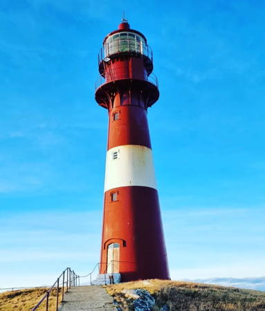
1859. Active; focal plane 46 m (151 ft); two white flashes every 30 s. 25 m (82 ft) round cast iron tower with lantern and double gallery, painted red with one white horizontal band. 2-story wood principal keeper's house and numerous other light station buildings. A 2022 photo is at right, Trabas has a photo by Wöhrn, Svein Konrad Sjursen has a photo, Geir Johannessen has a 2019 photo, Wikimedia has a 2013 photo, and Google has a satellite view. This historic and beautiful lighthouse was staffed until 2003. It was then transferred to Bømlo Kommune, which organized the Friends of Slåtterøy Lighthouse to manage the station under a lease from the Kystverket. Overnight accommodations are available and guided tours of the lighthouse can be arranged. Located on a small island just off the larger island of Gisøy, marking the south side of the entrance to the Selbjørnsfjord. Accessible only by boat; there should be distant views from Gisøy, which is accessible at the end of highway 18 about 8 km (5 mi) northwest of Bømlo. Site open, tower open to guided tours by reservation. Site manager: Bømlo Kommune (Slåtterøy Fyr ). ARLHS NOR-216; NF-153500; Admiralty B3752; ex-NGA 3384.
Stålhuva (Stålhovo)
Date unknown. Active; focal plane 15 m (49 ft); white, red or green light depending on direction, 3 s on, 3 s off. 9 m (30 ft) concrete post with lantern and double gallery. Lighthouse painted white, lantern roof painted red. Geir Ove Sørvik has a closeup photo, Toralv Martin has a distant view, and Google has an indistinct satellite view. Located on an islet about 1.5 km (1 mi) east of the Slåtterøy lighthouse. Accessible only by boat. Site open, tower closed. NF-153600; Admiralty B3753; NGA 3408.

Slåtterøy Light, Bømlo, January 2022
Google Maps photo by Charlotte

Austevoll Lighthouses
The Austevoll municipality is an archipelago of 667 islands separated from the mainland by the Bjørnafjord. There are several fishing villages with a total population of about 5200.
Økshammaren (Økshamaren) (3)
1918 (station established 1849). Active; focal plane 22 m (72 ft); white, red or green light, depending on direction, occulting twice every 8 s. 4 m (13 ft) octagonal lantern mounted on a concrete pad at the top of a near-vertical cliff. Trabas has Boucher's photo and Google has a satellite view. Located about 80 m (90 yd) northeast of the historic lighthouse. Site and tower closed. NF-156400; Admiralty B3760; ex-NGA 3448.
Økshammaren (Økshamaren) (2)
1875 (station established 1849). Inactive since 1918. Square lantern mounted on the seaward end of a 1-1/2 story wood keeper's house. House painted white. Michael Boucher contributed the photo at right, Odd Haldorsen has a closeup photo, and Google has a satellite view. This is what was called a "fishing light" because it was operated only during the local fishing season. After deactivation the house was sold as a private residence. Located at the eastern tip of the island of Selbjørn, across the Selbjørnsfjord from Slåtterøy lighthouse. Site and tower closed. Site manager: private. ARLHS NOR-286.
Stallaren (Stallareskjer)
Date unknown. Active; focal plane 9 m (30 ft); white, red or green light, depending on direction, 3 s on, 3 s off. 6.5 m (21 ft) lantern and gallery mounted on tripod piles. Lantern painted white with a red roof. No photo available but Google has a satellite view. Located on a small island in the Mokstrafjord northwest of Selbjørn. Accessible only by boat. Site open, tower closed. NF-157400; Admiralty B3767; ex-NGA 3420.
Økshammaren Fyr
1875 Økshammaren Light, September 2011
photo copyright Michael Boucher; used by permission
Rosmunnholmen
Date unknown. Active; focal plane 24 m (79 ft); white, red or green light, depending on direction, 1 s on, 1 s off. 6 m (20 ft) square tower with lantern and gallery. Lighthouse painted white, lantern roof red. No photo available but Google has a satellite view. Located on a small island in the Mokstrafjord north of Selbjørn. Accessible only by boat. Site open, tower closed. NF-157600; Admiralty B3766.8; ex-NGA 3432.
Pirholmen (1)
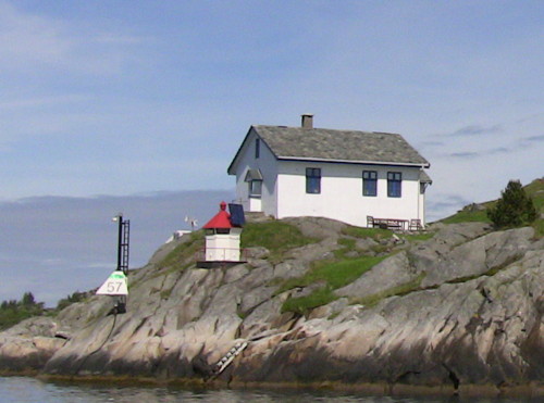
1849. Inactive since 1900. Lantern window on the front of a 1-1/2 story concrete keeper's house. A photo is at right, Trabas has Boucher's photo and Google has a satellite view. The active light (focal plane 7 m (23 ft); white, red or green light, depending on direction, 1 s on, 1 s off) is in a small lantern close to the historic lighthouse. Also seen in the photo at right is a post that carries a continuous green passing light (NF-156757).The house has been a private residence since 1903. Located on an island in the Bekkjarviksund about 2 km (1.2 mi) southeast of Austevoll. Accessible only by boat. Site and tower closed. Active light: NF-156700; Admiralty B3764; ex-NGA 3488.
Rostøy
Date unknown. Active; focal plane 10 m (33 ft); white, red or green light depending on direction, 3 s on, 3 s off. 5 m (17 ft) concrete post with lantern and gallery. Lighthouse painted white, lantern roof painted red. No photo available but Google has a dark satellite view. Located on the northern tip of Rostøy, about 1.5 km (1 mi) east of the Pirholmen lighthouse. Accessible only by boat. Site open, tower closed. NF-156800; Admiralty B3764.4; ex-NGA 3480.
Kassholmboen
Date unknown. Active; focal plane 6 m (20 ft); white, red or green light, depending on direction, 1 s on, 1 s off. 6 m (20 ft) octagonal lantern, painted white with a red roof, mounted on tripod piles. Google has a distant street view from the Bakkasund Bridge and a distant satellite view. Located in the Horgesund off Bakkasund on the island of Store Kalsøy, on the south side of the Korsfjord. Accessible only by boat. Site status unknown. NF-158600; Admiralty B3774; NGA 3508.
Pirholmen Light
Pirholmen Light, Austevoll, May 2009
ex-Panoramio Creative Commons photo by trolvag
Bakkasund
Date unknown. Active; focal plane 9 m (30 ft); white, red or green light, depending on direction, 3 s on, 3 s off. 4 m (13 ft) lantern, white with a red roof. Google has a distant street view from the Bakkasund Bridge and a distant satellite view. Located on a forested point just north of the bridge. Accessible only by boat. Site status unknown. NF-158700; Admiralty B3776; NGA 3512.
#Lindholmen
Date unknown. Inactive since 2015(?) and later removed. 8 m (26 ft) lantern mounted on tripod piles. Lantern painted white with a red roof, tripod painted black. Trabas has Boucher's photo but Google's satellite view confirms the removal. The light was replaced with a light on a post (focal plane 7.5 m (25 ft); continuous red light). Located on a reef off the northern end of Huftarøy. Accessible only by boat, but there's a good view from ferries between Hufthamar and the mainland. Site open, tower closed. ex-NF-157200; ex-Admiralty B3766.2; NGA 3484. Active light: NF-157284.
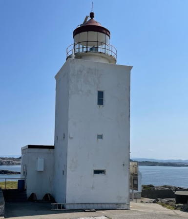
** Marstein
1877. Active; focal plane 38 m (125 ft); white or red light, depending on direction, 2 s on, 2 s off. 17 m (56 ft) square cylindrical masonry tower with lantern and gallery, attached to a 1-story service building. Lighthouse painted white; lantern roof painted red. 1-story keeper's house in poor condition. Jon Erling Johnsen's 2021 photo is at right, Jan-Eirik Nilsskog has a fine closeup, Audun Stølås has another closeup, Wikimedia has a 2013 photo, Trabas has Helmut Seger's view from the fjord, and Google has a satellite view. Automated in 2002, the station was damaged by a severe storm in 2005. The repaired station was transferred to Austevoll Kommune in 2006. After restoration of the keeper's house the station was opened for tours and overnight stays in 2010. Since 2013 the Kommune has leased the station to a hotel in Bergen. Overnight accommodations are available and there are also guided tours in season. Located on a small island on the south side of the entrance to the Korsfjord. This is the route to Bergen for larger vessels, so there should be a view of the lighthouse from North Sea ferries bound for that city. Accessible only by boat or helicopter. Site and tower open to guided tours. Owner: Austevoll Kommune. Site manager: Panorama Hotell & Resort (Marstein Fyr ). ARLHS NOR-031; NF-159000; Admiralty B3780; NGA 3520.
Skjeljaboskaget
Date unknown. Active; focal plane 17 m (56 ft); one long flash every 10 s, white, red or green, depending on direction. 6 m (20 ft) lantern mounted on a platform supported by four piles. Lantern painted white with a red roof. Trabas has Helmut Seger's view from the fjord and Google has a satellite view. Located at the northwestern corner of Store Kalsøy. Site status unknown. NF-159200; Admiralty B3782; NGA 3524.
Litle Laugarøy
Date unknown. Active; focal plane 16 m (52 ft); white, red or green light, 3 s on, 3 s off. 5 m (17 ft) square tower with lantern and gallery. Lighthouse painted white; lantern roof is red. No photo available but Google has a satellite view. Located on a small island on the west side of the entrance to the Bjørnafjord. Accessible only by boat. Site open, tower closed. NF-149900; Admiralty B3736; NGA 3232.

Marstein Light, Austevoll, July 2021
Google Maps photo by Jon Erling Johnsen

Tysnes Lighthouse
Presteskjær
Date unknown. Active; focal plane 6 m (20 ft); white, red or green light, depending on direction, occulting three times every 10 s. 6 m (20 ft) square tower with lantern and gallery. Lighthouse painted white; lantern roof is red. No photo available but Google has a satellite view. Located on an islet about 1 km (0.6 mi) northeast of the ferry terminal at Våge on the north side of Tysnesøy. Accessible only by boat. Site open, tower closed. NF-147500; Admiralty B3716; ex-NGA 3164.

Fusa Lighthouse
* Venjaneset (Vengjaneset, Venganeset)
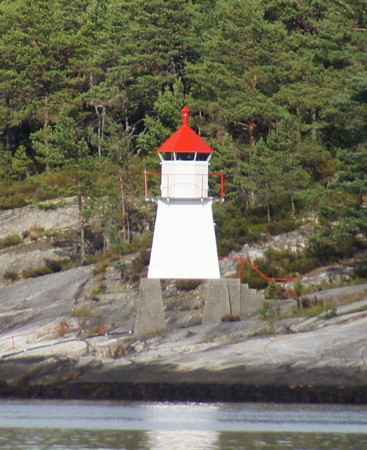
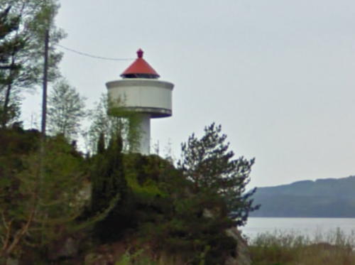
Date unknown. Active; focal plane 10.5 m (34 ft); white, red or green light, depending on direction, occulting once every 6 s. 6 m (20 ft) concrete post with lantern and gallery. Lighthouse painted white; lantern roof is red. Google has a 2009 street view (a portion is seen at right) and a satellite view. A 2023 street view shows trees that grown beside the light. Located at the Venjaneset ferry terminal on the south side of the Fusafjord. Site open, tower closed. NF-146200; Admiralty B3711; ex-NGA 3236.

Os Lighthouse
Bleikja
Date unknown. Active; focal plane 5 m (17 ft); white, red or green light, depending on direction, 1 s on, 1 s off. 6 m (20 ft) concrete post with fiberglass lantern and gallery. Lighthouse painted white; lantern roof is red. Trabas has a closeup photo by Wöhrn, Roald Atle Furre has a nice view from the fjord, and Google has a satellite view. Located on an island in the the Bjørnafjord on the east side of the entrance to the harbor of Haljem. Accessible only by boat. Site and tower closed (private property). ARLHS NOR-397; NF-149700; Admiralty B3735; ex-NGA 3228.

Venjaneset Light, Fusa, April 2009
Google Maps street view

Information available on lost lighthouses:

Notable faux lighthouses:

Adjoining pages: South: Haugesund Area | North: Bergen Area

Return to the Lighthouse Directory index | Ratings key

Posted June 19, 2006. Checked and revised June 27, 2024. Lighthouses: 47. Site copyright 2024 Russ Rowlett and the University of North Carolina at Chapel Hill.