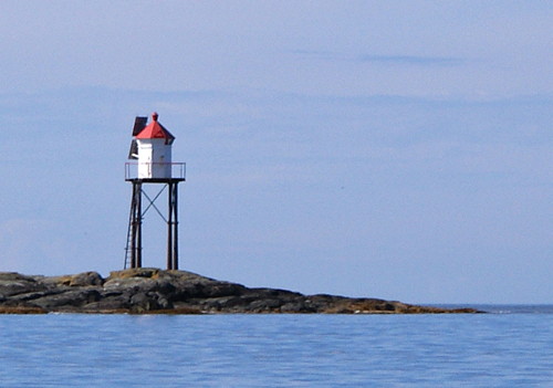
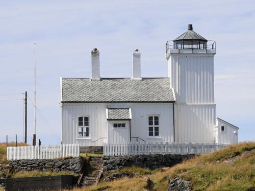
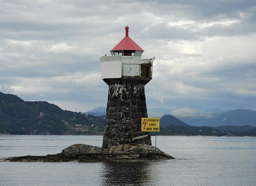
Lighthouses of Norway: Haugesund Area (Northern Rogaland)

The Kingdom of Norway (Norge in Norwegian) is one of the world's most maritime nations. The country is long and narrow with drowned valleys called fjords that bring the sea far inland in most regions. The mainland coast is estimated to be 2650 km (1650 mi) long and when all the islands and minor indentations are counted the total coastline approaches an astonishing 60,000 km (37,500 mi), long enough the go around the world one and a half times. With such a lengthy and rocky shore it's not surprising that Norway has a large number of lighthouses.

Norway is divided into counties (fylker) and the counties are divided into townships (kommuner). This page lists lighthouses of the Karmøy and Haugesund area in northern Rogaland County on the southwest coast of Norway. Lighthouses of the central part of Rogaland are on the Stavanger Area page, and those of the southern area are on the Eigersund Area page.

In Norwegian a lighthouse is a fyrtårn (fire tower) or simply a fyr; a fyrlykt is a beacon and a lyktehus is a lantern. Øy is an island, holmen is an islet, skjær is a skerry (a tiny island or rocky reef), sund is a strait (often between an island and the mainland), bukt is a bay, nes is a headland, and havn is a harbor.

Aids to navigation are maintained by the Kystverket (Coast Directorate), an agency of the Ministry of Transport and Communications.

ARLHS numbers are from the ARLHS World List of Lights. NF numbers are from the Norsk Fyrliste. Admiralty numbers are from volume B of the Admiralty List of Lights & Fog Signals. U.S. NGA List numbers are from Publication 115. In 2018 NGA dropped most of its listings for the Norwegian fjords.

General Sources
Online List of Lights - Norway - Southwest Coast
Photos by various photographers posted by Alexander Trabas; for this area many of the photos were taken by Ronald Wöhrn, Michael Boucher, or Sigurd Vermundsen.
Norwegian Lighthouse Association
News and photos from the Association.
Lighthouse Pages from Anke and Jens - Norway
Excellent photos of more than 60 Norwegian lighthouses.
Leuchttürme an der Norwegischen Küste
Photos posted by Bernd Claußen.
Lighthouses in Rogaland
Photos by various photographers available from Wikimedia.
World of Lighthouses - Norway
Photos by various photographers available from Lightphotos.net.
Norwegische Leuchttürme auf historischen Postkarten
Historic postcard images posted by Klaus Huelse.
Norsk Fyrliste
Current edition of the Norwegian light list.
Liste over Norske Fyr
From Norwegian Wikipedia, a handy list of Norwegian light stations with their dates of establishment.
GPSNauticalCharts
Navigational chart information for Rogaland.
Navionics Charts
Navigational chart for Rogaland.


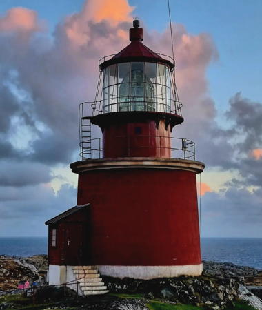
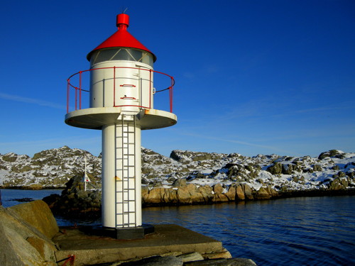
Utsira Light, Utsira, October 2023
Instagram photo by tormsk
Utsira Lighthouses

Utsira is an island about 2.5 km (1.5 mi) long and 1.2 km (3/4 mi) wide, located in the North Sea 18 km (11 mi) west southwest of Haugesund. Accessible by passenger ferries from Haugesund, the island is famous among birders as one of the best birding sites in northern Europe. The permanent population, barely 200, makes Utsira the least populous Norwegian township.

*
Utsira (south tower)
1844. Inactive since 1890. Approx. 9 m (30 ft) round stone tower, unpainted; lantern removed. Atle Grimsby has a photo, June Beathe Sola has a closeup 2022 street view, and Google has a street view and a satellite view. This is the only light station in Norway where twin lighthouses survive; two were built so that the two continuous lights could be distinguished from the single continuous light at Kvistøy. The second tower became redundant when effective flashing equipment came into use. Located about 100 m (330 ft) southeast of the north tower (next entry). ARLHS NOR-344.
* Utsira (north tower)
1844. Active; focal plane 78 m (256 ft); three white flashes every 60 s. 13 m (43 ft) round stone tower with lantern and gallery, painted red with white trim. 1st order Fresnel lens in use. A 2023 photo is at the top of this page, Sten Ramsland has a 2021 photo, Karolina Alkemade has a 2023 photo, Eirik Newth has a photo, Trabas has a photo by Pauline and Wim de Kleine, Atle Grimsby has a good 2010 photo, and Google has a street view and a satellite view. Several 1-story keeper's houses are available for overnight accommodations . The lighthouses are located at the west end of the island. Site open, tower closed. ARLHS NOR-262; NF-129500; Admiralty B3540; NGA 2812.
* Nordvikvågen (Nordevågen) Breakwater
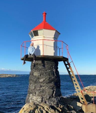
Date unknown. Active; focal plane 7 m (23 ft); white, red or green light, depending on direction, occulting once every 6 s. 5 m (17 ft) concrete post with a round lantern and gallery. Lighthouse painted white; lantern roof is red. Atle Grimsby's photo is at right, a distant view is available, and Google has a street view and a distant satellite view. Located at the end of the breakwater for the Nordvikvågen harbor on Utsira's north coast. Accessible by walking the breakwater. NF-129600; Admiralty B3541; ex-NGA 2816.
Beiningskalven
Date unknown. Active; focal plane 12 m (39 ft); flash every 3 s, white or red depending on direction. 4 m (13 ft) octagonal lantern with gallery mounted directly on a concrete base. Lantern and gallery painted white, lantern roof red, concrete base black. Trabas has a very distant view, and Google has a satellite view. Located atop Beiningskalven, an islet off the east coast of Beiningen, an inhabited island about 600 m (3/8 mi) south of Utsira's main waterfront on the south coast of the island. Accessible only by boat. Site and tower closed. NF-129900; Admiralty B3544; ex-NGA 2824.
Vindballen (2)
Date unknown. Active; focal plane 15 m (49 ft); white, red or green light, depending on direction, 2 s on , 2 s off. 10 m (33 ft) fiberglass tower colored white with two black horizontal bands. Alan Billyeald has a 2023 drone view and Google has a distant satellite view. Trabas has a very distant view of the earlier light, a concrete post with lantern and gallery. Located on a rocky islet off the south coast of Utsira. Accessible only by boat. Site and tower closed. ARLHS NOR-277; NF-129800; Admiralty B3541.4; ex-NGA 2820.

Nordvikvågen Breakwater Light, Utsira, February 2010
Flickr Creative Commons photo by Atle Grimsby

Karmøy Lighthouses

Karmøy is the name of a large island northwest of Stavanger and also of a municipality that includes the island and a portion of the mainland. The west coast of the island faces directly on the Atlantic Ocean, while the east side is separated from the mainland and the islands of Bokn by the Karmsund, the southernmost link in Norway's inside passage. The island is accessible by ferries from Stavanger and by a bridge on highway 47 at Salhus near the northern end.

Karmsund Lighthouses
Smørstakk
Date unknown. Active; focal plane 12.5 m (41 ft); white, red or green light, depending on direction, 2 s on, 2 s off. 10.5 m (34 ft) concrete post with lantern and gallery. Lighthouse painted white, lantern roof red. No photo available but Google has a satellite view. Located on an island on the east side of the Karmsund about 5 km (3 mi) southeast of Kopervik. Accessible only by boat. Site open, tower closed. NF-120400; Admiralty B3428; ex-NGA 2604.
Kopervik (Kobbernaglen)
Date unknown (station established 1863). Active; focal plane 8 m (26 ft); white, red or green light, depending on direction, occulting twice every 8 s. 8 m (26 ft) round solid stone tower with lantern and gallery. Lantern painted white with a red roof; the supporting tower is painted with black and white vertical stripes. Trabas has Boucher's photo and Google has a satellite view. Located on a rocky reef in the entrance to the harbor of Kopervik. Accessible only by boat. Site open, tower closed. ARLHS NOR-140; NF-120500; Admiralty B3430; ex-NGA 2620.
Dua
Date unknown. Active; focal plane 5 m (17 ft); white, red or green light, depending on direction, occulting once every 6 s. 6 m (20 ft) concrete post with lantern and gallery. Lighthouse painted white, lantern roof red. Trabas has Boucher's photo and Google has a satellite view. Located on a skerry off the east side of the Karmsund northeast of Kopervik. Accessible only by boat. Site open, tower closed. NF-120800; Admiralty B3434; ex-NGA 2624.
Høgevarde (Høyevarde) (2)
1859 (station established 1700). Inactive since 1902. 14 m (46 ft) cylindrical tower attached to the seaward end of a 1-1/2 story keeper's house. Lantern removed. A boathouse and other station buildings also survive. Buildings painted white. A 2020 photo is at right, a 2007 photo is available, Wikimedia has Michael Spiller's view, and Google has a satellite view. After deactivation the station was sold. In 1963 Norsk Hydro bought the property and in 1975 the company restored the lighthouse as a guest house. The building is now leased to Lothes, a restaurant in Haugesund. It is available for overnight rental in July and as a location for parties and meetings the rest of the year. Located on a promontory at Avaldsnes on the east side of Karmøy (and the west side of the Karmsund, which separates Karmøy from the mainland). Site and tower closed. Owner: Hydro. Site manager: Lothes Mat & Vinhus. . ARLHS NOR-127.
Høgevarde (3) (?)
Date unknown. Inactive since 2015 and possibly removed. 4 m (13 ft) lantern mounted on an octagonal concrete base. Lantern painted white with a red roof, base painted black. Trabas has Boucher's photo and Google has a satellite view. This light is about 1.6 km (1 mi) north of the historic lighthouse. Located on a skerry in the middle of the Karmsund off Våge. Accessible only by boat. Site open, tower closed. ex-NF-120900; ex-Admiralty B3436; ex-NGA 2628.

Høgevarde Light, Karmøy, June 2020
Instagram photo by magne_otteraa
Snikspynten (2)
Date unknown. Active; focal plane 6.5 m (21 ft); white, red or green light, depending on direction, occulting twice every 8 s. 5 m (17 ft) round cylindrical fiberglass tower with lantern and gallery. The lighthouse is white, lantern roof red. Trabas has Boucher's photo and Google has a satellite view. This lighthouse replaced a simple post light. Located on the east side of the Karmsund at Snik. Accessible only by boat. Site open, tower closed. NF-121200; Admiralty B3438; ex-NGA 2636.
Bukkøya (2)
2019. Active; focal plane 14 m (46 ft); white, red or green light, depending on direction, occulting once every 6 s. 6.5 m (21 ft) fiberglass tower with lantern, colored white with two black horizontal bands; lantern roof is red. Google has a distant 2022 street view and a distant satellite view. Alf-Robert Sommerbakk has a closeup street view of the earlier tower and Trabas has Boucher's photo. NGA misspells the name "Bukoy." Located on the east end of Bukkøya, and island that nearly blocks the Karmsund across from Vormedal. Accessible only by boat. Site open, tower closed. NF-121300; Admiralty B3440; ex-NGA 2640.
#Salhus
Date unknown. Removed in 2018. This was a 4 m (13 ft) lantern mounted on an octagonal concrete base. Lantern painted white with a red roof, base painted black. Trabas has Boucher's photo and Google has a satellite view. Formerly located under the western end of the Karmsund Bridge. Site open, tower closed. ex-NF-121400; ex-Admiralty B3442; ex-NGA 2644.
 

Skudenes Light, Karmøy, May 2020
Instagram photo by Magne Otterå
 

Karmøy South Coast Lighthouses
* Skudenes (3)
Date unknown (station established 1799). Active; focal plane 22 m (72 ft); white, red or green light, depending on direction, occulting three times every 10 s. 4 m (13 ft) lantern and gallery mounted on a short stone base. Gallery painted white, lantern roof red. Magne Otterå's photo is above right, Trabas has Ronald Wöhrn's photo, Claußen has photos, a distant view is available, Alf-Robert Sommerbakk has a street view, and Google has a satellite view. A collection of keeper's houses and other building survive from the earlier lighthouse, which was deactivated in 1924 when the Geitungen lighthouse was inaugurated. These buildings are privately owned. Located on a promontory on the southeastern point of Karmøy and on the east side of the harbor of Skudeneshavn. Site status unknown, although it should be possible to view the buildings from nearby. There should also be a good view from ferries arriving in Skudeneshavn from Mekjarvik near Stavanger. . ARLHS NOR-212; NF-125400; Admiralty B3502; NGA 2700.
[Vikeholmen (Vikaholmen) (2)]
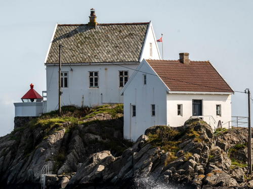
1875 (station established 1849). Inactive since 1908. Two 1-1/2 story keeper's houses, painted white. Presumably the lantern was formerly mounted on the higher and more seaward of the houses; the active light is in front of that house. Ellen May Nielsen's 2023 photo is at right, Trabas has Ronald Wöhrn's photo, a 2020 photo is available, Claußen has photos, a summer 2007 photo of the station is available, and Google has a satellite view. Originally the station had a small light tended as needed by local fishermen. The house was a private residence for many years, but recently it has been purchased by the Sailors Association and it is now available for overnight rental. Located on a small island about 800 m (1/2 mi) south of the harbor of Skudenshavn. Accessible only by boat (a boat is provided for renters). Site open, buildings open to paying guests only. There's a good view from ferries arriving from Mekjarvik near Stavanger. Site manager: Skudenes Sjømannsforening (Vikeholmen Fyr). . ARLHS NOR-275.

Vikeholmen Light, Karmøy, August 2023
Instagram photo by Ellen May Nielsen
Vikeholmen (Vikaholmen) (3)
Date unknown. Active; focal plane 8 m (28 ft); white, red or green light, depending on direction, occulting once every 6 s. Lantern and gallery mounted on a short stone base. Gallery painted white, lantern roof red. A photo is above right. Located immediately in front of the historic lighthouse. Site open, tower closed. ARLHS NOR-347; NF-125500; Admiralty B3503; NGA 2704.
Geitungen
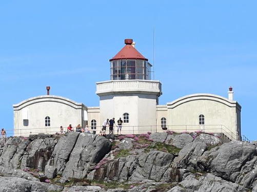
1924. Active; focal plane 41 m (135 ft); white, red or green light, depending on direction, occulting once every 6 s. 11 m (36 ft) octagonal cylindrical masonry tower, attached to a U-shaped 1-story keeper's house. Lighthouse painted white; lantern roof is red. Magne Otterå's 2020 photo is at right, another 2020 photo is available, Claußen has photos, Trabas has a photo by Pauline and Wim de Kleine, and Google has a satellite view. This lighthouse was built in response to complaints that the Kvitsøy lighthouse was too far east to provide an effective landfall light for Stavanger. The lighthouse was automated in 1994; since then it has been renovated and is available for overnight accommodations. Located on an island off the southern tip of Karmøy; the island is about 1 km (0.6 mi) offshore and 3 km (2 mi) southwest of the Skudeneshavn harbor entrance. Accessible only by boat; landing facilities and transportation for guests are available. Site open, lighthouse open only to paying guests or by special arrangement. Site manager: Haugesund Turistforening (Geitungen Fyr )ARLHS NOR-016; NF-126500; Admiralty B3514; NGA 2728.
Hekseterholmen (2)
1999 (station established 1925). Active; focal plane 9.5 m (31 ft); red or green light, depending on direction, 3 s on, 3 s off. 5.5 m (18 ft) concrete post with lantern and gallery. Lighthouse painted white, lantern roof red. No photo available but Google has a satellite view. The lantern of the original lighthouse is displayed at the Karmøy Fiskerimuseum in Vedavågen (see below). Located on a skerry about 1.2 km (3/4 mi) southeast of Syrevågen. Accessible only by boat. Site open, tower closed. NF-126700; Admiralty B3518; NGA 2736.
* Syrevågen
Date unknown. Active; focal plane 12 m (39 ft); white, red or green light, depending on direction, 1 s on, 1 s off. 8 m (26 ft) lantern and gallery on four cast iron straightpiles. Lantern painted white with a red roof; piles painted gray. Ingveig Aronsen has a lovely street view and Bing has a distant satellite view. Located at the end of the mole at Syrevågen, about 2 km (1.2 mi) west of Skudeneshavn. Site open, tower closed. NF-126600; Admiralty B3516; NGA 2732.

Geitungen Light, Karmøy, May 2020
Instagram photo by Magne Otterå
Jarsteinen (2)
2021(?). Active; focal plane 28 m (92 ft); white, red or green light, depending on direction, 2 s on, 2 s off. 6 m (20 ft) fiberglass tower with lantern, colored white with two black horizontal bands; lantern roof is red. Lighthouse painted white, lantern roof red. No photo available but Google has a satellite view. A 2020 drone view of the earlier light is available and Claußen has several photos. Located at the north end of an island off the southwestern tip of Karmøy. Accessible only by boat. Site status unknown. NF-126800; Admiralty B3520; NGA 2740.

West Coast Lighthouses
* Ferkingstadneset
Date unknown. Active; focal plane 20 m (66 ft); white, red or green light, depending on direction, occulting twice every 8 s. 9 m (30 ft) round cylindrical steel tower with lantern and gallery. Lighthouse painted white, lantern roof red. Trabas has Andreas Köhler's closeup photo, Svein Arild Aarskog has a photo, Tore Thorbjørnsen has a 2020 street view, and Bing has an indistinct satellite view. Near the lighthouse is a conical rubblestone monument to Norwegian sailors. Located on a promontory about 1 km (0.6 mi) southwest of Ferkingstad harbor. Site open, tower closed. NF-127500; Admiralty B3523; NGA 2756.
* Åkrehamn
Date unknown (station established 1895). Active; focal plane 8 m (26 ft); white, red or green light, depending on direction, occulting once every 6 s. 7 m (23 ft) octagonal lantern and gallery mounted on a round rubblestone base. The lantern is white with a red roof. Enija Eglīte's 2021 photo is at right, Trabas has Andreas Köhler's closeup photo, Daniel Øyan has a photo, Ingve Moss Liknes has a 2009 photo, and Bing has a satellite view. Located on the waterfront of Åkrehamn. Site open, tower closed. NF-127800; Admiralty B3525; ex-NGA 2784.
* Marøy
1890. Active; focal plane 12 m (39 ft); white, red or green light, depending on direction, occulting once every 6 s. 4 m (13 ft) octagonal lantern, painted white with a red roof, mounted on a stone pad. No photo available but Google has an indistinct satellite view. Located on the south tip of Marøy, an island about 1.5 km (1 mi) north of Åkrehamn, on the west coast of Karmøy. Site open, tower closed. NF-129000; Admiralty B3532; ex-NGA 2796.
* Hekseterholmen (1)
1925. Inactive since 1999. 4 m (13 ft) octagonal lantern, painted white with a red roof, mounted on a stone pad. Willy Haraldsen has a photo and Google has a street view and a satellite view. Formerly located on a promontory on the west side of the entrance to Skudeneshavn in southern Karmøy, this lantern is now displayed at the Karmøy Fiskerimuseum in Vedavågen. Site open, tower closed. Site manager: Karmøy Fiskerimuseum.
* Kalstø (Kallstø)
Date unknown. Active; focal plane 22 m (72 ft); white, red or green light, depending on direction, occulting three times every 10 s. Approx. 8 m (26 ft) square pyramidal tower with lantern and gallery. Tower painted white; lantern roof is red. No photo available but Google has a satellite view. Located on the west side of Karmøy about 5 km (3 mi) southwest of Visnes. Site status unknown. ARLHS NOR-447; NF-129200; Admiralty B3536; ex-NGA 2804.

Åkrehamn Light, Karmøy, December 2021
Google Maps photo by Enija Eglīte

Feøy Lighthouses
Feøy is a group of small islands about 5 km (3 mi) northwest of Visnes, Karmøy. The islands have a population of about 60 and are accessible by passenger ferry from Haugesund.

Flatmøy
Date unknown. Active; focal plane 9 m (30 ft); white, red or green light, 3 s on, 3 s off. 9 m (30 ft) lantern on a platform supported by four piles. Lantern painted white with a red roof, piles painted black. A portion of Randi Hausken's view from the sea is at right and Google has an indistinct satellite view. Located on an islet in the Føynfjord between Karmøy and Feøy. Accessible only by boat. Site open, tower closed. NF-131100; Admiralty B3548; ex-NGA 2852.
Feøy (2)
1928 (station established 1871). Active; focal plane 12 m (39 ft); white, red or green light, 1 s on, 1 s off. 6 m (20 ft) square pyramidal tower with lantern and gallery. Tower painted white; lantern roof is red. No photo available but Bing has a satellite view. The original keeper's house was relocated to the neighboring island of Duøy in 1951; Google has a satellite view that probably shows it. Foundation ruins of the house are near the modern light. Located on the islet of Vindkjeft, marking the southern entrance to the Feøy archipleago. Accessible only by boat. Site open, tower closed. ARLHS NOR-077; NF-131000; Admiralty B3546; ex-NGA 2848.
Kvaløytåi
Date unknown. Active; focal plane 12.5 m (41 ft); flash every 5 s, white, red or green depending on direction. 6.5 m (21 ft) lantern on a platform supported by four piles. Lantern painted white with a red roof, piles painted black. No photo available but Google has a satellite view. Located at the northern tip of Kvaløy, the largest island of Feøy. Site open, tower closed. NF-131600; Admiralty B3556; ex-NGA 2864.
Flatmøy Light
Flatmøy Light, Karmøy, Auhust 2010
Flickr Creative Commons photo by Randi Hausken


North Coast (Haugesund Entrance) Lighthouses
Kråkene (1?)
Date unknown. Active; focal plane 12 m (39 ft); white, red or green light, depending on direction, occulting once every 6 s. 9 m (30 ft) lantern on a platform supported by four piles. Lantern painted white with a red roof, piles painted black. Trabas has Boucher's photo and Bing has a satellite view. The satellite views suggest this light may have been replaced. Located on a skerry off the northern tip of Karmøy, marking the entrance to Haugesund harbor. Accessible only by boat. Site and tower closed. NF-131700; Admiralty B3558; ex-NGA 2868.
Vestre Kalmsund (Steinskjæret) (2)
Around 2013. Active; focal plane 8 m (26 ft); white, red or green light, depending on direction, occulting twice every 8 s. 9 m (30 ft) lantern supported by piles. Lantern painted white with a red roof, piles painted black. The light is seen near the left edge of a 2018 photo and Google has a satellite view. Trabas has Boucher's photo of the previous lighthouse. Located on a skerry on the west side of the northern entrance to the Karmsund and to Haugesund harbor. Accessible only by boat. Site and tower closed. NF-124300; Admiralty B3486; ex-NGA 2680.

Haugesund Lighthouses

Haugesund Harbor Lighthouses
Sørhaugøy (Tonjer) (1)
1846. Inactive since 1952. Approx. 8 m (26 ft) square cylindrical stone tower with lantern and gallery, attached to the seaward end of a 1-1/2 story keeper's house. Building painted white, lantern painted black. Magne Otterå has the 2020 photo seen at right, Trabas has Wöhrn's photo of the station, Vermundsen has a good 2007 photo, Thomas Ekrene has a view from the sea, and Google has a satellite view. The lighthouse was sold to shipowner Knut Knutsen, who donated it to the Karmsund Folkemuseum in the 1970s. For many years it was leased to the Haugesund Sports Dykkerklubb as a clubhouse. Now returned to the museum (since renamed the Haugaland Museet), it is under restoration. Located on a small island in the north entrance to the Karmsund, about 400 m (1/4 mi) offshore northwest of Haugesund. Accessible only by boat. Site open, tower closed. Owner/site manager: Haugaland Museet. . ARLHS NOR-243.
Sørhaugøy (Tonjer) (3?)
Date unknown (station established 1846). Inactive since 2020 and since removed. 5.5 m (18 ft) fiberglass lantern and gallery mounted on a short square pyramidal skeletal tower. Gallery painted white, lantern roof red. Sergey Ashmarin has a 2010 photo and Trabas has Wöhrn's photo of the station but Google's satellite view confirms the removal. Trabas has Andreas Köhler's photo of the current light (focal plane 11 m (36 ft); red light, 1 s on, 1 s off) on a tripod about 200 m (220 yd) north of the historic lighthouse. Located immediately in front of the historic lighthouse. Site open, tower closed. ARLHS NOR-340; ex-NF-124500; ex-Admiralty B3488; ex-NGA 2692. Active light: NF-124590; Admiralty B3488.5.
Kvalen
Date unknown (station established 1880). Active; focal plane 8 m (26 ft); white, red or green light depending on direction, occulting once every 6 s. 8 m (26 ft) octagonal lantern and gallery mounted on four cast iron straightpiles. Lantern painted white with a red roof. Trabas has Boucher's photo, Lisbeth Nodland has a sunset photo, Ola Moen has a 2020 photo, Arve Tvedt has a nice street view, and Google has a satellite view. Located on a headland at the north side of the entrance to the Karmsund about 1.5 km (1 mi) northwest of Haugesund harbor. Site open, tower closed. NF-124600; Admiralty B3490; ex-NGA 2696.

Sørhaugøy Light, Haugesund, July 2020
Instagram photo by Magne Otterå

Røvær Lighthouses
Gloppene
Date unknown. Active; focal plane 12 m (39 ft); white, red or green light depending on direction, 3 s on, 3 s off. 6 m (20 ft) lantern and gallery mounted on four straightpiles. Nils Johan Gabrielsen has a 2022 photo and Bing has a satellite view. Located on a small island about 2 km (1.25 mi) southeast of Røvær, an inhabited island northwest of Haugesund. Accessible only by boat. Site open, tower closed. NF-132400; Admiralty B3566; ex-NGA 2880.
Røværsholmen
1892. Active; focal plane 22 m (72 ft); white, red or green light, depending on direction, 2 s on, 2 s off. 16 m (52 ft) massive round stone tower with lantern and gallery, painted red. A 2-story keeper's house, the lower story stone and the upper story wood, is either attached to or closely adjoins the lighthouse. Jamie Glasson's 2023 photo is at right, Wikimedia has a recent photo and several historic photos, Jamie Glasson's 2023 photo is at right, a 2021 photo is available and Google has a satellite view. The lighthouse is built as a waveswept tower, since winter storms often wash over the islet on which it is built. For several years the keeper's house was available for overnight stays but this arrangement ended in 2020. Located on a small skerry about 800 m (1/2 mi) northwest of the larger island of Røvær and about 12 km (7.5 mi) west northwest of Haugesund. Accessible only by boat in heavy seas; there is a distant view from Røvær, which is accessible by passenger ferry from Haugesund. Site open, tower closed. . ARLHS NOR-197; NF-132900; Admiralty B3570; NGA 2888.

Røværsholmen Light, Haugesund, August 2023
Google Maps photo by Jamie Glasson

Northern Vindafjord (Bjoafjord) Lighthouse

Svollandsnes
Date unknown. Active; focal plane 7 m (23 ft); white, red or green light depending on direction, occulting twice every 8 s. 8 m (26 ft) lantern mounted on a stone cairn. Lantern painted white with a red roof. Geir Braathen's photo is at right and Google has a satellite view. Located on Kobskjær, a skerry at the northernmost point of Rogaland, in the mouth of the Bjoafjord opposite the island of Stord in Hordaland. Accessible only by boat. Site open, tower closed. NF-140200; Admiralty B3642; ex-NGA 3024.

Information available on lost lighthouses:

Notable faux lighthouses:

Adjoining pages: North: Leirvik Area | South: Stavanger Area

Return to the Lighthouse Directory index | Ratings key


Svollandsnes Light, Vindafjord, August 2006
Google Maps photo by Geir Braathen

Posted May 15, 2006. Checked and revised June 20, 2024. Lighthouses: 36. Site copyright 2024 Russ Rowlett and the University of North Carolina at Chapel Hill.