The Republic of Nauru (Repubrikin Naoero in the Nauruan language) is an isolated island country in the central Pacific Ocean, west of Kiribati, south of the Marshall Islands, and north of Vanuatu. It is the third smallest independent country in the world (after the Vatican City and Monaco) and its population of about 10,000 is the second smallest of any independent country (after Vatican City). Colonized by Germany in 1888, the island was captured by Australian troops in World War I and was governed by Australia under League of Nations mandate and then United Nations trusteeship arrangements. During this period the island was mined extensively for phosphates, seriously damaging the landscape; it is estimated that as much as 80% of the island is uninhabitable. The country became independent in 1968 but continues to have rather close ties with Australia.
Admiralty numbers are from volume K of the Admiralty List of Lights & Fog Signals. U.S. NGA List numbers are from Publication 111.
- General Sources
- Online List of Lights - Nauru
- Photos by various photographers posted by Alexander Trabas.
Lightbeacon- * Nauru
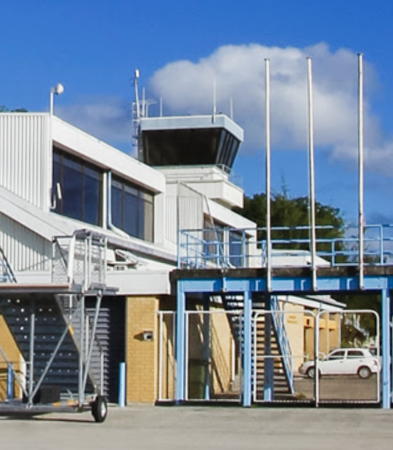
- Date unknown. Active; focal plane about 15 m (49 ft); flash every 5 s, alternately white and green. Mast atop the control tower of Nauru International Airport. Nick Hobgood has the street view also seen at right, Brandon Park has a distant view, and Google has a satellite view. This aviation beacon also serves as the landfall light for the island. Located at the south end of the island. Site open, tower closed. Admiralty K4771; NGA 11094.
Information available on lost lighthouses:
Notable faux lighthouses:

Nauru Light, Nauru, December 2013
ex-Google Maps street view by Nick Hobgood