Lighthouses of Oman

The Sultanate of Oman (ʿUmān in Arabic) occupies the southeastern corner of the Arabian Peninsula. The sultanate has been independent since the mid 18th century but for most of the 20th century it was under a British military protectorate. For many years the sultan barred most westerners and avoided modern developments, including lighthouses and port improvements. In 1970 the sultan was overthrown by one of his sons and since then the country has caught up rapidly with the rest of the Arab world. Tourism is encouraged and the country now attracts many visitors from the West and from Asia.

In addition to its lengthy coastline facing the Gulf of Oman to the north and the Arabian Sea to the south the sultanate includes the Musandam peninsula, which is strategically located on the south side of the Strait of Hormuz, the entrance to the Arabian/Persian Gulf. Musandam is separated from the rest of Oman by the emirate of Fujairah, one of the seven member states of the United Arab Emirates.

The Arabic word for a lighthouse is mnarh or manara (منارة). Ra's is the word for a cape or headland, and jazīrat is an island.

Aids to navigation in Oman are maintained by the Arabian Maritime and Navigational Aids Service (AMNAS), a private company based in Muscat (Masqaṭ), under a contract from the Omani government. In recent years AMNAS has been carrying out a major program of refurbishing existing lighthouses and building new ones. In April 2011 AMNAS announced that it would build three new lighthouses by the end of 2012: "one on the southern tip of Masirah, one in Ra's al Madrakah, which is further south of Duqm, and the third at the eastern end of Qibliyah, also known as the Halaniyat Islands, off the Dhofar coast." These new lights were all listed by the Admiralty in May 2015.

Special thanks to Ian Atkinson for information on the history of Omani lights.

ARLHS numbers are from the ARLHS World List of Lights. Admiralty numbers are from volume D of the Admiralty List of Lights & Fog Signals. U.S. NGA List numbers are from Publication 112.

General Sources
AMNAS charts maritime safety in Omani waters
This article in the Oman Observer reviewed the history of Omani lighthouses. Unfortunately it is no longer available online.
Online List of Lights - Oman
Photos by Thomas Philipp, Rainer Arndt, and Douglas Cameron posted by Alex Trabas.
World of Lighthouses - Oman
Photos by various photographers available from Lightphotos.net.
Lighthouses in Oman
Photos by various photographers available from Wikimedia.
GPSNauticalCharts
Navigational chart information for Oman.
Navionics Charts
Navigation chart for Oman.
Muscat Light
Muscat Light
AMNAS photo
Musandam (Strait of Hormuz) Lighthouses
[Ra's ash Shaykh Mas'ud (Ra's Shiekh Mas'ud)]
1982. Active; focal plane 19 m (62 ft); white flash every 5 s. Approx. 5 m (17 ft) post. Trabas has Arndt's photo and Gustavo Junqueira has a very distant view, but Google has only a fuzzy satellite view of the station. This light guides vessels toward the port of Khasab, the capital of the Musandam Governorate. Located on a promontory on the northwestern shoulder of the Musandam Peninsula. Site status unknown. Admiralty D7336; NGA 30160.
Dīdāmar (Jazīrat Quwayn as Saghir, Jazīrat Tadmur, Quoin Island)
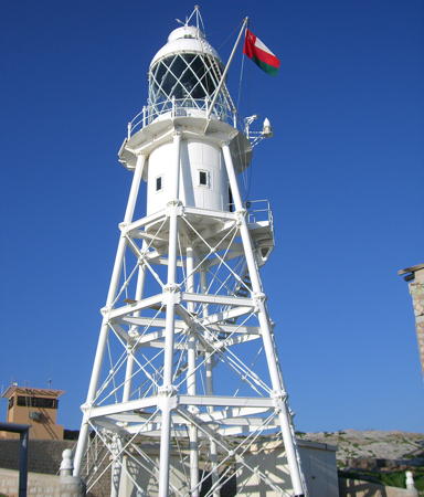
1914 (British). Active; focal plane 60 m (197 ft); two white flashes every 10 s. 24 m (79 ft) hexagonal pyramidal skeletal tower with lantern, gallery, and enclosed watch room. Entire lighthouse painted white. There are several keeper's houses, probably staffed by Omani forces keeping watch over this very strategic location (25% of the world's oil passes within sight of the lighthouse). A photo is at right and Bing has a satellite view. Built by the British, the lighthouse was maintained by the Indian Marine Service until 1951. The tower has a powerful light to guide ships through the Strait of Hormuz, the entrance to the Persian Gulf. NGA lists its range as 23 nautical miles (42.5 km or 26.5 mi). This historic lighthouse was restored in 2006. Located on a small rocky islet in the Strait about 25 km (15 mi) north of the northern tip of the Musandam Peninsula. Accessible only by boat. Site and tower closed. ARLHS OMA-001; Admiralty D7335; NGA 28552.

Gulf of Oman Lighthouses
Şohār
2002(?). Active; focal plane 15 m (49 ft); white, red or green light depending on direction, 2.5 s on, 2.5 s off. 14 m (46 ft) rectangular cylindrical steel skeletal tower. No photo available but Google has an indistinct satellite view. This leading light guides vessels through the entrance to the modern industrial harbor of Şohār, established in 2002. About 240 km (150 mi) northwest of Masqaṭ, the historic port of Şohār is the traditional home of the mythical Sindbad the Sailor. Today it is the capital of the Al Batinah North region. Located near the base of the east breakwater of Şohār. Site status unknown. Admiralty D7326.25; NGA 28588.1.
Wudam Approach
Date unknown. Active; focal plane 13 m (43 ft); white, red or green light depending on direction, 1 s on, 1 s off. Approx. 12 m (39 ft) post supporting a large lantern structure. No photo available but Google has a satellite view. The light guides vessels approaching the Said bin Sultan Naval Base. Located just east of the naval base at Wudam. Site status unknown. Admiralty D7324.5; NGA 28590.2.

Dīdāmar Light, Musandam
AMNAS photo
Juzor Ad Daymānīyāt (Daymaniyat Islands) (2)
1988 (station established 1981). Active; focal plane 31 m (102 ft); white flash every 10 s. 9 m (30 ft) square cylindrical skeletal tower. No photo available but Google has a satellite view. The Daymaniyat Islands are a chain of barren islands stretching east and west, about 15 km (9 mi) offshore and 60 km (38 mi) west of Masqaṭ. The islands are a nature reserve popular with scuba divers. Located on one of the largest of the islands, near the west end of the chain. Accessible only by boat. Site status unknown. ARLHS OMA-002; Admiralty D7324; NGA 28592.
Jazīrat Al Fahl
Date unknown. Active; focal plane 95 m (312 ft); white flash every 15 s. 6.5 m (21 ft) pyramidal quadrupod tower, upper portion enclosed by white triangular daymarks. Trabas has Philipp's photo, Rahul Guhathakurta has a distant view from the sea, and Google has a satellite view. Located atop Fahl (Fahal) Island, an isolated high island about 8 km (5 mi) northwest of Masqaṭ. Accessible only by boat. Site open, tower closed. Admiralty D7322; NGA 28600.
Masqaṭ (Muscat) (2)
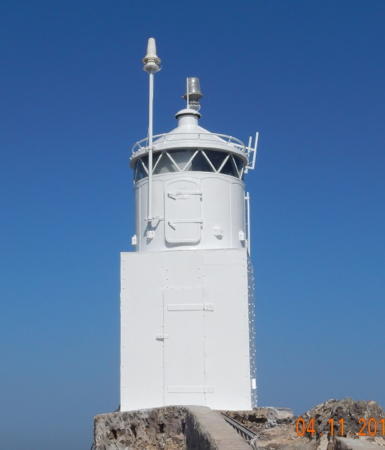
1963 (station established 1926). Active; focal plane 95 m (312 ft); white flash every 12 s. 5 m (17 ft) square pyramidal concrete tower with lantern. The entire lighthouse is white. There is a small equipment room adjoining the lighthouse. An AMNAS photo is at the top of this page, Trabas has Arndt's photo, Pete Goulding has photos, and Google has a satellite view. This historic light was upgraded and solarized in 2005, then refurbished and repainted in 2014. Located atop Jazirat Masqaṭ, the giant rock that shelters the harbor of Masqaṭ (Muscat), the capital of Oman. Site and tower closed. Admiralty D7320; NGA 28608.
Sidāb Main Breakwater
2020. Active; focal plane about 23 m (75 ft); red light, 2 s on, 2 s off. Approx. 20 m (66 ft) triangular concrete skeletal tower. Ahmed Al Rawahi has a distant view and a second distant view and Google has a satellite view. The Admiralty announced this light with a height of 4 m (13 ft); the photo reveals the much taller tower. The Sidāb harbor, on the south side of Masqaṭ, is the base for the Royal Oman Police Coast Guard. Located on the main breakwater of the harbor. Site and tower closed but there should be a view from shore. Admiralty D7318.7.
* Şūr (Ra's Ayqah, Ra's al 'Ayjah, Ra's Ayja)
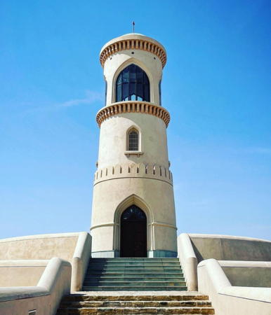
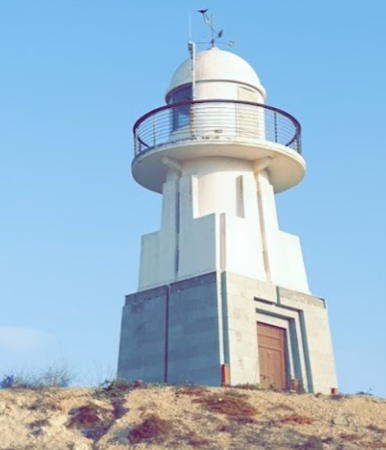
Date unknown (modern). Active; focal plane 20 m (66 ft); white flash every 5 s. 18 m (59 ft) 3-story tower with a domed roof. A 2022 photo is at right, Trabas has Philipp's view from the sea, a nice view is available, Mauro Gambini has a closeup street view, and Google has a good satellite view. Google also has a nighttime street view by Issa Rawahi showing how the tower is floodlit at night. Şūr, the capital of the Ash Sharqiyah South Governorate, is a historic port and trading center on the Gulf of Oman about 30 km (20 mi) west of Ra's al-Hadd, the easternmost tip of Arabia. Historically the town is known for the building of dhows, the traditional Arabian sailing ships. The lighthouse was probably built by local authorities as part of the development of the area as a resort. Located on Ras al 'Ayjah, the promontory on the east side of the harbor entrance. Site open, tower closed. . ARLHS OMA-003; Admiralty D7318.1; NGA 28618.

Sur Light, Sur, March 2022
Instagram photo by long.jerney

Arabian Sea Lighthouses
R'as al Hadd
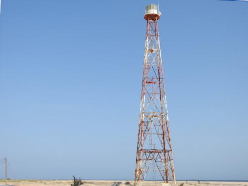
1969. Active; focal plane 42 m (138 ft); white flash every 10 s. 28 m (92 ft) square skeletal tower with lantern and gallery, painted with red and white horizontal bands. Lantern painted white. An AMNAS photo is at right, Ahmed Al Harthy has a 2021 photo, Zakarya Aljahwari has a 2023 photo, Lightphotos.net has a sunrise photo, and Google has a good satellite view. (Two other towers seen in the satellite view are presumably communications towers.) According to the AMNAS web site this lighthouse is scheduled for replacement "in due course." R'as al Hadd is a major cape at the southwestern tip of Arabia, marking the entrance to the Gulf of Oman from the Arabian Sea. Site status unknown. Admiralty D7318; NGA 30902.
Maşīrah Island (Ra's Abu Rasas)
2014 (?). Active; focal plane 89 m (292 ft); white flash every 10 s. 10 m (33 ft) round fiberglass tower colored with red and white horizontal bands. AMNAS has a photo, Benoît Almeras-Martino has a distant view of the light in action, and Google has a fuzzy satellite view. Maşīrah is a large but sparsely populated island off the northern Arabian Sea coast of Oman; it is 98 km (61 mi) long but only about 13 km (8 mi) wide for most of its length. The light is located on heights above the southern tip of the island. Site status unknown. Admiralty D7315.98.
Ra's al Madrakah
2014 (?). Active; focal plane 60 m (197 ft); white flash every 10 s. 10 m (33 ft) round fiberglass tower colored with red and white horizontal bands. AMNAS has a photo and Google has a satellite view. Ra's al Madrakah is a very prominent cape about 100 km (60 mi) south of Duqm on the central Arabian Sea coast of Oman. The light is located on heights above the cape. Site status unknown. Admiralty D7315.7.
Al Qiblīyah
2014 (?). Active; focal plane 95 m (312 ft); white flash every 10 s. 10 m (33 ft) round fiberglass tower colored with red and white horizontal bands. No photo available but Google has a satellite view. Al Qiblīyah is the easternmost of a string of five islands off the southern coast of Oman. The islands are known as Hallaniyat Islands in Oman, but they were known earlier to Westerners as the Khuriya Muria Islands. The Sultan of Muscat ceded the islands to Britain in 1854 and they were administered as part of the British colony of Aden, now part of Yemen. Britain retained control until 1967, when the islands were returned to Oman. Yemen claimed the islands until a boundary settlement in 1995 confirmed Omani ownership. Located on heights at the eastern end of Al Qiblīyah. Site status unknown. Admiralty D7315.38.
Ras al Hadd Light
R'as al Hadd Light, March 2016
AMNAS photo

Ṣalālah Lighthouses
Ṣalālah is the capital of the southern Omani governorate of Dhofar and the second largest city in the country, with a population of about 200,000. The city's port, developed and managed by a Danish company, is an important transshipment hub for container shipping.

Ṣalālah Main Channel
Date unknown. Active; focal plane 15 m (49 ft); continuous light, white, red or green depending on direction, visible only on or near the range line. 12 m (39 ft) skeletal tower. No photo available but Google has an indistinct satellite view. Located on the waterfront in the Raysūt Industrial area west of Ṣalālah. Site status unknown. Admiralty D7314.3; NGA 30913.6.
Ṣalālah Inner Channel
Date unknown. Active; focal plane 40 m (131 ft); continuous light, white, red or green depending on direction. 6 m (20 ft) rectangular cylindrical steel skeletal tower. No photo available and the small tower is not seen in Bing's satellite view. This is the leading light for entering the new harbor of Ṣalālah. Located atop a bluff overlooking the harbor. Site status unknown. Admiralty D7314.2; NGA 30911.
Ra's Raysūt (Ṣalālah)
2009. Active; focal plane 49 m (161 ft); white flash every 10 s. Approx. 12 m (39 ft) square masonry tower with lantern and gallery, painted white. An AMNAS photo is at right, Mina Zarif has a photo of the light in action, a 2021 closeup is available, Sayed Faisal has a distant street view, and Google has a satellite view. In October 2009 the Oman Times announced that the lighthouse had "just commenced operations." Located on the headland of Ra's Raysūt, which provides partial shelter for the harbor of Ṣalālah. Site status unknown. Admiralty D7314.55; NGA 30913.9.

Information available on lost lighthouses:

Notable faux lighthouses:


R'as Raysūt Light, Ṣalālah, March 2016
AMNAS photo

Adjoining pages: North: Southeastern Iran | Southwest: Yemen | West: United Arab Emirates

Return to the Lighthouse Directory index | Ratings key

Posted February 16, 2006. Checked and revised October 16, 2023. Lighthouses: 16. Site copyright 2023 Russ Rowlett and the University of North Carolina at Chapel Hill.