Lighthouses of the United Kingdom: Orkney, Scotland

The United Kingdom (officially the United Kingdom of Great Britain and Northern Ireland) includes England, Scotland, Wales, and Northern Ireland. Occupying the northern third of the island of Great Britain, the kingdom of Scotland has shared its monarch with England since 1603 and has been part of the United Kingdom since 1707. The coastline of the country is deeply cut by inlets, and there are more than 790 islands. The country has a long and distingushed maritime history; many of the most famous British captains and navigators have been Scots.

Orkney is a former county, now one of Scotland's 32 unitary council areas, including some 70 islands lying north of the mainland of Scotland. The islands are separated from the mainland by the narrow waters of Pentland Firth. Twenty of them are inhabited, the largest being Orkney Mainland. The town of Kirkwall is the administrative center. The population is about 22,500. The islands are accessible by air and by ferries from Aberdeen; they can also be reached by a shorter ferry ride from Scrabster on the mainland side of Pentland Firth.

Orkney was conquered by Vikings in the ninth century and remained at least nominally under Norse rule until it was annexed by Scotland in 1472. As a result there is a Norse influence on place names and geographical terms. A ness is a cape or headland, a flow (from the Norse floi) is a bay, and the ending -ay (from the Norse ey) means "island." A holm is a small rounded island and a skerry is a small, rocky island.

The Northern Lighthouse Board is responsible for building and maintaining the major lighthouses in these northern islands. Harbor lights are maintained by the Orkney Harbour Authority.

ARLHS numbers are from the ARLHS World List of Lights. Admiralty numbers are from Volume A of the Admiralty List of Lights & Fog Signals. U.S. NGA numbers are from Publication 114.

General Sources
Northern Lighthouse Board - Lighthouse Library
The Board's web site includes information and photos for many of the lighthouses.
Michael's Comprehensive List of Scottish Lights - Orkney Islands
Data and photos posted by Michael Spencer.
Lighthouse Archives
Lighthouse information from LighthouseAccommondations.uk.
Online List of Lights - Scotland
Photos by various photographers posted by Alexander Trabas. Many of the Orkney photos are by Ina Rendtel.
Lighthouses in the Orkney Islands
Photos available from Wikimedia; many of these photos were first posted on Geograph.org.uk.
World of Lighthouses - Scotland
Photos by various photographers available from Lightphotos.net.
United Kingdom Lighthouses
Aerial photos posted by Marinas.com.
The Stevensons
The history of Scotland's remarkable family of lighthouse engineers.
Britische Leuchttürme auf historischen Postkarten
Historic postcard images posted by Klaus Huelse.
GPSNavigationCharts
Navigation chart for Orkney.
Navionics Charts
Navigation chart for Orkney.

Noup Head Light
Noup Head Light, Westray, September 2008
Geograph Creative Commons photo by Nicholas Mutton

Southern Orkney Lighthouses

Pentland Firth and South Ronaldsay Lighthouses
Located in the southeastern quadrant of Orkney, South Ronaldsay is accessible from Orkney Mainland by a series of causeways built during World War II and known as the Churchill Barriers. The south end of the island faces Pentland Firth, the strait separating Orkney from the mainland of Scotland. The strait is dangerous to navigate because of very strong tidal currents.
Pentland Skerries Low
1794 (rebuilt 1825) (T. Smith and Robert Stevenson). Inactive since 1895. 18 m (60 ft) round stone tower with gallery; lantern removed. Tower painted white. Percy Quick's photo is at right. and Scottish Sea Kayaking has a 2021 photo. No longer used as a lighthouse, the tower now houses the station's fog horn (one 4.5 s blast every 45 s). ARLHS SCO-340.
Pentland Skerries High (Muckle Skerry)
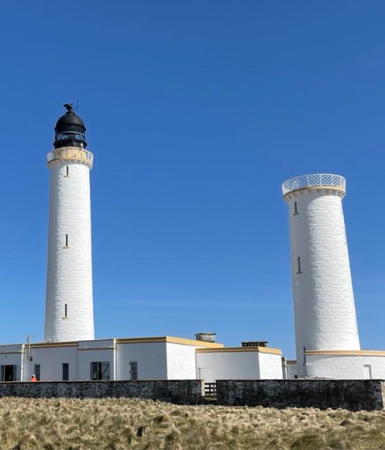
1794 (rebuilt 1825) (T. Smith and Robert Stevenson). Active; focal plane 52 m (171 ft); three white flashes, separated by 6 s, every 30 s. 36 m (118 ft) round stone tower with lantern and gallery. Tower painted white with buff trim; lantern painted black. 1-story keeper's houses and other light station buildings enclosed by a stone wall. Percy Quick's photo is at right, Sarah Takahashi has a 2022 photo, Lighthouse Accommodations has a page for the light station, George Brown has a photo, a good aerial photo is available, Trabas has a photo, Marinas.com also has aerial photos, Cailean Macleod has a distant view taken from Duncansby Head on the Scottish mainland, and Google has a satellite view. The Pentland Skerries are small rocky islands obstructing the eastern entrance to Pentland Firth. Located on Muckle Skerry, the largest of the group, about 8 km (5 mi) northeast of Duncansby Head on the mainland and 6 km (3.5 mi) south of Brough Ness, South Ronaldsay, in Orkney; the lighthouse is distantly visible from both locations. Accessible only by helicopter, as landing on the island is quite dangerous. Operator: Northern Lighthouse Board. . ARLHS SCO-169; Admiralty A3562; NGA 3020.
Lother Rock
1910. Active; focal plane 13 m (42 ft); quick-flashing white light. 12 m (39 ft) square skeletal tower with an open lantern structure. Trabas has Rendtel's closeup photo, Spencer has a photo, and Google has a distant street view, but the tower is hard to spot in Google's satellite view of the reef. Located on a rock south of Brough Ness, the southernmost point of South Ronaldsay; should be visible from that headland. Accessible only by boat. Site and tower closed. Operator: Northern Lighthouse Board. ARLHS SCO-131; Admiralty A3608; NGA 3024.
[Swona (2)]
Date unknown (station established 1906). Active; focal plane 17 m (56 ft); white flash every 8 s. Approx. 8 m (26 ft) concrete post light with a square gallery; the light is displayed from a short mast. Trabas has Rendtel's photo, Ian Balcombe has a very distant view, and Google has a satellite view. Swona is an uninhabited island in Pentland Firth about 6 km (3.5 mi) west of Brough Ness and a similar distance northeast of Stroma. Located at the southwestern tip of the island, known as the Tarf. Accessible only by boat. Site status unknown. Operator: Northern Lighthouse Board. ARLHS SCO-234; Admiralty A3607.5; NGA 3076.
Pentland Skerries Light
Pentland Skerries Low (left) and High Lights, November 2008
Flickr photo copyright Percy Quick; used by permission
* [Hoxa Head (2)]
1996 (station established 1901). Active; focal plane 15 m (49 ft); flash every 3 s, white or red depending on direction. 7 m (23 ft) square metal equipment shelter covered with white panels; the light is displayed from a short mast at the top. A concrete World War II lookout tower is near the lighthouse. Trabas has Rendtel's closeup photo, Spencer has photos, Jon Page has a view of the lookout tower and light, Marinas.com has aerial photos, and Bing has a satellite view. Huelse has a historic postcard view of the original lighthouse. Located on the northwestern point of South Ronaldsay, marking the east side of the Hoxa Sound entrance to Scapa Flow. Accessible by road about 7 km (4 mi) west of St. Margaret's Hope. Site open, tower closed. Operator: Northern Lighthouse Board. ARLHS SCO-103; Admiralty A3610; NGA 3100.
Nevi Skerry
Date unknown. Active; focal plane 7 m (23 ft); two white flashes every 6 s. 9 m (30 ft) round strongly conical solid concrete tower painted black with a red horizontal band. Trabas has Rendtel's photo, Spencer has foggy photos, and Bing has a satellite view. Located on a rocky ledge in the southern entrance to Scapa Flow, northwest of Hoxa Head and about 1 km (1.6 mi) off the northeastern point of Flotta. Accessible only by boat. Site status unknown. Operator: Northern Lighthouse Board. Admiralty A3610.6; NGA 3112.

Hoy Lighthouses
Hoy, located at the southwestern end of Orkney, is the second largest island of the group. It is accessible by ferries from Houton. Hoy Sound separates Hoy from Orkney Mainland and provides a northwestern entrance to the natural harbor of Scapa Flow between Hoy, Orkney Mainland, and South Ronaldsay. ("Flow" is derived from the Norse word flói meaning a bay or gulf.)

Ruff Reef
1881 (unlit until 1909). Active; focal plane 10 m (33 ft); two white flashes every 10 s. 10 m (33 ft) hexagonal skeletal tower with gallery. Spencer has a photo, Trabas has a photo by Tom Champagne, Google has a street view, and Bing has an indistinct satellite view. The tower was built in 1881 to warn mariners of the reef, and a light was added in 1909. Originally this light was maintained by the Cantick Head keepers. Located in Cantick Sound about 500 m (1/3 mi) north of Cantick Head Light. Accessible only by boat. Site and tower closed. Operator: Northern Lighthouse Board. ARLHS SCO-197; Admiralty A3604; NGA 3092.
* Cantick Head
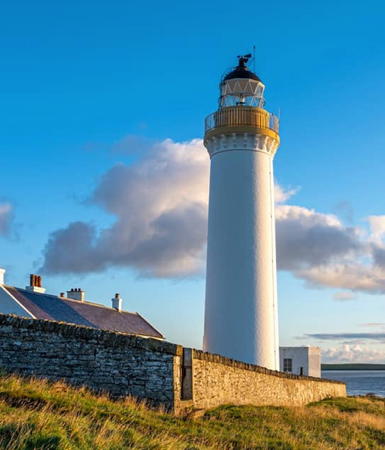
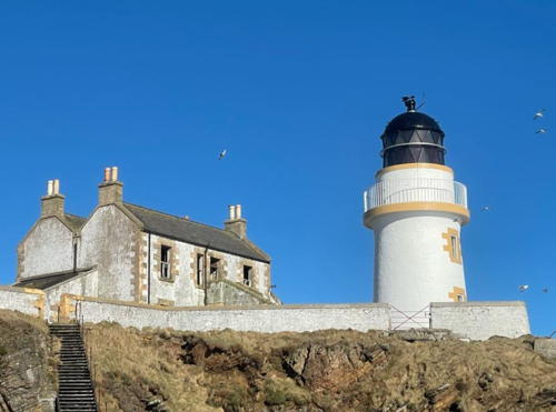
1858 (David and Thomas Stevenson). Active; focal plane 35 m (115 ft); white flash every 20 s. 22 m (72 ft) stone tower with lantern and gallery. Tower painted white with buff trim; lantern painted black. Two 2-story keeper's houses and other light station buildings, enclosed by a stone wall, available in recent years for overnight accommodations. John W. Schulze's photo is at right, David Barlow has a good photo, Trabas has a view from the sea by Tom Champagne, Lighthouse Accommodations has a page for the light station, Marinas.com has aerial photos, Huelse has a historic postcard view, and Google has a street view and a satellite view of the station. The lighthouse marks the southern entrance to Scapa Flow. In February 2017 the light station was for sale for £300,000. Located at the eastern end of South Walls, an island connected to Hoy by a causeway. Accessible by road. Site open, tower closed. Operator: Northern Lighthouse Board. Site manager: Cantick Head Lighthouse Cottages . ARLHS SCO-038; Admiralty A3602; NGA 3088.
Tor Ness (2)
1937. Active; focal plane 21 m (69 ft); white flash every 3 s. 8 m (26 ft) round cylindrical cast iron tower with lantern and gallery, painted white. A 2008 closeup photo is available, Trabas has Tom Champagne's photo, Spencer has photos, Marinas.com has aerial photos, and Google has a satellite view. Located at the southwestern corner of Hoy marking the northwestern entrance to Pentland Firth, 13 km (8 mi) north of Dunnet Head Light on the mainland. The site does not appear to be accessible by road. Site open, tower closed. Operator: Northern Lighthouse Board. ARLHS SCO-244; Admiralty A3600; NGA 3084.

Cantick Head Light, Hoy, May 2014
Flickr Creative Commons photo by John W. Schulze

Graemsay (Hoy Sound) and Scapa Flow Lighthouses
Graemsay is a small but inhabited island north of Hoy and south of Stromness in Hoy Sound, about 8 km (5 mi) northwest of Scapa Flow. It is accessible by passenger ferry from Stromness and from Hoy.
Hoy Sound Low (Graemsay Island Range Front)
1851 (Alan Stevenson). Active; focal plane 17 m (56 ft); white light, 1.5 s on, 1.5 s off. 12 m (39 ft) round cylindrical stone tower with lantern and gallery, unpainted; lantern painted black. 1-story stone keeper's house enclosed by stone wall. World War II fortifications surround the site. The keeper's house is a private residence. Trabas has an excellent photo by Rendtel, a 2007 closeup is available, Orkney Heritage has a 2019 photo, Lighthouse Accommodations has a page for the two range lighthouses, Spencer has several photos, Marinas.com has aerial photos, and Google has a satellite view and a very distant street view across the sound. The range guides ships eastbound, entering Hoy Sound and Scapa Flow from the Atlantic. Located on the north point of Graemsay Island, about 2.2 km (1.4 mi) west of the high lighthouse. Site and tower closed; the lighthouse can be viewed from nearby, but it's a fairly long walk from the ferry terminal. Operator: Northern Lighthouse Board. ARLHS SCO-174; Admiralty A3644; NGA 3196.
* Hoy Sound High (Graemsay Island Range Rear)
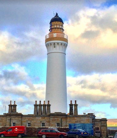
1851 (Alan Stevenson). Active; focal plane 35 m (115 ft); white or red light, depending on direction, 6 s on, 2 s off. 33 m (108 ft) round stone tower with lantern and gallery, painted white; lantern painted black. 1-story keeper's houses and other buildings enclosed by a stone wall. Orkney Heritage has the 2019 photo seen at right, Trabas has a photo by Rendtel, Ian Horne has a good photo, Spencer has several photos, Marinas.com has aerial photos, Huelse has a historic postcard view, and Google has a satellite view. Located on the northeast point of the island. The island is accessible by passenger ferry from Stromness; there is a walk of about 1.5 km (1 mi) roundtrip to visit the lighthouse. Site open, tower closed. Operator: Northern Lighthouse Board. . ARLHS SCO-104; Admiralty A3644.1; NGA 3200.
Cava
1898. Active; focal plane 11 m (36 ft); flash every 3 s, white or red depending on direction. 9.5 m (29 ft) round cylindrical cast iron tower with lantern and gallery, painted white. A nice closeup photo is available, Trabas has Rendtel's photo, Lightphotos.net has a photo, Spencer has foggy photos, Marinas.com has aerial photos, and Bing has a satellite view. Located at the northern tip of Cava, an island in the northwestern corner of Scapa Flow and the eastern entrance to Hoy Sound. Accessible only by boat; visible from ferries between Houton and Flotta. Accessible only by boat. Site open, tower closed. Operator: Northern Lighthouse Board. ARLHS SCO-044; Admiralty A3636; NGA 3176.

Hoy Sound High Light, Graemsay, October 2019
Google Maps photo by Orkney Heritage
Barrel of Butter
1980. Active; focal plane 6 m (19 ft); two white flashes every 10 s. 6 m (19 ft) conical masonry tower, topped by a small platform. No lantern; the light is displayed from a short mast at the top. George Brown has a closeup photo, Trabas has Rendtel's photo, Marinas.com has good aerial photos, and the reef and light are visible in Bing's satellite view. Located on a rock in the northwestern corner of Scapa Flow about 5 km (3 mi) southeast of Houton. Accessible only by boat, but this and all the Scapa Flow lights are visible from numerous interisland ferries. Site and tower closed. Operator: Northern Lighthouse Board. ARLHS SCO-017; Admiralty A3635; NGA 3172.

Central Orkney Lighthouses


Eastern Orkney Mainland Lighthouses
Copinsay
1915 (David A. Stevenson). Active; focal plane 79 m (259 ft); five white flashes, separated by 2.5 s, every 30 s. 16 m (52 ft) round stone tower with lantern and gallery, painted white with buff trim; lantern painted black. 1-story keeper's house and other buildings. Peter Gordon has a closeup, another photo is available, Trabas has Rendtel's photo, Lighthouse Accommodations has a page for the lighthouse, Marinas.com has aerial photos, and Google has a satellite view. Copinsay is a small island about 5 km (3 mi) southeast of Point of Ayre on the east side of Orkney Mainland. Formerly inhabited, the island is now a sanctuary owned by the Royal Society for the Protection of Birds. Located on the highest point of the island. Accessible only by boat; should be visible from Point of Ayre. Site and tower closed (sensitive ecological preserve). Operator: Northern Lighthouse Board. Site manager: Royal Society for the Protection of Birds (Copinsay Nature Reserve). . ARLHS SCO-049; Admiralty A3676; NGA 3228.
Rose Ness (2)
1983 (station established 1905). Active; focal plane 24 m (79 ft); white flash every 6 s. 8 m (26 ft) round cylindrical cast iron tower with lantern and gallery, painted white. A photo by Karin Baruschke is at right, Trabas has Rendtel's closeup photo, Marinas.com has aerial photos, and Google has a satellite view. This is a sibling of the Cava lighthouse (above). The light supplements a historic daybeacon, a square rubblestone pyramid topped by a wood cross, built in 1867. Doug Lee has a closeup photo of the beacon. Located at the southeastern corner of Orkney Mainland, about 5 km (3 mi) southeast of St. Mary's. The site appears to be accessible by a hike of about 1.2 km (3/4 mi) from the end of the road at Cornquoy. Site status unknown. Operator: Northern Lighthouse Board. ARLHS SCO-186; Admiralty A3626; NGA 3164.

Rose Ness Light, St. Mary's, June 2023
Google Maps photo by Karin Baruschke

Western Orkney Mainland Lighthouses

*
[Sule Skerry Shore Station]
Date unknown. 2-story stone house. Google has a street view and a satellite view. Off-duty keepers and families of keepers of the Sule Skerry lighthouse, located 65 km (40 mi) west of Orkney, stayed in this house in Stromness. Michael Ellison reports that the house is now converted into four flats and that there is a lighthouse carved in the stonework above the front door. Located at 4b Ness Road in Stromness. Site open, building closed.
* [Stromness Range Front]
Date unknown. Active; focal plane 39 m (128 ft); continuous red light. 4 m (13 ft) mast mounted on an octagonal concrete pillar. Pillar painted white. Trabas has Kees Aalbersberg's photo, Spencer has a photo, Google has a street view, and Bing has a satellite view. Located on Hellihole Road on the hillside above Stromness. Site open, tower closed. Admiralty A3656; NGA 3212.
* [Stromness Range Rear]
Date unknown. Active; focal plane 29 m (95 ft); continuous red light. 6 m (20 ft) mast mounted on an octagonal concrete pillar. Pillar painted white. Trabas has Kees Aalbersberg's photo, Spencer has a photo, Google has a street view, and Bing has a satellite view. Located on Hellihole Road 55 m (180 ft) above the front light. Site open, tower closed. Admiralty A3656.1; NGA 3216.
[Skerry of Ness (2)]
1981 (station established 1895). Active; focal plane 10 m (33 ft); white or green flash every 4 s, depending on direction. 10 m (33 ft) concrete post, the light displayed from a small platform at the top. Trabas has a photo by Capt. Peter Mosselberger, a 2007 closeup is available, Spencer has a photo, Marinas.com has aerial photos, and Bing has a distant satellite view. The original lighthouse was a stone tower built by David A. Stevenson. Located just off the southwestern point of Orkney Mainland, across from the Hoy Sound lighthouses on Graemsay. Visible from the end of the A965 highway about 2 km (1.2 mi) south of Stromness. Site and tower closed. Operator: Northern Lighthouse Board. ARLHS SCO-214; Admiralty A3650; NGA 3204.
* Brough of Birsay
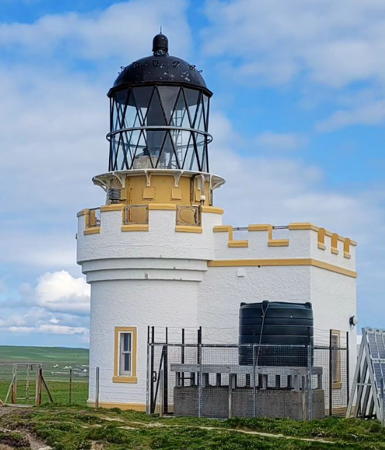
1925 (David A. Stevenson). Active; focal plane 52 m (171 ft); three white flashes, separated by 4 s, every 25 s. 11 m (36 ft) round cylindrical castellated tower with lantern and gallery, attached to a 1-story equipment room. Lighthouse painted white with buff trim; lantern painted black. A photo is at right, Alan Jamieson has a similar 2018 photo, Nicholas Mutton has a 2008 photo, Martin Brewster has a good closeup photo, Trabas has Rendtel's photo, Spencer has three photos, Lighthouse Accommodations has a page for the lighthouse, Marinas.com has aerial photos, Richard Harris has a street view, and Google has a satellite view. Brough of Birsay is a small island just off Brough Head, about 1 km (1/2 mi) west of Birsay on the northwestern corner of Orkney Mainland. (The unusual name of the island is somewhat redundant: a brough is a fort, and Birsey is from the Norse byrgisey, meaning fort island.) The island is accessible at low tide by a concrete walkway; parking is provided on the Mainland side, but check the tide schedules to avoid being strabded on the island. Located atop a bluff on the northwest side of the island. Site open, tower closed. Operator: Northern Lighthouse Board. . ARLHS SCO-023; Admiralty A3700; NGA 3224.
Brough of Birsay Light
Brough of Birsay Light, Orkney Mainland, August 2012
Wikimedia Creative Commons photo by Chmee2

Kirkwall Lighthouses
Kirkwall, a town of about 10,000 residents, is the administrative center of Orkney. The town was founded by Norse settlers at least by the eleventh century and its name comes from the Norse Kirkjuvágr (Church Bay). Today the town is a popular stop for cruise ships and a transport hub with ferry departures to many of the other islands.

* Kirkwall West Pier (2?)
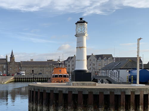
Late 1870s (station established 1854). Inactive since 1994. Approx. 6 m (20 ft) round cast iron tower with an ornate lantern. Tower painted white, base and lantern roof black. Michael Ellison's photo is at right, a 2007 photo is available, Calum McRoberts has a closeup, Bob Jones has a nice view, Google has a street view, and Bing has a distant satellite view. We need better information on the history of this light. The 1854 date is from Findlay's 1879 list, which does not describe the tower. The West Pier was built in the 1860s and extended in 1875 to its present length. Spencer says the lighthouse was built "about 1880." When the harbor was expanded in 1994, this historic light was deactivated and relocated to the west pier of the old inner harbor. The rusting tower was long in need of restoration but visitors in 2018 found it repainted and in better condition. Located on the waterfront of Kirkwall. Site open, tower closed. Owner/site manager: unknown. ARLHS SCO-321.
* Kirkwall West Pier (3?)
1994. Active; focal plane 13 m (43 ft); white, red or green light, depending on direction, 2.5 s on, 2.5 s off. 11 m (36 ft) robust concrete post painted white with a red horizontal band. Trabas has Hartmut Knape's photo, Spencer has a photo taken before the red band was added, and Bing has a satellite view. Located on the main pier at Kirkwall. Site open, tower closed. Owner/operator: Orkney Harbour Authority. Admiralty A3688; NGA 3244.

Older West Pier Light, Kirkwall, August 2021
photo copyright Michael Ellison; used by permission

Shapinsay Lighthouses
Shapinsay is an island separated from the northeast coast of Orkney Mainland by the narrow Shapinsay Sound. The island has a population of about 300 and is accessible by ferry from Kirkwall.

* Balfour
Date unknown. Active; focal plane 7 m (23 ft); two flashes every 5 s, white, red, or green depending on direction. 5 m (17 ft) post mounted on the side of a gray pierhead building. Trabas has Rendtel's closeup photo, Stephen McKay has a photo, Spencer has a photo, Google has a street view, and Bing has a satellite view. Located on the south pier at Balfour, the ferry terminal on the southwest side of Shapinsay opposite Kirkwall. Site open, tower closed. Owner/operator: Orkney Harbour Authority. Admiralty A3685; NGA 3240.
Helliar Holm (Saeva Ness)
1893 (David A. Stevenson). Active; focal plane 18 m (59 ft); flash every 10 s, white, red, or green depending on direction. 13 m (42 ft) round stone tower with lantern and gallery, painted white with buff trim; lantern painted black. The abandoned 2-story keeper's house and other buildings are in very poor condition. A 2022 photo is at right, Trabas has an excellent photo by Helmut Seger, a fine 2007 photo is available, Derek Mayes has a 2011 closeup, Mike Pennington has a photo of the light in action, Marinas.com has aerial photos, Huelse has a historic postcard view, and Bing has a satellite view. Ownership of the light station was transferred to the Orkney Islands Council in October 2014. Helliar Holm is an island in Shapinsay Sound between Shapinsay and Orkney Mainland, on the north side of the Mainland. Located on Saeva Ness on the south side of the island. Accessible only by boat, but there are good views from the ferry between Kirkwall on Orkney Mainland and Balfour on Shapinsay. Site open, tower closed. Owner: Orkney Islands Council. Operator: Orkney Harbour Authority. . ARLHS SCO-094; Admiralty 3684; NGA 3236.

Helliar Holm (Saeva Ness) Light, Shapinsay, Aupril 2022
Instagram photo by thesmiddykirkwall

Northern Orkney Lighthouses

Westray Lighthouse
* Noup Head
1898 (David A. and Charles Stevenson). Active; focal plane 70 m (259 ft); white flash every 30 s. 24 m (79 ft) round masonry tower with lantern and gallery, attached to 1-story service building. Tower painted white, lantern black. Keeper's houses demolished. Nicholas Mutton's 2008 photo is at the top of this page, Kevin Law has a 2022 photo, Craig Taylor has a photo, John Tustin also has a photo, Trabas has Rendtel's photo, Lighthouse Accommodations has a page for the lighthouse, Marinas.com has aerial photos, and Google has a good satellite view. The lighthouse marks the northwestern corner of Orkney on the island of Westray. Located atop a spectacular vertical cliff at the western tip of the island about 7 k (4 mi) northwest of Pierowall. The island is accessible by ferries from Kirkwall; the lighthouse is accessible by road, but 4WD is recommended. Site open, tower closed. Operator: Northern Lighthouse Board. . ARLHS SCO-158; Admiralty A3736; NGA 3292.

North Ronaldsay Lighthouses
North Ronaldsay is the northernmost island of Orkney and marks the northeastern extremity of the islands. The island has a small permanent population and is accessible by ferries on Tuesdays and Fridays during the summer and weekly as weather permits during the rest of the year.

**
North Ronaldsay (2)
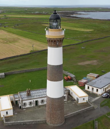
1854 (Alan Stevenson). Active; focal plane 43 m (141 ft); white flash every 10 s. 42 m (138 ft) round brick tower with lantern and gallery. The lighthouse is painted with two white horizontal bands that contrast with the dark red color of the bricks. The keeper's houses and other light station buildings were purchased from the lighthouse board by the North Ronaldsay Trust in 2003; they have been renovated and are available for overnight accommodation. A keeper hired by the Trust lives in one of the houses. John Tustin's photo is at right, Rob Burke has a photo, Lis Burke has a wider view, Trabas has Rendtel's photo, Lighthouse Accommodations has a page for the lighthouse, Marinas.com has aerial photos, Google has a closeup street view, and Bing has a satellite view. Located on the Point of Sinsoss near the northeastern tip of North Ronaldsay, about 1 km (0.6 mi) northwest of the 1789 lighthouse. The island is accessible by air; ferries from Kirkwall operate only once a week on Fridays, May through September. Site open; tower open to guided tours by arrangement with the keeper and on Sunday afternoons during the summer. Operator: Northern Lighthouse Board. Site owner/manager: North Ronaldsay Trust. . ARLHS SCO-155; Admiralty A3722; NGA 3280.
* North Ronaldsay (1) (Dennis Head Old Beacon)
1789 (Thomas Smith). Inactive since 1809. 21 m (70 ft) round stone tower, unpainted. No lantern. Foundations of the original keeper's house are located next to the tower. The third lighthouse built by the Northern Lighthouse Board, this tower was deactivated after the first Start Point Light was completed. The lantern was replaced by a masonry cap, and the tower was retained as a daybeacon. Jennifer Batten has a good photo, Mimi Chan has a 2021 photo, Alex Cameron has another photo, and Bing has a satellite view. In 2008 the North Ronaldsay Trust received £50,000 from the Heritage Lottery Fund and £45,000 from the Orkney Islands Council; these funds were used for an engineering study and emergency work to stabilize the building and remove two centuries' worth of bird droppings from the interior. Further restoration is planned. Chris Downer's 2015 photo shows the tower surrounded by scaffolding. Located at the most easterly point of Dennis Head about 1 km (0.6 mi) southeast of the 1854 lighthouse at the northeastern tip of North Ronaldsay. The island is accessible by air; ferries from Kirkwall operate only once a week on Fridays, May through September. Site open, tower closed. Owner/site manager: North Ronaldsay Trust. ARLHS SCO-154.
North Ronaldsay Light
1854 North Ronaldsay Light, April 2004
Geograph Creative Commons photo by John Tustin

Sanday and Eday Lighthouses
** Start Point (2)
1870 (Thomas Smith and Robert Stevenson). Station established 1806. Active; focal plane 24 m (79 ft); two white flashes, separated by 2.5 s, every 20 s. 23 m (75 ft) round stone tower with lantern and gallery, painted with black and white vertical stripes; lantern painted black. The 2-story keeper's house is occupied as a private residence, but the owner also looks after the lighthouse informally. A photo by Dimitris Kafantaris is at right was taken on the 200th anniversary of the light station, 2 October 2006. Trabas has Rendtel's closeup photo, Darran Brook has a 2022 closeup, a 2007 view is available, Marinas.com has aerial photos, and Bing has a satellite view. Huelse has a historic postcard view and a second postcard view that shows the lighthouse painted with the present vertical stripes. This is the easternmost lighthouse of Orkney, located on a small island off the northeastern tip of Sanday Island. Sanday is accessible by ferry, and the lighthouse can be reached on foot at low tide. Tours guided by the owner of the island are available. Site and tower open by appointment. Operator: Northern Lighthouse Board. ARLHS SCO-225; Admiralty A3718; NGA 3276.
* Kettletoft Pier
Date unknown. Active; focal plane 7 m (23 ft); flash every 3 s, white, red or green depending on direction. 6 m (20 ft) rectangular white concrete tower attached to a 1-story pier building. Trabas has Rendtel's closeup photo, Google has a street view, and Bing has a satellite view. Located at the end of the pier at Kettletoft, a small port on the south side of Sanday. Accessible by walking the pier. Site open, tower closed. Admiralty A3716; NGA 3272.
Calf of Eday (Calf Sound) (2)
2002 (station established 1909). Active; focal plane 9 m (30 ft); three flashes every 10 s, white, red, or green depending on direction. 9 m (30 ft) octagonal cylindrical aluminum tower with lantern and gallery. Entire lighthouse painted white. Eday is an island southwest of Sanday, and Calf of Eday is a smaller island to the northeast, separated from Eday by Calf Sound. This directional light has white sectors defining the proper entry to Calf Sound from both north and south. There were protests when the Lighthouse Board announced plans for the replacement of the original lighthouse in 2000; as a result, the Board replaced the light with an aluminum replica of the original. Rob Burke has a 2003 photo, a 2007 photo is available, Trabas has Rendtel's closeup photo, Marinas.com has aerial photos, and Bing has an indistinct satellite view. Located on Eday (not on Calf of Eday) about 800 m (1/2 mi) north of Blett. There should be good view from a walking trail northward from Blett. Island accessible by ferries from Kirkwall. Site status unknown. Operator: Northern Lighthouse Board. ARLHS SCO-034; Admiralty A3728; NGA 3288.

Start Point Light, Sanday, March 2021
Google Maps photo by Dimitris Kafantaris

Stronsay Lighthouses
[Papa Stronsay (2)]
2002 (?) (station established 1907). Active; focal plane 8 m (27 ft); white light, 2 s on, 2 s off. 5 m (17 ft) square skeletal tower covered with white aluminum panels, A blogger reports on a June 2007 NLB maintenance visit to the light and Google has a satellite view. Trabas has Kees Aalbersberg's view of the original lighthouse. Papa Stronsay is an island just off Whitehall at the northern tip of Stronsay. The island is privately owned as a cattle farm. Accessible only by boat. Site and tower closed. Operator: Northern Lighthouse Board. ARLHS SCO-167; Admiralty A3706; NGA 3268.
Auskerry
1867 (David and Thomas Stevenson). Active; focal plane 34 m (112 ft); white flash every 20 s. 34 m (112 ft) round stone tower with lantern and gallery, attached to a 2-story stone keeper's house. Ian Balcombe's photo is at right, a 2008 closeup photo is available. David Lewis has a distant view, Trabas has Helmut Seger's view from the sea, Lighthouse Accommodations has a page for the lighthouse, Marinas.com has aerial photos, Huelse has a historic postcard view, and Google has a satellite view. Located at the south end of Auskerry, a small, flat island about 5 km (3 mi) south of Stronsay on the east side of Orkney. Accessible only by boat. The lighthouse is distantly visible from Stronsay. Site and tower closed (the island is a privately owned sheep farm). Operator: Northern Lighthouse Board. ARLHS SCO-011; Admiralty A3680; NGA 3232.

Sule Skerry Lighthouse

Sule Skerry
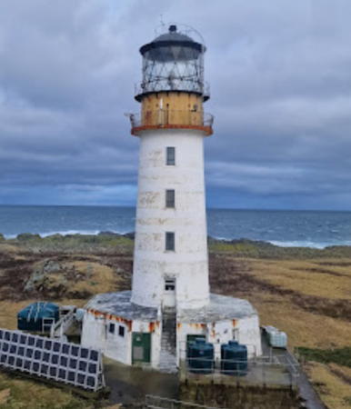
1895 (David A. and Charles Stevenson). Active; focal plane 34 m (113 ft); two white flashes, separated by 3.6 s, every 15 s. 27 m (88 ft) round masonry tower with lantern and gallery, painted white; lantern painted black. An automated weather station stands near the lighthouse. Trabas has Kees Aalbersberg's view from the sea, another photo is available, Lighthouse Accommodations has a page for the lighthouse, and Google has a satellite view. The lighthouse, considered the most isolated British light station, was originally equipped with a giant "hyperradiant" Fresnel lens almost 5 m (16 ft) in diameter. Sule Skerry is a rocky islet with an area of 15 ha (35 acres) about 65 km (40 mi) west of Orkney. The island is a critically important nesting site for birds. (In Scottish folklore it was also the home of the Great Silkie, a legendary creature featured in a folk song popularized for Americans by the singer Joan Baez.) Accessible only by boat or helicopter. Site and tower closed. Operator: Northern Lighthouse Board. ARLHS SCO-231; Admiralty A3868; NGA 3568.
Auskerry Light
Sunrise at Auskerry Light, Stronsay, March 2012
Geograph Creative Commons photo by Ian Balcombe

Information available on lost lighthouses:

Notable faux lighthouses:

Adjoining pages: North: Shetland | South: Highland Council Area

Return to the Lighthouse Directory index | Ratings key

Posted September 17, 2004. Checked and revised July 28, 2023. Lighthouses: 26. Site copyright 2023 Russ Rowlett and the University of North Carolina at Chapel Hill.