Lighthouses of the United Kingdom: Shetland, Scotland

The United Kingdom (officially the United Kingdom of Great Britain and Northern Ireland) includes England, Scotland, Wales, and Northern Ireland. Occupying the northern third of the island of Great Britain, the kingdom of Scotland has shared its monarch with England since 1603 and has been part of the United Kingdom since 1707. The coastline of the country is deeply cut by inlets, and there are more than 790 islands. The country has a long and distingushed maritime history; many of the most famous British captains and navigators have been Scots.

Shetland is a former county, now one of Scotland's 32 unitary council areas, occupying an archipelago lying about 160 km (100 mi) northeast of the Scottish mainland. There are at least 100 islands, of which 16 are inhabited. Shetland was the Norse colony of Hjaltland during medieval times, becoming part of Scotland in 1472. The islands are accessible by air and by NorthLink ferries from Aberdeen. The population is about 24,000.

The Northern Lighthouse Board is responsible for building and maintaining the lighthouses in these northern islands. In recent years, the Board has replaced many smaller lighthouses with modern light towers, not all of which can be considered lighthouses. On the other hand, increasing ship traffic in the area has caused the Board to construct a series of new towers in Yell Sound and along the western edge of the islands.

In Shetland place names, a ness is a cape or headland, a voe is a narrow bay, a holm is a small rounded island, and the ending -ay (from the Norse ey) means "island." Muckle is Scottish for "large."

ARLHS numbers are from the ARLHS World List of Lights. Admiralty numbers are from Volume A of the Admiralty List of Lights & Fog Signals. U.S. NGA numbers are from Publication 114.

General Sources
Northern Lighthouse Board - Lighthouse Library
The Board's web site includes information and photos for many of the lighthouses.
Michael's Comprehensive List of Scottish Lights
Data and photos posted by Michael Spencer.
Lighthouse Archives
Lighthouse information from LighthouseAccommondations.uk.
Lighthouses of the Shetland Islands
Photos and information for the major lighthouses, posted by Bob Schrage.
Online List of Lights - Scotland
Photos by various photographers posted by Alexander Trabas.
Lighthouses in the Shetland Islands
Photos by various photographers available from Wikimedia; many of these photos were first posted on Geograph.org.uk.
World of Lighthouses - Scotland
Photos by various photographers available from Lightphotos.net.
United Kingdom Lighthouses
Aerial photos posted by Marinas.com.
Britische Leuchttürme auf historischen Postkarten
Historic postcard images posted by Klaus Huelse.
The Stevensons
The history of Scotland's remarkable family of lighthouse engineers.
Famous Engineers of the Scottish Lighthouses
From Bob Schrage's website, a family tree and more information on the Stevensons.
GPSNavigationCharts
Navigational chart for Shetland.
Navionics Charts
Navigational chart for Shetland.


Ve Skerriies Light, Shetland, June 1999
unattributed photo posted by Bob Schrage

Lerwick Area Lighthouses
Lerwick is the principal town and administrative center for Shetland. The town has a population of about 6800.

Rova Head (2)
2002 (station established 1904). Active; focal plane 12 m (39 ft); two directional lights: both show three flashes every 18 s, white, red, or green depending on direction. 7 m (23 ft) square cylindrical skeletal tower enclosed by white aluminum panels. Spencer has a photo, Trabas has a closeup photo, and Google has a satellite view. There is a historic photo of the original lighthouse, a small cast iron tower. Located on an island on the west side of the northern entrance to Bressay Sound and Lerwick, off Blackhill Road about 5 km (3 mi) north of Lerwick. Accessible only by boat. Site open, tower closed. Operator: Northern Lighthouse Board. ARLHS SCO-187; Admiralty A3794; NGA 3404.
Loofa Baa
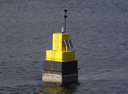
1913. Active; focal plane 4 m (13 ft); six quick white flashes followed by one long white flash every 15 s. 6 m (20 ft) 2-stage square solid concrete tower, upper half painted yellow and lower half black. Spencer has the photo seen at right, Trabas has Erich Hartmann's photo, and Google has a satellite view. Located on a reef in the center of Lerwick Harbour. Accessible only by boat. Site open, tower closed. Admiralty A3786; NGA 3376.
Lerwick Oil Jetty
Date unknown. Active; focal plane 5 m (17 ft); white flash every 3 s. 4 m (13 ft) post mounted on a small square 1-story pier office. Trabas has a photo by Nathalie Knopp, Spencer has a photo and Bing has a satellite view. Located on the jetty at the Lerwick oil terminal. Site and tower closed. Admiralty A3783.4; NGA 3368.
 

Looofa Baa Light, Lerwick
photo copyright Michael Spencer; used by permission
* [Lerwick Shore Station]
1950. 2-story dwelling; it served as the shore station for the Out Skerries Lighthouse until 1972 and then for several years as a secondary shore station for the Muckle Flugga Lighthouse. Google's 2015 street view shows the house under renovation. Google also has a satellite view. Located at 6 Breiwick Road in Lerwick. Site open, dwelling closed. Owner/site manager: private.
* Bressay (Kirkabister Ness) (1)
1858 (David and Thomas Stevenson). Inactive since 2012. 16 m (52 ft) round masonry tower with lantern and gallery, painted white; lantern painted black. A complete light station, including a principal keeper's house, two assistant keeper's houses, engine room, and other buildings enclosed by a stone wall. A photo appears at the top of this page, Trabas has Rainer Arndt's excellent photo, Rob Farrow has a 2011 photo, Paul Theakston has a 2022 photo, Wikimedia has distant views, Lighthouse Accommodations has a page for the lighthouse, Huelse has a historic postcard view, and Google has a street view and a satellite view. A complete light station, including a principal keeper's house, two assistant keeper's houses, engine room, and other buildings enclosed by a stone wall. In 1995 the buildings other than the light tower were sold to the Shetland Amenity Trust. The two assistant keeper's houses were renovated for overnight accomodations. In December 2012 the light was moved to an auxiliary building also carrying a radar antenna (next entry). In 2022 the Trust was seeking a new owner for the light station; the new owner would have to restore the water-damaged keeper's houses. Apparently none was found and now the keeper''s houses are described as "closed for maintennace." Located on Kirkabister Ness on the southwest side of the island of Bressay, marking the southern entrance to the harbor of Lerwick, the principal town of the Shetlands. The island is accessible by a short ferry ride from Lerwick, and the light station is accessible by road. Parking provided. Site open, tower closed. Owner/site manager: Shetland Amenity Trust. . ARLHS SCO-021.
Bressay (Kirkabister Ness) (2)
2012 (station established 1858). Active; focal plane 18 m (105 ft); two white flashes, separated by 2 s, every 20 s. 4 m (13 ft) round masonry tower topped by a radar antenna. Alan Niven has a 2019 photo. Located beside the historic lighthouse. Site open, tower closed. Operator: Northern Lighthouse Board. Site manager: Shetland Amenity Trust. Admiralty A3776; NGA 3340.
Bressay Light
Bressay Light, Lerwick, August 2009
Flickr Creative Commons photo by cowrin

Southern Shetland Mainland Lighthouses
Perie Bard (Mousa) (2)
Date unknown (recent) (station established 1951). Active; focal plane 20 m (66 ft); white flash every 3 s. 6 m (20 ft) square cylindrical skeletal tower enclosed by white aluminum panels. A 2008 view is available, Trabas has a photo by Darlene Chisholm, and Google has a fuzzy satellite view. The original lighthouse was relocated from No Ness on the mainland. Located on Perie Bard Islet at the east end of Mousa Island, off Sandwick on the southeast coast of Shetland Mainland, about halfway between the Sumbergh and Bressay lighthouses. Mousa, a Royal Society for the Protection of Birds sanctuary, is accessible in good weather by passenger ferry from Sandwick. Site status unknown. Operator: Northern Lighthouse Board. Site manager: Mousa Nature Reserve. ARLHS SCO-138; Admiralty A3772; NGA 3324.
**** Sumburgh Head
1821 (Robert Stevenson). Active; focal plane 91 m (300 ft); three white flashes, separated by 2.1 s, every 30 s. 17 m (56 ft) round masonry tower with lantern and gallery, painted white; lantern painted black. Rotating 1st order Fresnel lens (1914). 1-story keeper's houses and other buildings enclosed by a stone wall. This is the oldest Shetland lighthouse. The principal keeper's house is available for overnight accommodations. Ronnie Robertson's photo is at right, NLB has a page for the station, Markus Schroeder has a closeup photo, Richard Poppleton has a great closeup, Felix van de Gein's distant view reveals the spectacular setting of this lighthouse, Schrage has a page with good photos, Wikimedia has many photos of the station, Trabas has Erich Hartmann's photo, and Google has a 2015 street view and a satellite view. The area around the light station is a preserve managed by the Royal Society for the Protection of Birds; the preserve office is located in another of the keeper's houses. Located at the southern tip of Shetland Mainland about 2.5 km (1.5 mi) south of Sumburgh. In February 2008 the Shetland Amenity Trust announced that it would spend £1.5 million to restore the lighthouse and provide a visitor center, improved road access, and additional accommodations. These improvements were assisted by a grant of £683,000 from the Heritage Lottery Fund in October 2009. Additional funding was secured, and in May 2012 a £5.4 million contract was awarded to Corramore Construction Ltd. for a complete restoration and redevelopment of the light station. The original Muckle Roe lighthouse was relocated to serve as the entry kiosk for the station. Princess Anne opened the restored light station in ceremonies in June 2014. In February 2015 the restored foghorn was sounded for the first time since 1987. Accessible by road. Site and station buildings open daily April through September. Operator: Northern Lighthouse Board. Site manager: Sumburgh Head Lighthouse . ARLHS SCO-232; Admiralty A3766; NGA 3320.

Sumburgh Head Light, Virkie, December 2021
Flickr Creative Commons photo by Ronnie Robertson
* Muckle Roe (1) (relocated)
1897. Inactive since 2001. 8 m (26 ft) octagonal cast iron tower, painted white. A 3rd order Fresnel lens is mounted in the tower. Google has a street view and Bing has a satellite view. This historic lighthouse has been relocated to serve as the entry kiosk for the Sumburgh Head station. Trabas has a photo by Darlene Chisholm of the light at its original location. Site open, tower open during the summer opening hours for the station. ex-Admiralty A3844.

Western Shetland Lighthouses
* Fugla Ness (2)
1936 (station established 1893). Active; focal plane 20 m (66 ft); two flashes every 10 s, white, red, or green depending on direction. 8 m (26 ft) round cylindrical concrete tower with lantern and gallery, attached to a small equipment room. A closeup photo is at right, Colin Smith has a 2010 photo, Trabas has a photo by Darlene Chisholm, David Albutt has a 2022 photo, Bob Embleton has a sunset photo, Spencer has a photo, and Google has a distant satellite view and a distant street view from Hamnavoe. Located at the end of a rocky peninsula on the west side of the entrance to the harbor of Hamnavoe on West Burra, an island connected by bridge to Shetland Mainland. Accessible from town by a hike of about 1200 m (3/4 mi). Site open, tower closed. Operator: Northern Lighthouse Board. . ARLHS SCO-086; Admiralty A3858; NGA 3564.
* [White Ness (Ram's Head, Vaila Sound)] (2)
Date unknown (station established 1894). Active; focal plane 16 m (52 ft); flash every 8 s, white, red or green depending on direction. 5 m (17 ft) square cylindrical skeletal tower enclosed by white aluminum panels. A closeup photo is available and Google has a satellite view. Located on a promontory at the east side of the entrance to Vaila Sound and the west side of the entrance to Gruting Voe, about 1.5 km (1 mi) south of Whiteness. Site open, tower closed. Operator: Northern Lighthouse Board. ARLHS SCO-178; Admiralty A3850; NGA 3560.
Ve Skerries
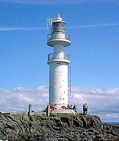
1979. Active; focal plane 17 m (56 ft); two white flashes, separated by 2 s, every 20 s. 16 m (52 ft) round cylindrical concrete tower with lantern and double gallery. An NLB photo is at the top of this page, Lighthouse Accommodations has a page for the lighthouse, Wikimapia has two photos, Trabas has a view from the sea by Kees Aalbersberg, and Google has a satellite view. The Ve Skerries are very dangerous rocks off Papa Stour island and the southwestern coast of Shetland Mainland. This modern lighthouse is anchored to one of the rocks by 18 steel bars. In 2020 the lighthouse was listed as a historic site by Historic Environment Scotland. Located about 10 km (6 mi) northwest of Melby. Accessible only by boat in tumultuous seas. Site and tower closed. Operator: Northern Lighthouse Board. ARLHS SCO-253; Admiralty A3847; NGA 3556.
Muckle Roe (Swarbacks Minn) (2)
2001 (station established 1897). Active; focal plane 30 m (98 ft); white flash every 3 s; red flashes are shown over rocks and shallow water near shore. 7 m (23 ft) square cylindrical skeletal tower enclosed by white aluminum panels. Steve Lucas has a good photo, Dean Parker has a 2022 photo, Trabas has a photo by Darlene Chisholm, and Google has an indistinct satellite view. The original lighthouse was stored with the intention of future display and in 2013 it was relocated to the Sumburgh Head lighthouse (see above). Muckle Roe is a circular island southwest of Brae on the western side of Shetland Mainland. The island has a population of about 130 and is accessible from Shetland Mainland by a bridge. Located on the southwestern side of the island marking the northern entrance to Swarbacks Minn, a broad sound leading to Brae, Voe, Aith, and other western Shetland ports. According to Lucas, hiking to the light is "quite a walk, but well worth it." Site open, tower closed. Operator: Northern Lighthouse Board. ARLHS SCO-141; Admiralty A3844; NGA 3552.
Fugla Ness Light
Fugla Ness Light, Hamnavoe, May 2004
Flickr Creative Commons photo by Iain R.

Northmavine Lighthouses
Northmavine is a wedge shaped peninsula at the northwestern corner of Shetland Mainland. The peninsula is connected to the rest of Shetland Mainland by an exceptionally narrow isthmus called Mavis Grind.
* [Hillswick (Ura Firth, Baa Taing)] (2)
Date unknown (station established 1895). Active; focal plane 34 m (112 ft); four flashes every 15 s, white or red depending on direction. 5 m (17 ft) square cylindrical skeletal tower enclosed by white aluminum panels. Trabas has Darlene Chisholm's closeup photo, Lis Burke has a photo, Wikimedia has distant views, and Google has a satellite view. Located on a promontory on the west side of the entrance to Ura Firth, about 1.6 km (1 mi) south of Hillswick. Site open, tower closed. Operator: Northern Lighthouse Board. ARLHS SCO-096; Admiralty A3840; NGA 3548.
* Esha Ness (Eshaness) (2)
1929 (David A. Stevenson). Station established 1915. Active; focal plane 61 m (199 ft); white flash every 12 s. 12 m (40 ft) square masonry tower with lantern and gallery, rising from 1-story keeper's house. Lighthouse painted white, lantern black. A photo is at right, Gavin Stone has a 2023 photo, Lighthouse Accommodations has a page for the lighthouse, Colin Smith has a 2010 photo, Schrage has a page for the lighthouse, Trabas has a photo by Tom Chisholm, Wikimedia has several photos, and Google has a street view and a satellite view. The keeper's house was sold as a private residence in 1974. In 1999 the house was purchased by Dean and Sharma Krauskopf and for several years Ms. Krauskopf contributed a monthly column to Lighthouse Digest on life at a lighthouse in the Shetlands. In early 2005 Sharma Krauskopf sold the house to the Shetland Amenity Trust, which has made it available for holiday accommodations. The lighthouse is the last in the long line of Stevenson-designed lighthouses in Scotland. The Northern Lighthouse Board considered deactivating the light in 2011 but dropped these plans in the face of strong public protests. Located on the Eshaness cliffs about 2 km (1.2 mi) north of Stenness. Accessible by road, and parking is available. Site and tower closed, but the lighthouse can viewed from outside the enclosure. Operator: Northern Lighthouse Board. . ARLHS SCO-075; Admiralty A3838; NGA 3544.
* Point of Fethaland
1977. Active; focal plane 65 m (213 ft); three flashes every 15 s, white or red depending on direction. 7 m (23 ft) round cylindrical tower with lantern, painted white. One of several modern lights built to guide tankers to the oil terminal at Sullom Voe near Firths Voe. Trabas has a photo by Kees Aalbersberg, Marion Müller has a distant view with Gruney Island (next entry) in the distance, Schrage has a page for the lighthouse, and Google has a satellite view. The Isle of Fethaland (actually a narrow-necked peninsula, not an island) is the picturesque northern tip of Shetland Mainland. Located near the extreme tip of the peninsula, accessible by a hiking trail. Site open, tower closed. Operator: Northern Lighthouse Board. ARLHS SCO-173; Admiralty A3817.5; NGA 3448.

Esha Ness Light, Stenness, October 2013
Wikimedia Creative Commons photo by Christiantomato
Gruney (2)
2004 (station established 1976). Active; focal plane 53 m (174 ft); white flash every 5 s; red flashes are shown to the west and southwest. 7 m (23 ft) square skeletal structure covered by white aluminum panels as a daymark. Trabas has a photo by Kees Aalbersberg and Google has a satellite view. Two keeper's houses survive from the original light station. In December 2003 the Navigation Committee of the Northern Lighthouse Board voted to replace the original light with the "standard aluminum lattice tower." The island is privately owned but managed by the Royal Society for the Protection of Birds. In 2015 the entire island, including the two keeper's houses, was for sale for £85,000. Located on a rocky island about 2.5 km (1.5 mi) north of the Point of Fethaland Light; Site and tower closed (bird sanctuary). Operator: Northern Lighthouse Board. Site manager: Royal Society for the Protection of Birds. ARLHS SCO-093; Admiralty A3817; NGA 3444.

Yell and Yell Sound Lighthouses
Located northeast of Shetland Mainland, Yell is the second largest of the Shetland Islands. The island has a population of a little less than 1000 and is readily accessible by auto ferries from Toft on Shetland Mainland. Yell Sound is a broad sound on the west side of Yell, separating Yell from Northmavine.

Lamba
Date unknown. Active; focal plane 30 m (98 ft); flash every 3 s, white, red or green depending on direction. 8 m (26 ft) white tower, form unknown. No photo available but Bing has an indistinct satellite view. Located at the southwest tip of Lamba, an island in southwestern Yell Sound. Accessible only by boat. Site status unknown. ARLHS SCO-119; Admiralty A3821; NGA 3468.
* Ness of Sound (2)
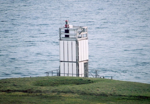
Date unknown (station established 1909). Active; focal plane 18 m (59 ft); three flashes every 12 s, white, red or green depending on direction. 8 m (26 ft) square cylindrical skeletal tower enclosed by white aluminum panels. Anna Jenšíková's photo is at right, Mike Pennington has a 2010 photo and a view from the sea, Spencer has a photo, Trabas has Darlene Chisholm's photo, and Google has a satellite view. Located on the west side of a blunt peninsula projecting into Yell Sound, about 4 km (2.5 mi) north of the ferry terminal at Ulsta on the south end of Yell. Accessible by a hiking trail off the A968 highway between Clothan and West Yell. Site open, tower closed. Operator: Northern Lighthouse Board. ARLHS SCO-148; Admiralty A3814; NGA 3432.
Little Holm
1976. Active; focal plane 12 m (39 ft); white light, 2 s on, 2 s off. 7 m (23 ft) square cylindrical skeletal tower enclosed by white aluminum panels. No closeup photo available; Trabas has a view by Kees Aalbersberg, Spencer has a photo and Google has an indistinct satellite view. Little Holm is an island in the middle of Yell Sound about 2.5 km (1.5 mi) south of Muckle Holm. Site and tower closed (bird sanctuary). Operator: Northern Lighthouse Board. Site manager: Royal Society for the Protection of Birds. ARLHS SCO-124; Admiralty A3819; NGA 3456.
Muckle Holm
1976. Active; focal plane 32 m (105 ft); four white flashes every 10 s. 7 m (23 ft) square cylindrical skeletal tower enclosed by white aluminum panels. Trabas has a photo by Kees Aalbersberg, Spencer has a photo and Google has a satellite view. Muckle Holm is an island in the middle of Yell Sound about 4 km (2.5 mi) east of North Roe on Shetland Mainland and a similar distance west of West Sandwick on Yell. Site and tower closed (bird sanctuary). Operator: Northern Lighthouse Board. Site manager: Royal Society for the Protection of Birds. ARLHS SCO-140; Admiralty A3818; NGA 3452.
Ness of Sound Light
Ness of Sound Light, Ulsta, June 2006
photo copyright Anna Jenšíková; used by permission
Bagi Stack
1976. Active; focal plane 45 m (148 ft); four white flashes every 20 s. 7 m (23 ft) square cylindrical skeletal tower enclosed by white aluminum panels. Mike Pennington has a distant view and Google has a satellite view. Located atop a cliff on the northwestern point of the island of Yell. This site does not appear to be accessible by road. Site and tower closed. Operator: Northern Lighthouse Board. ARLHS SCO-013; Admiralty A3816; NGA 3440.
* [Whitehill (Vatsetter) (2)]
2001 (station established 1904). Active; focal plane 24 m (79 ft); flash every 4 s, white or red depending on direction. 5 m (17 ft) square skeletal structure covered by white aluminum panels as a daymark. Spencer has a photo and Google has a satellite view. The original lighthouse was relocated to a traffic roundabout in Arbroath, Angus (see the Eastern Scotland page). Located on a promontory on the central east coast of Yell, about 6 km (4 mi) east of Mid Yell. Accessible by a hike of about 3 km (2 mi) from the end of the road at Vatsetter. Site open, tower closed. Admiralty A3824; NGA 3520.

Unst Lighthouses
The northernmost inhabited island of the British Isles, Unst lies northeast of Yell and has a population of about 700. The island is accessible by auto ferries across Bluemull Sound from Gutcher on Yell.
Muckle Flugga (North Unst)
1858 (David and Thomas Stevenson). Active; focal plane 66 m (215 ft); two white flashes, separated by 3.5 s, every 20 s. 20 m (66 ft) round masonry tower with lantern and gallery, rising from 1-story keeper's house. Lighthouse painted white; lantern painted black. Roine Johansson's photo is at right, Douglas Law's photo is at right, Wikipedia has a page with two photos, Mike Pennington has a closeup photo, Keane Beamish has a photo, Trabas has a photo, Schrage has a page for the lighthouse, uklighthousetour.com has closeup photos from a 2019 visit, Huelse has a historic postcard view, and Google has a satellite view. This lighthouse marks the northernmost point of the British Isles off the northwestern point of the island of Unst. The area is incorporated in the Hermaness National Nature Reserve and the reserve's visitor center at Haroldswick is housed in one of the buildings of the former shore station of the lighthouse (Google has a street view and a satellite view of the station). Pennington's 2005 photo illustrates the difficult access to the lighthouse. Muckle Flugga appears on many lists of odd place names but the name isn't so odd in Scottish. A flugga, from the Norse flugey, is a steep-sided island, and muckle means large. Located atop a steep-sided rocky islet; accessible only by helicopter (landing from boats is very dangerous). Site and tower closed. Operator: Northern Lighthouse Board. . ARLHS SCO-139; Admiralty A3832; NGA 3540.
* Holm of Skaw
Date unknown. Active; focal plane 8 m (26 ft); white flash every 5 s. 6 m (20 ft) square cylindrical skeletal tower enclosed by white aluminum panels. Trabas has a closeup photo by Kees Aalbersberg, Mike Pennington has a distant view, Spencer has a photo and Google has a satellite view. Located on a small island at the northeastern tip of Unst. Site open, tower closed. Operator: Northern Lighthouse Board. ARLHS SCO-098; Admiralty A3834; NGA 3542.
[Balta Sound (2)]
2004 (station established 1895). Active; focal plane 17 m (56 ft); flash every 10 s, white or red depending on direction. 5 m (17 ft) square cylindrical skeletal tower enclosed by white aluminum panels. Mike Pennington has a photo, Trabas has a closeup by Tom Chisholm, Spencer has a photo and Google has a satellite view. The original lighthouse, designed by David A. Stevenson, was one of the first concrete lighthouses in the U.K. Pennington has a 2003 photo of the old light. The lantern and lens of the old lighthouse have been donated to the Shetland Amenity Trust for display at a location which had not been determined. Located on the east side of Balta, an island off the entrance to Balta Sound and Unst. Accessible only by boat. Site open, tower closed. ARLHS SCO-014; Admiralty A3828; NGA 3524.

Muckle Flugga Light, Unst, June 2019
Instagram photo by Douglas Law
Uyea Sound
1946. Active; focal plane 7 m (23 ft); two white flashes every 8 s. 6 m (20 ft) mast atop a round white concrete tower. Spencer has photos, Trabas has Nathalia Knopp's distant view and Google has a distant satellite view. Uyea Sound is a strait separating the south coast of Unst from the uninhabited island of Uyea. Located on the beach at the west end of the sound. Site status unknown. ARLHS SCO-250; Admiralty A3830; NGA 3528.

Firth and Lunna Area Lighthouses
* Firths Voe
1909 (David A. and Charles Stevenson). Active; focal plane 9 m (29 ft); light 6 s on, 2 s off, white, red, or green depending on direction. 9 m (29 ft) round cylindrical cast iron (?) tower with lantern and gallery, painted white. 1-story stone keeper's cottage. Part of Danny Graham's street view is at right, Trabas has a photo by Darlene Chisholm, Mike Pennington has a photo, Spencer has a photo, and Google has a satellite view. A voe is an inlet or narrow bay. This is a leading light for vessels entering the voe from Yell Sound. Located in Firth, on the northern part of Shetland Mainland. Site open, tower closed. Operator: Northern Lighthouse Board. ARLHS SCO-082; Admiralty A3812; NGA 3428.
Lunna Holm
1985. Active; focal plane 19 m (62 ft); three white flashes every 15 s, white, red, or green depending on direction. 7 m (26 ft) round cylindrical tower with lantern and gallery, painted white. Mike Pennington has a 2010 photo and a distant view from the sea, Trabas has a nice view from the sea by Kees Aalbersberg, and Google has a satellite view. This is one of several modern lights built in Shetland as the development of the North Sea oil fields increased ship traffic in the area. The light marks the eastern entrance to Yell Sound. Located on an island just off the tip of the Lunna peninsula at the northeastern tip of Shetland Mainland. Accessible only by boat. Site status unknown. Operator: Northern Lighthouse Board. ARLHS SCO-132; Admiralty A3811; NGA 3426.

Out Skerries Lighthouses
[Muckle Skerry]
Date unknown. Active; focal plane 15 m (49 ft); two flashes every 10 s, white, red or green depending on direction. 5 m (16 ft) square cylindrical skeletal tower enclosed by white aluminum panels. Trabas has a photo by Kees Aalbersberg and Google has a satellite view. Located on a skerry about 15 km (9 mi) east of Lunna Holm. Accessible only by boat. Site open, tower closed. Operator: Northern Lighthouse Board. ARLHS SCO-142; Admiralty A3810; NGA 3424.

Firths Voe Light, Firth, July 2020
Google Maps street view by Danny Graham
Out Skerries (Bound Skerry)
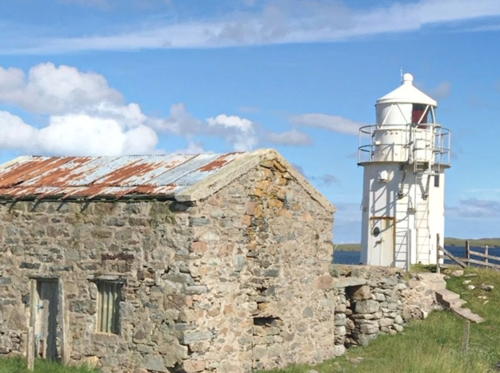
1858 (David and Thomas Stevenson). Active; focal plane 44 m (144 ft); white flash every 20 s. 30 m (98 ft) round masonry tower with lantern and gallery, painted white; lantern painted black. No keeper's house; the keepers formerly lived on the nearby island of Grunay. Anna Jenšíková's photo is at right, Lighthouse Accommodations has a page for the lighthouse, an extreme closeup and a view from the sea are available, Max Gowers has a 2022 photo, Trabas has a distant view by Kees Aalbersberg, and Google has a satellite view. The original shore station was on the neighboring island of Grunay; Google has a satellite view. This light station was strafed by a German submarine in February 1941 but it escaped significant damage. The Out Skerries ("Out" is derived from the Norwegian word øst for "east") are a group of small islands northeast of the main Shetland group. The islands are accessible by a daily ferry. Located on Bound Skerry, a small island at the extreme eastern end of the island group. Accessible only by boat. Site open, tower closed. Operator: Northern Lighthouse Board. ARLHS SCO-164; Admiralty A3807; NGA 3420.

Whalsay Lighthouses
Whalsay ("Whale Island") is an island off the east coast of Shetland Mainland. The island has a permanent population of about 1000, mostly living in the fishing port of Symbister. The island is accessible by passenger ferries from Laxo on Shetland Mainland.

*
Symbister Ness (2)
Date unknown (station established 1904). Active; focal plane 11 m (36 ft); two flashes every 12 s, white or green depending on direction. 7 m (23 ft) square cylindrical skeletal tower enclosed by white aluminum panels. Trabas has a closeup photo by Kees Aalbersberg and Google has a satellite view. Lighthouse Digest has a postcard view of the original lighthouse contributed by Michel Forand. Located at the southwestern point of Whalsay, about 500 m (0.3 mi) west of the harbor of Symbister, the principal town of the island. Site open, tower closed. Operator: Northern Lighthouse Board. ARLHS SCO-235; Admiralty A3802; NGA 3412.
* Suther Ness (2)
Date unknown (station established 1904). Active; focal plane 8 m (26 ft); flash every 3 s, white, red, or green depending on direction. 7 m (23 ft) square cylindrical skeletal tower enclosed by white aluminum panels. Trabas has a photo by Kees Aalbersberg, John Dally has a distant view, and Google has a satellite view. The original lighthouse is on display outside the Musuem of Scottish Lighthouses in Fraserburgh (see the Eastern Scotland page). Located on a low cape sheltering the north side of the harbor at Brough, on the north coast of Whalsay. Island accessible by ferry from Laxo on Shetland Mainland; lighthouse accessible by a short walk. Site open, tower closed. Operator: Northern Lighthouse Board. ARLHS SCO-233; Admiralty A3804; NGA 3416.
Out Skerries Light
Out Skerries Light, Bound Skerry, June 2006
photo copyright Anna Jenšíková; used by permission
[Wether Holm (2)]
2006 (station established 1980). Active; focal plane 6 m (20 ft); white flash every 5 s. 5 m (17 ft) square cylindrical skeletal tower enclosed by white aluminum panels. Trabas has a photo by Kees Aalbersberg and the new tower is seen in Google's satellite view. Located at the northeastern tip of a small island off the north end of the island of West Lingga and about 1.2 km (3/4 mi) west of the Suther Ness Light. Accessible only by boat. Site open, tower closed. Admiralty A3804.2; NGA 3417.

Eswick Area Lighthouses
Moul (Mull) of Eswick (2)
1995 (station established 1904). Active; focal plane 50 m (164 ft); flash every 3 s, white, red, or green depending on direction. 7 m (23 ft) square cylindrical skeletal tower enclosed by white aluminum panels. Robert Sandison has a distant view, Trabas has a distant view by Kees Aalbersberg, Spencer has a photo and Google has a satellite view. The original lighthouse was destroyed when a large section of the cliff collapsed into the sea on 5 November 1994. The site is famous for its spectacular view of the eastern Shetlands. A mull is a cape or promontory. Located on a bluff about 1.2 km (3/4 mi) east southeast of Eswick and 1.6 km (1 mi) north of Hoo Stack. Accessible by road and a short hike. Site open, tower closed. Operator: Northern Lighthouse Board. Admiralty A3796; NGA 3408.
[Hoo Stack]
Date unknown. Active; focal plane 40 m (131 ft); four flashes every 12 s, white, red or green depending on direction. 8 m (26 ft) square cylindrical skeletal tower enclosed by white aluminum panel. Trabas has a photo by Kees Aalbersberg, Spencer has photos and Google has a satellite view. Located atop a small island off the east coast of Shetland Mainland, about 1.5 km (1 mi) southeast of the Moul of Eswick. Accessible only by boat. Site status unknown. Operator: Northern Lighthouse Board. ARLHS SCO-102; Admiralty A3795.7; NGA 3407.

Fair Isle Lighthouses
Fair Isle is an isolated island about 50 km (30 mi) south of Shetland Mainland. The entire island has been owned by the National Trust for Scotland since 1954. Fair Isle is accessible by air from Lerwick on weekdays year round and also on Saturdays in the summer, or by ferry from Sumbergh three times a week in the summer and once a week in the winter. The permanent population is less than 100.

** Fair Isle South (Skadden)
1892 (David A. and Charles Stevenson). Active; focal plane 32 m (105 ft); four white flashes, separated by 2 s, every 30 s. 26 m (85 ft) round masonry tower with lantern and gallery, painted white; lantern painted black. 2-story keeper's quarters and other buildings enclosed by a stone wall. The original Fresnel lens is on display in the National Museum of Scotland in Edinburgh; a Pharos PRB20A rotating beacon is in use. Fog horn (2 blasts every 60 s). Jeroen Minderman's photo is at right, Trabas has an excellent photo, Wikimedia has several photos, Sarah Stout has a fine 2007 photo, Lighthouse Accommodations has a page for the two Fair Isle lighthouses, and Google has a satellite view. Three members of keepers' families were killed at the station during German air raids in 1941-42, and the buildings suffered significant damage. In March 1998 this was the last Scottish lighthouse to be automated. In 2013 the Fair Isle Lighthouse Society was formed to arrange for guided tours of the lighthouse. Located at the southwestern tip of the island; accessible by road. Site open; guided tours available by appointment. Operator: Northern Lighthouse Board. . ARLHS SCO-079; Admiralty A3750; NGA 3312.
Fair Isle South Light
Fair Isle South Light, Fair Isle, May 2006
Flickr Creative Commons photo by Jeroen Minderman
* Fair Isle North (Skroo)
1892 (David A. and Charles Stevenson). Active; focal plane 80 m (262 ft); two white flashes, separated by 2 s, every 30 s. 14 m (46 ft) round cylindrical masonry tower with lantern and gallery, painted white; lantern painted black. 1-story keeper's quarters and other buildings enclosed by a stone wall. Trabas has a great closeup photo, Henning Gieseke has a 2022 photo, Sarah Stout has a fine 2007 photo, Huelse has a historic postcard view, and Google has a satellite view. The station was heavily damaged by two German air raids in the spring of 1941. Located at the northeastern tip of the island; accessible by road. Site open, tower closed. Operator: Northern Lighthouse Board. ARLHS SCO-078; Admiralty A3756; NGA 3316.

Foula Lighthouse
* Foula
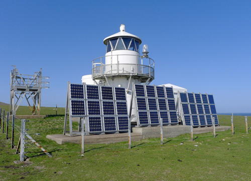
1986. Active; focal plane 36 m (118 ft); three white flashes, separated by 2.7 s, every 15 s. Approx. 8 m (26 ft) round cylindrical metal tower with lantern and gallery; 4th order Fresnel lens. Lighthouse painted white. Julian Paren's photo is at right, Jonathan Osborne has a closeup photo, Trabas has Kees Albersberg's distant view, Lighthouse Accommodations has a page for the lighthouse, and Google has a satellite view. Charles Tait also has a good photo; the large fuel cylinder standing behind the light tower in Tait's photo was removed when the light was solarized in 2000. Foula (from the Norse fuglaey, "bird island") is an isolated island about 40 km (25 mi) west of Shetland Mainland. The permanent population is only about 30, all members of the same family. The island is accessible by ferry, and ecotours and self-catering accommodations are available. Located at the south point of the island; accessible by hiking trail. Site open, tower closed. Operator: Northern Lighthouse Board. ARLHS SCO-085; Admiralty A3860; NGA 3562.

Foula Light, Foula, May 2016
Geograph Creative Commons photo by Julian Paren

Information available on lost lighthouses:

  •  No Ness (1897-1951), Shetland Mainland opposite Mousa. The second (1938) tower was relocated to Perie Bard on Mousa (see above). The masonry foundation is said to survive. ARLHS SCO-150.

Notable faux lighthouses:

  •  

Adjoining page: South: Orkney

Return to the Lighthouse Directory index | Ratings key

Posted September 22, 2004. Checked and revised August 4, 2023. Lighthouses: 32. Site copyright 2023 Russ Rowlett and the University of North Carolina at Chapel Hill.