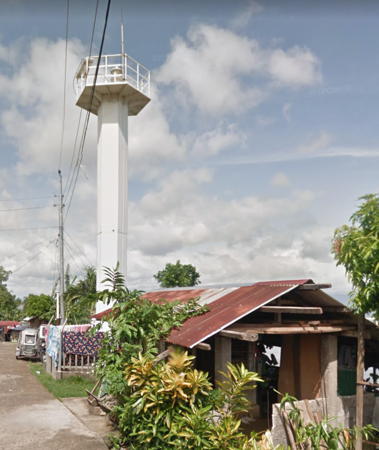
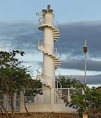
Lighthouses of the Philippines: Southeast Luzon and Catanduanes

The Republic of the Philippines (Pilipinas in Filipino) includes more than 7600 islands stretching over 1750 km (1100 mi) of the western Pacific and separating the Philippine Sea on the east from the South China Sea on the west. The largest islands are Luzon at the northern end of the country and Mindanao at the southern end. As of 2020 the population of the country was about 109 million.

The archipelago was a Spanish colony until the Spanish-American War of 1898, which brought the islands under U.S. administration. Japan occupied the islands during World War II (1942-45) and the country became independent shortly thereafter (1946).

The country is divided into 17 regions and subdivided into 81 provinces. Luzon is the largest island of the country and the northernmost major island. This page lists lighthouses of the southeastern "tail" of Luzon and the neighboring island province of Catanduanes. To the east of the area is the crucial San Bernardino Strait separating Luzon and Samar, the only passage from the Pacific Ocean into the central Philippines. This area comprises 77% of the Bicol Region, which also includes Masbate Province to the south.

Filipino and English are official languages in the Philippines. In Filipino a lighthouses is called a parola; an island is an isla or pulo. Many English maritime terms have been adopted into Filipino, including cape, bay, and port, and the names of historic lighthouses are often retained in their Spanish forms.

Lighthouses in the Philippines are maintained by the Marine Safety Services Command of the Philippine Coast Guard. This area is covered by the Coast Guard District Bicol based at Legazpi. Notices to Mariners are posted by the National Mapping and Resource Information Agency (NAMRIA).

Many Philippine lighthouses are not well known, so better information and photos are always needed.

ARLHS numbers are from the ARLHS World List of Lights. PCG numbers are the Philippines Light List numbers, where known. Admiralty numbers are from volume F of the Admiralty List of Lights & Fog Signals. U.S. NGA List numbers are from Publication 112.

General Sources
Lighthouses in the Philippines
Photos and observations in blog entries by Loyd Martinez.
Online List of Lights - Philippines
Photos by various photographers posted by Alexander Trabas.
Lighthouses in the Philippines
Wikipedia article, with links to articles on several of the individual lighthouses.
Spanish Lighthouses of the Philippines
This is the Directory's own list of the Spanish light stations with notes on their current status.
Lighthouses in the Philippines
Photos by various photographers available from Wikimedia.
World of Lighthouses - Philippines
Photos by various photographers available from Lightphotos.net.
Lighthouses
Photos of Philippines lighthouses by Mike Baylon.
Navionics Charts
Navigational chart information for southeast Luzon.
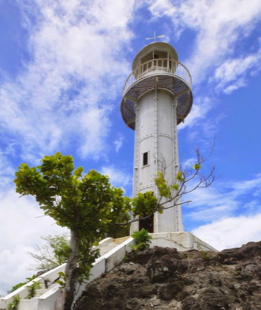

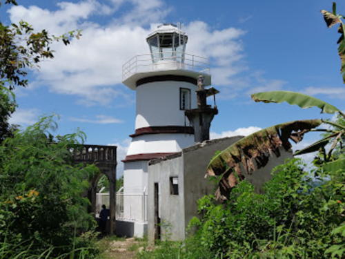
Bagatao Island Light, Sorsogon, April 2015
photo copyright Loyd Martinez; used by permission
Luzon East Coast Lighthouses

Camarines Norte Province Lighthouse
* Capalonga (2?)
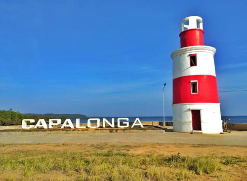
Around 2018. Active; focal plane 10 m (33 ft); listed with red flash every 5 s. 8 m (26 ft) round concrete tower painted with red and white horizontal bands. A photo is at right, another photo (second photo on the page) is available, Ivan Zoren Jueves has a 2021 photo, and Google has a satellite view. Google's 2016 street view shows a smaller light. Located on the waterfront of Capalonga, a town on the northernmost coast of Camarines Norte. Site open, tower closed. Admiralty F2764; NGA 14052.
Tailon (Tunao) Island
1920s. Active; focal plane 18.5 m (60 ft); two white flashes every 10 s. 9 m (30 ft) slender white concrete tower with four buttresses. A closeup photo (third photo on the page) and an aerial photo (second photo on the page) are available and Google has a satellite view. The island is nicknamed Parola (Lighthouse) Island. Located on the western tip of a small island about 8 km (5 mi) north of the northernmost coast of the Bicol Peninsula. Site status unknown. PCG-0123; Admiralty F2766; NGA 14048.
Panganiban
Date unknown. Active; focal plane unknown; white flash every 5 s. Approx. 10 m (33 ft) white fiberglass tower. No photo available but Bing has a satellite view. This light helps guide ships to José Panganiban (formerly Mambulao), a town of about 60,000 residents. Located on the heights of a peninsula projecting into Larap Bay. Site status unknown. PCG-0122; Admiralty F2767; NGA 14050.
* Paracale (2 and 3)
2018. Active; focal plane about 10 m (33 ft); white flash every 5 s. Approx. 10 m (33 ft) white fiberglass tower. Google has a 2019 street view showing the present light standing next to an older concrete post light, but the lights are hard to see in Google's indistinct satellite view. Bing has an older but fuzzy satellite view. Located off the Pulangdaga Road on the northwest side of the village of Paracale. Site open, tower closed. PCG-0124; Admiralty F2769; NGA 14051.

Capalonga Light, Capalonga, December 2019
Facebook photo by Camarines Norte Province
Canimog (Canimo) Island
1927. Active; focal plane 42 m (138 ft); two white flashes every 10 s. 7.5 m (25 ft) slender round white concrete tower with four buttresses. Keeper's house and other station buildings probably in poor condition. Darwin Dalisay has a photo, Frederick Somera has a closeup photo, Joseph Trilles has a 2019 photo, and Google has a satellite view. Located on the northwestern tip of the island, east of Bagaspas Beach. Accessible only by boat. Site status unknown. PCG-0125; Admiralty F2772; NGA 14084.

Camarines Sur Province North Coast Lighthouses
* Cabusao
Date unknown. Active; focal plane 10 m (33 ft); two white (?) flashes every 5 s. Approx. 10 m (33 ft) square pyramidal wood tower surrounding a square concrete pillar. The light was formerly red, as seen in a 2011 photo and a Lightphotos.net extreme 2011 closeup; Google has an indistinct satellite view and a 2016 street view showing the current white light. Located at Cabusao, a port at the south end of San Miguel Bay. Site open, tower closed. PCG-0126; Admiralty F2774; NGA 14088.
* [Sabang (Calabanga, Tarallo)]
Date unknown. Active; focal plane 12 m (39 ft); white flash every 3 s. Approx. 10 m (33 ft) concrete post with gallery. Google has a street view and an indistinct satellite view. Located on the waterfront of Calabanga, a port at the south end of San Miguel Bay about 10 km (6 mi) east of Cabusao. Site open, tower closed. PCG-0532; Admiralty F2775; NGA 14089.
* [Tinambac]
Date unknown. Active; focal plane about 16 m (52 ft); continuous red light. Approx. 12 m (39 ft) concrete post with gallery. Post painted green. Google has a street view and Bing has an indistinct satellite view. Located near the waterfront of Tinambac, a port at on the east side of San Miguel Bay. Site open, tower closed. Admiralty F2775.5; NGA 14090.
Gibgos
Date unknown. Active; focal plane about 15 m (49 ft); white light, pattern unknown. Approx. 10 m (33 ft) white tower, form unknown. No photo available but Google has a satellite view of the area. Located on the waterfront of Gibgos, a village at the south end of Tagun Bay. Site status unknown, probably open. Admiralty F2778.7.
Gata
Date unknown. Active; focal plane unknown; three white flashes every 15 s. Approx. 12 m (39 ft) round barbell-shaped white fiberglass tower. No photo available but Google has a distant satellite view. Located on heights near the southwest end of Lahuy Island. Site status unknown. Admiralty F2778.5; NGA 14093.
Ocata Island
Date unknown (station established 1914). Active; focal plane 38 m (125 ft); white flash every 5 s. 10 m (33 ft) round white concrete tower. No photo available but Google has a very distant satellite view. Located on a small island off Sugar Loaf Point, the northern tip of Lahuy Island. Accessible only by boat. Site status unknown. PCG-0127; Admiralty F2778; NGA 14092.
Guinahoan (Guinahuan, Lahuy, Basot Island)
Date unknown. Active; focal plane unknown; white flash every 5 s. 13 m (43 ft) round barbell-shaped white fiberglass tower. Krislea Viray's photo is at right, Yvette Yang has a 2018 photo, Randy Herher has a 2017 street view, and Google has a distant satellite view. Located on heights near the southeast end of Guinahuan (Basot) Island, off the northeast coast of Lahuy Island. Accessible only by boat. Site open, tower closed. . Admiralty F2776; NGA 14092.3.

Guinahoan Light, Caramoan, August 2017
ex-Google Plus photo by Krislea Viray

Catanduanes Province Lighthouses
Catanduanes is an island province off the southeastern coast of Luzon, separated from the mainland by the Maqueda Channal. The island is about 90 km (55 mi) long from north to south and 50 km (30 mi) wide; its population is about 260,000.
Pandan Point
Date unknown. Active; focal plane 11 m (36 ft) (?); red flash every 5 s. 9 m (30 ft) slender square concrete tower with an external concrete stairway winding around the tower. . The tourist site GoCatanduanes has a photo and Google has an indistinct satellite view. NGA places the light in "Pandan, on beach" but there is no light at the Pandan Beach; the lighthouse is located at a point of land about 1.6 km (1 mi) to the north, near the northern tip of Catanduanes. Site status unknown. PCG-0129; Admiralty F2780; NGA 14116.
Tabugoc
Date unknown. Active; focal plane about 20 m (66 ft); white flash every 5 s. Approx. 10 m (33 ft) round barbell-shaped white fiberglass tower. Google has a satellite view and a distant street view. Located on a promontory on the east side of Tabugoc, on the northeast coast of Catanduanes. Site status unknown. PCG-0133; Admiralty F2782; NGA 14114.
* Lolong Point (Panay Island) (2?)
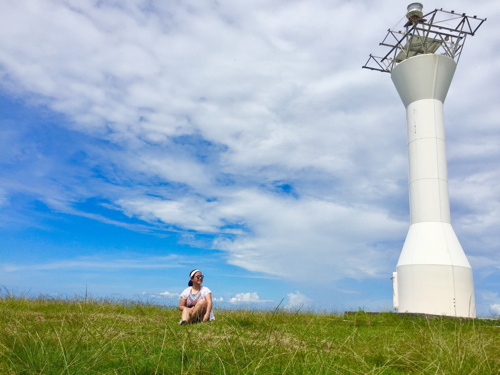
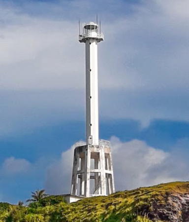
Date unknown. Reactivated (inactive 2006-2014); focal plane 56 m (184 ft); white flash every 5 s. 30 m (99 ft) white concrete tower with two galleries. The building has an enclosed 2-story square base, an octagonal skeletal section topped by a gallery, and then a square cylindrical section topped by the octagonal second gallery. This is a structure of the "Apo Reef" class. John Rex Condeno's 2021 photo is at right, V. Clemente has a 2023 closeup, ARLHS has Marc Capistrano's view from the sea, Dona Lyn also has a view from the sea, and Google has a satellite view. The Municipality of Panganiban calls this tower "the most modern and sophisticated Panay Lighthouse." However, Capistrano reported after a May 2008 visit that the light had lost its keeper in 2006 following a typhoon and had been out of service since. After many appeals by local officials and fishermen, the light was finally restored in May 2014. The lighthouse marks a right-angle turn in the direction of the east coast of the Philippines. Located on Panay Island, a small island off the northeastern corner of Catanduanes province. Accessible only by boat. Site sopen and a stairway leads to the gallery halfway up. . ARLHS PHI-086; Admiralty F2794; NGA 14112.
* Baras
Date unknown. Active; focal plane 21.5 m (70 ft); red flash every 5 s. 9 m (30 ft) round cylindrical concrete post with four buttresses. Lighthouse painted white with blue stripes on the buttresses. A photo is available but the light is barely visible in Google's satellite view. Located on a promontory in Danao, on the east side of Baras Bay across from the town of Baras, on the southeastern coast of Catanduanes. Site open, tower closed. PCG-0134; Admiralty F2790; NGA 14108.


Lolong Point Light, Catanduanes, July 2021
Google Maps photo by John Rex Condeno

Bote
Date unknown. Active; focal plane unknown; two white flashes every 10 s. Approx. 15 m (49 ft) square white concrete tower with a stairway spiraling around the tower. Emanuel Alemania has a 2023 photo, Lemuelle Moninio has a closeup photo, Jay Primo Jayag has a 2019 photo, Randell Sioson has a view from atop the tower, and Google has a satellite view. Located on heights near the village of Bote and the southeastern tip of Catanduanes. Site open and nothing prevents climbing the tower. PCG-0816; Admiralty F2789; NGA 14106.
* Virac
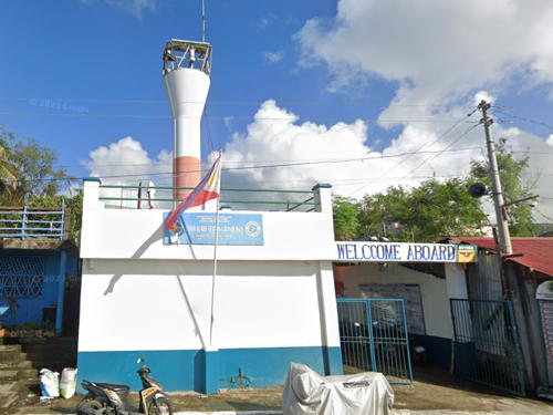
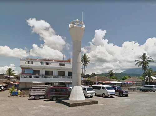
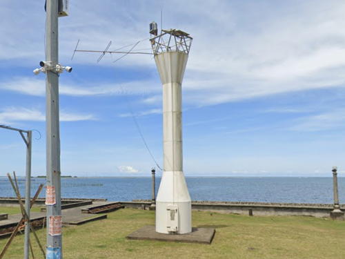
Date unknown. Active; focal plane 12 m (39 ft); red flash every 5 s. 7.5 m (25 ft) round hourglass-shaped fiberglass tower colored white with a red horizontal band and mounted on a square white concrete base. Google has the 2022 street view seen at right but the light is inconspicuous in Google's satellite view of the location. The red band is not seen in a 2013 view from the sea. Virac, the capital city of Catanduanes, is near the south end of the island; the city has population of about 75,000. Located at the Coast Guard station just north of the main pier in Virac. Site open, tower closed. PCG-0132; Admiralty F2788; NGA 14104.
* San Andres (Calolbon)
Date unknown. Active; focal plane 11 m (36 ft); red flash every 10 s. 9 m (30 ft) concrete pillar with a buttressed base, painted with red and white horizontal bands. Raphael Navarro has a 2020 photo and Google has a street view, but the light is inconspicuous in Google's satellite view. Located near the base of the main pier in San Andres (formerly called Calolbon), the port of San Andres and a terminal for ferries from Taboco on Luzon. Site open, tower closed. PCG-0131; Admiralty F2786; NGA 14100.
Sialat Point (2)
Date unknown. Active; focal plane 108 m (354 ft); white flash every 4 s. 10 m (33 ft) tower, described as skeletal by the light lists but listed as concrete by the Coast Guard. No photo available but Google has a distant satellite view. This light guides vessels in the Maqueda Channel, the strait separating Catanduanes from the mainland. Located at the southwestern tip of Catanduanes. Site status unknown. Admiralty F2784; NGA 14096.

Virac Light, Virac, Catanduanes, December 2022
Google Maps street view

Camarines Sur Province East Coast (Lagonoy Bay) Lighthouses
* Colongcogong
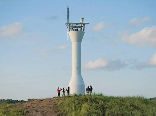
Date unknown. Active; focal plane unknown; white flash every 5 s. Approx. 13 m (43 ft) round barbell-shaped white fiberglass tower. Ronald Kietly O. Conde's photo is at right, anotherphoto is available and Google has a distant satellite view. This light stands on heights near the southeastern end of the Caramoan Peninsula, marking the Caramoan Strait, which separates the mainland of Luzon from the island of Catanduanes and connects Paniman Bay on the north to the Lagonoy Gulf on the south. Accessible by a short walk from nearby resorts. Site open, tower closed. . PCG-0128; Admiralty F2779; NGA 14095.
* Sabang Lagonoy (2?)
Date unknown. Active; focal plane 16 m (52 ft); white flash every 5 s. Approx. 14 m (46 ft) square white concrete tower. Richard Williamson has a photo and Google has an indistinct satellite view. NGA lists a 9 m (30 ft) tower. Located at Sabang, a small port at the mouth of the Lagonoy River. Site probably open, tower closed. PCG-0135; Admiralty F2798; NGA 14120.
Patitinan
Date unknown. Active; focal plane unknown; two white flashes every 5 s. Approx. 9 m (30 ft) round barbell-shaped white fiberglass tower. No photo available and the light has not been found in Google's satellite view. A nearby headland is a possible location. Located on a promontory on the southwest corner of Lagonoy Bay. Site status unknown. PCG-0795; Admiralty F2798.5; NGA 14122.

Albay Province East Coast Lighthouses
* [Malinao Range Front]
Date unknown. Active; focal plane 11 m (36 ft); white flash every 5 s. 7 m (23 ft) square white concrete post. Google has a street view but the slender tower is not seen in Google's satellite view. NGA lists a continuous red light but the street view shows a white light as listed by PCG. The range guides ships through a pass in the reefs extending northwest of San Miguel Island. Located about 100 m (330 ft) fro the beach in Baybay. Site open, tower closed. PCG-0138; Admiralty F2802; NGA 14124.

Colongcogong Light, Caramoan, February 2019
Instagram photo by Ronald Kietly O. Conde
* Malinao Range Rear
Date unknown. Active; focal plane 18 m (60 ft); white flash every 5 s. 7 m (23 ft) square concrete post rising from a small concrete equipment cabinet; a stairway spirals around the post. Google has a closeup street view but the small light is inconspicuous in Google's satellite view. Located in a right-angle bend of Rayan Nabor street in Malinao, a city of about 50,000 residents facing the upper end of Tabaco Bay; this is about 1.2 km (3/4 mi) west southwest of the front light. Site open and the tower could be climbed. PCG-0137; Admiralty F2802.1; NGA 14128.
* Bacacay (2)
Date unknown. Active; focal plane about 10 m (33 ft); white flash every 5 s. Approx. 9 m (30 ft) round barbell-shaped white fiberglass tower. A photo by Rick Bermundo (a little over halfway down the page) is available. Google has a 2022 street view (a portion of a 2016 street view is seen at right) and a distant satellite view. Another 2022 street view shows the previous post light. Located at the base of the pier in Bacacay, a fishing and resort town at the south end of Tabaco Bay. Site open, tower closed. PCG-0660; Admiralty F2813; NGA 14129.4.
Rawis (San Miguel Island)
2009(?). Active; focal plane about 15 m (49 ft); two green flashes every 4 s. Approx. 10 m (33 ft) round barbell-shaped white fiberglass tower. No photo available but Google has a distant satellite view. Note: There is another San Miguel Island Light in Masbate. Located at the northwestern tip of San Miguel, an island off the south coast of the Lagonoy Gulf. Site status unknown. PCG-0136; Admiralty F2800; NGA 14129.
Labcan Point
Date unknown. Active; focal plane unknown; white light, 2 s on, 2 s off. Approx. 10 m (33 ft) round hourglass-shaped white fiberglass tower. No photo available but Google has a fuzzy satellite view. Located on a headland on the north side of Batan Island, apparently marking the entrance to a harbor of refuge. Site status unknown. Admiralty F2809.5; NGA 14130.
Ungay Point (2)
Date unknown (station established 1911). Active; focal plane 94 m (307 ft); white flash every 7 s. 10 m (33 ft) round aluminum tower, according to the Coast Guard. No photo available, but Google has a satellite view. The original lighthouse was concrete. This lighthouse marks the entrance to the Albay Gulf leading to the seaport of Legazpi, the largest city of southeastern Luzon. Environmentalists are protesting mining operations in the area (without success, it appears). Located at the eastern end of Rapu-Rapu Island. Site status unknown. ARLHS PHI-064; PCG-0140; Admiralty F2808; NGA 14136.

Bagacay Light, Albay, July 2016
Google Maps street view
Cabadea Point (Port Sula) (2)
2020(?). Active; focal plane 16 m (52 ft); red flash every 5 s. PCG and NGA describe this light as a 2 m (7 ft) concrete post but Google's satellite view shows a larger structure, probably a fiberglass tower. No photo available. Located on a point on the north side of Albay Gulf, marking the entrance to an inlet leading to the town of Port Sula. Site status unknown. PCG-0141; Admiralty F2810; NGA 14132.
Legazpi (Legaspi) (3?)
2015 (station established 1904). Active; focal plane 18 m (59 ft); red flash every 5 s. 16 m (52 ft) white barbell-shaped fiberglass tower. No photo available but Google has a distant street view and the tower is centered in a 2022 drone view and in Google's indistinct satellite view. Much better known in Legazpi is a tall faux lighthouse on the Embarcadero downtown. Legazpi, the capital of the Bicol Region, has a population of nearly 200,000. Located in a crowded urban area north of downtown Legazpi and south of the Tibu River. Site status unknown. PCG-0142; Admiralty F2814; NGA 14140.

Sorsogon Province East Coast and San Bernardino Strait Lighthouses
Sorsogon is the southeasternmost province of Luzon, occupying the extreme tip of the Bicol Peninsula.

* Prieto Diaz (Diamante)
Date unknown. Active; focal plane about 12 m (39 ft); white flash every 6 s. 10 m (33 ft) round hourglass-shaped white fiberglass tower. Google has a 2022 street view but trees hide the light in Google's satellite view. Located on the waterfront of Prieto Diaz, a small port in northeastern Sorsogon. Site open, tower closed. PCG-0143; Admiralty F2809; NGA 14138.
* Port Gubat
Date unknown (station established 1911). Active; focal plane 12 m (39 ft); white flash every 5 s. 10 m (33 ft) round metal tower with gallery painted white. Nestor Castillo has a drone view and Google has a street view of the top of the tower and a fuzzy satellite view. Located off Burgos Street at the north end of Gubat, a city of about 60,000 residents. Site open, tower closed. PCG-0144; Admiralty F2818; NGA 14144.
* Barcelona
Date unknown. Active; focal plane about 13 m (43 ft); white flash every 10 s. Approx. 10 m (33 ft) round hourglass-shaped white fiberglass tower. Google's 2022 street view is at right, Jay Quil has a photo, a closeup (3/4 the way down the page) and another photo (halfway down the page) are available, and Google also has a satellite view. Located near the ruins of a Spanish fort on the south side of Barcelona, a small port on the extreme east end of Sorsogon. Site open, tower closed. PCG-0145; Admiralty F2818.4; NGA 14145.

Barcelona Light, Sorsogon, September 2022
Google Maps street view
San Bernardino Island
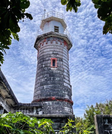
1896 (Spanish: Guillermo Brockman). Active; focal plane 41 m (136 ft); white flash every 10 s. 12 m (39 ft) granite block tower with gallery, painted white. Sibling of the Capul Island lighthouse. The original lantern and 3rd order Fresnel lens were removed in the late 1990s. They were replaced by an extension of the tower with a second gallery and the light mounted on a mast. The extension is painted white; the original tower, originally unpainted, is now also white. 1-story keeper's houses in ruins. A 2022 photo is at right Jack Evasco has a 2013 photo, he also has a drone view, Jernel Patena has a photo, a 2020 closeup is available, and Google has a satellite view. The lighthouse was not operating when Loyd Martinez visited in July 2015. Located atop a small island at the eastern entrance to San Bernardino Strait, the passage into the central Philippines between the islands of Luzon and Samar. Accessible only by boat. Site open, tower closed. . ARLHS PHI-052; PCG-0104; Admiralty F2488; NGA 14148.
Santa Magdalena (Balusingan Bay)
Date unknown. Active; focal plane unknown; two white flashes every 10 s. Approx. 12 m (39 ft) round hourglass-shaped white fiberglass tower. Google has a distant street view and an indistinct satellite view. Santa Magdalena is a small port facing the north end of the San Bernardino Strait. Located on a steep bluff behind the town. Site status unknown. PCG-0103; Admiralty F2547; NGA 14150.
Calantas Rock
Date unknown. Inactive but listed with focal plane 10 m (33 ft); red flash every 5 s. 10 m (33 ft) concrete post with a pyramidal base mounted on a square concrete pier. Ramoncito Landayan's 2015 photo shows the light abandoned; PCG reported it active in 2017 but it is still abandoned in Mike McCusker's 2019 photo. The reef is only a blur in Google's satellite view. Located on a reef in the San Bernardino Strait, the passage into the central Philippines between the islands of Luzon and Samar, about 5 km (3 mi) off the southernmost tip of Luzon and 10 km (6 mi) northwest of Capul Island. Accessible only by boat. Site open, tower closed. PCG-0102; Admiralty F2494; NGA 14156.

San Bernardino Island Light, Biri, July 2022
instagram photo by Marco Paulo Real Pajares

Luzon West Coast Lighthouses

Sorsogon Province West Coast Lighthouses
* Bulan
Date unknown. Active; focal plane 10 m (33 ft); red flash every 5 s. 8.5 m (28 ft) square concrete post with a stairway winding around it. A photo (last photo on the page) is available and Google has a street view, but the slender tower is not seen in Google's satellite view of the location. Bulan, a town on the west side of Sorsogon, is the terminal for ferries crossing the Ticao Pass to Masbate. Located near the foot of the ferry pier in Bulan. Site open, tower closed. PCG-0101; Admiralty F2546; NGA 14160.
Bagatao Island
1904. Active (?); focal plane 41 m (135 ft); white flash every 5 s. 9 m (29 ft) tourelle steel tower with octagonal lantern and gallery, painted white. Keeper's houses demolished. The photo by Loyd Martinez at the top of this page is from his visit in April 2015, Celeste Salala has a 2017 closeup photo, Clement Rasul has a 2021 photo, and Google has an indistinct satellite view of the station. The lighthouse looked abandoned in a 2014 photo but it was painted and refurbished before Martinez's visit in April 2015. The lighthouse was ordered by Spanish authorities and prefabricated in France; it was one of several such lighthouses installed by the U.S. early in its administration. Now it is the only representative of this group still in service. The government of Magallanes is working to preserve the station and develop it as a tourist attraction. Located at the eastern end of the island, in the entrance to the Bay of Sorsogon west of Magallanes. The island is accessible by passenger ferry from Magallanes. Site open, tower closed. . PCG-0097; ARLHS PHI-006; Admiralty F2536; NGA 14164.
Bagatao Island Northwest (2)
Date unknown. Active; focal plane about 17 m (56 ft); red flash every 5 s. Approx. 11 m (36 ft) octagonal tower with lantern and gallery, painted white with black trim. A 2022 photo is at right and Google has a satellite view. This light replaced a 7 m (23 ft) round concrete tower;in the photo it is seen, painted black, in front of the new lighthouse. Located about 500 m (0.3 mi) north of the historic lighthouse. PCG-0098; Admiralty F2538; NGA 14168.

Bagatao Island Northwest Light, Sorsogon, March 2022
Google Maps photo by pick ka chu
* Casiguran
Date unknown. Active; focal plane 21 m (69 ft); white flash every 5 s. 10 m (33 ft) slender hexagonal white concrete tower with gallery. A 2016 Google street view is at right, Cesar C. Cambay has a closeup photo and Google has a 2023 street view and a satellite view. Located east of the pier in Casiguran, a town on the southeast side of Sorsogon Bay. Site open, tower closed. PCG-0100; Admiralty F2544; NGA 14172.
* [Castilla]
Date unknown. Active; focal plane 15 m (49 ft); red flash every 5 s. 10 m (33 ft) white concrete post with four buttresses. No photo available but Bing has an indistinct satellite view. Located at Castilla, a fishing port on the northwest side of Sorsogon Bay. Site open, tower closed. PCG-0099; Admiralty F2540; NGA 14176.
Macalaya
Date unknown. Active; focal plane unknown; two white flashes every 10 s. Approx. 9 m (30 ft) barbell-shaped white fiberglass tower. No photo available but Bing has a satellite view. Located on a promontory about 800 m (1/2 mi) southeast of Macalaya, a fishing port on a northwestern embayment of Sorsogon Bay. Site status unknown. PCG-0096; Admiralty F2535.5; NGA 14169.
Port Putiao (Pilar, Quidavid Point)
Date unknown. Active; focal plane unknown; three green flashes every 3 s. 10 m (33 ft) barbell-shaped white fiberglass tower. No photo available but Google has a satellite view. Located on a forested promontory on the west side of the bay of Putiao. Site status unknown. PCG-0095; Admiralty F2535; NGA 14170.
Donsol
Date unknown. Active; focal plane 11 m (36 ft); red flash every 5 s. 10 m (33 ft) concrete tower. Google has a 2022 street view but the tower is hard to spot in Google's satellite view. Located on the east side of the entrance to the Ubod River in the town of Donsol. Site status unknown. PCG-0094; Admiralty F2534; NGA 14180.

Casiguran Light, Sorsogon, October 2016
Google Maps street view

Albay Province South Coast Lighthouse
Cabarian Point
Date unknown. Active; focal plane 46 m (151 ft); white flash every 10 s. 10 m (33 ft) white barbell-shaped fiberglass tower. No photo available but Google has an indistinct satellite view. This light marks the narrowest point of the Burias Pass, the passage between Burias Island and the mainland of Luzon. Located on the point about 2.5 km (1.5 mi) southwest of the village of Cabarian. Site status unknown. PCG-0627; Admiralty F2503.8; NGA 14182.

Camarines Sur Province South Coast (Ragay Gulf) Lighthouses
Laganac (Balatan North)
Date unknown. Active; focal plane unknown; three white flashes every 10 s. 10 m (33 ft) white barbell-shaped fiberglass tower. No photo available and the light has not been found in Google's satellite view. Located on heights about 4 km (2.5 mi) north of Balatan, a town of about 30,000 residents. Site status unknown. Admiralty F2504; NGA 14134.
Bagoboso (Salingogon, Bagalatao)
Date unknown. Active; focal plane unknown; white flash every 5 s. Approx. 10 m (33 ft) white barbell-shaped fiberglass tower. No photo available and the light has not been found in Google's satellite view. Located on the west side of Bagalatao on the north side of Ragay Gulf. Site status unknown. PCG-0090; Admiralty F2504.5; NGA 14134.5.
Pasacao (modified)
Date unknown. Active; focal plane about 25 m (82 ft); white flash every 5 s. This was a 10 m (33 ft) white barbell-shaped fiberglass tower but Google's 2023 street view shows the top of the tower replaced by a short mast. Google also has a satellite view. Located on a forested slope on the west side of the entrance to the harbor of Pasacao, a city of about 50,000 residents on the north side of Ragay Gulf. Site status unknown. PCG-0089; Admiralty F2505; NGA 14135.
Kilbay Point
Date unknown. Active; focal plane 12 m (39 ft); white flash every 5 s. 10 m (33 ft) round white concrete tower with a stairway spiraling around the tower. Jaiven Jay Cañete's 2023 closeup photo is at right and Google has a satellite view. Located at the end of a long spit projecting into the head of Ragay Gulf. Accessible only by boat. Site open, tower closed. Admiralty F2505.2.
 

Kilbay Point Light, Camarines Sur, April 2023
Google Maps photo by Jaiven Jay Cañete
 

Information available on lost lighthouses:

Notable faux lighthouses:

Adjoining pages: North: Northeast Luzon | Southeast: Samar | South: Masbate | West: Southwest Luzon

Return to the Lighthouse Directory index | Ratings key

Posted July 24, 2005. Checked and revised October 29, 2023. Lighthouses: 48. Site copyright 2023 Russ Rowlett and the University of North Carolina at Chapel Hill.