Lighthouses of the Philippines: Masbate

The Republic of the Philippines (Pilipinas in Filipino) includes more than 7600 islands stretching over 1750 km (1100 mi) of the western Pacific and separating the Philippine Sea on the east from the South China Sea on the west. The largest islands are Luzon at the northern end of the country and Mindanao at the southern end. As of 2020 the population of the country was about 109 million.

The archipelago was a Spanish colony until the Spanish-American War of 1898, which brought the islands under U.S. administration. Japan occupied the islands during World War II (1942-45) and the country became independent shortly thereafter (1946).

The country is divided into 17 regions and subdivided into 81 provinces. This page describes lighthouses of Masbate Province, which includes the islands of Masbate, Ticao and Burias and associated smaller islands. These islands are located south of Luzon's southeastern Bicol Peninsula and northwest of Samar. Geographically they lie to the north of the islands known as the Visayas. Administratively they are grouped with southeast Luzon within the Bicol Region.

Filipino and English are official languages in the Philippines. In Filipino a lighthouses is called a parola or farola; an island is an isla or pulo. Many English maritime terms have been adopted into Filipino, including cape, bay, and port, and the names of historic lighthouses are often retained in their Spanish forms.

Lighthouses in the Philippines are maintained by the Marine Safety Services Command of the Philippine Coast Guard. Notices to Mariners are posted by the National Mapping and Resource Information Agency (NAMRIA).

Many Philippine lighthouses are not well known, so better information and photos are needed.

ARLHS numbers are from the ARLHS World List of Lights. PCG numbers are the Philippines Light List numbers, where known. Admiralty numbers are from volume F of the Admiralty List of Lights & Fog Signals. U.S. NGA List numbers are from Publication 112.

General Sources
Lighthouses in the Philippines
Photos and observations in blog entries by Loyd Martinez.
Online List of Lights - Philippines
Photos by various photographers posted by Alexander Trabas.
Lighthouses in the Philippines
Wikipedia article, with links to articles on several of the individual lighthouses.
Spanish Lighthouses of the Philippines
This is the Directory's own list of the Spanish light stations, with notes on their current status.
Lighthouses in the Philippines
Photos by various photographers available from Wikimedia.
World of Lighthouses - Philippines
Photos by various photographers available from Lightphotos.net.
Lighthouses
Photos of Philippines lighthouses by Mike Baylon.
Navionics Charts
Navigational chart information for Masbate.

Jintotolo Light, Masbate, June 2015
ex-Google Plus photo by Jernel Patena
Burias and Ticao Lighthouses

Burias Lighthouses
Burias is an island located northwest of Masbate. The island is oriented northwest to southeast and is nearly 80 km (50 mi) long but no more than 25 km (15 mi) wide. On its north side the Burias Pass separates Burias from southeast Luzon, while its south side faces the Sibuyan Sea. The island's population is a little less than 90,000. There is ferry service from Pio Duran in Albay Province, Luzon, to Clavaria on the north coast of Burias.

Ajuga (Ajoga) Point
2008. Active; focal plane about 22 m (72 ft); three white flashes every 10 s. Approx. 10 m (33 ft) round barbell-shaped white fiberglass tower. No photo available but Google has a distant satellite view. Located at the southeastern tip of Burias Island. Site status unknown. Admiralty F2503; NGA 14602.
Malapingan (Bagasiong Point)
2008. Active; focal plane about 22 m (72 ft); white flash every 5 s. Approx. 10 m (33 ft) round barbell-shaped white fiberglass tower. No photo available but Google has a satellite view. Located on a headland on the south side of Burias Island, about 30 km (19 mi) northwest of Ajuga Point. Site status unknown. PCG-0093; Admiralty F2503.2; NGA 14602.5.
San Pascual
2008(?). Active; focal plane unknown; white flash every 10 s. Approx. 10 m (33 ft) round barbell-shaped white fiberglass tower. No photo available but Google has a satellite view. Located on a promontory at the northwestern corner of Burias, guiding vessels to the port of San Pascual. Site status unknown. PCG-0091; Admiralty F2503.5; NGA 14603.

Ticao Area Lighthouses
Ticao is located north of Masbate. Like Burias the island is oriented northwest to southeast; it is nearly 50 km (30 mi) long but no more than 15 km (8 mi) wide. On the east side the Ticao Pass separates Ticao from Luzon and on the west side the Masbate Pass separates Ticao from Masbate. The Southern Passage, the main shipping route through the central Philippines to Manila, passes through the Ticao Pass and then around the north end of Ticao into the Sibuyan Sea. The population of the island is about 95,000. There is ferry service across the Masbate Pass from Masbate City to Lagundi, Ticao.

San Miguel Island (Tikao Island, Ticao Island)
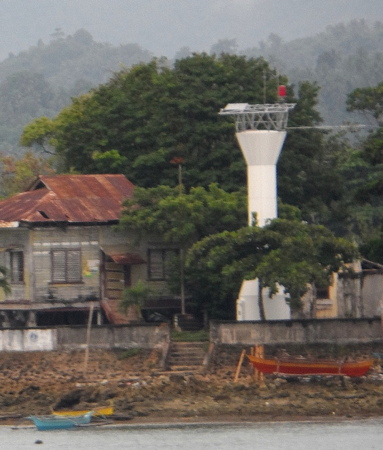
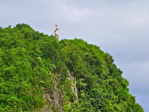
1907. Active; focal plane 68 m (223 ft); three white flashes every 15 s. 11 m (36 ft) slender square concrete tower with an external concrete stairway winding around the tower. A distant view is seen at right and Google has a satellite view of the station. This relatively modest light is an important waymark for ships sailing the Southern Passage. Note: There is another San Miguel Island Light in Albay (see the Southeast Luzon page). Located on a small island at the end of a ridge extending from the northwestern tip of Ticao. Accessible only by boat. Site status unknown. ARLHS PHI-054; PCG-0195; Admiralty F2502; NGA 14612.
* Port San Jacinto
Date unknown (station established 1908). Active; focal plane 17 m (56 ft); red flash every 5 s. 8 m (26 ft) round cylindrical white concrete tower. Bhonts Bartolata has a photo but the tower is inconspicuous in Google's satellite view of the port. Located at the east end of the waterfront of San Jacinto, a port on the north side of Ticao. Site probably open, tower closed. PCG-0196; Admiralty F2500; NGA 14620.
Matabao Island (Argos Point) (2)
Date unknown (station established 1907). Active; focal plane 32 m (105 ft); white flash every 5 s. 10 m (33 ft) round white concrete tower. No photo available but Google has a satellite view of the station. It is possible that the original lighthouse, a "concrete house," also survives here. Located at the southeastern end of Matabao, where it marks the north side of the southern entrance to the channel between Masbate and Ticao. Accessible only by boat. Site status unknown. ARLHS PHI-005; PCG-0197; Admiralty F2498; NGA 14616.

San Miguel Island Light, Monreal, Ticao
unattributed Monreal tourist development photo

Masbate Lighthouses

Shaped like a letter L flipped 90° clockwise, the island of Masbate has a population of more than 700,000. Its north coast faces the Masbate Pass and the northern extension of the Samar Sea; the south coast faces the Visayan Sea, and the west coast faces the Sibuyan Sea.

North Coast Lighthouses
Colorada Point
1908. Active; focal plane 33 m (109 ft); two red flashes every 5 s. 5 m (16 ft) slender square concrete tower with an external concrete stairway winding around the tower. A closeup photo is available and Google has an indistinct satellite view. There may have been a Spanish light at this location, but the present lighthouse is American. NGA mentions a keeper's cottage but only foundation ruins survive. Located on the west side of the entrance to the harbor of Aroroy, on the north coast of Masbate. Probably accessible only by boat. Site apparently open, tower status unknown. ARLHS PHI-020; Admiralty F2508; NGA 14604.
#Masbate Harbor (1)
Date unknown. Inactive; apparently demolished sometime between 2011 and 2013. This was a 13 m (43 ft) square skeletal tower, mounted on a 1-story building. The tower was painted with red and white horizontal bands. A 2011 photo shows this tower behind its replacement. Located close to the modern lighthouse (next entry).
* Masbate Harbor (2)
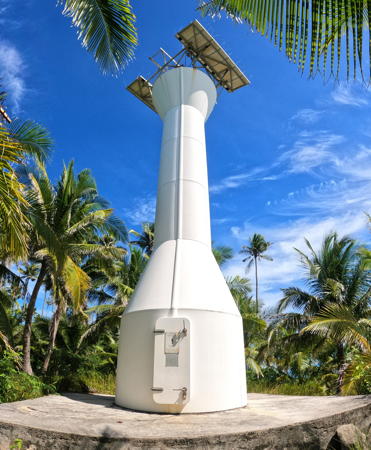
Date unknown. Active; focal plane 16 m (52 ft); red flash every 5 s. 13 m (43 ft) round barbell-shaped fiberglass tower. Entire lighthouse is white. Mike Baylon's photo is at right, Roland Tamayo has a closeup photo, a third photo is available, and Google has a satellite view. Located on the waterfront opposite Masbate City. Site open, tower closed. PCG-0194; Admiralty F2506; NGA 14607.
Matayum
Date unknown. Active; focal plane about 12 m (39 ft); two white flashes every 10 s. Approx. 10 m (33 ft) round white barbell-shaped fiberglass tower. A YouTube video of new resort development in the area shows the lighthouse at the 1:30 mark. The development was built around the light, which does not seem to have moved as a result. Neither the development nor the lighthouse are seen in Google's satellite view but the lighthouse is seen in its former context in Bing's older satellite view. Located at the end of the Matayum Peninsula, which shelters the harbor of Cataingan in southeastern Masbate. Site status unknown. Admiralty F2505.6.

Masbate Harbor Light, Masbate, September 2013
Flickr photo copyright Mike Baylon; premission requested
Caduruan Point (Rizal)
2007(?). Active; focal plane unknown; two white flashes every 10 s. Approx. 10 m (33 ft) round barbell-shaped white fiberglass tower. J.M. Nga has the Facebook photo seen at right as well as a video and Google has a distant satellite view. Located at the southeastern tip of Masbate Island. Site status unknown. Admiralty F2293.87 (ex-F2505.5); ex-NGA 14606.

South Coast (Visayan Sea) Lighthouses
Guinauayan Island
Date unknown. Active; focal plane unknown; two white flashes every 10 s. Approx. 12 m (39 ft) round barbell-shaped white fiberglass tower. No photo available but Google has a distant satellite view. Located on heights on the southwest side of Guinauayan Island, about 5 km (3 mi) south of Placer. Accessible only by boat. Site status unknown. Admiralty F2293.85; NGA 14623.55.
Cawayan (?)
Date unknown. Active; focal plane unknown; green flash every 5 s. No description available. No photo available and the lighthouse has not been found in Google's satellite view of the location listed by PCG. Cawayan is a village on the southeast coast of Masbate. The indicated location is at a ferry pier west of the town (ferries connect Cawayan to Palumbato, Cebu). Although there is a 2013 PCG Notice to Mariners referencing the light Google's 2016 street view of the pier does not show a light. Site status unknown. Admiralty F2293.8; NGA 14623.5.
Naro Island (Punta Batsan)
Date unknown. Active; focal plane about 15 m (49 ft); green flash every 5 s. Approx. 12 m (39 ft) round barbell-shaped white fiberglass tower. No photo available but the lighthouse can be seen in the center of Bing's satellite view. Naro is an inhabited island about 5 km (3 mi) off the coast of Masbate near Cawayan. Located in the village of Punta Batsan near the south end of the island. Site status unknown. PCG-0695; Admiralty F2293.9 (ex-F2296.5).
* Calasuche (Milagros)
Date unknown. Active; focal plane about 12 m (39 ft); two red flashes every 4 s. Approx. 10 m (33 ft) round barbell-shaped white fiberglass tower. No photo available but Google has a satellite view. Milagros is a municipality of about 60,000 residents at the head of the Asid Gulf, the bay separating the two "arms" of the L-shaped Masbate Island. Located on the east side of the entrance to the Milagros estuary and the town of Calasuche. Site open, tower closed. Admiralty F2293.5; NGA 14623.

Caduruan Point Light, Masbate, March 2022
Facebook photo by JM Nga VLOGS; used by premission

West Coast (Sibuyan Sea) Lighthouses
* Jintotolo (Gintotolo) Island
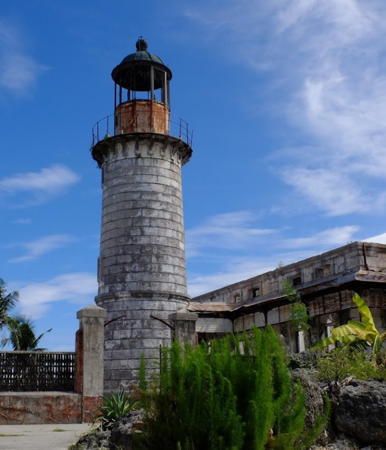
1895 (Spanish: Ramon de Ros). Active; focal plane 57 m (187 ft); three white flashes every 10 s. 15.5 m (51 ft) square cylindrical stone tower with lantern and gallery. 1-story keeper's house. Jernel Patena's photo is at the top of this page, Joshua Briones has a 2022 photo, Michael Denne has a 2011 photo, visitors with three dogs have a 2021 photo, and Google has a satellite view. This historic lighthouse has been restored and is in good condition. Located on an island off the southwestern tip of Masbate in the Jintotolo Strait, an important shipping route to and from the central Philippines. Accessible only by boat. Site status unknown. . ARLHS PHI-035; PCG-0637; Admiralty F2292; NGA 14624.
Pulanduta Point
Date unknown. Active; focal plane unknown; two white flashes every 4 s. Approx. 10 m (33 ft) round barbell-shaped white fiberglass tower. No photo available but Google has a satellite view. Located on the southwestern tip of the mainland of Masbate. Site status unknown. PCG-0188; Admiralty F2293; NGA 14622.
Pagbulungan Point (Guincaipatan)
Date unknown. Active; focal plane unknown; green flash every 5 s. Approx. 10 m (33 ft) round barbell-shaped white fiberglass tower. A photo is available, Joel Quilang has a distant 2021 view (lighthouse in upper left corner), and Google has a satellite view. Located on a promontory on the souther top of Guincaipatan Island marking the north side of the entrance to Nin Bay and the harbor of Mandaon on the central west coast of Masbate. Site status unknown. PCG-0187; Admiralty F2292.5; NGA 14598.
* Bugui Point (1)
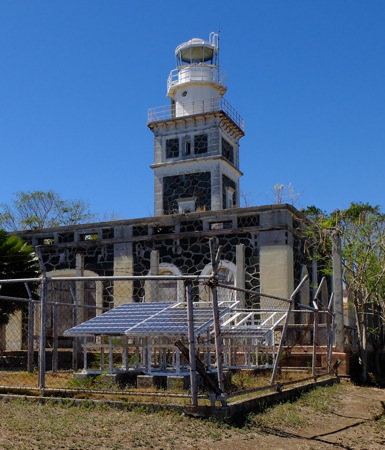
1903 (Spanish/U.S.). Inactive. 15 m (49 ft) masonry tower. Keeper's house. Jernel Patena has the 2015 photo at right, Jorin Manansala has a 2022 photo, Neil Almero has a photo, and Google has a satellite view of the station. Spanish authorities began construction of the lighthouse in 1893 but work was suspended in 1896. The Americans completed the lighthouse and activated it. Endangered. The lighthouse has been abandoned and is clearly deteriorating; the tower is in poor condition and the roof of the keeper's house has collapsed. Loyd Martinez visited in April 2015 and found the condition of the lighthouse "disheartening." Located at the northwestern point of Masbate, a landmark on the traditional Southern Passage to Manila from San Bernardino Strait. Site apparently open, tower apparently open but probably dangerous. . ARLHS PHI-070.
* Bugui Point (2)
Date unknown (station established 1903). Active; focal plane 66 m (218 ft); three white flashes every 10 s. Approx. 15 m (49 ft) white round cylindrical tower with flared top. Aaron Vicencio has a photo of the station and Jorin Manansala has a 2022 photo showing both lighthouses. Located next to the historic lighthouse. PCG-0186; Admiralty F2510; NGA 14600.

1903 Bugui Point Light, Masbate, June 2015
Google Maps photo by Jernel Patena

Information available on lost lighthouses:

Notable faux lighthouses:

Adjoining pages: North: Southeast Luzon | East: Samar | Southeast: Leyte and Biliran | South: Cebu | Southwest: Panay and Guimaras | West: Mindoro and Romblom Area

Return to the Lighthouse Directory index | Ratings key

Posted July 24, 2005. Checked and revised November 5, 2023. Lighthouses: 20. Site copyright 2023 Russ Rowlett and the University of North Carolina at Chapel Hill.