Lighthouses of Poland: Odra River

The Republic of Poland (Polska in Polish) is located to the south of the Baltic Sea between Germany and Belarus. Poland has a long history but in the last decades of the 1700s it lost its independence, partitioned in several stages by its then-neighbors Prussia, Russia, and Austria. Following World War I the 1919 Treaty of Versailles restored Poland's independence but gave the country only a small section of coastline at Gdynia. At the end of World War II in 1945 Poland's borders were shifted westward, reducing the size of the country but granting it a substantial coastline removed from the defeated Germany.

Since the end of World War II in 1945 the coast of Poland has stretched from Świnoujście in the west to the Gulf of Gdansk in the east. Poland has at least 26 lighthouses on its Baltic coast and also many lighthouses on the inland waterway that extends from Świnoujście to Szczecin. This page lists the lighthouses of the Odra (Oder) River leading from the Szczecin Lagoon to Szczecin. Lighthouses of the northern portion of the waterway are described on the Świnoujście Area page.

Poland is divided into 16 provinces called voivodeships (województwa), and the voivodeships are subdivided into powiats (counties) and gminas (municipalities). All the lighthouses of this page are in the voivodeship of West Pomerania (Zachodniopomorskie). West Pomerania became part of Prussia in 1720 and thus part of the German Empire when it was formed in 1871. As a result nearly all the lighthouses in the region were built under German administration. The German names of these lighthouses are shown in curly brackets {}.

Szczecin (known as Stettin under German rule) is located on the Odra (Oder) River more than 50 km (30 mi) from the sea. The Odra empties into Szczecin Bay (Zalew Szczeciński in Polish or Stettiner Haff in German), a large lagoon that in turn empties into the Baltic through three channels. The western end of the bay and the westernmost of the three channels lie in Germany. Large ships enter the waterway through the central channel, the Świna, at Świnoujście (Swinemünde). Today Szczecin is Poland's largest port, but until World War II it was Germany's third largest port.

In Polish a lighthouse is a "sea lantern," latarnia morska, plural latarnie morskie. Wyspa is an island, płycizna is a shoal, zatoka is a bay, zalew is a lagoon, cieśnina is a strait, rzeka is a river, falochron is a breakwater, and molo is a pier. The Baltic Sea is called the Morze Bałtyckie in Polish.

Active Polish lighthouses are operated by the regional Maritime Office (Urząd Morski). Previously there were three of these offices, in Szczecin, Słupsk, and Gdynia. In 2020 the Słupsk office was closed and its duties transferred to the Gdynia office. All of the lights on this page are managed by the Szczecin Maritime Office (Urząd Morski w Szczecinie).

ARLHS numbers are from the ARLHS World List of Lights. Light List numbers are from volume C of the Admiralty List of Lights & Fog Signals. U.S. NGA List numbers are from Publication 116.

General Sources
Polnische Leuchttürme
Photos posted in 2005 by Klaus Huelse, including many photos of the inland lighthouses.
Baken Swinemünde
Photos and historical accounts by Gerd Liedtke.
Online List of Lights - Poland - Zatoka Pomorska
Photos by various photographers posted by Alexander Trabas.
Leuchttürme an der polnischen Küste
Photos by Bernd Claußen.
Min Blinkfüer
Photos and accounts in German of German and Polish lighthouses.
Lighthouses in Poland
Photos by various photographers available from Wikimedia.
World of Lighthouses - Poland
Photos by various photographers available from Lightphotos.net.
Poland
Historic postcard views posted by Michel Forand.
Leuchttürme der ehemaligen deutschen Ostgebiete
Postcard views of historical German lighthouses in Poland and other former German Baltic territories, posted by Klaus Huelse.
GPSNauticalCharts
Navigational chart for the Szczecin area.
Navionics Charts
Navigational chart for the Szczecin area.


Brama Torowa 4W, Trzebież, May 2018
Google Maps photo by Waldemar Olesniewicz
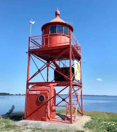

Chełminek South Light, Goleniów County, August 2018
Googel Maps photo by Krzysiek Ż

Police and Goleniów Counties Lighthouses

Police County (Powiat policki) occupies the left (west) side of the Odra River and Goleniów County (Powiat goleniowski) occupies the east side.

Trzebież and Chełminek (Roztoka Odrzańska) Area Lighthouses
As it empties into the Zalew Szczeciński, the Odra River widens in a basin known in Polish as the Roztoka Odrzańska or in German as the Papenwasser.

Chełminek North {Leitholm Nord} (2)
1912 (station established 1890). Active; focal plane 13 m (42 ft); red light occulting twice every 8 s, synchronized with the south end light. 13 m (42 ft) square cylindrical skeletal tower with lantern and gallery, painted red. Huelse has a photo, Trabas also has a photo, a view from the bay and additional photos of this and other lights of the Chełminek area are available, and Google has a satellite view. Located at the northwestern end of a mole along the edge of Chełminek Island that parallels and protects the channel leading into the southeastern extension of the Zalew Szczeciński, about 1.2 km (3/4 mi) north of Trzebież. Accessible only by boat; there should be good view from Trzebież. Site and tower closed. Operator: Urząd Morski w Szczecinie. ARLHS POL-050; Admiralty C2719; NGA 6276.
Chełminek South {Leitholm Süd}
1912 (station established 1890). Active; focal plane 8 m (26 ft); red light occulting twice every 8 s, synchronized with the north end light. 8 m (26 ft) square cylindrical skeletal tower with lantern and gallery, painted red. A photo is at the top of this page, Huelse has a photo, Trabas has an excellent closeup, another closeup is available, Mariusz Deremacki has a 2021 photo, and Google has a satellite view. Located at the southeastern end of a mole along the edge of Chełminek Island that parallels and protects the channel leading into the southeastern extension of the Zalew Szczeciński, about 1.2 km (3/4 mi) northeast of Trzebież. Accessible only by boat; there should be good view from Trzebież. Site and tower closed. Operator: Urząd Morski w Szczecinie. ARLHS POL-051; Admiralty C2720; NGA 6280.
Brama Torowa 4E {Papenwassertorfeuer Ost}
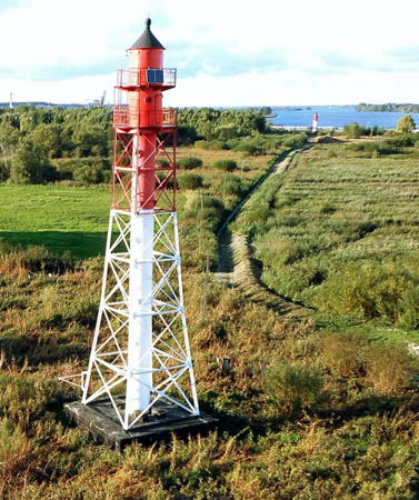
1926. Active; focal plane 25 m (82 ft); white light, 1 s on, 1 s off, visible only along the northwest-southeast channel crossing the sound. 24 m (79 ft) square pyramidal skeletal tower with lantern, watch room, double gallery, and enclosed central cylinder, mounted on a circular concrete base. Entire lighthouse painted red. Ruslan Nekrasov's photo is at right, Huelse has a photo, he also has a historic postcard view, another photo is available, Trabas also has a photo, and Google has a satellite view. Brama torowa means "channel gate" in Polish. Located on the east side of the channel a short distance south of the Chełminek South light. Accessible only by boat; there should be good view from Trzebież. Site and tower closed. Operator: Urząd Morski w Szczecinie. ARLHS POL-046; Admiralty C2722; NGA 6284.
Brama Torowa 4W {Papenwassertorfeuer West}
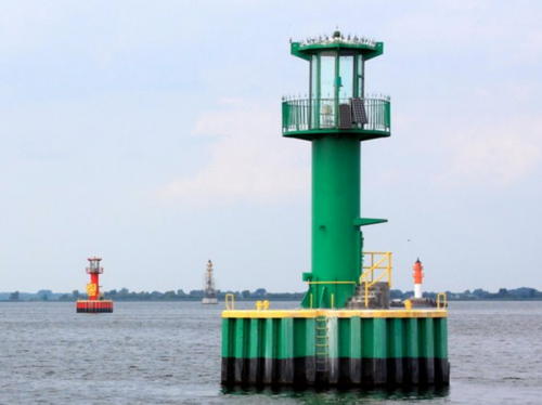
1926. Active; focal plane 25 m (82 ft); white light, 1 s on, 1 s off, visible only along the northwest-southeast channel crossing the sound. 24 m (79 ft) square pyramidal skeletal tower with lantern, watch room, double gallery, and enclosed central cylinder, mounted on a circular concrete base. Entire lighthouse painted green. A photo by Waldemar Olesniewicz is at the top of this page, Huelse has a good photo, Ruslan Nekrasov has a photo, Trabas also has a photo, Wikimedia has a photo, and Google has a satellite view. Located on the west side of the channel a short distance south of the Chełminek South light. Accessible only by boat; there should be good view from Trzebież. Site and tower closed. Operator: Urząd Morski w Szczecinie. ARLHS POL-047; Admiralty C2721; NGA 6288.
* Trzebież Entrance Range Front
Date unknown. Active; focal plane 11 m (36 ft); orange light occulting once every 4 s. 12 m (39 ft) square skeletal tower, painted white and carrying a diamond-shaped slatted daymark painted orange. Trabas has a photo, Mirosław Mazański has a nice view, and Google has a distant satellite view and a distant street view. Trzebież (formerly Ziegenort) is a small town in Police County on the west side of the mouth of the Odra. This range guides vessels approaching Trzebież from the south. Located on the town waterfront. Site open, tower closed. Operator: Urząd Morski w Szczecinie. Admiralty C2725.4; NGA 6324.
Trzebież Entrance Range Rear
Date unknown. Active; focal plane 18 m (59 ft); orange light occulting once every 4 s. 16 m (52 ft) square skeletal tower, painted white and carrying a triangular slatted daymark painted orange. Trabas has a photo and Google has a distant satellite view. Located 381 m (1/4 mi) west of the front light. Site open, tower closed. Operator: Urząd Morski w Szczecinie. Admiralty C2725.5; NGA 6328.

Brama Torowa 4E, Trzebież, August 2013
Google Maps photo by Ruslan Nekrasov
* Trzebież North Range Front
Date unknown. Active; focal plane 11 m (36 ft); white light, 3 s on, 1 s off. 10 m (33 ft) square skeletal tower, painted white and carrying a rectangular slatted daymark painted red. Trabas has a photo and Google has a satellite view. This range guides vessels approaching Trzebież from the north. Located on the waterfront of Trzebież. Site open, tower closed. Admiralty C2724; NGA 6300.
* Trzebież North Range Rear {Klein-Ziegenort Oberfeuer} (4?)
Date unknown (station established 1878). Active; focal plane 22 m (72 ft); white light, 3 s on, 1 s off. 20 m (66 ft) slender square skeletal tower, painted white and carrying a rectangular slatted daymark painted red. Trabas has a photo, Radek Radyjko has a drone view, and Google has a satellite view. Located on the south side of the village of Trzebież. Site open, tower closed. Admiralty C2724.1; NGA 6304.
* Stepnica Harbor Range Rear
Date unknown. Active; focal plane 19 m (62 ft); red light occulting once every 4 s. 17 m (56 ft) square skeletal tower, painted white and carrying a rectangular slatted daymark painted red with a white vertical stripe. Trabas has a photo by Capt. Peter Mosselberger and Google has a distant satellite view. The front light is on a mast. Stepnica (formerly Bad Stepenitz) is a village in Goleniów County on the east side of the lower Odra. Located about 200 m (220 yd) east of the harbor area. Site open, tower closed. Operator: Urząd Morski w Szczecinie. Admiralty C2726.1; NGA 6352.
Stepnica Range Rear {Stepenitz Oberfeuer} (2)
1928 (station established 1901). Active; focal plane 25 m (82 ft); white light occulting every 8 s. 24 m (79 ft) square pyramidal skeletal tower with lantern, watch room, double gallery, and enclosed central cylinder, mounted on a circular concrete base. Upper half of lighthouse painted orange, lower half white; lantern roof is black. This lighthouse is identical to the Brama Torowa towers. Huelse has a photo, Trabas has a second photo, Guenter Penk has a 2020 photo, another photo is available, and Google has a satellite view. The range guides northbound ships headed for the main part of the sound. According to Liedtke, this range replaced an earlier, land-based range that was in place at least by 1881. Located in the southeastern extension of the Zalew Szczeciński, about 4 km (2.5 mi) southwest of Stepnica. Accessible only by boat. Site and tower closed. Operator: Urząd Morski w Szczecinie. ARLHS POL-072; Admiralty C2730.1; NGA 6336.
Stepnica Range Front {Stepenitz Unterfeuer} (2)
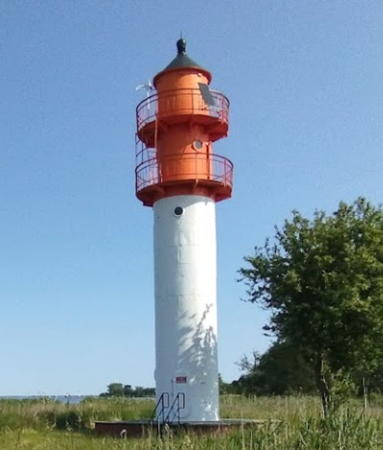
1928 (station established 1901). Active; focal plane 15 m (49 ft); white light occulting every 8 s. 15 m (49 ft) round cylindrical metal tower with lantern and double gallery, mounted on a circular concrete base. Lower half of lighthouse painted white, upper half orange; lantern roof is black. Huelse's photo is at right, Trabas has another photo, and Google has a satellite view. Located in the southeastern extension of the Zalew Szczeciński, 740 m (1/2 mi) south southeast of the rear light and about 5 km (3 mi) southwest of Stepnica. Accessible only by boat. Site and tower closed. Operator: Urząd Morski w Szczecinie. ARLHS POL-071; Admiralty C2730; NGA 6332.

Stepnica Range Front Light
photo copyright Klaus Huelse; used by permission
Odra Channel No. 20
Date unknown. Active; focal plane about 8 m (26 ft); continuous red light. 9 m (30 ft) round cylindrical tower with lantern and gallery mounted on a round caisson. Lighthouse painted red. This light is at the left in Andrzej Armiński's photo seen at right, Trabas has a photo ,and Bing has a satellite view. Located about 300 m (330 yd) south of the Stepnica Range Front Light. Accessible only by boat. Site and tower closed. Operator: Urząd Morski w Szczecinie. Admiralty C2728.2.
Odra Channel No. 21
Date unknown. Active; focal plane about 8 m (26 ft); continuous green light. 9 m (30 ft) round cylindrical tower with lantern and gallery mounted on a round caisson. Lighthouse painted green. Andrzej Armiński's photo is at right, he also has a closeup, Trabas has a photo, and Bing has a satellite view. Located about 400 m (440 yd) south of Light 21. Accessible only by boat. Site and tower closed. Operator: Urząd Morski w Szczecinie. Admiralty C2728.3.
Odra Channel No. 24
Date unknown. Active; focal plane about 8 m (26 ft); continuous red light. 9 m (30 ft) round cylindrical tower with lantern and gallery mounted on a round caisson. Lighthouse painted red. Trabas has a photo and Bing has a satellite view. Located about 400 m (440 yd) southeast of the Light 21. Accessible only by boat. Site and tower closed. Operator: Urząd Morski w Szczecinie. Admiralty C2728.4.
Żuławy {Königswerder}
1931. Active; focal plane 12 m (39 ft); white or red light, depending on direction, occulting every 4 s. 15 m (49 ft) square cylindrical skeletal tower with lantern and gallery, mounted on a circular concrete base. Upper half of lighthouse painted red, lower half white; lantern roof is black. Huelse has a photo, Trabas has a photo, and Google has a satellite view. This directional light guides vessels in both directions. Located about 2 km (1.2 mi) southeast of the Stepnica range lights. Accessible only by boat. Site and tower closed. Operator: Urząd Morski w Szczecinie. ARLHS POL-032; Admiralty C2732; NGA 6372.

Odra Channelt Light 21, August 2010
Light 20 at left, Stepnica Range Lights in the distance
Google Mpas photo by Andrzej Armiński

Odra River Entrance Lighthouses
Mańków (Mankow) Range Front {Gnageland Unterfeuer}
1928. Active; focal plane 15 m (49 ft); two white flashes every 8 s, visible only on or near the range line. 17 m (56 ft) round cylindrical metal tower with lantern and double gallery. Lower half of lighthouse painted white, upper half red; lantern roof is black. Huelse has a photo, Trabas has a closeup, Tomasz Przywecki has a view from the river, and Google has a satellite view. Located on the east bank of the Odra near the southeastern tip of the Zalew Szczeciński, where it guides southbound ships to the mouth of the Odra (Oder) River. Site status unknown. Operator: Urząd Morski w Szczecinie. ARLHS POL-030; Admiralty C2728; NGA 6292.
Mańków (Mankow) Range Rear {Gnageland Oberfeuer}
1928. Active; focal plane 32 m (105 ft); two white flashes every 8 s, visible only on or near the range line. 34 m (112 ft) square pyramidal skeletal tower with lantern, watch room, double gallery, and enclosed central cylinder. Upper half of lighthouse painted red, lower half white; lantern roof is black. Trabas has a photo showing both range lights and Bing has a satellite view. Located in a forest on the east bank of the Odra, 1.4 km (0.9 mi) southeast of the front light. Site status unknown. Operator: Urząd Morski w Szczecinie. ARLHS POL-031; Admiralty C2728.1; NGA 6296.
Krępa Range Rear {Krampe Oberfeuer}
1928 (daybeacon installed 1881). Active; focal plane 26 m (85 ft); white light occulting every 4 s. 25 m (82 ft) square pyramidal skeletal tower with lantern, watch room, double gallery, and enclosed central cylinder, mounted on a circular concrete base. Upper half of lighthouse painted orange, lower half white; lantern roof is black. This lighthouse is identical to the Brama Torowa towers. Huelse has a photo, Trabas has a closeup, Michał Szczepanik has a 2009 photo showing the tower surrounded by scaffolding, Ruslan Nekrasov has a photo, and Bing has a satellite view. The range guides northbound ships exiting the mouth of the Odra (Oder) River. Located about 1000 m (5/8 mi) north of the river's mouth. Accessible only by boat. Site and tower closed. Operator: Urząd Morski w Szczecinie. ARLHS POL-061; Admiralty C2736.1; NGA 6368.
Krępa Range Front {Krampe Unterfeuer}
1928 (daybeacon installed 1881). Active; focal plane 15 m (49 ft); white light occulting every 4 s. 15 m (49 ft) round cylindrical metal tower with lantern and double gallery, mounted on a circular concrete base. Lower third of lighthouse painted white, upper 2/3 red; lantern roof is black. Ruslan Nekrasov's 2013 photo is at right, Huelse has a photo, Trabas has a good photo, and Google has a satellite view. Sibling of the Stepnica Range Front lighthouse. Located just off the mouth of the Odra, 650 m (0.4 mi) south of the rear light. Accessible only by boat. Site and tower closed. Operator: Urząd Morski w Szczecinie. ARLHS POL-060; Admiralty C2736; NGA 6364.

Krępa Range Front Light,, August 2013
Google Maps photo by Ruslan Nekrasov

Police Area Lighthouses
Raduń Range Front {Schwabach Unterfeuer} (2)
1928 (station established 1901). Active; focal plane 15 m (49 ft); white light occulting twice every 8 s. 15 m (49 ft) round metal tower with lantern and double gallery. Upper half of lighthouse painted orange, lower half white. A 2023 photo by Tomek Krajewski is at right, Mariusz Deremacki has a 2020 photo, Huelse has a photo, Trabas has a closeup, Ruslan Nekrasov has a 2013 photo, and Google has a satellite view. This is the southbound entrance range for the Odra. Located on the east bank of the river about 2.5 km (1.5 mi) north of Police. Site status unknown. ARLHS POL-024; Admiralty C2734; NGA 6376.
Raduń Range Rear {Schwabach Oberfeuer} (2)
1928 (station established 1901). Active; focal plane 26 m (85 ft); white light occulting twice every 8 s. 28 m (92 ft) square pyramidal skeletal tower with lantern, watch room, double gallery, and enclosed central cylinder. Upper half of lighthouse painted orange, lower half white. This lighthouse is identical to the Brama Torowa towers. Huelse has a photo, Trabas has a good photo, Adam Nowacki has a 2022 photo, and Google has a satellite view. Located on the east bank of the river 800 m (1/2 mi) south southeast of the front light. Site status unknown. ARLHS POL-025; Admiralty C2734.1; NGA 6380.
Police Range Rear {Pölitz Oberfeuer} (3)
2000 (station established at least by 1902). Active; focal plane 60 m (197 ft); red light, 7.5 s on, 2.5 s off, synchronized with the front light. Approx. 54 m (175 ft) round hourglass-shaped concrete tower with two galleries but no lantern. Upper third of the lighthouse painted orange, middle third white, lower third black. Vyacheslav Lukasov has a 2020 closeup photo, Michał Szczepanik has a 2011 photo, Huelse has a photo, Trabas has a good photo, and Google has a good satellite view. These range lights are similar to the tall modern range lights common on the Elbe and Weser Rivers in western Germany. The range guides northbound ships departing Szczecin. Located about 250 m (0.15 mi) west of the river in an industrial area on the northeastern edge of Police, the county seat and a town of about 45,000 residents. Site and tower closed. ARLHS POL-070; Admiralty C2738.51; NGA 6389.1.
Police Range Front {Pölitz Unterfeuer} (3)
2000 (station established at least by 1902). Active; focal plane 37 m (121 ft); red light, 7.5 s on, 2.5 s off, synchronized with the rear light. Approx. 34 m (112 ft) round concrete tower with a flared (funnel-shaped) top and a gallery. There is a light atop the structure, but the range light is probably shown through a square window at the top of the tower. Upper half of the lighthouse painted orange, lower half white with a black band at the bottom. Huelse has a photo, Trabas has a photo by Efren Valiente, Kwiat Konwalia has a street view, and Google has a good satellite view. Located on a wharf on the west bank of the river in Police, adjacent to an industrial plant. Site and tower closed. ARLHS POL-069; Admiralty C2738.5; NGA 6389.

Raduń Range Front Light, Police, June 2023
Google Maps photo by Tomek Krajewski
Domańce {Schanzen, Damansch} (Cross Light)
1929. Active; focal plane 12 m (39 ft); white or red light depending on direction, occulting twice every 8 s; white light is shown over the upstream and downstream channels. 18 m (59 ft) square cylindrical skeletal tower with lantern and gallery. Tower painted white, lantern and gallery red. Trabas has a photo, Marek Kowalski has a street view, and Bing has a satellite view. The lighthouse resembles the Żuławy and Ińskie lights. The light helps guide ships around a change in the direction of the channel at Police. Located on the west bank of the river at Police. Site status unknown, but the light can be seen from a distance. ARLHS POL-023; Admiralty C2741; NGA 6384.
* Domańce (Politzer Wiesen) Range Front {Schanzen (Damansch) Unterfeuer} (2)
1927 (station established at least by 1902). Active; focal plane 15 m (49 ft); yellow light occulting every 4 s, synchronized with the rear light. 15 m (49 ft) round cylindrical metal tower with lantern and double gallery. Upper half of lighthouse painted red, lower half white; lantern roof is black. Huelse has a photo, Trabas has a fine closeup, Key Cee has a closeup, Janusz Typek has a photo, and Google has a satellite view. This range guides southbound ships toward Szczecin. Located on the west bank of the river at Czaoliniec, just east of Police. Site open, tower closed. ARLHS POL-052; Admiralty C2743; NGA 6392.
* Domańce (Politzer Wiesen) Range Rear {Schanzen (Damansch) Oberfeuer} (2)
1927 (station established at least by 1902). Active; focal plane 26 m (85 ft); white light occulting every 4 s, synchronized with the front light. 25 m (85 ft) square pyramidal skeletal tower with lantern, watch room, double gallery, and enclosed central cylinder. Upper half of lighthouse painted orange, lower half white. This lighthouse is identical to the Brama Torowa towers. Paweł Styczewski's drone view is at right (notice the front light in the distance), Tomasz Przywecki has a photo, Huelse has a photo, Trabas has a more distant photo, and Google has a satellite view. Located 660 m (0.4 mi) south of the front light. Site open, tower closed. ARLHS POL-053; Admiralty C2743.1; NGA 6396.

Święta Area Lighthouses
Łąki Range Rear {Flankengraben Oberfeuer}
1931. Active; focal plane 25 m (86 ft); white light occulting every 4 s. 23 m (79 ft) square pyramidal skeletal tower with lantern, watch room, double gallery, and enclosed central cylinder. Upper portion of lighthouse painted orange, lower portion white. This is a northbound range guiding ships toward Police. Huelse has a photo, Trabas has a photo, and Google has a satellite view. Łąki is the Polish word for "meadows." Located about 500 m (0.3 mi) north of the front light. Accessible by road. Site open, tower closed. ARLHS POL-063; Admiralty C2756.1.

Domańce Range Rear Light, Czaoliniec, September 2013
Google Maps drone view by Paweł Styczewski
* Łąki Range Front {Flankengraben Unterfeuer}
1931. Active; focal plane 15 m (49 ft); white light occulting every 4 s. 17 m (56 ft) round cylindrical metal tower with lantern and double gallery. Tower painted white, lantern and gallery red. Tom Light has a closeup photo, Huelse has a photo, Trabas has a closeup, and Google has a satellite view. Located on the east bank of the Odra about 2.5 km (1.5 mi) southwest of the Domańce Front Light. Site open, tower closed. ARLHS POL-062; Admiralty C2756.
Ińskie {Brachhorst}
1930. Active; focal plane 12 m (39 ft); white or red light depending on direction, occulting twice every 8 s; white light is shown over the upstream and downstream channels. 14 m (46 ft) square skeletal tower with lantern and gallery. Upper half of lighthouse painted red, lower half white. Adam Jacyno has a good 2008 photo, Huelse has a photo, another photo is available, Trabas also has a photo, and Google has a satellite view. The light helps guide ships around a change in the direction of the channel near Święta. Located on the east bank of the river about 1.5 km (0.9 mi) south of Święta. Site and tower closed. ARLHS POL-057; Admiralty C2754; NGA 6420.
Ina Range Southbound Front {Ihna Unterfeuer}
1911. Active; focal plane 16 m (52 ft); white light occulting every 8 s. 17 m (56 ft) square skeletal tower with lantern and gallery; the front of the tower is covered by metal panels as a daymark. Top of tower painted red, lower portion white. Huelse has a photo, Trabas has a closeup, and Google has a satellite view. The Ina Ranges guide ships around a curve in the river north of Czarna Lake. Located on the east bank of the river about 2.2 km (1.3 mi) south of Święta. Site status unknown. ARLHS POL-056; Admiralty C2746.9; NGA 6428.
Ina Range Common Rear {Ihna Oberfeuer}
1911. Active; focal plane 26 m (85 ft); white light, 5 s on, 3 s off. Approx. 24 m (79 ft) square skeletal tower with lantern and gallery; the two sides of the tower facing the range lines are covered by metal panels as a daymark. Upper half of tower painted red, lower half white. Łukasz Makowski has the 2016 photo seen at right, Huelse has a photo, Trabas has a distant view, and Google has a satellite view. Located east of the river about 625 m (0.4 mi) southeast of the southbound front light and 850 m (0.5 mi) north northeast of the northbound front light. Site status unknown. ARLHS POL-054; Admiralty C2747; NGA 6432.
Ina Range Northbound Front {Camelsberg}
1911. Active; focal plane 15 m (49 ft); white light occulting every 8 s. 17 m (56 ft) square skeletal tower with lantern and gallery; two sides of the tower are covered by white metal panels as a daymark. Top of tower painted red, lower portion white. Tomasz Przywecki has a photo, Trabas has a closeup photo, and Google has a satellite view. Located on the east bank of the river about 4 km (2.5 mi) south of Święta; there is a road leading to this area. Site status unknown. ARLHS POL-055; Admiralty C2747.1; NGA 6436.

Ina Common Rear Light, Święta, March 2016
Google Maps photo by Łukasz Makowski

City of Szczecin Lighthouses

Babina {Babbinstrom}
1931. Active; focal plane 12 m (39 ft); white or red light depending on direction, occulting every 4 s. 14 m (46 ft) square skeletal tower with lantern and gallery. Upper half of lighthouse painted red, lower half white; lantern roof is black. Huelse has a photo, Trabas has a closeup, and Google has a satellite view. This directional light is located on the west side of the island of Mewia (Groß-Camelwerder), at the northwestern corner of Czarna Łąka, a large lake through which the river flows north of Szczecin. Accessible only by boat. Site status unknown. ARLHS POL-045; Admiralty C2750; NGA 6444.
Bykowo Range Front {Ochsengrab Unterfeuer}
1932. Active; focal plane 15 m (49 ft); white light occulting every 4 s. 16 m (52 ft) round metal tower with lantern and double gallery. Upper half of lighthouse painted orange, lower half white; lantern roof is black. Trabas has a closeup photo, Huelse has a photo showing both range lights, and Google has a satellite view. This range guides vessels southbound to the entrance of a canal (originally the Königsfahrt) west of Czarna Łąka, leading to Szczecin. The range replaced a single directional light, established in 1912 and located between the present front and rear lights. Located on the east side of the canal; accessible only by boat. Site status unknown. ARLHS POL-048; Admiralty C2762; NGA 6448.
Bykowo Range Rear {Ochsengrab Oberfeuer}
1932. Active; focal plane 24 m (79 ft); white light occulting every 4 s. 25 m (82 ft) square pyramidal skeletal tower with lantern, watch room, double gallery, and enclosed central cylinder. Upper half of lighthouse painted orange, lower half white; lantern roof is black. This lighthouse is identical to the Brama Torowa towers. Trabas has a closeup photo, Huelse has a photo showing both range lights, and Google has a satellite view. Located on the east side of the canal about 600 m (0.4 mi) south of the front light; accessible only by boat. Site status unknown. ARLHS POL-049; Admiralty C2762.1; NGA 6452.
Święta Range Front (2)
1931 (station established 1907). Active; focal plane 15 m (49 ft); white light occulting every 4 s. 16 m (52 ft) round metal tower with lantern and double gallery. Upper half of lighthouse painted orange, lower half white; lantern roof is black. Trabas has Werner Seiler's photo of the two range lights and Google has a satellite view. This is the southbound range guiding ships down the canal (originally the Königsfahrt) west of Czarna Łąka, leading to Szczecin. The range replaced daybeacons installed in 1893 and replaced in 1901. Located on the west side of the canal; probably accessible only by boat. Site status unknown. ARLHS POL-073; Admiralty C2764; NGA 6456.
Święta Range Rear (2)
1931 (station established 1907). Active; focal plane 26 m (85 ft); white light occulting every 4 s. 27 m (89 ft) square pyramidal skeletal tower with lantern, watch room, double gallery, and enclosed central cylinder. Upper half of lighthouse painted orange, lower half white. A photo is at right, Trabas has Werner Seiler's photo of the two range lights, and Google has a satellite view. Located on the west side of the canal; probably accessible only by boat. Site status unknown. ARLHS POL-074; Admiralty C2764.1; NGA 6460.

Święta Range Rear Light, August 2008
ex-Panoramio Creative Commons photo by 7alaskan

Information available on lost lighthouses:

Notable faux lighthouses:

Adjoining pages: North: Świnoujście Area

Return to the Lighthouse Directory index | Ratings key

Posted April 18, 2005. Checked and revised June 17, 2024. Lighthouses: 37. Site copyright 2024 Russ Rowlett and the University of North Carolina at Chapel Hill.