Lighthouses of Poland: Świnoujście Area

The Republic of Poland (Polska in Polish) is located to the south of the Baltic Sea between Germany and Belarus. Poland has a long history but in the last decades of the 1700s it lost its independence, partitioned in several stages by its then-neighbors Prussia, Russia, and Austria. Following World War I the 1919 Treaty of Versailles restored Poland's independence but gave the country only a small section of coastline at Gdynia. At the end of World War II in 1945 Poland's borders were shifted westward, reducing the size of the country but granting it a substantial coastline removed from the defeated Germany.

Since 1945 the coast line of Poland has stretched from Świnoujście in the west to Gdańsk Bay in the east. Poland has at least 26 lighthouses on its Baltic coast and also many lighthouses on the inland waterway that extends from Świnoujście to Szczecin. This page lists the lighthouses of the Świnoujście area and the northern portion of the waterway leading to Szczecin. The southern portion of the waterway is covered by the Odra River page and the remaining Baltic lighthouses are listed on the Poland's Baltic Coast page.

Poland is divided into 16 provinces called voivodeships (województwa), and the voivodeships are subdivided into powiats (counties) and gminas (municipalities). All the lighthouses of this page are in the voivodeship of West Pomerania (Zachodniopomorskie). West Pomerania became part of Prussia in 1720 and thus part of the German Empire when it was formed in 1871. As a result nearly all the lighthouses in the region were built under German administration. The German names of these lighthouses are shown in curly brackets {}.

In Polish a lighthouse is a "sea lantern," latarnia morska, plural latarnie morskie. Wyspa is an island, płycizna is a shoal, zatoka is a bay, zalew is a lagoon, cieśnina is a strait, rzeka is a river, falochron is a breakwater, and molo is a pier. The Baltic Sea is called the Morze Bałtyckie in Polish.

Active Polish lighthouses are operated by the regional Maritime Office (Urząd Morski). Previously there were three of these offices, in Szczecin, Słupsk, and Gdynia. In 2020 the Słupsk office was closed and its duties transferred to the Gdynia office. All of the lights on this page are managed by the Szczecin Maritime Office (Urząd Morski w Szczecinie).

ARLHS numbers are from the ARLHS World List of Lights. Light List numbers are from volume C of the Admiralty List of Lights & Fog Signals. U.S. NGA List numbers are from Publication 116.

General Sources
Polnische Leuchttürme
Photos posted in 2005 by Klaus Huelse, including many photos of the inland lighthouses. Special thanks to Klaus for the use of some of these photos here.
Lista latarń morskich w Polsce
Index to lighthouse articles in the Polish-language edition of Wikipedia.
Baken Swinemünde
Photos and historical accounts in German by Gerd Liedtke.
Online List of Lights - Poland - Zatoka Pomorska
Photos by various photographers posted by Alexander Trabas. Many of the photos for this area are by Rainer Arndt.
Leuchttürme an der polnischen Küste
Photos by Bernd Claußen.
Leuchttürme von Anke und Jens - Polen
This site has photos and information on lights of the Świnoujście area. Captions and comments in English.
Min Blinkfüer
Photos and accounts in German of German and Polish lighthouses.
Lighthouses in Poland
Photos by various photographers available from Wikimedia.
World of Lighthouses - Poland
Photos by various photographers available from Lightphotos.net.
Poland
Historic postcard views posted by Michel Forand.
Leuchttürme der ehemaligen deutschen Ostgebiete
Postcard views of historical German lighthouses in Poland and other former German Baltic territories, posted by Klaus Huelse.
GPSNauticalCharts
Navigational chart for the Świnoujście area.
Navionics Charts
Navigational chart for the Świnoujście area.


Świnoujście Light, Świnoujście, April 2023
Wikimedia Creative Commons photo by Unukorno

Galeriowa Light, Świnoujście, March 2022
Google Maps photo by Jacek Adamczak
Świnoujście City Lighthouses

Świnoujście Harbor Lighthouses
Świnoujście (shvee-now-oo-eesh-chuh) is a port town of about 50,000 residents occupying both sides of the mouth of the Świna River. There is no bridge over the river but a tunnel opened in June 2023.

Świnoujście Approach West Side
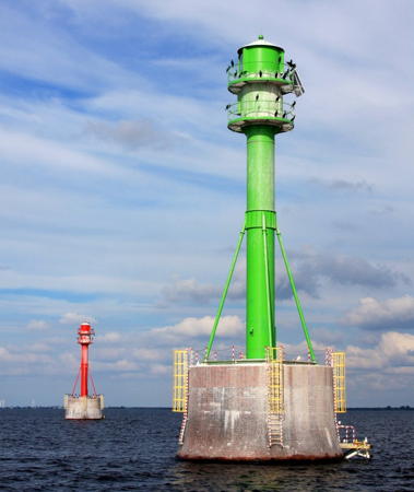
Date unknown. Active; focal plane 13 m (43 ft); green flash every 2 s. 13 m (43 ft) round cylindrical concrete tower painted green and mounted on a round concrete pier. Trabas has Arndt's photo but the light is not seen in Google's satellite view. Located in the Baltic Sea about 10 km (6 mi) north northwest of the Świna entrance. Accessible only by boat. Site open, tower closed. Admiralty C2667.5; NGA 6115.
Świnoujście Approach East Side
Date unknown. Active; focal plane 13 m (43 ft); red flash every 2 s. 13 m (43 ft) round cylindrical concrete tower painted red and mounted on a round concrete pier. Trabas has Arndt's photo but the light is not seen in Google's satellite view. Located in the Baltic Sea about 10 km (6 mi) north northwest of the Świna entrance. Accessible only by boat. Site open, tower closed. Admiralty C2667.8; NGA 6115.5.
* Młyny (Windmill) Range Front {Mühlenbake}
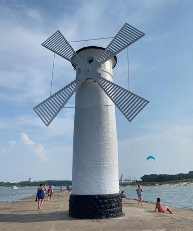
1902 (tower built 1877). Active; focal plane 11 m (36 ft); white light, 7.5 s on, 2.5 s off, synchronized with the rear light. 11 m (36 ft) round cylindrical brick tower, painted white. The front (seaward) side of the tower also sports four large white vanes as a "windmill" daymark, so that the tower looks from a distance as if it were a windmill. (The vanes do not turn in the wind.) Dawid Kowalski's 2020 street view is at right, Huelse has a good photo, Trabas has a closeup photo by Helmut Seger, Wikimedia has a photo by Oliwier Brzeziński, Karolina Bartosiak has a 2011 photo, Anke and Jens have photos, Forand has a 1929 postcard view, and Google has a satellite view. This is the front light of the entrance range for the Świna. The tower was built in 1877 as a daybeacon; it had only three vanes then, one pointed straight up. The present configuration dates from 1902, when the light was added. Located at the end of the short west mole at the mouth of the river; accessible by walking the mole. Site open, tower closed. Operator: Urząd Morski w Szczecinie. ARLHS POL-028; Admiralty C2670; NGA 6124.
* Galeriowa (Młyny Range Rear) {Galeriebake} (4)
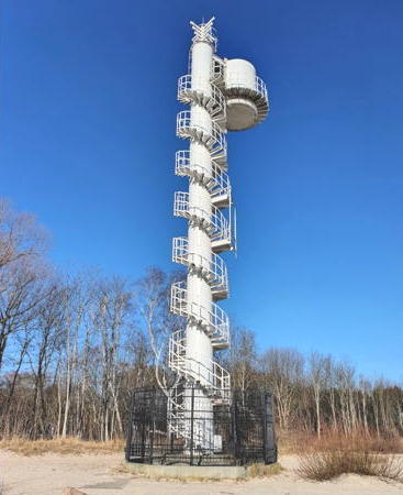
1931 (light station established 1902, daybeacon 1873). Active; focal plane 23 m (75 ft); white light, 7.5 s on, 2.5 s off, synchronized with the front light. 24 m (79 ft) concrete mast with a round lantern and gallery mounted to the front of the mast at the top. Access to the lantern is by an external stairway that spirals 7 times around the mast. Entire structure is white. Jacek Adamczak's 2022 photo of this unusual beacon is at the top of this page, Trabas has a good photo by Arndt, Anke and Jens have photos, Daniel Danek has a 2020 street view, and Google has a satellite view. Huelse has a postcard view of the original (1873) light. The modern light tower is located on the west bank of the Świna 520 m (1/3 mi) south southwest of the front light. Site open (there is parking near the lighthouse), tower closed. Operator: Urząd Morski w Szczecinie. ARLHS POL-027; Admiralty C2670.1; NGA 6128.

Młyny Light, Świnoujście, August 2020
Google Maps street view by Dawid Kowalski
Świnoujście East Mole {Swinemünde Ostmole} (5)
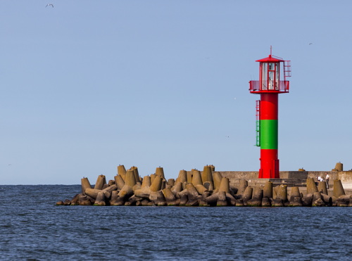
2000 (station established 1805). Active; focal plane 13 m (42 ft); red light occulting once every 4 s. 11 m (36 ft) round cylindrical tower with lantern and gallery painted red with one green horizontal band. Manfred Schmidt's photo is at right, a street view shows the green band. Trabas has a good photo by Arndt, the Anke/Jens lighthouse site has a 2005 photo showing the lighthouse painted all red, and Google has a satellite view. Huelse has a postcard view of the 1877 light, and Forand has a 1940 view of that light with a more modern lantern installed in 1925. According to Liedtke there were lights on the east mole as early as 1692, although the mole has been extended considerably since then. Located at the end of the east mole, which curves northwestward in front of the Świnoujście lighthouse. Accessible by walking the pier. Site open, tower closed. Operator: Urząd Morski w Szczecinie. ARLHS POL-026; Admiralty C2672; NGA 6120.
Świnoujście Entrance Breakwater
2015. Active; focal plane 13 m (43 ft); green light occulting once every 6 s. 11 m (43 ft) round cylindrical tower. Entire lighthouse is green. Trabas has Arndt's photo and Google has a satellite view and a distant street view. This light and the next one frame the entrance to a new LNG terminal on the east side of the river entrance. Located on a spur of the east mole. Site and tower closed. Admiralty C2672.3; NGA 6117.
Świnoujście East Breakwater
2015. Active; focal plane 13 m (43 ft); white or red light, depending on direction, occulting once every 6 s. 11 m (43 ft) round cylindrical tower. Entire lighthouse is red. A 2016 photo is available, Trabas has Werner Seiler's photo and Google has a satellite view and a very distant street view. This light and the previous one frame the entrance to a new LNG terminal on the east side of the river entrance. Located at the end of the 3 km (1.8 mi) long east breakwater built to shelter the terminal. Site and tower closed. Admiralty C2672.5; NGA 6117.5.

East Mole Light, Świnoujście, August 2016
photo copyright Manfred Schmidt; used by permission
**** Świnoujście {Swinemünde} (2)
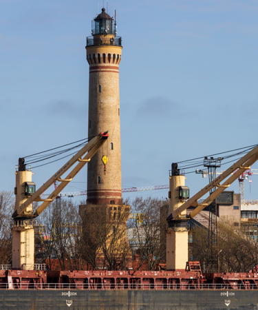
1857 (station established 1828). Active; focal plane 68 m (223 ft); white light 4 s on, 1 s off; red light is shown southwestward over the Świna for outbound ships. 65 m (213 ft) round brick tower with lantern and gallery rising from an octagonal base with a second gallery. Tower is unpainted yellow brick; lantern painted black. 1st order Fresnel lens in use. Adjacent 2-story brick keeper's house. A 2023 photo is at the top of this page, Trabas has a good photo by Arndt, Robert Jękot has a 2021 photo, Huelse has a photo, Anke and Jens have photos, Wikimedia has numerous photos, and Google has a satellite view and a street view of the base of the lighthouse. This magnificent lighthouse is the tallest brick lighthouse ever built; it is nearly 4 m (13 ft) taller than the Cape Hatteras Light in the U.S. The view from the gallery is about 45 km (28 mi) in clear weather. The tower was restored in 1902-03 to repair spalled brickwork; this project converted the tower's cross-section from the original octagonal to circular. Forand has a postcard view showing the lighthouse's original appearance and another view showing the result of the repairs. In 1945 retreating German troops ordered the destruction of the lighthouse but the German keeper could not bring himself to light the fuses and the tower survived. Damage from World War II was repaired belatedly in 1959. In 1998-2000, as a Millennium project, the lighthouse was completely restored and opened to the public along with a lighthouse museum in the keeper's house. Located on the east bank of the river Świna just inside the entrance. Site open, museum and tower open daily year round; there's very limited parking nearby but bus service from the city center is available. Operator: Urząd Morski w Szczecinie. Site manager: Latarnia Morska w Świnoujściu . ARLHS POL-019; Admiralty C2668; NGA 6116.
Kosa (Marine Pier) North End {Eichstaden Nord} (2)
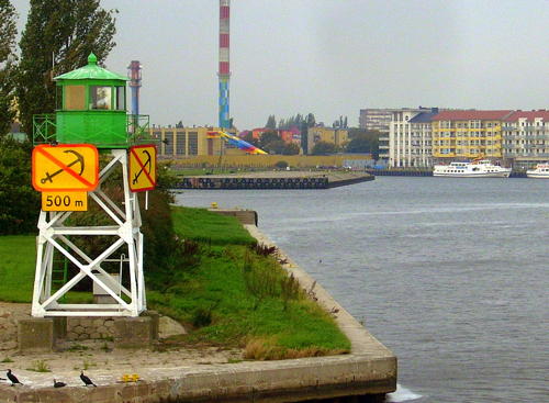
1913 (station established 1893). Active; focal plane 8 m (26 ft); green light occulting once every 4 s. 8 m (26 ft) square pyramidal skeletal tower with lantern and gallery. Tower painted white, lantern and gallery green. A photo is at right, Huelse has a photo, Claußen has a photo, the Anke/Jens lighthouse site also has a photo, Trabas has Arndt's closeup, and Google has a satellite view. A small war memorial is nearby. Located at the end of a long pier along the west side of the Świna channel about 2 km (1.2 mi) south southwest of the Galeriowa lighthouse. Site and tower closed (the area is restricted) but there's a close view from ferries crossing the harbor. Operator: Urząd Morski w Szczecinie. ARLHS POL-036; Admiralty C2678; NGA 6136.
Kosa (Marine Pier) South End {Eichstaden Süd} (2)
1913 (station established 1893). Active; focal plane 7 m (23 ft); green light occulting once every 4 s. 6.5 m (21 ft) square pyramidal skeletal tower with lantern and gallery. Lighthouse painted green. Trabas has a closeup photo, Michael Witkowski has a 2015 closeup, Sylwia Jabłońska has a 2023 photo, and Google has a satellite view. Located at the end of a long pier along the west side of the Świna channel about 2 km (1.2 mi) west southwest of the North End light. Site and tower closed (the area is restricted). Operator: Urząd Morski w Szczecinie. ARLHS POL-037; Admiralty C2678.75; NGA 6140.

Mielin Island Lighthouses
The island of Mielen (Wyspa Mielino) divides the Świna for about 3.5 km (2 mi). The navigation channel is on the west side of the island.

[Mielin North End {Großer Mellin Nord} (2)] (?)
Date unknown (2008?) (station established prior to 1902). Active ; focal plane 7 m (23 ft); quick-flashing red light. Approx. 4 m (13 ft) round red fiberglass tower. Trabas has Andreas Köhler's closeup photo, Renata Gremlik-Przemorska has a distant photo, and Google has a satellite view. NGA formerly listed the original light, a square pyramidal red skeletal tower with lantern and gallery. Located at the north end of the island of Mielen. Accessible only by boat. Site and tower closed. Operator: Urząd Morski w Szczecinie. ARLHS POL-064; Admiralty C2680; NGA 6156.

Kosa North End Light, Świnoujście, August 2014
ex-Google Plus photo by Jan M
Mielin North Range Rear
Date unknown. Active; focal plane 20 m (66 ft); green light occulting once every 4 s. 18 m (59 ft) square skeletal tower painted with red and white horizontal bands. Trabas has a photo and Google has a satellite view. This range guides northbound vessels past Mielin Island. Located 220 m (240 yd) north of the common front light. Site status unknown. Admiralty C2682.1; NGA 6168.
Mielin Ranges Common Front
Date unknown. Active; focal plane 15 m (49 ft); green light (for the north range) or white light (for the south range) occulting once every 4 s. 15 m (49 ft) square skeletal tower painted white. Trabas has a photo and Google has a satellite view. This is the front light for both the North and South Ranges. Located on the beach on the west side of the island. Site status unknown. Admiralty C2682; NGA 6164.
Mielin South Range Rear
Date unknown. Active; focal plane 20 m (66 ft); white light occulting once every 4 s. 18 m (59 ft) square skeletal tower painted with red and white horizontal bands. Trabas has a photo and Google has a satellite view. This range guides southbound vessels past Mielin Island. Located 220 m (240 yd) south southeast of the common front light. Site status unknown. Admiralty C2681.9; NGA 6172.
Mielin South End {Grüner Holm} (2)
1916 (station established prior to 1902). Active; focal plane 6 m (21 ft); red light, 2 s on, 2 s off. 7 m (26 ft) square pyramidal skeletal tower with lantern and gallery, painted red. Ruslan Nekrasov has a photo, Huelse has a photo, Claußen also has a photo, Trabas has a closeup, and Google has a satellite view. Located at the south end of the island of Mielen. Accessible only by boat. Site and tower closed. Operator: Urząd Morski w Szczecinie. ARLHS POL-065; Admiralty C2685; NGA 6176.

Kanał Piastowski Lighthouses
The Kanał Piastowski (Piast Canal) is a shortcut from Świnoujście to Szczecin Bay, 12 km (7.5 mi) long and 10 m (33 ft) deep. The German Empire built the canal between 1874 and 1880 and called it the Kaiserfahrt (Emperor's Way). Karsibór is the island the canal cuts off on its east side.

Kanał Piastowski North End (Karsibór North End) {Kleiner Mellin} (3)
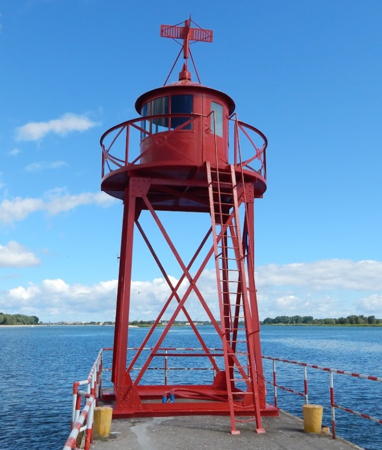
1958(?) (station established prior to 1901). Active; focal plane 7 m (23 ft); red or green light, depending on direction, occulting twice every 8 s. 8 m (26 ft) square pyramidal skeletal tower with lantern and gallery, painted red. A photo is at right, Huelse has a photo, Claußen also has a photo, Trabas has a closeup, Anke/Jens have a page with photos, Lightphotos.net has Andreas Köhler's 2022 closeup, and Google has a satellite view. Located at the north end of the Kanał Piastowski. Accessible only by boat. Site and tower closed. Operator: Urząd Morski w Szczecinie. ARLHS POL-068; Admiralty C2689; NGA 6188.

North End Light, Kanał Piastowski, June 2016
Google Maps photo by Amigo MD
* Karsibór Range Rear {Kaseburg Oberfeuer} (2)
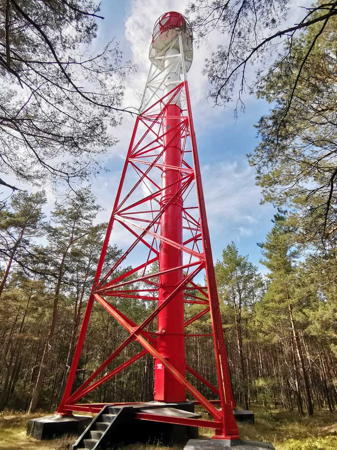
1931 (station established prior to 1893). Active; focal plane 39 m (128 ft); orange light, occulting once every 4 s, synchronized with the front light. 38 m (125 ft) triangular pyramidal skeletal tower with lantern, watch room, double gallery, and enclosed central cylinder. Lighthouse painted red with one white horizontal band. Trabas has Andreas Köhler's closeup photo seen at right, Huelse has a photo, and Bing has a satellite view. The Karsibór range lights are located west of the Kanał Piastowski; they guide vessels northbound through the waterway. Located about 800 m (1/2 mi) west of the north end of the Kanał Piastowski. Accessible by road. Site open, tower closed. Operator: Urząd Morski w Szczecinie. ARLHS POL-059; Admiralty C2690.1; NGA 6196.
* Karsibór Range Front {Kaseburg Unterfeuer} (2)
1931 (station established prior to 1893). Active; focal plane 15 m (49 ft); orange light, occulting once every 4 s, synchronized with the rear light. 15 m (49 ft) round cylindrical metal tower with lantern and gallery, painted white; lantern roof is red. Lightphotos.net has Andreas Köhler's 2022 closeup, Huelse has a photo, Trabas also has a photo, and Google has a satellite view. The lighthouse was rebuilt after storm damage in 1913. Located on the west bank of the Kanał Piastowski, 1.3 km (3/4 mi) southeast of the rear light. Accessible by road. Site open, tower closed. Operator: Urząd Morski w Szczecinie. ARLHS POL-058; Admiralty C2690; NGA 6192.
Karsibór West Side (No. 2)
Date unknown. Active; focal plane 9 m (30 ft); green light, 3 s on, 1 s off. 9 m (30 ft) round cylindrical white tower carrying a radar antenna. Trabas has Thomas Philipp's photo, a closeup photo is available, and Google has a satellite view. This is one of four synchronized green lights along the west bank of the Kanal; the other three are carried on skeletal masts. Located on the west bank of the Kanał Piastowski between the Karsibór Front and Paprotno Front Lights. Site status unknown. Admiralty C2686; NGA 6178.1.
Paprotno Range Front
Date unknown. Active; focal plane 13 m (43 ft); white light occulting once every 4 s. 14 m (46 ft) square skeletal tower painted white. Trabas has a photo and Google has a satellite view. This range guides southbound vessels. Located on the west side of the Świna opposite Karsibór. Site open, tower closed. Admiralty C2687; NGA 6180.
Paprotno Range Rear
Date unknown. Active; focal plane 20 m (66 ft); white light occulting once every 4 s. 18 m (59 ft) square skeletal tower painted with red and white horizontal bands and carrying a white triangular slatted daymark. Trabas has a photo and Google has a satellite view. Located 220 m (240 yd) south of the front light. Site open, tower closed. Admiralty C2687.1; NGA 6184.

Karsibór Range Rear Light, Karsibór Island, September 2022
photo copyright Andreas Köhler; used by permission

Zalew Szczeciński (Stettiner Haff) Lighthouses

Main Channel Lighthouses
The Szczecin Lagoon, known as Zalew Szczeciński in Polish or Stettiner Haff in German, is more than 40 km (25 mi) in length from east to west; the western end is in Germany. A dredged ship channel about 30 km (19 mi) long crosses the Polish basin of the lagoon diagonally from the Kanał Piastowski to the mouth of the Odra River. The channel (torowa) is marked by a series of pairs of lighthouses; each pair is called a gate (brama). For German lights at the west end of the lagoon see the Vorpommern-Greifswald page.
* Kanał Piastowski Entrance East (Brama Torowa 1E) {Kaiserfahrt Ost}
1931 (station established 1888). Active; focal plane 25 m (82 ft); white light, 1 s on, 1 s off, visible only along the line of the Kanał. 26 m (85 ft) square pyramidal skeletal tower with lantern, watch room, double gallery, and enclosed central cylinder, mounted on a 1-story square masonry base. Everything but the base painted red. Huelse has a photo, Trabas has a fine closeup, a 2021 photo is available, Adam Gierczycki has a view from the channel, and Google has a satellite view. This is the first of the Brama (Gate) Towers, a chain of lighthouses guiding ships across the Zalew Szczeciński (Stettiner Haff) to Szczecin. Towers 1E and 1W have been restored and repainted recently. Located adjacent to the base of the east mole at the entrance to the Kanał Piastowski from the Zalew Szczeciński. Site open, tower closed. Operator: Urząd Morski w Szczecinie. ARLHS POL-066; Admiralty C2693; NGA 6200.
* Kanał Piastowski Entrance West (Brama Torowa 1W) {Kaiserfahrt West}
1931 (station established 1888). Active; focal plane 25 m (82 ft); white light, 1 s on, 1 s off, visible only along the line of the Kanał; also a red general navigation light, occulting twice every 8 s, at a focal plane of 23 m (75 ft). 26 m (85 ft) square pyramidal skeletal tower with lantern, watch room, double gallery, and enclosed central cylinder, mounted on a 1-story square masonry base. Tower painted green, lantern and watch room red. Fog horn (Morse code "K," long-short-long, every 60 s). Paweł Wachholc's 2019 photo is at right, Andrzej Armiński has a 2010 photo, Trabas has a closeup photo, Huelse has a photo, and Google has a satellite view. Forand has a postcard view of the earlier light tower. Located adjacent to the base of the west mole at the entrance to the Kanał Piastowski from the Zalew Szczeciński. Site open, tower closed. Operator: Urząd Morski w Szczecinie. ARLHS POL-067; Admiralty C2694; NGA 6204.
* Kanał Piastowski East Breakwater
Date unknown. Active; focal plane 11 m (36 ft); red light occulting once every 4 s, synchronized with the east breakwater light. 9m (30 ft) round steel tower painted red. Trabas has a photo, Michał Firlej has a photo, and Google has a satellite view. Located on the east breakwater at the entrance to the Kanał Piastowski from the Zalew Szczeciński. Site open, tower closed. Admiralty C2695.6; NGA 6215.
* Kanał Piastowski West Breakwater
Date unknown. Active; focal plane 11 m (36 ft); green light occulting once every 4 s, synchronized with the east breakwater light. 9m (30 ft) round steel tower painted green. Trabas has a photo, Andrzej Armiński has a photo, and Google has a satellite view. Located on the west breakwater at the entrance to the Kanał Piastowski from the Zalew Szczeciński. Site open, tower closed. Admiralty C2695.5; NGA 6214.

Brama Torowa 1W, Kanał Piastowski, August 2019
Google Map photo by Paweł Wachholc
Zalew Szczeciński Northeast (Brama Torowa 2E) {Hafftorfeuer Nord Ost)
1931. Active; focal plane 25 m (82 ft); two white flashes every 8 s, visible only along the northwest-southeast channel crossing the sound. 21 m (69 ft) round cylindrical tower with lantern, watch room, double gallery, and tripod bracing mounted on a circular concrete base. Lighthouse painted red. Google has a satellite view. This is a renovation of the original tower 2E with its skeletal bracing removed and replaced by the tripod braces. Huelse has a good photo of the original appearance of the tower and Trabas has an excellent closeup. Located near the center of the Zalew Szczeciński, about 6.5 km (4 mi) northeast of the south shore near Podgrodzie. Accessible only by boat. Site and tower closed. Operator: Urząd Morski w Szczecinie. ARLHS POL-075; Admiralty C2700; NGA 6216.
Zalew Szczeciński Northwest (Brama Torowa 2W ) {Hafftorfeuer Nord West}
1931. Active; focal plane 25 m (82 ft); two white flashes every 8 s, visible only along the northwest-southeast channel crossing the sound; also a directional light, white, red or green flash every 4 s at a focal plane of 23 m (75 ft), shown over a sector to the west northwest. 21 m (69 ft) round cylindrical tower with lantern, watch room, double gallery, and tripod bracing mounted on a circular concrete base. Lighthouse painted green. This is a renovation of the original tower 2W with its skeletal bracing removed and replaced by the tripod braces. Google has a satellite view. Huelse has a good photo of the original appearance of the tower and Trabas has a closeup. Located near the center of the Zalew Szczeciński, about 6.5 km (4 mi) northeast of the south shore near Podgrodzie. Accessible only by boat. Site and tower closed. Operator: Urząd Morski w Szczecinie. ARLHS POL-076; Admiralty C2701; NGA 6220.
Zalew Szczeciński Southeast (Brama Torowa 3E ) {Hafftorfeuer Süd Ost}
1930. Active; focal plane 25 m (82 ft); three white flashes every 8 s, visible only along the northwest-southeast channel crossing the sound; also a directional light, white, red or green flash every 4 s at a focal plane of 22 m (72 ft), shown over a sector to the north. 21 m (69 ft) round cylindrical tower with lantern, watch room, double gallery, and tripod bracing mounted on a circular concrete base. Lighthouse painted red. Andrzej Armiński has a closeup photo and his distant view is at right, Trabas has Andreas Köhler's photo, and Google has a satellite view. This is a renovation of the original tower 3E with its skeletal bracing removed and replaced by the tripod braces. Huelse has a good photo showing the tower's original appearance. Located in the southeastern part of the Zalew Szczeciński, about 5 km (3 mi) north of the south shore west of Trzebież. Accessible only by boat. Site and tower closed. Operator: Urząd Morski w Szczecinie. ARLHS POL-077; Admiralty C2702; NGA 6224.
Zalew Szczeciński Southwest (Brama Torowa 3W) {Hafftorfeuer Süd West}
1930. Active; focal plane 25 m (82 ft); three white flashes every 8 s, visible only along the northwest-southeast channel crossing the sound. 21 m (69 ft) round cylindrical tower with lantern, watch room, double gallery, and tripod bracing mounted on a circular concrete base. Lighthouse painted green. Andrzej Armiński's photo is at right, Trabas has Andreas Köhler's photo, Ruslan Nekrasov has a photo, and Google has a satellite view. This is a renovation of the original tower 3W with its skeletal bracing removed and replaced by the tripod braces. Huelse has a good photo showing the tower's original appearance. Located in the southeastern part of the Zalew Szczeciński, about 5 km (3 mi) north of the south shore west of Trzebież. Accessible only by boat. Site and tower closed. Operator: Urząd Morski w Szczecinie. ARLHS POL-029; Admiralty C2703; NGA 6228.


Brama Tarowa 3W (right) and 3E, Zalew Szczeciński, August 2010
ex-Google Plus photo by Andrzej Armiński

Kamień County Lighthouses

For the Kikut lighthouse, also in Kamień County, see the Baltic Coast page

Eastern Zalew Szczeciński (Stettiner Haff) Lighthouses
Lubin Range Rear
Date unknown. Active; focal plane 53 m (174 ft); white light occulting twice every 8 s. Approx. 12 m (39 ft) square white skeletal tower carrying a diamnod-shaped slatted daymark. Trabas has a photo and Bing has a satellite view. The front light is on a short white skeletal mast. Lubin is a village on the east side of the Świna River where it flows out of the Zalew Szczeciński. Located on a hillside east of the village. Site open, tower closed. Admiralty C2706.1; NGA 6264.
* Zagórze {Sager} Range Front
Date unknown. Active; focal plane 15 m (49 ft); red light occulting once every 4 s. 12 m (39 ft) square white skeletal tower carrying a red diamond-shaped slatted daymark. Trabas has a photo, Lightphotos.net has Andreas Köhler's photo, and Google has a satellite view. Wolin is a town on the west side of the Dziwna River, which flows out of the east end of the Zalew Szczeciński. This is the second range guiding vessels on their approach to Wolin. Located on the east shore of the Dziwna River a short distant south of the village of Zagórze. Site open, tower closed. Admiralty C2715; NGA 6244.
* Zagórze {Sager} Range Rear
Date unknown. Active; focal plane 25 m (82 ft); red light occulting once every 4 s, synchronized with the front light. 14 m (46 ft) square white skeletal tower carrying a long red slatted daymark. Trabas has a photo, Lightphotos.net has Andreas Köhler's photo (also seen at right), and Google has a satellite view. Located in a farm field west of the village of Zagórze. Site open, tower closed. Admiralty C2715.1; NGA 6248.
Wolin (Skoszewo) Range Front
Date unknown. Active; focal plane 21 m (69 ft); white light, 2 s on, 2 s off. Approx. 20 m (66 ft) square white skeletal tower carrying a red diamond-shaped slatted daymark. Trabas has a photo and Google has a satellite view. This the first range guiding vessels on their approach to the east end of the bay and Wolin. Located on the east shore of the Zalew Szczeciński. Site status unknown. Admiralty C2714; NGA 6236.
Wolin (Skoszewo) Range Rear
Date unknown. Active; focal plane 34 m (112 ft); white light, 2 s on, 2 s off, synchronized with the front light. Approx. 14 m (46 ft) square red skeletal tower carrying a red diamond-shaped slatted daymark. Trabas has a photo and Google has a satellite view. Located on a hillside above the village of Skoszewo, 870 m (0.54 mi) east of the front light. Site status unknown. Admiralty C2714.1; NGA 6240.


Zagórze Range Rear Light, Zagórze, September 2022
photo copyright Andreas Köhler; used by permission

Information available on lost lighthouses:

Notable faux lighthouses:

Adjoining pages: East: Poland Baltic Coast | South: Odra River | West: Vorpommern

Return to the Lighthouse Directory index | Ratings key

Posted April 18, 2005. Checked and revised June 9, 2024. Lighthouses: 33. Site copyright 2024 Russ Rowlett and the University of North Carolina at Chapel Hill.