Lighthouses of Russia: Murmansk Area

Russia (Россия, Rossiya in Russian) is by far the world's largest country, spanning a little over 150° in longitude. It is organized as the Russian Federation (Rossiyskaya Federatsiya) with members known as federal subjects (sub'yekty federatsii). Russia is primarily a continental nation but it has important coastlines on the Baltic, Black, and Caspian Seas and very long coastlines on the Arctic Ocean and North Pacific Ocean. To guard these coasts it operates hundreds of lighthouses, many of them historic.

The northwestern corner of Russia lies on the Barents Sea, an arm of the Arctic Ocean. In Murmansk Oblast, one of the federal subjects, the broad, eastward-pointing Kola Peninsula (Kolskiy Poluostrov) separates the Barents Sea from the nearly-enclosed White Sea, which extends southward more than 500 km (300 mi). At the base of the peninsula, the fjord of Kola Bay (Kol'skiy Zaliv) cuts south from the ocean. The fjord is 57 km (35 mi) long and up to 7 km (4.3 mi) wide. Although it is quite deep, the fjord is known for its strong tidal currents and is not easy to navigate.

When Germany blocked the Baltic approaches to Russia during World War I the Tsarist government built a railroad to the far northwestern corner of the country and founded the port of Murmansk on Kola Bay. Under the Soviet government the Murmansk area became a major naval base and port of entry.

The Russian word for a lighthouse is mayak (маяк); ostrov is an island, poluostrov is a peninsula, kosa is a sandy spit, rif is a reef, mys is a cape, bukhta is a bay, zaliv is a larger bay or gulf, proliv is a strait, reka is a river, and gavan' is a harbor.

Russian lighthouses are owned by the Russian Navy and maintained by the Office of Navigation and Oceanography (Управление навигации и океанографии).

ARLHS numbers are from the ARLHS World List of Lights. Admiralty numbers are from volume L of the Admiralty List of Lights & Fog Signals. Russian light list (RU) numbers are from Russian Navy Publication 2103, as reported by the Admiralty. U.S. NGA numbers are from Publication 115.

General Sources
Online List of Lights - Russia - Arctic Sea Coast
Coming soon: photos by various photographers posted by Alexander Trabas.
Lighthouses in Murmansk Oblast
Photos by various photographers available from Wikimedia.
World of Lighthouses - Arctic Coast of Russia
Photos by various photographers available from Lightphotos.net.
Russische Leuchttürme auf historischen Postkarten
Historic postcard images posted by Klaus Huelse.
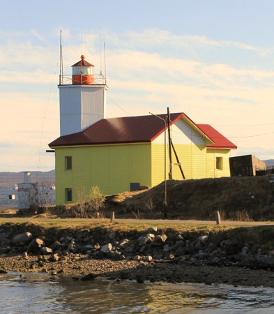
Mys Mishukov Light
Mys Mishukov Light, Murmansk, May 2012
ex-Panoramio photo copyright Konstantine Sushko; used by permission
Aleksandrovsk District (Kola Bay West Coast) Lighthouses
Formed in 2008, the Aleksandrovsk District is a merger of the closed towns of Gadzhiyevo, Polyarnyy, and Snezhnogorsk on the lower west side of Kola Bay. The area includes shipyards servicing the Russian nuclear submarine fleet.
Mys Set'navolok (Syet Point)
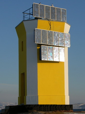
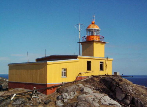
1900. Active; focal plane 73 m (240 ft); three quick red flashes followed by three quick green flashes every 10 s. 12 m (39 ft) square cylindrical tower with lantern and gallery, rising from the front of a 1-story keeper's house. The building is covered by metal siding painted bright yellow; the lantern is painted red. Fog horn (five blasts: short, three longs, and a short, every 60 s). A closeup photo is at right, Lightphotos.net has Dimas Samitay's closeup as well as the closeup seen at right, a distant view is available, and Google has a satellite view of the station. Lightphotos.net also has a historic photo and Wikimedia has a historic postcard view. This is clearly a staffed station. The metal siding probably covers deteriorated masonry. Igor Yakutik has a 2022 view from the sea that shows a red and white tower, presumably a lighthouse, on the point of the cape; the Admiralty does not list this light. The lighthouse stands at the west side of the entrance to Kola Bay. Site status unknown. ARLHS ERU-061; Admiralty L6218; RU-0275; NGA 14996.
Mys Lodeynyy (Lodeynoye)
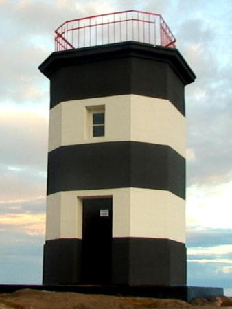
Date unknown (station established by 1950). Active; focal plane 49 m (161 ft); green flash every 4 s. 6 m (20 ft) octagonal cylindrical stone tower with gallery, painted with black and white horizontal bands. The EDM Company restored the light in 2005. Google has EDM's photo and an indistinct satellite view. Located on a promontory on the west side of Kola Bay about 5 km (3 mi) south of the Set'navolok lighthouse. Site status unknown. ARLHS ERU-104(?); Admiralty L6224; RU-0285; NGA 15000.
Ostrov Toros Range Rear
Date unknown. Active; focal plane unknown; continuous white light. Approx. 15 m (49 ft) square skeletal tower; the front of the tower carries a slatted daymark painted white with a red vertical stripe. Google has EDM's closeup photo and Bing has a satellite view. This northbound range guides vessels leaving Polyarnyy. Located at the south end of an island on the west side of Kola Bay south of Mys Lodeynyy. Accessible only by boat. Site status unknown. Admiralty L6227.51; RU-0306.
Setnavolok Light
Mys Set'navolok Light, Gadzhiyevo
Polar Post photo from lighthouse21v.narod.ru
Guba Kislaya Range Front
Date unknown. Active; focal plane 35 m (115 ft); red flash every 1.5 s. 9 m (30 ft) square pyramidal skeletal tower carrying a daymark colored white with a red vertical stripe. No photo available but Bing has a satellite view. The range guides vessels into sheltered bay on the west side of the fjord. Located on the south side of the entrance. Site status unknown. Admiralty L6227.3; NGA 15016.
Guba Kislaya Range Rear
Date unknown. Active; focal plane 76 m (249 ft); red flash every 2.5 s. 9 m (30 ft) square pyramidal skeletal tower carrying a daymark colored white with a red vertical stripe. No photo available but Bing has a satellite view. Located 0.9 km (0.56 mi) west of the front light. Site status unknown. Admiralty L6227.31; NGA 15020.
Ostrov Zelenyy (1)
Date unknown. Inactive. 6 m (20 ft) square concrete building; the light was formerly mounted on the roof. No photo available but Google has a satellite view of the station. Located on an island about 2 km (1.25 mi) southwest of Ostrov Toros. Accessible only by boat. Site status unknown.
Ostrov Zelenyy (2)
Date unknown. Active; focal plane 46 m (151 ft); flash every 3.5 s, white or red depending on direction. 8 m (26 ft) square pyramidal skeletal tower, covered with a slatted daymark painted yellow with a black vertical stripe. No photo available but Google has a satellite view of the station. This is an important leading light for ships entering Sayda Bay, a naval base on the west side of Kola Bay. Located adjacent to the older lighthouse. Accessible only by boat. Site status unknown. Admiralty L6229.5; RU-0333; NGA 15043.
Sayda Severnyy (Sayda North)
Date unknown. Active; focal plane 12 m (39 ft); white flash every 4 s. 5 m (17 ft) square pyramidal concrete tower, painted black with broad white vertical stripes. No photo available but Google has an indistinct satellite view. Located on the north side of the entrance to Sayda Bay. Site status unknown. Admiralty L6229.7; RU-0347; NGA 15028.


Mys Lodeynyy Light, Gadzhiyevo, 2005
photo copyright EDM Manufacturing Company, Severomorsk

Saydagubskiy Vkhodnoy (Sayda Bay Entrance) Range Front
Date unknown. Active; focal plane 16 m (52 ft); white flash every 3 s. 14 m (46 ft) square skeletal tower; the front of the tower carries a slatted daymark painted white with a red or black vertical stripe. Lightphotos.net has a photo by Sergey Shevkoplyas (this light is on the right) and Google has an indisinct satellite view. Located on the north side of the bay at a right-angle turn in the waterway. Site status unknown. Admiralty L6229.9; RU-0352.
Saydagubskiy Vkhodnoy (Sayda Bay Entrance) Range Rear
Date unknown. Active; focal plane 66 m (217 ft); white flash every 3 s. 16 m (52 ft) square skeletal tower; the front of the tower carries a slatted daymark painted white with a red or black vertical stripe. Lightphotos.net has a photo by Sergey Shevkoplyas (this light is on the left) and Google has an indistinct satellite view. Located on the north side of the bay at a right-angle turn in the waterway. Site status unknown. Admiralty L6229.91; RU-0353.
Saydagubskiy (Sayda Bay)
Date unknown. Active; focal plane about 12 m (39 ft); yellow flash every 5 s. 5 m (17 ft) cylindrical tower, painted with black and white horizontal bands. A view from the sea is at right and Google has a satellite view of the station. Located on a promontory on the south side of Sayda Bay about 1.6 km (1 mi) north of Gadzhiyevo. Site status unknown. Admiralty L6229.8; RU-0355.
Bol'shaya Voronukha
Date unknown. Active; focal plane 16 m (52 ft); flash every 4 s, white or red depending on direction. 10 m (33 ft) square cylindrical skeletal tower. The lighthouse is entirely covered by a round vertically slatted daymark, painted red with a white horizontal band. No photo available but Google has an indistinct satellite view. The EDM Company restored the light in 2004. Located on a small island on the west side of Kola Bay about 5 km (3 mi) north of Polyarnyy. Accessible only by boat. Site status unknown. ARLHS ERU-014; Admiralty L6229; RU-0309.5; NGA 15042.
Saydagubskiy Light
Saydagubskiy Light, September 2005
ex-Panoramio Creative Commons photo by fotoput
Ostrov Sedlovatyy (2)
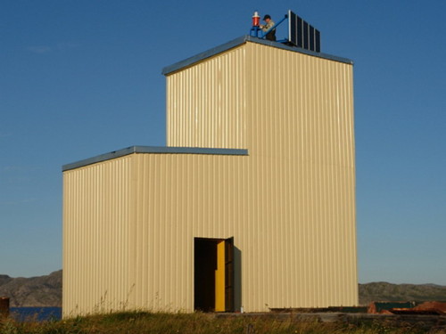
2006 (station established 1903). Active; focal plane 27 m (89 ft); green flash every 7 s. 12 m (39 ft) square cylindrical wood tower attached to a 1-story wood equipment shelter. The building is covered with pale yellow siding. The EDM Company restored this light station in 2006 and posted the closeup photo seen at right. Google has a satellite view of the station. The original lighthouse, with a lantern at one end of a small keeper's cottage, was about to collapse. In this case, restoration must have been a complete reconstruction. Located on an island on the west side of the channel through Kola Bay about 3 km (2 mi) north of Polyarnyy. Accessible only by boat. Site status unknown. ARLHS ERU-118; Admiralty L6248; RU-0312; NGA 15044.
Birin (Oleniya Bay Leading)
Date unknown. Active; focal plane 35 m (115 ft); continuous light, white or red depending on direction. 9 m (30 ft) square pyramidal skeletal tower; the front of the tower carries a slatted daymark painted red with a white vertical stripe. No photo available but Google has an indistinct satellite view. This is a leading light for vessels entering Oleniya Bay, a western branch of Kola Bay. Located on a bluff on the south side of the bay. Site status unknown. Admiralty L6249; RU-0412; NGA 15053.
Palagubskiy (Aleksandrovsk, Mys Glinoyetskiy) (2)
2012 (station established 1902). Active; focal plane 21 m (69 ft); flash every 5 s, white, red or green depending on direction. 8 m (26 ft) building with tower, painted yellow. Roman Teterin has a very distant view and Google has an indistinct satellite view. This is a new light at the location of a historic lighthouse, a 1-story wood keeper's house with a lantern at one end; Wikimedia has historic photos. The new light is built within the foundation of the old one. Located on a promontory at the west side of the entrance to Pala Bay and Polyarnyy (formerly called Aleksandrovsk). Site status unknown. Admiralty L6253; RU-0415; NGA 15056.
Ostrov Sedlovatyy Light
Ostrov Sedlovatyy Light, Polyarnyy, 2006
photo copyright EDM Manufacturing Company, Severomorsk
Aragubskiy (Palagubskiy) Range Rear
Date unknown. Active; focal plane 17 m (56 ft); red flash every 3.5 s. 8 m (26 ft) square cylindrical concrete tower with gallery. Lighthouse painted white; the entire front of the lighthouse carries a yellow daymark with a white vertical stripe. No photo available but Bing has a satellite view. This range guides vessels through a narrow passage into Ara Bay, the harbor of Polyarnyy, one of Russia's nuclear submarine ports. The EDM Company restored the light in 2007. Located at the south end of Ara Bay. Site and tower closed. Admiralty L6254.1; RU-0417; NGA 15068.
Ostrov Bol'shoy Oleniy (2)
2011. Active; focal plane 11 m (36 ft); one long white flash every 5 s. 5 m (17 ft) square tower, painted with yellow and black diagonal stripes. Lightphotos.net has a view from the fjord and Google has an indistinct satellite view. Wikimedia has photos of the original lighthouse, taken in 1974 and provided by Vyacheslav Lobanov. Located at the north end of the island of Bol'shoy Oleniy, marking the south side of the entrance to Oleniya Bay. Accessible only by boat. Site status unknown. Admiralty L6267; RU-0400; NGA 15052.
Ostrov Brandvakhta (2?)
Date unknown. Active; focal plane 16 m (52 ft); flash every 5 s, green or white depending on direction. 5 m (17 ft) square pyramidal concrete tower, painted white. The tip of the tower is seen in Roman Teterin's view from the sea and Google has a satellite view. Located on an island on the west side of Kola Bay about 2 km (1.2 mi) south of the Sayda Bay entrance. Accessible only by boat. Site status unknown. ARLHS ERU-085; Admiralty L6286; RU-0430; NGA 15108.
Ostrov Shurinov
Date unknown. Active; focal plane 12 m (39 ft); red light occulting once every 3 s. 6 m (20 ft) octagonal cylindrical brick tower, now covered with cement. Tower painted with yellow and white vertical stripes. The EDM Company restored the lighthouse in 2005 and posted the photo at right, and Google has a satellite view. Located on an island on the west side of Kola Bay off Goryachiye Ruch'i. Accessible only by boat. Site status unknown. Admiralty L6303; RU-0447; NGA 15128.
Mys Retinskiy
Date unknown. Active; focal plane 15 m (49 ft); white flash every 4 s. 5 m (17 ft) round concrete tower, painted with red and white diagonal bands. Evgeny Fisher has a view from the bay and Google has a satellite view. Located on a promontory of the west side of Kola Bay near Retinskoye. Site status unknown. ARLHS ERU-114; Admiralty L6314; RU-0507; NGA 15156.
Mys Retinskiy East Deviation Range Front (2 lights)
Date unknown. Active; focal plane 24 m (79 ft); continuous red light seen only in a narrow sector to the north. 12 m (39 ft) square pyramidal concrete tower, painted red with a white vertical stripe. Evgeny Fisher has a view from the bay, a 2021 street view shows all three lights on the cape, and Google has a satellite view. This is one of three similar towers shining lights along ranges from the cape. Located on a promontory of the west side of Kola Bay near Retinskoye. Site status unknown. Admiralty L6311.1; NGA 15162.
Mys Filinskiy Ranges Common Rear
Date unknown. Active; focal plane 25 m (82 ft); continuous white light. 20 m (66 ft) square skeletal tower. Probably at least two sides of the tower are covered with slatted daymarks. No photo available but Google has an indistinct satellite view. This lighthouse is the rear light for both northbound and southbound ranges in the Severomorsk area. Located on heights about 5 km (3 mi) southwest of Retinskoye. Site status unknown. ARLHS ERU-092(?); Admiralty L6319.4; NGA 15196.

Shurina Light
Ostrov Shurinov Light, Polyarnyy, 2005
photo copyright EDM Manufacturing Company, Severomorsk

Belokamenka (Mys Belokamennyy)
Date unknown. Active; focal plane 10 m (33 ft); white flash every 3 s. 8 m (26 ft) square skeletal tower. The upper half of the tower is surrounded by a round daymark colored red with a white horizontal band. A 2009 photo is seen at right and Google has a satellite view. The EDM Company restored the light in 2004. Located on a prominent cape near the village of Belokamenka. Site probably open, tower closed. ARLHS ERU-082(?); Admiralty L6332; RU-0607; NGA 15212.

Murmansk Lighthouses
Founded during World War I, Murmansk grew quickly to become the largest city north of the Arctic Circle. It retains this distinction although its current population of about 300,000 is a third less than its maximum size during the Cold War. Its name comes from a Sami name Murman for the Barents Sea coast.

Kiyevarakskiy Range Front
Date unknown. Active; focal plane 21 m (69 ft); continuous red light. 17 m (56 ft) square cylindrical skeletal tower. The tower is probably covered with a slatted daymark. Aleksey Burda has a distant view of the front and middle lights and the shadow of the light is seen in Google's satellite view. The range guides vessels leaving Murmansk on a long south-to-north reach passing Mishukovo. Located close to the highway along the fjord about 5 km (3 mi) northeast of Mishukovo. Site status unknown. Admiralty L6342; RU-0612; NGA 15224.
Kiyevarakskiy Range Middle
Date unknown. Active; focal plane 98 m (322 ft); continuous red light. 16 m (52 ft) square cylindrical skeletal tower. The tower is probably covered with a slatted daymark. Aleksey Burda has a distant view of the front and middle lights and the shadow of the light is seen in Google's satellite view. Located in a forest 220 m (725 ft) north of the front light. Site status unknown. Admiralty L6342.01; RU-0613; NGA 15226.

Belokamenka Light, Murmansk, August 2009
Google Maps photo by dihorik
Kiyevarakskiy Range Rear
Date unknown. Active; focal plane 21 m (69 ft); continuous red light. 17 m (56 ft) square cylindrical skeletal tower. The tower is probably covered with a slatted daymark. No photo available but the shadow of the light is seen in Google's satellite view. Located in a forest 500 m (0.3 mi) north of the front light. Site status unknown. Admiralty L6342.1; RU-0614; NGA 15228.
* Mys Mishukov (Misukovo)
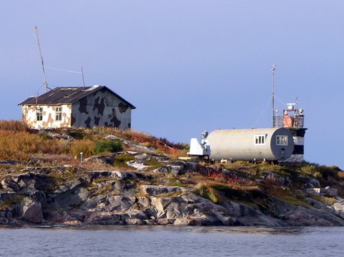
1937. Active; focal plane 20 m (66 ft); flash every 5 s, red or green depending on direction. 18 m (59 ft) octagonal cylindrical tower with lantern and gallery, rising from the elbow of a V-shaped 2-story building. The lighthouse is covered with siding, yellow on the building and white on the tower; lantern painted red and the roof is also red. Fog horn (four blasts every 34 s). Konstantine Sushko's photo is at the top of this page, Lightphotos.net has a closeup photo, Pavel Myshkovskiy has a 2021 photo, a 2016 closeup and another photo are available, and Google has a satellite view. Located on a sharp cape projecting into the west side of Kola Bay at Mishukovo, about 3 km (2 mi) north of Murmansk. This lighthouse is accessible by city streets in an urban area, but we do not know if visits to the area are restricted. Site apparently open, tower closed. ARLHS ERU-106; Admiralty L6346; RU-0625; NGA 15232.
[Anna Korga]
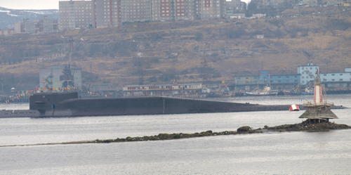
Date unknown. Active; focal plane 11 m (36 ft); red flash every 3 s. 10 m (33 ft) round concrete tower topped by a mast, mounted on a wood (?) pier. Konstantine Sushko's photo is at right and Google has an indistinct satellite view. Located on a shoal on the west side of the estuary north of the Murmansk waterfront. Accessible only by boat. Site open, tower closed. ARLHS ERU-011; Admiralty L6349; RU-0640; NGA 15238.

Russian Navy submarine passing Anna Korga Light, Murmansk, May 2010
photo copyright Konstantine Sushko; used by permission
Lagernyy Range Front
Date unknown. Active; focal plane 46 m (151 ft); continuous red light. 12 m (39 ft) octagonal concrete tower, painted yellow with a black vertical stripe facing the range line. No photo available but Google has a satellite view. This is a southbound range guiding vessels into Murmansk. Located on the west side of the estuary just north of Drovyanoy, south of the Murmansk waterfront. Site status unknown. Admiralty L6372; RU-0720; NGA 15264.
Lagernyy Range Rear (Drovyanoy)
Date unknown. Active; focal plane 91 m (299 ft); continuous red light. 12 m (39 ft) octagonal concrete tower, painted yellow with a black vertical stripe facing the range line. Google has a street view and satellite view. Located on the west side of the estuary, on the west side of the Kola Motorway (M18) and just north of Drovyanoy, south of the Murmansk waterfront. Site status unknown. Admiralty L6372.1; RU-0721; NGA 15268.

Severomorsk Area Lighthouses
Severomorsk is the headquarters of Russia's Northern Fleet and has the largest naval base in the Russian Arctic. The town is on the east side of Kola Bay about 25 km (15 mi) north of Murmansk. The town has a population approaching 55,000. It is one of the few towns in the Russian north that has gained population since 2000.

Mokhnatkin (Mohnatkin)
Date unknown. Active; focal plane 22 m (72 ft); green light, 1.5 s on, 3 s off. 4 m (13 ft) 1-story octagonal stone tower, painted red with a white horizontal band. EDM restored this lighthouse, and Google has EDM's photo seen at right and a satellite view. Located on a promontory on the east side of Kola Bay about 10 km (6 mi) northeast of Murmansk. (This lighthouse is in the Roslyakovo district, which was removed from Severomorsk and annexed to Murmansk in 2015.) Site status unknown. ARLHS ERU-107; Admiralty L6336; RU-0610; NGA 15216.
Okol'nyy Range Front
Date unknown. Active; focal plane 32 m (105 ft); continuous red light. 14 m (46 ft) square skeletal tower. The front of the tower is covered by a slatted daymark painted white with a red vertical stripe. No photo available but Google has a satellite view. This range guides northbound vessels on a long reach past Severomorsk. Located on a hillside facing west southwest, about 3 km (2 mi) northeast of the Severomorsk waterfront. Site status unknown. Admiralty L6316; RU-0517; NGA 15172.


Mokhnatkin Light, Murmansk, 2005
photo copyright EDM Manufacturing Company, Severomorsk

Okol'nyy Range Rear
Date unknown. Active; focal plane 67 m (220 ft); continuous red light. 12 m (39 ft) square skeletal tower. The front of the tower is covered by a slatted daymark painted white with a red vertical stripe. No photo available but Google has a satellite view. Located near what seems to be an abandoned military installation, about 1 km (0.6 mi) east northeast of the front light. Site status unknown. Admiralty L6316.1; RU-0518; NGA 15176.
Mys Sal'nyy (2)
Date unknown. Active; focal plane 14 m (46 ft); red flash every 6 s. 10 m (33 ft) square pyramidal concrete tower, listed with red and white horizontal bands. No photo vailable but Google has an indistinct satellite view. Located on a promontory of the east coast of Kola Bay southeast of Ostrov Sal'nyy. Site status unknown. Admiralty L6308; RU-0505; NGA 15152.
Ostrov Sal'nyy
Date unknown. Active; focal plane 36 m (118 ft); two flashes every 13.5 s, white, red or green depending on direction. 6 m (20 ft) vase-shaped octagonal metal tower mounted on a square platform. EDM restored this unusual light in 2007 and has the closeup photo seen at right, Lightphotos.net has a view by Sergey Shevkoplyas, Konstantin Abrosimov has a view from the sea and Google has a satellite view. Salnyy is a peanut-shaped island off the east coast of Kola Bay north of Severomorsk. Located on heights at the southwestern end of the island. Accessible only by boat. Site open, tower closed. ARLHS ERU-080(?); Admiralty L6306; RU-0500; NGA 15148.
Kol'skiy Mys Krestovyy (Mys Krestovskiy, Cape Cross) (2)
Date unknown. Active; focal plane 15 m (49 ft); white flash every 5 s. 10 m (33 ft) square cylindrical skeletal tower. The lighthouse is completely covered with a round, vertically slatted daymark and a conical topmark. The daymark is painted red and the topmark white. Lightphotos.net has a photo and Google has a satellite view. This lighthouse was restored by the EDM Company. Located on a promontory on the east side of Kola Bay about 10 km (6 mi) northeast of Severomorsk. Site status unknown. Admiralty L6304; RU-0495; NGA 15144.

Ostrov Sal'nyy Light
Ostrov Sal'nyy Light, Severomorsk, 2007
photo copyright EDM Manufacturing Company, Severomorsk


Tyuva Guba Area (Lower Kola Bay East Coast) Lighthouses
Mys Chirkovyy (Kol'skiy Vedushchiy, Kol'skiy Zaliv, Kola Bay) Range Front
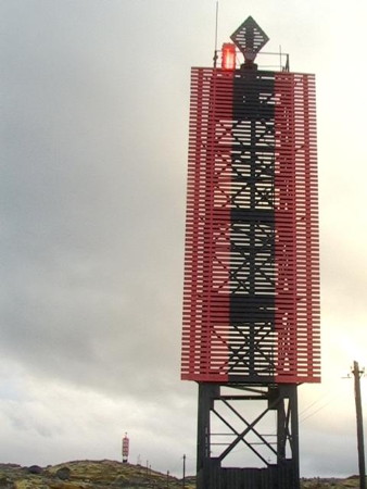
Date unknown. Active; focal plane 57 m (187 ft); continuous red light. 18 m (59 ft) square cylindrical skeletal tower. The front of the tower is covered by a slatted daymark painted red with a black vertical stripe, and at the top is a triangular slatted topmark, pointing up and painted black. No photo available but Google has an indistinct satellite view. These range lights guide arriving vessels through the first long reach southward in Kola Bay. Located on a hilly peninsula about 13 km (8 mi) northeast of Severomorsk. Site status unknown. Admiralty L6230; RU-0300; NGA 15132.
Mys Chirkovyy (Kolskiy Zaliv, Kola Bay) Range Middle
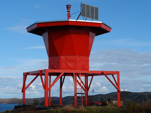
Date unknown. Active; focal plane 102 m (335 ft); continuous red light. 18 m (59 ft) square cylindrical skeletal tower. The front of the tower is covered by a slatted daymark painted red with a black vertical stripe, and at the top is a diamond-shaped slatted topmark, painted black. EDM restored these lights in 2005 and posted the closeup photo seen at right; Google has a satellite view. Located 420 m (1/4 mi) south of the front light. Site status unknown. Admiralty L6230.1; RU-0301; NGA 15136.
Mys Chirkovyy (Kolskiy Zaliv, Kola Bay) Range Rear
Date unknown. Active; focal plane 141 m (463 ft); continuous red light. 18 m (59 ft) square cylindrical skeletal tower. The front of the tower is covered by a slatted daymark painted red with a black vertical stripe, and at the top is a triangular slatted topmark, pointing down and painted black. The tower can be seen in the distance in EDM's photo of the middle light (seen at right), and Google has a satellite view. Located 500 m (0.31 mi) south of the middle light. Site status unknown. Admiralty L6230.2; RU-0302; NGA 15140.
Tyuva Guba (Tyuva Bay)
Date unknown (station established 1902). Inactive at least since 2009. 6 m (20 ft) square concrete tower, painted white with a red vertical stripe. 1-story wood keeper's house. Mark Romanov has a 2021 photo, Roman Teterin has a view from the bay, and Bing has a satellite view of the station. Located at the tip of the promontory on the south side of the entrance to Tyuva Bay. Site status unknown. ex-Admiralty L6294; ex-NGA 15088.
Tyuvagubskiy Osevay Range Front
Date unknown. Active; focal plane 42 m (138 ft); continuous red light. 14 m (46 ft) square skeletal tower. The front of the tower is covered by a slatted daymark painted white with a red vertical stripe. No photo available but Google has a satellite view. This range guides northbound vessels on a long reach south of Polyarnyy. The place name is misspelled Tyuragabskiy by NGA and ARLHS. Located atop a steep bluff on the south side of Tyuva Bay about 250 m (820 ft) east southeast of the Tyuva Guba lighthouse. Site status unknown. ARLHS ERU-127; Admiralty L6297; RU-0480; NGA 15092.
Tyuvagubskiy Osevay Range Rear
Date unknown. Active; focal plane 66 m (217 ft); continuous red light. 12 m (39 ft) square skeletal tower. The front of the tower is covered by a slatted daymark painted white with a red vertical stripe. A photo shows the light atop the hill at upper right and Google has an indistinct satellite view. The place name is misspelled Tyuragabskiy by NGA and ARLHS. Located atop a steep bluff on the north side of Tyuva Bay, 740 m (0.46 mi) northeast of the front light. Site status unknown. Admiralty L6297.1; RU-0481; NGA 15096.
Mys Chirkovyy Range Lights
Mys Chirkovyy Range Middle Light, Severomorsk, 2005
photo copyright EDM Manufacturing Company, Severomorsk
Mys Letinskiy (2)
Date unknown (station established by 1950). Active; focal plane 89 m (279 ft); white flash every 6 s. 18 m (59 ft) square skeletal tower. The tower is covered by a slatted daymark painted white with a red vertical stripe on each face. A distant view is available, Lightphotos.net has a view from the fjord and Bing has a satellite view. The original light was on a 6 m (20 ft) pyramidal tower. Located on a prominent cape on the east side of the entrance to Kola Bay from the Barents Sea. Site status unknown. ARLHS ERU-103; Admiralty L6226; RU-0455; NGA 15004.

Information available on lost lighthouses:

Notable faux lighthouses:

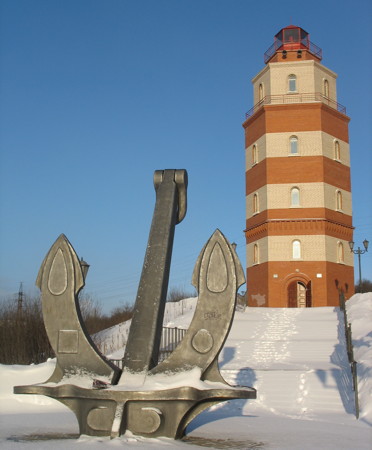
** Murmansk Sailors Memorial
Date unknown. Approx. 28 m (92 ft) hexagonal cylindrical tower with lantern and two galleries, painted with red and white horizntal bands. Evgeniy Lazarev's photo is at right, Anastasia Karkacheva has a fine photo, Lightphotos.net has a closeup photo, Austin Charron has also posted a good photo, Alexey Burda has a street view, and Google has a satellite view. This lighthouse is a memorial to seamen lost at sea in the Arctic. Located high on a hill above the city, it has no navigational value, but it deserves special mention as the only lighthouse in the Murmansk area readily accessible to tourists. A few feet from the lighthouse is an especially sobering memorial: the conning tower retrieved from the nuclear submarine Kursk, which sank with all 118 hands in the Barents Sea in August 2000. Site open, tower status unknown but probably open.
Tyuva Signal Station
Date unknown. This 2-story octagonal tower is located on a promontory on the north side of the entrance to Tyuva Gulf. Roman Teterin has a photo and Google has an indistinct satellite view. This historic building continues in use, but the tower does not carry a navigational light.

Adjoining pages: East: Northern Kola Peninsula | West: Pachenga Area

Return to the Lighthouse Directory index | Ratings key

Murmansk Memorial Light
Murmansk Memorial Light, Murmansk, February 2008
Wikimedia Creative Commons photo by Evgeniy Lazarev

Posted December 7, 2005. Checked and revised February 27, 2024. Lighthouses: 42. Site copyright 2024 Russ Rowlett and the University of North Carolina at Chapel Hill.