Lighthouses of Russia: Southern White Sea

Russia (Россия, Rossiya in Russian) is by far the world's largest country, spanning a little over 150° in longitude. It is organized as the Russian Federation (Rossiyskaya Federatsiya) with members known as federal subjects (sub'yekty federatsii). Russia is primarily a continental nation but it has important coastlines on the Baltic, Black, and Caspian Seas and very long coastlines on the Arctic Ocean and North Pacific Ocean. To guard these coasts it operates hundreds of lighthouses, many of them historic.

The northwestern corner of Russia lies on the Barents Sea, an arm of the Arctic Ocean. The broad, eastward-pointing Kola Peninsula (Kolskiy Poluostrov) separates the Barents Sea from the nearly-enclosed White Sea, which extends southward more than 500 km (300 mi). Arkhangel'sk, located at the southeasternmost point of the White Sea, became Russia's chief port under Ivan the Terrible in the mid 1500s and there has been a lively trade between Western Europe and Arkhangel'sk through these northern waters for almost 500 years.

This page lists includes lighthouses on the south side of the White Sea in the western part of the vast Arkhangel'sk Oblast, one of the members of the Russian Federation. This is the portion of the Oblast west of Arkhangel'sk City.

The Russian word for a lighthouse is mayak (маяк); ostrov is an island, mys is a cape, bukhta or guba is a bay, zaliv is a larger bay or gulf, proliv is a strait, reka is a river, and gavan' is a harbor.

Russian lighthouses are owned by the Russian Navy and maintained by the Navy's Office of Navigation and Oceanography (Управление навигации и океанографии).

ARLHS numbers are from the ARLHS World List of Lights. Russian light list (RU) numbers are from Russian Navy Publication 2105, as reported by the Admiralty. Admiralty numbers are from volume L of the Admiralty List of Lights & Fog Signals. U.S. NGA numbers are from Publication 115. The Russian light list, Огни и знаки (Lights and Signs), is not available online.

General Sources
Online List of Lights - Russia - Arctic Sea Coast
Coming soon: photos by various photographers posted by Alexander Trabas.
World of Lighthouses - Arctic Coast of Russia
Photos by various photographers available from Lightphotos.net.
White Sea Lighthouses in Russia
Photos by various photographers available from Wikimedia.com.
Russische Leuchttürme auf historischen Postkarten
Historic postcard images posted by Klaus Huelse.
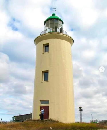
Zhizhginskiy Light, Primorsky, August 2023
Instagram photo by Irots

Onezhsky District Lighthouses

Onega Area Lighthouses
Founded in the 1780s, the historic town of Onega is located near the mouth of the Onega River. The river empties into the southeastern end of Onega Bay, the southernmost extension of the White Sea. With a population of about 20,000 the town is only a minor port.

Ostrov Baklan
Date unknown. Active; focal plane 13 m (43 ft); white flash every 7 s. 6 m (20 ft) square pyramidal wood skeletal tower, painted black. Wikimapia has two distant views and Bing has a satellite view. Located about 25 km (15 mi) west northwest of the mouth of the Onega River. Accessible only by boat. Site open, tower closed. RU-4795; Admiralty L6850; NGA 15892.
Mezhzavodskoy (Zavodskoy) Range Front
Date unknown. Active; focal plane 15 m (49 ft); green flash every 1.5 s. 12 m (39 ft) square cylindrical skeletal tower carrying a slatted daymark painted white with a red vertical stripe. No photo available but Google has a satellite view. Located on the south side of the Onega River opposite the city. Site open, tower closed. Admiralty L6876; NGA 15924.
Mezhzavodskoy (Zavodskoy) Range Rear
Date unknown. Active; focal plane 21 m (69 ft); green flash every 3 s. 16 m (52 ft) square cylindrical skeletal tower carrying a slatted daymark painted white with a red vertical stripe. No photo available but Google has a satellite view. Located beside a road on the south side of the Onega River 238 m (780 ft) southeast of the front light. Site open, tower closed. Admiralty L6876.1; NGA 15928.
Lesozavod (Lesopilyniy) Range Front
Date unknown. Active; focal plane 9 m (30 ft); continuous red light. 8 m (26 ft) square wood skeletal tower carrying a slatted daymark painted white with a red vertical stripe. No photo available but Google has an indistinct satellite view. Located on the south side of the Onega River 600 m (0.3 mi) east of the Mezhzavodskoy Rear Light. Site open, tower closed. Admiralty L6884; NGA 15940.
Lesozavod (Lesopilyniy) Range Rear
Date unknown. Active; focal plane 17.5 m (57 ft); continuous red light. 10 m (33 ft) square wood skeletal tower carrying a slatted daymark painted white with a red vertical stripe. No photo available but Google has a satellite view. Located beside a road on the south side of the Onega River 109 m (360 ft) southeast of the front light. Site open, tower closed. Admiralty L6884.1; NGA 15944.
Gorodskoy (Gorodskiy) Range Rear
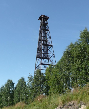
Date unknown. Active; focal plane 49 m (161 ft); continuous red light. 45 m (148 ft) square pyramidal skeletal tower with lantern and gallery, painted black. The tower carries a large slatted daymark painted white with a red vertical stripe. A photo is at right, Lighthphotos.net has Ilya Tarasov's photo, and Google has a satellite view. Located atop a riverside ridge on the north side of the Onega River 1370 m (0.85 mi) southeast of the front light. Site status unknown. RU-4846; Admiralty L6874.1; NGA 15920.
* Gorodskoy (Gorodskiy) Range Front
Date unknown. Active; focal plane 31 m (102 ft); continuous red light. 24 m (79 ft) square pyramidal skeletal tower, painted black. The tower carries a large slatted daymark painted white with a red vertical stripe. A photo (2/3 the way down the page) is available and Bing has a satellite view. Located near the waterfront in downtown Onega. Site probably open, tower closed. ARLHS ERU-241; RU-4845; Admiralty L6874; NGA 15916.
Pikhnemskiy No. 2 Range Rear
Date unknown. Active; focal plane 30 m (98 ft); continuous white light. 29 m (95 ft) skeletal tower carrying a large daymark painted white with a red vertical stripe. No photo available but Google has a satellite view. Located 1.1 km (0.7 mi) east southeast of the front light. Site status unknown. RU-4831; Admiralty L6870.1; NGA 15912.
Gorodskoy Range Rear Light
Gorodskoy Range Rear Light, Onega, August 2008
ex-Panoramio photo copyright IvSPb; used by permission
Pikhnemskiy No. 2 Range Front (2?)
Date unknown. Active; focal plane 24 m (79 ft); continuous green light. 24 m (79 ft) square cylindrical skeletal tower with lantern and gallery, carrying a large slatted daymark painted white with a red vertical stripe. A 2021 photo is seen at right and Google has a satellite view. Light lists describe a pyramidal tower. Located on the coast on the north side of the entrance to the Onega River. Site status unknown. RU-4830; Admiralty L6870; NGA 15908.
Pikhnemskiy No. 1 Range Front
Date unknown. Active; focal plane 18 m (59 ft); continuous white light. 17 m (56 ft) skeletal tower carrying a large slatted daymark painted white with a red vertical stripe. Lightphotos.net has a photo and a second photo by Jaroslav Kuznetsov and Google has a satellite view. This is the approach range for Onega. Located on the coast about 3 km (2 mi) northwest of the town. Accessible by road. Site status unknown. ARLHS ERU-265; RU-4805; Admiralty L6864; NGA 15900.
Pikhnemskiy No. 1 Range Rear
Date unknown. Active; focal plane 28 m (92 ft); continuous white light. 27 m (89 ft) skeletal tower carrying a large slatted daymark painted white with a red vertical stripe. No photo available but Google has a satellite view. Located in a forest 1.2 km (3/4 mi) east of the front light; the forest has been cleared along the range line. Site status unknown. RU-4806; Admiralty L6864.1; NGA 15904.
Ostrova Shogly
Date unknown. Active; focal plane 10 m (33 ft); flash every 3 s, white, red or green depending on direction. 5 m (17 ft) round lantern mounted on a concrete base. The lantern is listed as red, but it appeared yellow in a photo (no longer online). No photo currently available but Google has a satellite view. The Shogly Islands extend along a long shoal stretching northwest from the mouth of the Onega River. Located on the northernmost island, about 18 km (12 mi) from the river entrance. Accessible only by boat. Site open, tower closed. RU-4790; Admiralty L6860; NGA 15896.

Pikhnemskiy No. 2 Range Front Light, Onega, June 2021
Google Maps photo by The Team Game

Southern Onega Bay and Peninsula Lighthouses
The broad Onega Peninsula projects northwestward into the White Sea, separating Onega Bay on the southwest from Dvina Bay on the northeast. The peninsula is about 150 km (90 mi) long and about 65 km (40 mi) wide. Only the southern part of the peninsula is in the Onezhsky District.

Ostrov Pulonets
Date unknown. Active; focal plane 18 m (59 ft); white flash every 3 s. 12 m (39 ft) square pyramidal wood skeletal tower, supposedly painted black, but the structure lacks paint in the only available photo. The islet does not appear in Google's satellite view. Located on an isolated rock in the southeastern end of Onega Bay about 25 km (15 mi) southwest of Lyamitsa. Accessible only by boat. Site open, tower closed. ARLHS ERU-268; RU-4750; Admiralty L6844; NGA 15952.
Ostrov Purluda (Perkhluda)
Date unknown. Active; focal plane 29 m (95 ft); flash every 5 s, white or red depending on direction. 5 m (16 ft) round black lantern mounted on a concrete pad. A photo (halfway down the page) is available, the lantern is near the right edge of Victor Vasilievich Feofilatiev's view from the sea, and Bing has an indistinct satellite view. Located at the summit of a small island about 10 km (6 mi) south of a promontory of th Onega Peninsula. Accessible only by boat. Site open, tower closed. ARLHS ERU-166; Admiralty L6896; NGA 15948.
Lyamitsa (Lyamitskiy) (?)
Date unknown. Active(?); focal plane 37 m (121 ft); flash every 8 s, white or red depending on direction. 11 m (36 ft) square pyramidal wood skeletal tower. No photo available and no tower is seen in Google's satellite view of the location. Located near the village of Lyamitsa on the eastern shore of Onega Bay. Site status unknown. ARLHS ERU-254; RU-4725; Admiralty L6900; NGA 15956.

Western Primorsky District Lighthouses

Western Onega Peninsula Lighthouses
Mys Chesmenskiy
1901. Active; focal plane 38 m (125 ft); white or red light, depending on direction, 4.5 s on, 7.5 s off. 19 m (62 ft) octagonal cylindrical brick tower with lantern and gallery, rising from the front of a 2-story keeper's house. The lighthouse is covered with meta siding colored dark red with white trim. Fog horn (two blasts every 90 s). A 2020 photo is at right, Wikimapia has a photo, Lightphotos.net has Ilya Tarasov's photo, a 2010 closeup is available, Geocaching.su has a photo, Oleg Timofeev has a view from the sea, and Bing has a satellite view of the station. There are two closeup photos (about 2/3 of the way down the page) of the lighthouse before it was restored; in these photos we see that the surface of the tower had spalled badly. Located on a headland on the western shore of Onega Bay about 15 km (10 mi) south of Pushlakhta. Site status unknown. . ARLHS ERU-238; RU-4710; Admiralty L6908; NGA 15968.
Mys Letne Orlovskiy (Mys Letniy-Orlov)
Date unknown (station established 1911). Active; focal plane 12 m (39 ft); white or red flash, depending on direction, every 6 s. 12 m (39 ft) square pyramidal wood (?) tower with lantern and gallery. Lighthouse painted white with a black vertical stripe on each face, lantern painted red. Abandoned 1-story wood keeper's house. Lightphotos.net has Yuri Matseevskii's photo and Ilya Tarasov's photo, another photo is available (a little more than halfway down the page), and Bing has a satellite view of the station. Located on a spit at the point of land marking the eastern entrance to Onega Bay, about 20 km (13 mi) northwest of Pushlakhta. Site status unknown. ARLHS ERU-055; RU-4665; Admiralty L6914; NGA 15980.

Chesmenskiy Light, Cape Chesmen, August 2020
Instagram photo by Anna's lighthouses

Solovetskiy Islands Lighthouses
The Solovetskiy Islands are a group of six islands in the entrance to Onega Bay from the White Sea. The site of a historic monastery complex, the islands have a permanent population of about 850. The islands are accessible by air or (in the summer) by ferries from Arkhangelsk, Kem, and Belomorsk.

Pes'eludskiy (Ostrov Pes'ya Luda) Range Front
Date unknown. Active (?); focal plane 12 m (39 ft); white flash every 4 s. 7 m (23 ft) square pyramidal wood skeletal tower carrying a slatted daymark painted white with a red vertical stripe. A distant view shows both range lights and Google has a satellite view. Located on an islet off the entrance to Solovetskiy harbor. Accessible only by boat. Site open, tower closed. ARLHS ERU-264; RU-4490; Admiralty L6788.5; NGA 15820.
Pes'eludskiy (Ostrov Pes'ya Luda) Range Rear
Date unknown. Active (?); focal plane 12 m (39 ft); white flash every 4 s. 7 m (23 ft) square pyramidal wood skeletal tower carrying a slatted daymark painted white with a red vertical stripe. A distant view shows both range lights and Google has an indistinct satellite view. Located 205 m (1/8 mi) north of the front light. Accessible only by boat. Site open, tower closed. RU-4491; Admiralty L6788.51; NGA 15824.
** Ostrov Solovetsky (Solovki)
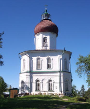
1863. Active; focal plane 98 m (322 ft); two white flashes every 8 s. 27 m (89 ft) Orthodox church with a lantern mounted atop its onion-shaped dome. 4th order (?) Fresnel lens in use. Church painted white, dome red, lantern green. Natalia Bochkareva's photo is at right, Manastirea Bujoreni has a photo, Huelse has a historic postcard photo, Evgeny Yezhkov has a street view, and Google has a satellite view. The Church of the Ascension is one of the many buildings associated with the Solovetsky Monastery, which was founded in the 1420s and is one of the most historic sites of the Russian North. The building was being repainted in the spring of 2009. Located atop Mount Sekirnaya, a hill on the northwestern corner of the island, about 8 km (5 m) northwest of Solovetskiy. Site open, building probably open, tower possibly open by arrangement. ARLHS ERU-064; RU-4470; Admiralty L6788; NGA 15812.
Ostrov Bol'shaya Muksalma (Malaya Muksalma)
Date unknown. Inactive; listed with focal plane 44 m (144 ft); white flash every 3 s. 12 m (39 ft) square pyramidal skeletal tower. The tower carries a slatted daymark painted black with a white horizontal band. Ruined 1-story wood keeper's cottage. No photo available but Google has an indistinct satellite view. Located at the eastern end of Ostrov Bol'shaya Muksalma, an island just off the southeastern coast of Ostrov Solovetskiy. Accessible only by boat. Site status unknown. ARLHS ERU-259; Admiralty L6790; NGA 15816.

Ostrov Solovetsky Light, Solovetsky, June 2019
Google Maps photo by Natalia Bochkareva
Anzerskiy
Date unknown. Inactive; listed with focal plane 61 m (200 ft); white flash every 4 s. 11 m (36 ft) square pyramidal skeletal tower with lantern. The tower carries a slatted daymark painted black with a white horizontal band. Ruined 1-story wood keeper's cottage. Lightphotos.net also has a closeup photo and Bing has a satellite view of the station. The lighthouse is abandoned. This lighthouse and the Orlovskiy lighthouse frame the eastern entrance to Onega Bay. Located at the eastern end of Ostrov Anzerskiy, about 15 km (9 mi) northwest of the Orlovskiy lighthouse. Accessible only by boat. Site status unknown. ARLHS ERU-158; RU-4456; Admiralty L6916; NGA 15984.

Northern Onega Peninsula Lighthouses
Zhizhginskiy Range Rear
1842. Active; focal plane 45 m (148 ft); two white flashes every 15.6 s. 20 m (66 ft) round brick tower, stucco covered, with lantern and gallery. Fog horn (two blasts every 20 s). Lighthouse painted a light cream color (described as yellow by NGA); the lantern dome is green. A 2023 photo is at the top of this page, a nice 2020 photo is available, and Google has a satellite view of the station. This lighthouse was restored, apparently in 2009. Before restoration much of the stucco was missing, leaving the tower a mottled red and cream; a good closeup photo and a second photo are available. The front light of the range is on a 7 m (23 ft) wood pyramid with a slatted daymark painted white with a red vertical stripe. Located on Ostrov Zhizhgin, an island 5 km (3mi) northwest of Kega, in the White Sea off the eastern entrance to Onega Bay. Site status unknown. . ARLHS ERU-074; RU-4580; Admiralty L6920; NGA 16000.
Churnavolok (Ostrov Churnavolokskiy) (1)
Date unknown. Inactive. 7 m (23 ft) gray stone pyramid. The light (focal plane 17 m (56 ft); white flash every 3 s) has been moved atop a 14 m (46 ft) skeletal mast next to the old tower. No photo available but Bing has an indistinct satellite view. Located on Ostrov Churnavolok, a small island at the end of a shoal extending off the northeastern point of Ostrov Zhizhgin. Site status unknown. ARLHS ERU-160. Active light: RU-4595; Admiralty L6932; NGA 16004.
Letnyy Navolok
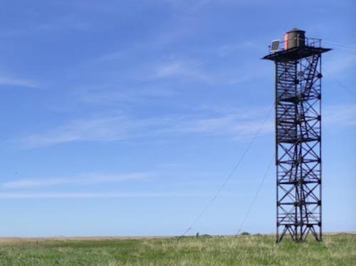
Date unknown. Active; focal plane 20 m (66 ft); white flash every 2 s. 15 m (49 ft) square cylindrical skeletal tower listed as carrying a black square daymark with white diagonal stripes. A photo is at right, a very distant view is available, and Bing has a satellite view. Located on the extreme northern tip of the Onega Peninsula. Site status unknown. ARLHS ERU-252; RU-4440; Admiralty L6934; NGA 16008.

Letnyy Navolok Light, Onega Peninsula
unattributed photo posted to Yandex.com

Dvina Bay Lighthouses
Lopshen'ga (Mys Plashkovskiy)
Date unknown. Active; focal plane 56 m (184 ft); white flash every 4 s. 12 m (39 ft) "pyramid," painted white with a black vertical stripe. No photo available but Bing has a satellite view. Located on a steep headland about 6 km (3.5 mi) north of the village of Lopshen'ga. Site status unknown. ARLHS ERU-253; RU-4415; Admiralty L6936; NGA 16012.
Mys Yaren'gskiy Rog (Unskiy) Range # 1 Front
Date unknown. Active; focal plane and light characteristic unknown. Square skeletal tower, height unknown. No photo available but Bing has a satellite view. Located about 800 m (1/2 mi) due east of the rear light (next entry). Site status unknown. Admiralty L6939.9.
Mys Yaren'gskiy Rog (Unskiy) (Common Range Rear)
Date unknown. Active; focal plane 31 m (102 ft); white flash every 1.5 s. 35 m (115 ft) skeletal tower carrying a black daymark with a white vertical stripe. No photo available but Bing has an indistinct satellite view of the station. This tower carries the rear lights of three ranges. However, the Admiralty listed it as "destroyed temporarily" in 2007, so it may have been replaced. More information is needed. Note: in the 1930s there was also a lighthouse at the nearby village of Unskiy Mayak; we don't know if anything survives of this lighthouse. Located on a prominent cape northwest of Pertominsk. Site status unknown. RU-4396; Admiralty L6940; NGA 16024.
Mys Yaren'gskiy Rog (Unskiy) Range # 2 Front
Date unknown. Active; focal plane and light characteristic unknown. Square skeletal tower, height unknown. No photo available but Bing has a satellite view. Located about 1200 m (3/4 mi) southeast of the rear light. Site status unknown. Admiralty L6940.1.
Mys Yaren'gskiy Rog (Unskiy) Range # 3 Front
Date unknown. Active; focal plane and light characteristic unknown. Square skeletal tower, height unknown. No photo available but Bing has a satellite view. Located about 1500 m (0.9 mi) south southeast of the rear light and 300 m (0.2 mi) southwest of Front Light #2. Site status unknown. Admiralty L6940.2.
Krasnaya Gora
Date unknown. Inactive but listed with focal plane 40 m (131 ft); white flash every 4 s. 23 m (75 ft) square wood skeletal tower carrying a slatted daymark painted red with a white vertical stripe. No photo available. Pavel Parfenov has a very distant view and Bing has a satellite view. The name of the light means "red cliff." Located at Krasnaya Gora, near the southeastern base of the Onega Peninsula. Site open and obviously nothing prevents climbing the tower. RU-4360; Admiralty L6939; NGA 16032.
* Syuz'ma
Date unknown. Inactive but listed with focal plane 49 m (160 ft); white flash every 2 s. 19 m (62 ft) square cylindrical skeletal tower. The tower carries a slatted daymark in the form of two trapezoids, the upper one painted black and the lower one white. Google has a distant satellite view. Located at the village of Syuz'ma. Site open, tower closed. ARLHS ERU-278; RU-4345; Admiralty L6944; NGA 16036.
Tolstik
Date unknown. Active; focal plane 49 m (160 ft); white flash every 4 s. 29 m (95 ft) square skeletal tower. The tower carries a slatted daymark in the form of two trapezoids, the upper one painted red and the lower one white. No photo available but Bing has a satellite view. This light is about 3 km (2 mi) east of Nyonoksa, the site of the State Central Navy Testing Range, where a serious accident involving a nuclear device occurred in August 2019. Site and tower closed. ARLHS ERU-280; RU-4340; Admiralty L6946; NGA 16040.

Severodvinsk Lighthouses
These lights are at the extreme southern end of Dvina Bay. Located at the western edge of the delta of the Northern (Severnaya) Dvina River, Severodvinsk is a major Russian naval base; many of the country's nuclear-powered submarines were built here and are based here. The city was called Molotovsk during the Soviet era.

Severodvinsk Range Front
Date unknown. Active; focal plane 19 m (62 ft); quick-flashing white light. 16 m (52 ft) square skeletal tower, painted black. The tower carries a slatted daymark painted white with a black vertical stripe. In a Google street view this light is the short tower right of center and the light casts a long shadow in Google's satellite view. Located on the waterfront in Severodvinsk. Site status unknown (probably closed). RU-4325; Admiralty L6948; NGA 16040.8.
Severodvinsk Range Middle
Date unknown. Active; focal plane 31 m (102 ft); two continuous green lights, one above the other, visible only on the range line. 27 m (89 ft) square skeletal tower, painted black. The tower carries a slatted daymark painted white with a black vertical stripe. In a Google street view this light is the tower left of center and the light casts a long shadow in Google's satellite view. Located 200 m (1/8 mi) southeast of the front light. Site status unknown (probably closed). RU-4325.1; Admiralty L6948.05; NGA 16040.81.
* Severodvinsk Range Rear
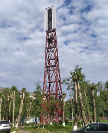
Date unknown. Active; focal plane unknown; two continuous red lights, one above the other, visible only on the range line. Approx. 40 m (131 ft) square skeletal tower, painted red. The tower carries a slatted daymark painted white with a black vertical stripe. Alexander Antonov has the 2020 closeup photo seen at right, Alexander Spiridonov posted a photo, and Google has a street view and a satellite view. Located south of the inner harbor in an area of Soviet-era apartment blocks. Site status unknown but the tower is easily seen from nearby streets. RU-4325.2; Admiralty L6948.1; NGA 16040.82.

Severodvinsk Range Rear Light, Severodvinsk, June 2020
Google Maps photo by Alexander Antonov

Information available on lost lighthouses:

Adjoining pages: East: Arkhangel'sk Area | Northwest: Northern White Sea

Return to the Lighthouse Directory index | Ratings key

Posted December 7, 2005. Checked and revised March 20, 2024. Lighthouses: 38. Site copyright 2024 Russ Rowlett and the University of North Carolina at Chapel Hill.