Lighthouses of Russia: Western Nenetsia

Russia (Россия, Rossiya in Russian) is by far the world's largest country, spanning a little over 150° in longitude. It is organized as the Russian Federation (Rossiyskaya Federatsiya) with members known as federal subjects (sub'yekty federatsii). Russia is primarily a continental nation but it has important coastlines on the Baltic, Black, and Caspian Seas and very long coastlines on the Arctic Ocean and North Pacific Ocean. To guard these coasts it operates hundreds of lighthouses, many of them historic.

Nenetsia, the Nenets Autonomous District, is recognized as one of the members of the Russian Federation although it is also described as an autonomous okrug (district) of the vast Arkhangel'sk Oblast. The population of Nenetsia is a little under 45,000, making it the least populous unit of the Federation. Nenetsia is located on the western Russian Arctic coast, at the southeastern corner of the Barents Sea and east of the entrance from that sea to the White Sea. At the eastern end of Nenetsia the Kara Strait connects the Barents Sea to the southwestern corner of the Kara Sea and separates Nenetsia from the island territory of Novaya Zemlya.

This page includes lighthouse of the western portion of Nenetsia, including the Barents Sea coast. The Eastern Nenetsia page covers the Vaygach Island area and the southwestern corner of the Kara Sea.

The Russian word for a lighthouse is mayak (маяк); ostrov is an island, mys is a cape, bukhta or guba is a bay, zaliv is a larger bay or gulf, proliv is a strait, reka is a river, and gavan' is a harbor.

Russian lighthouses are owned by the Russian Navy and maintained by the Navy's Office of Navigation and Oceanography (Управление навигации и океанографии).

ARLHS numbers are from the ARLHS World List of Lights. Russian light list (RU) numbers are from Russian Navy Publications 2103 (Barents Sea), 2105 (White Sea), or 2111 (Kara Sea) as reported by the Admiralty. Admiralty numbers are from volume L of the Admiralty List of Lights & Fog Signals. U.S. NGA numbers are from Publication 115.

General Sources
World of Lighthouses - Arctic Coast of Russia
Photos available from Lightphotos.net.
Online List of Lights - Russia - Arctic Sea Coast
Photos by various photographers posted by Alexander Trabas.
Europäische Leuchttürme auf historischen Postkarten
Historic postcard images posted by Klaus Huelse.
Kanin Nos Light, March 2018
Google Maps photo by Maxim Maxim
Kanin Peninsula Lighthouses
The anvil-shaped Kanin Peninsula projects northward into the Arctic Ocean, separating the northern White Sea on the west from the Barents Sea to the north and east. Shoyna is the only substantial settlement on the peninsula.

Reka Nes'
Date unknown. Active; focal plane 31 m (102 ft); white flash every 5 s. 21 m (69 ft) square skeletal tower carrying a slatted daymark painted with red and white horizontal bands. Lightphotos.net has Maxim Ldokov's very distant 2006 view but Google's satellite view has no detail in the area. Located on a headland on the north side of the entrance to the Nes' estuary, near the base of the west side of the peninsula. Site status unknown. RU 2105-3220; Admiralty L7100; NGA 16220.
Konushin Nos (Mys Konushin, Mys Konushinskiy)
Date unknown. Active; focal plane 62 m (203 ft); white flash every 5 s. 21 m (69 ft) tapered square skeletal tower, supposedly carrying a daymark painted yellow with a black vertical band. The daymark is not seen in a 2011 photo of the lighthouse posted on Lightphotos.net. Google has only a distant satellite view of the area. Located on a prominent cape about 120 km (75 mi) south of Shoyna. Site status unknown. RU 2105-3165; Admiralty L7105; NGA 16224.
Shoyna (2)
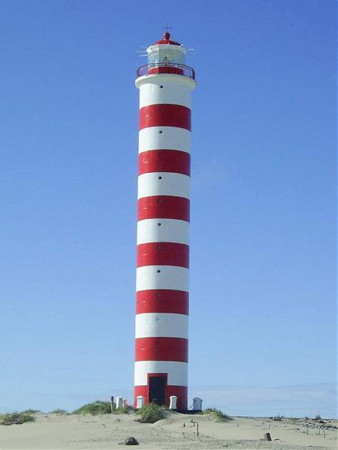
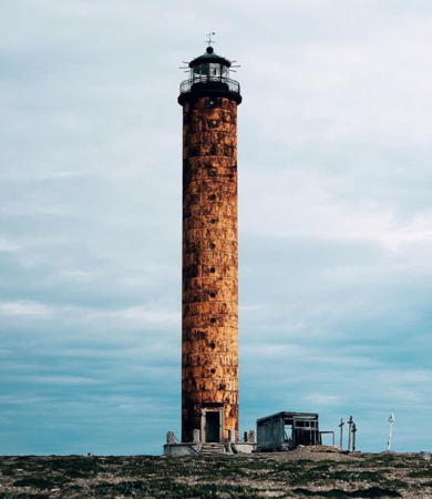
1960 (station established 1931). Active; focal plane 52 m (172 ft); two long white flashes every 10 s. 32 m (105 ft) cylindrical concrete tower with lantern and gallery, painted with horizontal red and white bands. A 2006 photo is at right, Lightphotos.net has a 2014 photo by Reega Regardos, and Google has a satellite view. The engineering company EDM restored the lighthouse in 2006; the photo at right must have been taken just after the restoration. This lighthouse has an important role in warning ships bound southeast into the White Sea away from the east coast. Located atop sand dunes on a promontory about 5 km (3 mi) northwest of the former fishing village of Shoyna. Site open, tower closed. ARLHS ERU-062; RU 2105-3130; Admiralty L7116; NGA 16240.
Kanin Nos
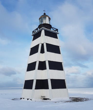
1915. Active; focal plane 75 m (246 ft); two white flashes every 13.8 s. 22 m (75 ft) cross-shaped pyramidal wood tower with lantern and gallery. Lighthouse painted with black and white horizontal bands; lantern painted black. Fog horn (Morse code "G": two longs and one short, every 30 s). A winter closeup is at the top of this page, Lightphotos.net has a 2012 closeup as well as a panoramic 2013 view of the station by Peter and Nataliya Bogorodskie, the Hydrographic Service posted a 2008 photo, a 2021 closeup is available, and Wikimedia has Mihail Gluhov's photo of the abandoned station buildings taken from the lighthouse, but Google has only a distant satellite view of the area. The lighthouse stands on the cape at the eastern entrance to the White Sea from the Barents Sea. Site status unknown. ARLHS ERU-037; RU 2103-1220; Admiralty L7140; NGA 16256.
Madakha
Date unknown. Probably inactive; listed with focal plane 49 m (161 ft); white flash every 5 s. 20 m (66 ft) skeletal tower, painted yellow, carrying a rectangular red daymark. No photo available and Google has only a very fuzzy satellite view of the area. Located on the central north coast of the peninsula. Site status unknown. ARLHS ERU-048; RU 2103-1225; ex-Admiralty L7146; NGA 16260.
Vostochnaya Kambal'nitsa (Ostrov Korga)
Date unknown. Active; focal plane 24 m (79 ft); white flash every 3 s. 19 m (62 ft) skeletal tower carrying a rectangular daymark painted white with a black vertical stripe. No photo available and Google has only a very distant satellite view of the island. Located on a sandy barrier island off the northeast coast of the peninsula. Site status unknown. RU 2103-1230; Admiralty L7152; NGA 16264.
Mys Mikulkin
Date unknown. Active; focal plane 25 m (82 ft); white flash every 3 s. 22 m (72 ft) skeletal tower carrying a round topmark painted brown. No photo available and Google has only a distant satellite view of the cape. Located at the eastern corner of the peninsula, marking the west side of the entrance to Chosha Bay. Site status unknown. RU 2103-1250; Admiralty L7158; NGA 16272.
Shoyna Light
Shoyna Light, Shoyna, 2006
Wikimapia photo, almost certainly by EDM

Chosha Bay Lighthouses
Chosha Bay occupies a circular basin on the southeast side of the Kanin Peninsula.

Nadteisalya
Date unknown. Inactive since 2010. 22 m (72 ft) skeletal tower carrying a round topmark painted white. No photo available and Google has only a distant satellite view of the area. Located on a promontory on the southeastern coast of the Kanin Peninsula. Site status unknown. ex-Admiralty L7158.5; ex-NGA 16277.
Oma
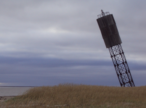
Date unknown. Inactive but listed with focal plane 25 m (82 ft); white flash every 3 s. 22 m (72 ft) square cylindrical skeletal tower; the top of the tower is surrounded by a round wooden daymark. Entire lighthouse painted black. Endangered: the 2015 photo at right shows the light tower leaning at a 25° angle. Google has only a fuzzy satellite view of the location. Located on the west side of the entrance to the Oma estuary, on the south shore of Chosha Bay. Site open, tower closed. RU 2103-1275; Admiralty L7160; NGA 16280.
Mys Bol'shoy Vzglavnyy (Reka Pesha)
Date unknown. Active; focal plane 34 m (112 ft); white flash every 5 s. 17 m (56 ft) square skeletal tower carrying a round daymark painted white with a black band. No photo available but Google has a satellite view. Located on the west side of the entrance to the Pesha River, at the southeastern corner of Chosha Bay. Site status unknown. RU 2103-1279; Admiralty L7165; NGA 16285.
Mys Suvoynyy
Date unknown. Active; focal plane 26 m (85 ft); white flash every 4 s. 24 m (79 ft) square skeletal tower carrying a rectangular daymark painted white with a black band. No photo available and Google has a only a distant satellite view of the cape. Located on a sharp cape on the east side of Chosha Bay about 80 km (50 mi) north of the Pesha River. Site status unknown. RU 2103-1315; Admiralty L7170; NGA 16290.
Mys Barmin
Date unknown. Active; focal plane 25 m (82 ft); white flash every 3 s. 15 m (49 ft) square skeletal tower carrying two circular black and white daymarks. No photo available and Google has a only a distant satellite view of the cape. Located on a sharp cape at the eastern entrance to Chosha Bay. Site status unknown. RU 2103-1320; Admiralty L7180; NGA 16296.

Oma Light, Chosha Bay, August 2015
ex-Panoramio photo copyright seliverstov; permission requested
Ostrov Timonets
Date unknown. Active; focal plane 12.5 m (40 ft); white flash every 7.5 s. 7 m (23 ft) square pyramidal wood skeletal tower covered with a slatted daymark, painted white with a black top. No photo available and the island is only a blur in Google's satellite view. Located on a small island about 8 km (5 mi) off the entrance to the Indiga River estuary. Accessible only by boat. Site status unknown. Admiralty L7184; NGA 16300.

Kolguyev Island Lighthouses
Ostrov Kolguyev is a roughly circular island about 80 km (50 mi) in diameter and 120 km (75 mi) northeast of the Kanin Peninsula. The island has a small Nenets settlement as well as bases for oil and gas production.

Kolguyev Vostochnyy (East Kolguyev)
Date unknown. Clearly inactive but listed with focal plane 35 m (115 ft); white flash every 5 s. 34 m (112 ft) square pyramidal skeletal tower. The tower also carries red square and rectangular white slatted daymarks. L. Stankevitch has the photo at right and Google has a satellite view. Located on the easternmost point of Kolguyev. Accessible only by boat. RU 2103-1430; Admiralty L7214; NGA 16312.
Ploskiye Koshki
Date unknown. Inactive but listed by NGA with focal plane 34 m (112 ft); white flash every 3 s. 33 m (108 ft) skeletal tower, painted with red and white horizontal bands. The tower also carries two square slatted daymarks. No photo available and Google has only a distant satellite view of the location. Located on a small island off the southeastern coast of Kolguyev. Accessible only by boat. RU 2103-1395; ex-Admiralty L7196; NGA 16308.

Kolguyev Vostochnyy Light, Ostrov Kolguyev, May 2013
Google Maps photo by L. Stankevitch
Kolguyev-Yuzhnyy (South Kolguyev)
Date unknown. Active; focal plane 22 m (72 ft); white flash every 5 s. 18 m (56 ft) skeletal tower carrying a rectangular daymark painted red with a white vertical stripe. No photo available and Google's distant satellite view has no detail. Located on the southernmost point of Kolguyev. Accessible only by boat. RU 2103-1382; Admiralty L7195; NGA 16309.
Kolguyev Severnyy (North Kolguyev)
Date unknown. Active; focal plane 73 m (240 ft); three white flashes every 15.4 s. 28 m (92 ft) tower. Lighthouse painted black with a white vertical stripe. No photo available and Google's distant satellite view has no detail. Located on the northernmost point of Kolguyev. Accessible only by boat. ARLHS ERU-044; RU 2103-1435; Admiralty L7210; NGA 16316.

Pechora Sea and Pechora Gulf Lighthouses
The southeastern corner of the Barents Sea, between Kolguyev and Vaygach islands, is known in Russia as the Pechora Sea (Pechorskoye More). The Pechora Gulf is an embayment of this sea that receives the outflow of the Pechora River. Naryan-Mar, the capital of Nenetsia, is located on the Pechora River 110 km (70 mi) from the mouth.

Cheshkiy (Svyatoy Nos, Cheshskaya)
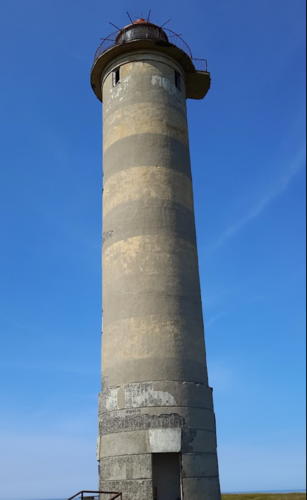
Date unknown. Active; focal plane 36 m (118 ft); one long (1.5 s) white flash every 6 s. 27 m (89 ft) cylindrical concrete tower with lantern and gallery, painted with black and yellow horizontal bands. A Fresnel lens is in use. Valeriy Kochev has the 2017 closeup seen at right and a view of the station, Igor Kuznetsov has a 2007 photo, Lightphotos.net also has a photo by Peter and Nataliya Bogorodskie, a view from the sea is available, and Google has a satellite view. The lighthouse marks the end of a long, narrow peninsula projecting into the sea at the eastern entrance to Cheshkiy Bay roughly 175 km (110 mi) east of Kanin Nos. (The cape is called Svyatoy Nos, but there is a better-known cape by that name at the western entrance to the White Sea.) Site status unknown. ARLHS ERU-022; RU 2103-1370; Admiralty L7190; NGA 16304.
Ostrov Sengeyskiy (2?)
Date unknown. Active; focal plane 35 m (115 ft); white flash every 6 s. 16 m (52 ft) square pyramidal skeletal (?) tower, painted black. A photo appears to show the original tower on the right and a newer tower on the left. Lightphotos.net has the same photo. Google's indistinct satellite view does not show the tower clearly. Located on Sengey island, a barrier island off the mainland opposite Kolguyev island. Site status unknown. RU 2103-1440; Admiralty L7220; NGA 16328

Cheshkiy Light, July 2017
Google Maps photo by Valeriy Kochev
Khodovarikha
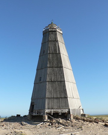
Date unknown. Active; focal plane 36 m (118 ft); two white flashes every 30 s. 26 m (85 ft) hexagonal wood-shingled tower with lantern and gallery, painted with black and white vertical stripes. That's the description, but Lightphotos.net has Konstantin Mikhailov's photo showing the lighthouse all black. Another photo is at right, Vladimir Raffe has a remarkable winter 2019 photo, Artur Muc has a 2019 photo, and Lightphotos.net has Konstantin Mikhailov's foggy view of the station, but Google has only a flurry satellite view of the area. Located on a headland of the mainland about 200 km (125 mi) east of Kolguyev Island. Site status unknown. ARLHS ERU-040; RU 2103-1465; Admiralty L7234; NGA 16344.
Mys Russkiy Zavorot
Date unknown. Active; focal plane 15 m (49 ft); 14 m (46 ft) square pyramid, painted with black and white horizontal bands. No photo available and Google has only a fuzzy satellite view of the area. Located near the end of the point on the west side of the entrance to the Pechora Gulf. Site status unknown. RU 2103-1475; Admiralty L7238; NGA16348
Gulyayevskiye Koshki No. 3
Date unknown. Active; focal plane 22 m (72 ft); white light, 2.2 s on, 4.8 s off. 22 m (72 ft) square skeletal tower, painted black; the tower also carries a slatted daymark painted white with a black vertical stripe. No photo available but the shadow of the tower is prominent in Google's satellite view. Located on the third of nine islands scattered across the mouth of the Pechora Gulf. Accessible only by boat. Site status unknown. RU 2103-1500; Admiralty L7246; NGA 16352.
Shvedskiye Range Rear
Date unknown. Active; focal plane 29 m (95 ft); white flash every 5 s. 24 m (79 ft) skeletal tower carrying a rectangular daymark painted white with a black vertical stripe. No photo available and Google has only a fuzzy satellite view of the area. Located at the entrance to the Pechora Gulf, a few miles southeast of the Gulyayevskiye Koshki light. Site status unknown. RU 2103-1541; Admiralty L7250.1; NGA 16360.
Mys Konstantinovskiy (1 and 2)
Date unknown (station established 1959). Active; focal plane 25 m (82 ft); white flash every 7 s. 18 m (56 ft) (?) square pyramidal skeletal tower. Lightphotos.net has a photo from Polar Post and Google has a satellite view of the station. The original light atop the keeper's house is seen in the photo as well. The light tower appears to be only about 11 m (36 ft) in height. Located on a promontory east of the entrance to the Pechora Gulf. Site status unknown. RU 2103-1565; Admiralty L7254; NGA 16364.
Khodovarikha Light
Khodovarikha Light, August 2013
Polar Post photo; permission requested
Mys Bolvanskiy
Date unknown. Active (?); focal plane 44 m (144 ft); white light, 2 s on, 2 s off. 18 m (59 ft) square pyramidal skeletal tower. A distant view (no longer online) showed the tower with a bad lean and clearly endangered. Google's satellite view has no detail of the cape. Not to be confused with the Bolvanskiy Nos Light (see the Eastern Nenetsia page). Located on a promontory on the east side of the entrance to the Pechora River, at the southern end of the Pechora Gulf. Site status unknown. RU 2103-1587; Admiralty L7262; NGA 16382.
Ostrov Malyy Zelenets
Date unknown. Active; focal plane 20 m (66 ft); white flash every 5 s. 10 m (33 ft) square pyramidal wood skeletal tower painted black with a white vertical stripe. No photo available, and Google has only a fuzzy satellite view of the location. Located at the south end of the island of Malyy Zelenets, guiding vessels in a shortcut into the Pechora Gulf. Accessible only by boat. Site status unknown. Admiralty L7476; NGA 16436.
Ostrov Matveyev
Date unknown. Active; focal plane 47 m (154 ft); one long (1.5 s) white flash every 6 s. 30 m (98 ft) round cylindrical yellow concrete block tower with lantern and gallery; the lantern is painted black. Nadezhda Stepanova's 2021 photo is at right, Lightphotos.net has a photo by Peter and Nataliya Bogorodskie, Wikimapia has Nikita Kucheruk's 2003 photo, another photo is available, and Google has a distant satellite view of the island. This lighthouse guides ships eastbound towards Yugorskiy Shar. Located on the northern tip of an island in the Pechora Sea about 250 km (150 mi) west of the western entrance to the Yugorskiy Strait separating Nenetsia from Novaya Zemlya. Accessible only by boat. Site status unknown. ARLHS ERU-132; RU 2103-1955; Admiralty L7480; NGA 16440.

Information available on lost lighthouses:

Notable faux lighthouses:


Ostrov Matveyev Light, November 2021
Google Maps photo by Nadezhda Stepanova

Adjoining pages: East: Eastern Nenetsia | South: Eastern White Sea | West: Murmansk Area

Return to the Lighthouse Directory index | Ratings key

Posted December 7, 2005. Checked and revised April 10, 2024. Lighthouses: 27. Site copyright 2024 Russ Rowlett and the University of North Carolina at Chapel Hill.