Lighthouses of Russia: Eastern Nenetsia

Russia (Россия, Rossiya in Russian) is by far the world's largest country, spanning a little over 150° in longitude. It is organized as the Russian Federation (Rossiyskaya Federatsiya) with members known as federal subjects (sub'yekty federatsii). Russia is primarily a continental nation but it has important coastlines on the Baltic, Black, and Caspian Seas and very long coastlines on the Arctic Ocean and North Pacific Ocean. To guard these coasts it operates hundreds of lighthouses, many of them historic.

Nenetsia, the Nenets Autonomous District, is recognized as one of the members of the Russian Federation although it is also described as an autonomous okrug (district) of the vast Arkhangel'sk Oblast. The population of Nenetsia is a little over 40,000, making it the least populous unit of the Federation. Nenetsia is located on the western Russian Arctic coast, at the southeastern corner of the Barents Sea and east of the entrance from that sea to the White Sea. At the eastern end of Nenetsia the Kara Strait connects the Barents Sea to the southwestern corner of the Kara Sea and separates Nenetsia from the island territory of Novaya Zemlya.

This page includes lighthouses of the eastern portion of Nenetsia, including the Vaygach Island area and the southwestern corner of the Kara Sea.

The Russian word for a lighthouse is mayak (маяк); ostrov is an island, mys is a cape, bukhta or guba is a bay, zaliv is a larger bay or gulf, proliv is a strait, reka is a river, and gavan' is a harbor.

Russian lighthouses are owned by the Russian Navy and maintained by the Navy's Office of Navigation and Oceanography (Управление навигации и океанографии).

ARLHS numbers are from the ARLHS World List of Lights. Russian light list (RU) numbers are from Russian Navy Publications 2103 (Barents Sea), 2105 (White Sea), or 2111 (Kara Sea) as reported by the Admiralty. Admiralty numbers are from volume L of the Admiralty List of Lights & Fog Signals. U.S. NGA numbers are from Publication 115.

General Sources
World of Lighthouses - Arctic Coast of Russia
Photos available from Lightphotos.net.
Online List of Lights - Russia - Arctic Sea Coast
Photos by various photographers posted by Alexander Trabas.
Europäische Leuchttürme auf historischen Postkarten
Historic postcard images posted by Klaus Huelse.

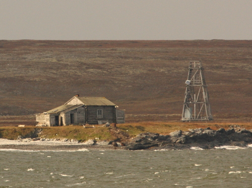
Mys Yarasalya Light, July 2010
Lightphotos.net photo by Peter and Nataliya Bogorodskie
Vaygach Island: West Coast, Kara Strait, and East Coast Lighthouses
Vaygach Island lies just off the end of the Yugorskiy Peninsula. The Yugorskiy Strait is the narrow passage between the northern end of the peninsula and Vaygach Island. The strait, a shortcut from the southeastern corner of the Barents Sea to the southwestern corner of the Kara Sea, is an alternate passage in Russia's Arctic waterway, the Northern Sea Route. Always a difficult passage, it narrows to as little as 3 km (1.9 mi) and has been known for centuries as the "Iron Gateway" to the Siberian coast. With the recent warming of the Arctic most vessels now avoid the Yugorskiy strait by sailing around the north end of Vaygach Island, which is separated from Novaya Zemlya by the 56 km (35 mi) wide Kara Strait.

Lapin (Lanuk) Nos
Date unknown. Active; focal plane 44 m (144 ft); white flash every 6 s. 33 m (108 ft) square skeletal tower carrying a daymark painted with brown and white horizontal bands. No photo available and Google's satellite view has no detail of the cape. Located on a prominent cape on the central west coast of Vaygach Island. Site status unknown. RU 2103-2016; Admiralty L7553; NGA 16558.
Ostrov Kolyubakina
Date unknown. Active; focal plane 29 m (95 ft); white flash every 4 s. 16 m (52 ft) square pyramidal wood skeletal tower, painted black with white diagonal stripes in the form of an X. No photo available and the island is only a blur in Google's satellite view. Located on a small island off the northwest coast of Vaygach Island. Accessible only by boat. Site status unknown. RU 2103-2070; Admiralty L7556; NGA 16560.
Ostrov Chirachiy
Date unknown. Active; focal plane 19 m (62 ft); one long red flash every 10 s. 10 m (33 ft) square pyramidal wood skeletal tower, painted in black and white horizontal bands. No photo available but Google has a satellite view. The light marks the south side of the west entrance to the Kara Strait. Located on a small island off the northwest coast of Vaygach Island. Accessible only by boat. Site status unknown. RU 2111-0420; Admiralty L7560; NGA 16564.
Oleniy Severo-Zapadnyy
Date unknown. Active; focal plane 25 m (82 ft); green flash every 5 s. 16 m (52 ft) square pyramidal wood skeletal tower, painted in black and white horizontal bands. No photo available but Google has a satellite view. Located on a small island off the north coast of Vaygach Island about 30 km (19 mi) west of Bolvanskiy Nos. Accessible only by boat. Site status unknown. RU 2111-0440; Admiralty L7564; NGA 16572.
Bolvanskiy Nos (1)
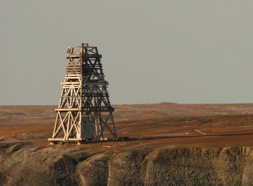
Date unknown. Apparently replaced. 20 m (66 ft) square pyramidal wood skeletal tower, painted in a black and white checkerboard pattern. Vladimir Shadwin's photo is at right, Lightphotos.net also has Roman Chudinov's photo, another photo is available, and Google has a satellite view of the station. A weather station surrounds the lighthouse. Not to be confused with the Mys Bolvanskiy Light (see the Western Nenetsia page). Located at the northern tip of Vaygach Island, marking the eastern entrance to the Kara Strait. Site status unknown.
Bolvanskiy Nos (2)
Date unknown. Active; focal plane 37 m (121 ft); one long white flash every 6 s. 20 m (66 ft) square cylindrical skeletal tower. Vladimir Shadwin's photo at right shows both towers well. Located close to the historic lighthouse. RU 2111-0385; Admiralty L7566; NGA 16568.
Mys Matyuysalya
Date unknown. Active; focal plane 21 m (69 ft); red flash every 2 s. 10 m (33 ft) square pyramidal wood skeletal tower, painted black with a white vertical stripe. No photo available and Google's satellite view has no detail in the area. Located on a cape on the northeast coast of Vaygach Island about 20 km (13 mi) southeast of Bolvanskiy Nos. Accessible only by boat. Site status unknown. Admiralty L7568; NGA 16528.
Mys Gomsasalya
Date unknown. Active; focal plane 50 m (164 ft); green flash every 4 s. 10 m (33 ft) square pyramidal wood skeletal tower, painted black with a white vertical stripe. No photo available and Google's satellite view has no detail in the area. Located on a cape on the southeast coast of Vaygach Island about 32 km (20 mi) Northwest of the Yugorskiy Strait entrance. Accessible only by boat. Site status unknown. Admiralty L7570; NGA 16524.

New (left) and old Bolvanskiy Lights, Vaygach Island, April 2014
Lightphotos.net photo by Vladimir Shadwin

Vaygach Island: Yugorskiy Strait Lighthouses
Mys Belyy Yugorskiy
Date unknown. Active; focal plane 43 m (141 ft); two red flashes every 10 s. 16 m (52 ft) square wood skeletal tower. Google's satellite view has no detail in this area. Located on a promontory on the north side of the eastern entrance to Yugorskiy Strait. Site status unknown. RU 2111-0360; Admiralty L7572; NGA 16512.
Mys Kanin
Date unknown. Abandoned; listed with focal plane 24 m (79 ft); green flash every 4 s. 10 m (33 ft) square pyramidal wood skeletal tower. Google's satellite view has no detail in this area. Located on a promontory on the north side of the strait inside the eastern entrance. Site status unknown. Admiralty L7520.
Mys Sukhoy Range Front
Date unknown. Active; focal plane 14 m (46 ft); red flash every 3 s. 11 m (36 ft) square wood skeletal tower. Artemiy Sakh's photo is at right and Google has a distant satellite view. The range guides eastbound vessels in the strait. Located on a promontory on the north side of the strait. Site status unknown. Admiralty L7499; NGA 16492.
Mys Sukhoy Range Rear
Date unknown. Active; focal plane 21 m (69 ft); red light, 2 s on, 4 s off. 11 m (36 ft) square wood skeletal tower. No photo available but Google has a distant satellite view. Located 1067 m (0.68 mi) northeast of the front light. Site status unknown. Admiralty L7499.1; NGA 16496.

Mys Sukhoy Range Front Light, Vaygach Island, September 2014
ex-Google Plus photo by Artemiy Sakh; used by permission
Yugorskiy Vkhodnoy (Mys Stvornyy) Eastbound Range Rear
Date unknown. Active; focal plane 35 m (115 ft); green light, 2 s on, 4 s off. 19 m (62 ft) square skeletal tower listed as carrying a trapezoidal daymark painted white with a red vertical stripe. Artemiy Sakh's photo is at right but Google's satellite view has no detail in this area. Located on a promontory on the north side of the strait. Site status unknown. Admiralty L7497.1; NGA 16480.
Mys Stvornyy Range Common Front
Date unknown. Active; focal plane 20 m (66 ft); green flash every 3 s. 11 m (36 ft) square pyramidal wood skeletal tower with a slatted daymark painted with black and white horizontal bands. No photo available but Google has a satellite view. Located on a headland at the narrowest passage of the Yugorskiy Strait. Site status unknown. Admiralty L7497; NGA 16479.
Stvorno-Storozhevoy Range Rear
Date unknown. Active; focal plane 33 m (108 ft); green light, 2 s on, 4 s off. 12 m (39 ft) square pyramidal wood skeletal tower with a daymark having a red vertical stripe. No photo available but Bing has a satellite view. This range guides westbound vessels. Located on a ridge 2.6 km (1.6 mi) west of the Mys Stvornyy Common Front Light. Site status unknown. Admiralty L7500.1; NGA 16480.1.
Varneka Range Front
Date unknown. Probably inactive but listed with focal plane 17 m (56 ft); yellow flash every 3 s. 11 m (36 ft) square skeletal tower carrying a slatted daymark painted white with a black vertical stripe.No photo available but the light is barely visible in Google's indistinct satellite view. The range guides vessels into Varnek Bay, site of a small village on an embayment on the north side of Yugorskiy Strait. Site open, tower closed. Admiralty L7498; NGA 16484.

Yugorskiy Vkhodnoy Light, Vaygach Island, September 2014
ex-Panoramio photo copyright Artemiy Sakh; used by permission
Varneka Range Rear
Date unknown. Probably inactive but listed with focal plane 27 m (79 ft); one long yellow flash every 6 s. 19 m (62 ft) square skeletal tower carrying a slatted daymark painted white with a black vertical stripe. No photo available but Google has an indistinct satellite view. Located about 800 m (1/2 mi) northwest of the front light. Site open, tower closed. RU 2111-0260; Admiralty L7498.1; NGA 16488.
Mys Greben
Date unknown. Active; focal plane 43 m (141 ft); white flash every 3 s. 38 m (124 ft) skeletal tower carrying a rectangular daymark painted white with a black vertical stripe. No photo available but Google has a distant satellite view. Located on the north side of the western entrance to the Yugorskiy Strait. Site status unknown. RU 2103-2000; Admiralty L7494; NGA 16450.

Yugorskiy Peninsula: Yugorskiy Strait Lighthouses
Yugorskiy Approach Range Front
Date unknown. Active; focal plane 16 m (52 ft); white flash every 3 s, visible only on the range line. 9 m (30 ft) square skeletal tower carrying a trapezoidal daymark painted white with a red vertical stripe. No photo available but Bing has a satellite view. Located on the south side of the western entrance to Yugorskiy Strait. Site status unknown. Admiralty L7496; NGA 16460.
Yugorskiy Approach Range Rear
Date unknown. Active; focal plane 31 m (102 ft); white light, 2 s on, 4 s off, visible only on the range line. 14 m (46 ft) square skeletal tower carrying a trapezoidal daymark painted white with a red vertical stripe. No photo available but Bing has a satellite view. Located 1590 m (1 mi) east of the front light. Site status unknown. RU 2111-0231; Admiralty L7496.1; NGA 16464.
Mys Glinistyy (Glinstyy) Range Front
Date unknown. Active; focal plane 38 m (125 ft); green flash every 2 s. 18 m (59 ft) square skeletal tower carrying a trapezoidal daymark painted white with a red vertical stripe. No photo available but Bing has a satellite view. This range guides westbound vessels on a north to south reach in the eastern half of the Yugorskiy Strait. Located on a promontory on the south side of the strait. Site status unknown. Admiralty L7518; NGA 16500.
 
Mys Glinistyy (Glinstyy) Range Rear
Date unknown. Active; focal plane 50 m (164 ft); green light, 2 s on, 4 s off. 22 m (72 ft) square pyramidal skeletal tower carrying a trapezoidal daymark painted white with a red vertical stripe. No photo available but Bing has a satellite view. Located 1.8 km (1.1 mi) south southwest of the front light. Site status unknown. Admiralty L7518.1; NGA 16504.
Ostrov Sokoliy
Date unknown. Active; focal plane 29 m (5 ft); yellow flash every 5 s. 7 m (23 ft) square pyramidal skeletal tower. Lightphotos.net has a view from the sea and Google has a very distant satellite view. Located on an island on the east side of the eastern entrance to the Yugorskiy Strait. Accessible only by boat. Site status unknown. Admiralty L7536; NGA 16516.

Kara Sea: South Coast Lighthouses
Mys Yarasalya (Yarossel')
Date unknown. Active; focal plane 27 m (89 ft); white light, 2 s on, 8 s off. 16 m (52 ft) octagonal brick tower on a square brick base. The lighthouse is unpainted red brick (unusual for the Arctic). A photo by Peter and Nataliya Bogorodskie is at the top of this page and Google has a satellite view of the station. Located on the south side of the eastern entrance to the Yugorskiy Strait from the Kara Sea. Site status unknown. RU 2111-0350; Admiralty L7540; NGA 16520.
Mys Tonkiy
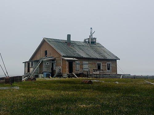
Date unknown. Reported inactive since 2010, but still listed with focal plane 32 m (105 ft); one long flash every 7.5 s, white, red or green depending on direction. 8 m (26 ft) lantern mounted on a dilapidated 1-1/2 story wood keeper's house. Peter and Nataliya Bogorodskie's photo is at right, Lightphotos.net also has Vladimir Shadrin's photo, and Google has a satellite view of the station. This directional light guides vessels westbound to the Yugorskiy Strait. Located on a sharp cape about 12 km (7.5 mi) east of Mys Yarasalya. Site status unknown. RU 2111-0710; Admiralty L7990; NGA 16532.
Ostrov Mestnyy
Date unknown. Reported inactive as of 2010; focal plane 56 m (184 ft); yellow flash every 5 s. 15 m (49 ft) square pyramidal tower, painted with black and white diagonal stripes. Lightphotos.net has Vladimir Shadrin's closeup photo but Google has only a fuzzy satellite view of the island. Located on an island about 2 km (1.25 mi) east of Mys Tonkiy. Accessible only by boat. Site status unknown. RU 2111-0720; Admiralty L8000; NGA 16536.
[Morozov Strait First and Third Range Common Front]
Date unknown. Reported inactive as of 2010; focal plane 21 m (69 ft); red flash every 2 s. 7 m (23 ft) post with two slatted daymarks for the two ranges, each painted black with a white vertical stripe. Lightphotos.net has Vladimar Shadrin's photo and Google has a very distant satellite view. The #1 range guides eastbound vessels in the Morozov Strait, between Ostriv Mestnyy and the mainland, and the #3 range guides westbound vessels. Located on the mainland opposite Ostrov Mestnyy. Site status unknown. Admiralty L8002.
Morozov Strait First Range Rear
Date unknown. Reported inactive as of 2010; focal plane unknown; red light, 2 s on, 4 s off. Approx. 12 m (39 ft) square pyramidal wood skeletal tower. The front of the tower is covered by a slatted daymark painted black with a white vertical stripe. No photo available but Google has a distant satellite view. Located about 500 m (0.3 mi) south of the common front light. Site status unknown. Admiralty L8001.9.

Mys Tonkiy Light, Kara Sea, July 2010
Lightphotos.net photo by Peter and Nataliya Bogorodskie
Morozov Strait Third Range Rear
Date unknown. Reported inactive as of 2010; focal plane 34 m (112 ft); red light, 2 s on, 4 s off. 12 m (39 ft) square pyramidal wood skeletal tower. The front of the tower is covered by a slatted daymark painted black with a white vertical stripe. Lightphotos.net has Vladimar Shadrin's view of both range lights and Google has a distant satellite view. Located about 1 km (0.6 mi) west of the common front light. Site status unknown. Admiralty L8002.1.
Morozov Strait Second Range Front
Date unknown. Reported inactive as of 2010; focal plane 20 m (66 ft); flash every 2 s, white or green depending on direction. 8 m (26 ft) square pyramidal wood skeletal tower. The front of the tower is covered by a slatted daymark painted black with two white triangles. Lightphotos.net has Vladimar Shadrin's photo but Google has only a fuzzy satellite view of the area. The range guides eastbound vessels in the Morozov Strait, between Ostriv Mestnyy and the mainland. Located on the mainland opposite Ostrov Mestnyy. Site status unknown. Admiralty L8003.
Morozov Strait Second Range Rear
Date unknown. Reported inactive as of 2010; focal plane 35 m (115 ft); white or green light, depending on direction, 2 s on, 4 s off. 10 m (33 ft) square pyramidal wood skeletal tower. The front of the tower is covered by a slatted daymark painted black with two white triangles. Lightphotos.net has Vladimar Shadrin's view of both range lights but Google has only a fuzzy satellite view of the area. Located about 1 km (0.6 mi) southeast of the front light. Site status unknown. Admiralty L8003.1.
Morozov Strait Fourth Range Front
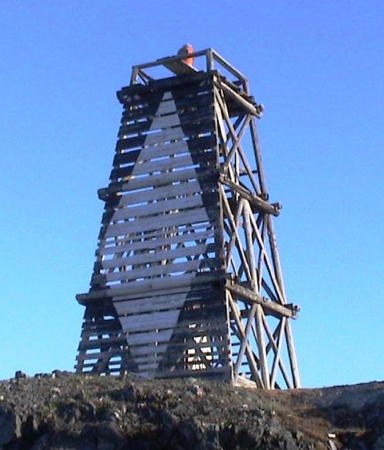
Date unknown. Reported inactive as of 2010; focal plane 20 m (66 ft); flash every 2 s, white or green depending on direction. 10 m (33 ft) square pyramidal wood skeletal tower. The front of the tower is covered by a slatted daymark painted black with a large white diamond. Lightphotos.net has Vladimar Shadrin's photo (also seen at right) but Google has only a fuzzy satellite view of the area. The range guides westbound vessels in the Morozov Strait, between Ostriv Mestnyy and the mainland. Located on the mainland opposite Ostrov Mestnyy. Site status unknown. Admiralty L8004.
Morozov Strait Fourth Range Rear
Date unknown. Reported inactive as of 2010; focal plane 43 m (141 ft); white or green light, depending on direction, 2 s on, 4 s off. 11 m (36 ft) square pyramidal wood skeletal tower. The front of the tower is covered by a slatted daymark painted black with a large white diamond. Lightphotos.net has Vladimar Shadrin's view of both range lights but Google has only a fuzzy satellite view of the area. Located about 1.25 mi (3/4 mi) southwest of the front light. Site status unknown. Admiralty L8004.1.
Amderma
Date unknown. Inactive, though still listed with focal plane 56 m (184 ft); one long green flash every 6 s. 11 m (36 ft) square skeletal tower supposedly carrying a red triangular daymark. Lightphotos.net has Vladimir Shadrin's photo, which shows that both the light and the daymark are missing from the tower. The light is barely visible in Google's distant satellite view of the area. Located on a hillside behind the village of Amderma, about 30 km (20 mi) east of Mys Tonkiy. Site status unknown. RU 2111-0761; Admiralty L8008; NGA 16540.
Shpindlera
Date unknown. Active; focal plane 50 m (164 ft); one long red flash every 8 s. 14 m (46 ft) square pyramidal wood skeletal tower, painted black with a white vertical stripe. No photo available and Google has only a fuzzy satellite view of the area. Located about 120 km (75 mi) east of Amderma. Accessible only by boat. Site status unknown. RU-2111-0770; Admiralty L8012; NGA 16548.
Vylkin Nos
Date unknown. Active; focal plane 59 m (194 ft); one long white flash every 8 s. 18 m (56 ft) square pyramidal wood skeletal tower, painted black. No photo available and Google has only a fuzzy satellite view of the area. Located about 15 miles northwest of the seasonal village of Ust'-Kara. Accessible only by boat. Site status unknown. RU-2111-0775; Admiralty L8014; NGA 16552.
Mys Tolstik
Date unknown. Active; focal plane 10 m (33 ft); red flash every 3 s. 10 m (33 ft) square pyramidal wood skeletal tower, painted with black and white horizontal bands. No photo available and Google has only a fuzzy satellite view of the area. Located in the seasonal village of Ust'-Kara, at the eastern border of Nenetsia. Accessible only by boat. Site status unknown. RU-2111-0790; Admiralty L8015.

Morozov Strait Fourth Range Front Light, Kara Sea, July 2005
Lightphotos.net photo by Vladimar Shadrin

Information available on lost lighthouses:

Adjoining pages: East: Yamalo-Nenetsia | West: Western Nenetsia

Return to the Lighthouse Directory index | Ratings key

Posted December 7, 2005. Checked and revised April 16, 2024. Lighthouses: 36. Site copyright 2024 Russ Rowlett and the University of North Carolina at Chapel Hill.