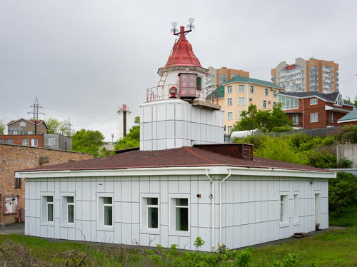
Lighthouses of Russia: Southern Primorsky Krai (Vladivostok Area)

Russia (Россия, Rossiya in Russian) is by far the world's largest country, spanning a little over 150° in longitude. It is organized as the Russian Federation (Rossiyskaya Federatsiya) with members known as federal subjects (sub'yekty federatsii). Russia is primarily a continental nation but it has important coastlines on the Baltic, Black, and Caspian Seas and very long coastlines on the Arctic Ocean and North Pacific Ocean. To guard these coasts it operates hundreds of lighthouses, many of them historic.

Primorsky Krai (known in English as the Maritime Province and usually called Primorye in Russia) is the southernmost and most populous region of Russia's far eastern coast. Its name Приморский край literally means "Seaside Edge." This page covers lighthouses in the southern portion of the province including the major port of Vladivostok and the Khasansky District, which extends in a narrow coastal corridor bordering China to the west and North Korea to the south.

Russian occupation of this area began with the explorations of Vitus Bering and Alexsei Chirikov between 1728 and 1741 but settlements were few until treaties with China brought the Primorsky Krai under Russian control in the 1850s.

The Russian word for a lighthouse is mayak (маяк); ostrov is an island, poluostrov is a peninsula, kosa is a sandy spit, rif is a reef, mys is a cape, bukhta is a bay, zaliv is a larger bay or gulf, proliv is a strait, reka is a river, and gavan' is a harbor.

Russian lighthouses are owned by the Russian Navy and maintained by the Office of Navigation and Oceanography (Управление навигации и океанографии).

ARLHS numbers are from the ARLHS World List of Lights. Admiralty numbers are from volume M of the Admiralty List of Lights & Fog Signals. U.S. NGA List numbers are from Publication 112.


Bryusa Light, Slavyanka, May 2014
ex-Panoramio photo copyright Igor Bushin; used by permission

General Sources
Lighthouses of Khasan District
A translation of a document posted by the Khasansky District government, with three photos.
Russian Lighthouse Society
Photos and information on many lighthouses.
Lighthouses of the USSR - Far Eastern Seas
This Russian-language reference provides valuable historical information.
Lighthouses of Vladivostok and Primorye
This Russian-language site has photos and information on the major lighthouses in the area.
Lighthouses in the Russian Far East
Photos by various photographers available from Wikimedia.
World of Lighthouses - Russia Far East
Photos by various photographers available from Lightphotos.net.
Online List of Lights - Russia - Pacific Coast
Coming soon: photos by various photographers posted by Alexander Trabas.
Russische Leuchttürme auf historischen Postkarten
Postcard views of historic Russian lighthouses posted by Klaus Huelse.
OpenSeaMap
Navigational chart information for this area.
Navionics Charts
Navigational chart for the Maritime Province.
Fokino District Lighthouses
Fokino is a "closed town" under direct federal jurisdiction because it includes sensitive base facilities for the Russian Pacific Fleet. At the southern end of the town is Mys Sysoyeva, a prominent cape about 50 km (30 mi) southeast of Vladivostok and a similar distance west of Nakhodka. Ostrov Askol'd is an island about 12 km (7.5 mi) south of the cape. This is a dangerous area for ships approaching either Vladivostok or Nakhodka. Strelok Bay is east of Mys Sysoyeva and is sheltered by a large island, Ostrov Putyatina. Although the mainland part of Fokino is closed the islands of Askol'd and Putyatina are open. Askol'd is uninhabited and rarely visited but ecotours to Putyatina are available from Vladivostok.
Ostrov Nikol’skogo
Date unknown. Inactive. 6 m (20 ft) octagonal tower painted white. A view from the beach is available and Google has a satellite view. Located at the west end of an island sheltering a harbor on the east side of Pavlovskogo Bay. Site status unknown.
Zaliv Strelok East Passage Range Front (Mys Strelok)
Date unknown. Probably inactive but listed with focal plane 44 m (144 ft); yellow light, 1 s on, 1 s off. 14 m (46 ft) square concrete tower, painted white with a red vertical stripe. Wikimapia has photos including Serg Burakov's photo at right, Alena Muzychenko has a 2017 photo, Vyacheslav Litovchenko has a 2018 view, and Bing has a satellite view. The lighthouse appears abandoned in the photos. This range guides ships in the passage east of Ostrov Putyatina. Located on Mys Strelok, a promontory at the east entrance to Abrek Bay, the harbor of Fokino. Site presumably closed. Admiralty M7529.5.
Zaliv Strelok Range Common Rear
Date unknown. Active (?); focal plane 116 m (381 ft); continuous light, red for the Western Approach Range and yellow for the East Passage Range. 16 m (52 ft) octagonal concrete tower, painted white with black vertical stripes. A 2013 closeup photo and a distant view are available and Bing has a satellite view. This tower carries the rear light of the Zaliv Strelok Western Approach and East Passage Ranges. Located atop a steep bluff at the northern head of Abrek Bay. Site presumably closed. Admiralty M7529.31.
Zaliv Strelok Western Approach Range Front
Date unknown. Active (?); focal plane 61 m (200 ft); red light, 1.5 s on, 1.5 s off. 10 m (33 ft) square concrete tower, painted white with a black vertical stripe. No photo available but Google has a satellite view. This range guides ships around the west side of Ostrov Putyatina. Located on the west side of Abrek Bay about 5 km (3 mi) south of Fokino. Site presumably closed. Admiralty M7529.3.
Mys Abrek (2)
Date unknown. Inactive, probably since around 1980. 5 m (17 ft) octagonal tower, painted white. A 2013 photo is available and Bing has a satellite view. A 1973 light list describes the light as a 5 m (17 ft) skeletal tower providing a focal plane height of 15 m (49 ft). Located on the tip of a sharp promontory at the western entrance to Abrek Bay. Site status unknown. ex-Admiralty F7546 (lights of the Russian Pacific have since been moved from volume F to volume M).
Bukhta Konyushkova Range Front
Date unknown. Active; focal plane 31 m (102 ft); continuous red light. 11 m (36 ft) square stone tower painted white with a black vertical stripe. Google has a distant street view and Bing has a satellite view. Konyushkova Bay is a small harbor on the mainland south of Dunay and to the west of Ostrov Putyatina. The range guides ships southbound into the harbor. Located on the hillside above the harbor. Site status unknown. Admiralty M7528.5.

Mys Strelok Light, Fokino
Wikimapia Creative Commons photo by Serg Burakov
Bukhta Konyushkova Range Rear
Date unknown. Active; focal plane 51 m (167 ft); continuous red light. 9 m (30 ft) square stone tower painted white with a black vertical stripe. No photo available but Bing has a satellite view. Located about 200 m (220 yd) southwest of the front light. Site status unknown. Admiralty M7528.51.
[Kamen' Baklaniy]
Date unknown. Active; focal plane 6 m (20 ft); red light, pattern unknown. 3 m (10 ft) square stone tower. Alisa Lazar' has a photo and Google has an indistinct satellite view. Located on an isolated rock in the entrance to the Strelok Bay West Passage. Accessible only by boat. Site and tower open. Admiralty M7505.
Yelagina (Mys Yelagina, Ostrov Askold) (3)
1976 (station established 1881). Active; focal plane 113 m (371 ft); white light, 1.5 s on, 4.5 s off. 8 m (26 ft) octagonal cylindrical masonry tower with lantern and gallery, attached to the seaward side of a ramshackle masonry keeper's house. 5th order (?) Fresnel lens. Tower painted white, lantern red. Lightphotos.net has Vladimir Serebryanskiy's photo, Kira Gornostaeva has a foggy photo of both lighthouses, Evgeniy Kan has a distant street view from the earlier lighthouse, and Google has an indistinct satellite view of the station. A 2019 photo shows the lighthouse to be in terrible condition; a 2021 photo shows limited improvement. The first lighthouse was a 16.5 m (54 ft) brick tower with a focal plane of 180 m (590 ft); it was the first lighthouse built on Russia's Pacific Coast. The present lighthouse appears to be in very poor condition. Located on the south point of Ostrov Askol'd. Site status unknown. ARLHS ASR-075; Admiralty M7502; NGA 16052.
Yelagina (Mys Yelagina, Ostrov Askold) (2)
1917 (station established 1881). Inactive since 1976 and in ruins. Approx. 16 m (52 ft) octagonal cylindrical stone tower. A photo is at right, Maxim Starovoitov has a 2018 photo, Lightphotos.net has a closeup, Evgeniy Kan has a street view, and Google has a satellite view. Site status unknown; the path to the lighthouse includes a crumbling and perilous stairway.

1917 Ostrov Askold Light
photo by RIA PrimaMedia
Mys Stupenchatyy
Date unknown. Abandoned but listed with focal plane 27 m (89 ft); white flash every 8 s. 5 m (17 ft) square concrete tower, painted white. Roger Reyneke has a 2021 closeup photo and Google has a satellite view. Located on the northern tip of Ostrov Askol'd. Accessible only by boat. Site open, tower closed. ARLHS ASR-110; Admiralty M7503; NGA 16053.
Sysoyev (Mys Sysoyeva) (2)
1972 (station established 1938). Active; focal plane unknown; white light, 1.5 s on, 1.5 s off. 8 m (26 ft) octagonal cylindrical tower with lantern and gallery, painted red. The photo is at right is from a 2016 photo article by Maxim Kalennik for a Vladivostok news service, Lighthouses of the USSR has a page for the light station, a 2019 photo is available, Lightphotos.net has a photo of the station by Vladimir Serebryanskiy, a distant view and a panoramic view (third photo on the page) are available, and Google has a satellite view. The first light was on a 5 m (16 ft) tower. Located on the point of the cape south of Dunay. Site and tower closed (restricted military area). ARLHS ASR-111; Admiralty M7528; NGA 16056.

Shkotovsky District (Bolshoy Kamen' Area) Lighthouses
Ussuri Bay is the broad inlet east of Vladivostok; the northern portion of the gulf is also called Shamora Bay or Lazunura Bay. Bolshoy Kamen' ("Big Stone") is a port on the east side of Shamora Bay. The city has a naval base and was closed to foreign visitors for many years, but its closed status was terminated in 2015.

Mys Sedlovidnyy
Date unknown. Active; focal plane at least 40 m (131 ft); white light, pattern unknown. Approx. 12 m (39 ft) square pyramidal metal tower painted red. Svetlana Kuznetsova has a 2019 closeup photo and a panoramic view and Google has a satellite view. Located atop a sharp promontory about 8 km (5 mi) south of Bolshoy Kamen'. Site open, tower closed. Admiralty M7496.
Bolshoy Kamen' Range Front
Date unknown. Active; focal plane unknown; red flash every 3 s. 14 m (46 ft) square concrete tower, painted white with a black vertical stripe. A 2018 photo and a 2021 photo are available and Google has a satellite view. This is the entrance range for the main harbor of Bolshoy Kamen'. Located on a hillside surrounded by apartment blocks and two taller buildings, about 1500 m (1 mi) southeast of the harbor. Site open, tower closed. Admiralty M7490.
Bolshoy Kamen' Range Rear
Date unknown. Active; focal plane 107 m (351 ft); continuous red light. 13 m (43 ft) square concrete tower, painted white with a black vertical stripe. A 2018 closeup photo is available and Google has a satellite view. Located about 1.8 km (1.1 mi) southeast of the front light. Site open, tower closed. Admiralty M7490.1.

Mys Sysoyeva Light, Dunay, June 2016
photo by Sergei Orlov (no longer online) for newsvl.ru
reproduction permitted with attribution
Mys Maximova
Date unknown. Active; focal plane 37 m (121 ft); white light, 3 s on, 3 s off. 8 m (26 ft) square brick tower, painted white with one red horizontal band. Andrey Alimpiev has a photo, a closeup 2018 photo is available and Google has a satellite view. Located on a cape about 1 km (0.6 mi) north of the harbor of Bolshoy Kamen'. Site and tower closed. Admiralty M7489.
Mys Krasnyy
Date unknown. Active; focal plane 30 m (98 ft); one long white flash every 7.5 s. 6 m (20 ft) square brick tower, painted white with one red horizontal band. Nadezhda Krasnoselskikh has a 2018 photo and Google has a satellite view. Located on a cape at Sukhodol, about 5 km (3 mi) north of Bolshoy Kamen'. Site and tower closed. Admiralty M7488.

Vladivostok City Lighthouses
Vladivostok (the name means "Ruler of the East") was founded in 1860, soon after China ceded the territory of the Maritime Province to Russia. In 1916 the Trans-Siberian Railroad was completed, linking Vladivostok to Moscow. The city is built at the end of the Muravyov-Amursky Peninsula, which together with Ostrov Russkiy and associated islands divides the Amur Bay on the west from the Ussuri Bay on the east. Vladivostok is the traditional home port of Russia's Pacific Fleet and during the Soviet era it was generally closed to foreigners. It is open today, although some areas are restricted. Early settlers thought the city's harbor was like that of the Golden Horn harbor of İstanbul (Constantinople), so they named it Zolotoy Rog (Golden Horn) Bay. The strait separating the city from Russkiy Island is called the Bosfor Vostochny (Eastern Bosporus) Strait.

Basargin (Mys Basargina) (4)
1958 (fog signal station established 1922, light established 1937). Active; focal plane 28 m (92 ft); green light occulting once every 7.5 s. 8 m (26 ft) octagonal stone tower with gallery and a small lantern, painted with red and white horizontal bands. Perched on a huge rock just offshore, the lighthouse is connected to the mainland by a swinging footbridge. A photo by D. Robertovitch is at right, Lighthouses of the USSR has a page with a good photo and the history of the light station, the Lighthouse Society also has a page, Wikimedia has Lena Jaginyan's 2019 photo, Sergei Shaderkin has a fine photo, Jura Semejkin has a good photo, Alexey Suvorov has a view from the sea, the light was featured on a 1984 Soviet postage stamp, Huelse has a historic postcard view, and Google has a satellite view. This lighthouse replaced a series of insubstantial wood towers. It is named for Vladimir Basargin, the naval officer who carried out the first hydrographic survey of the area in 1861. Located on a rock on the north side of the eastern entrance to the Bosfor Vostochny Strait, about 10 km (6 mi) east southeast of the Tokarev lighthouse. Site and tower closed. . ARLHS ASR-015; Admiralty M7471; NGA 16167.


Basargin Light, Vladivostok, June 2012
ex-Panoramio photo copyright D. Robertovitch; permission requested

* Shkotovskiy (Proliv Bosfor Vostochnyy) Range Front (2)
1954 (station established 1928). Active; focal plane 32 m (105 ft); continuous red light. 15 m (49 ft) square tower with an octagonal lantern room, rising from a square keeper's house. Lighthouse painted white. Igor Savitskiy's 2024 photo is at right, Maxim Pismak' has a wintry 2010 photo, Lighthouses of the USSR has a page for the range lights including a photo that shows all three of them, a closeup and a more distant view are available, a page for the range has photos, the lighthouse is seen in Wikimedia's photo of the middle light, Jean Grudachev has an excellent street view, and Google has a satellite view. This range guides ships through the Bosfor Vostochnyy ("Eastern Bosporus") Strait on the approach to Vladivostok from the east. The range is named for Capt. Nikolai Shkota, who commanded the Russian naval base in Vladivostok in 1864-66. Located about 1.5 km (1 mi) northeast of the Tokarev lighthouse. Site appears open, tower closed. ARLHS ASR-156; Admiralty M7472; NGA 16169.
* Shkotovskiy (Proliv Bosfor Vostochnyy) Range Middle (2)
1954 (station established 1933). Active; focal plane 50 m (164 ft); red light occulting once every 3 s. 15 m (49 ft) octagonal stone tower, painted white with a black vertical stripe on the range line. Igor Savitskiy contributed a 2024 photo, lighthouse is seen at the right in a photo of the front light, a good photo from the back is available, Wikimedia has a photo, a page for the range has photos, and Google has a street view and a satellite view. Located 125 m (410 ft) west northwest of the front light. Site open, tower closed. ARLHS ASR-157; Admiralty M7472.01; NGA 16169.1.
* Shkotovskiy (Proliv Bosfor Vostochnyy) Range Rear
1954. Active; focal plane 69 m (226 ft); continuous red light. 15 m (49 ft) octagonal tower, painted white with a black vertical stripe on the range line. Igor Savitskiy contributed a 2024 photo, a page for the range has photos and Google has a street view and a satellite view. Located on a ridge crest 400 m (1/4 mi) west northwest of the middle light. Site open, tower closed. ARLHS ASR-158; Admiralty M7472.02; NGA 16169.2.

Bosfor Vostochnyy Range Front Light, Vladivostok, May 2024
photo copyright Igor Savitskiy; used by permission
* Tokarev (Egersheld)
1913. Active; focal plane 12 m (39 ft); one long flash every 7.5 s, white or red depending on direction. 12 m (39 ft) cylindrical stone tower with lantern and gallery; the lower half of the tower is octagonal and the upper half is round. Lighthouse painted white. Vitaly Trusov's photo is at right, Igor Savitskiy contributed a 2024 photo, Lighthouses of the USSR has a page with several good photos, Alexander Smerdov has another good closeup, Lisa Walker has a 2007 closeup, the Lighthouse Society has a photo and a historic image, Huelse has a historic postcard photo, Alexander Fedoreyev has a closeup street view, and Google has a satellite view. Despite its modest size this is one of Russia's best known lighthouses. It is named for Capt. M.J. Tokarev, whose ship surveyed the area in 1862-63. In recent years the tower has been dwarfed by a 152 m (499 ft) modern skeletal tower that carries power lines across the Vladivostok harbor entrance. Located at the end of a mole at the entrance to Vladivostok harbor and at the extreme southwestern tip of the Egersheld Peninsula. Accessible in good weather by a hike of about 3 km (2 mi) from the end of the city's bus line. However, the access to the lighthouse is underwater at high tide. Site open, tower closed. . ARLHS ASR-008; Admiralty M7479; NGA 16169.92.
Mys Rosseta
1956. Active; focal plane 66 m (217 ft); green light occulting once every 15 s. The light is mounted at the gable end of a 1-story masonry building, and there is a backup light on a short skeletal mast in front of the building. Igor Savitskiy contributed a 2024 photo, Lighthouses of the USSR has a page for the lighthouse, a closeup photo is available, and Google has a satellite view. The cape is named for Lt. Sergei Rosset, who was known for his surveys on the Amur estuary and elsewhere in the Russian Far East during the 1880s. Located on a steep ridge on the west side of the Egersheld Peninsula, close to the Shkotovskiy Range Rear Light (see above) but facing the opposite direction. Site status unknown. Admiralty M7478; NGA 16169.91.
Gavan' Likhternaya Vtoroy Range Front
Date unknown. Active; focal plane 18 m (59 ft); continuous yellow light. 8 m (26 ft) square concrete tower, painted white with a black vertical stripe. Wikimapia has photos and Google has a street view, but the lighthouse is inconspicuous in Google's satellite view. The range guides vessels into the Likhternaya harbor on the west (Amur Bay) side of Vladivostok. Located beside the M60 expressway in northern Vladivostok. Site status unknown, but the light is easy to see from the highway. Admiralty M7450.
Gavan' Likhternaya Vtoroy Range Rear
Date unknown. Active; focal plane 37 m (121 ft); yellow light, 3 s on, 3 s off. Lantern mounted atop a 5-story apartment building. Google has a street view and a satellite view. Located 105 m (345 ft) east of the front light. Site open, tower closed. Admiralty M7450.01.

Tokarev Light, Vladivostok, May 2021
Google Maps photo by Vitaly Trusov

Eugénie Archipelago (Ostrov Russkiy Area) Lighthouses
Russkiy (or Russky) Island is a large island on the south side of the Bosfor Vostochny Strait. Novik Bay is a fjord that nearly cuts the island in two. A short canal connects the strait and the lower end of Novik Bay. In 2007 plans were announced to develop the island as a tourist destination and in 2008 the government ordered the building of the Russkiy Bridge, the longest cable-stayed bridge in the world, to connect the island to the mainland. The bridge opened in July 2012. Russkiy is the largest island of the Eugénie Archipelago. The islands are all included in the City of Vladivostok.
Skrypleva (2)
1899 (station established 1877). Active; focal plane 54 m (177 ft); red flash every 15 s. 12 m (39 ft) octagonal cylindrical stone tower with lantern and gallery, attached to the south side of a 1-story keeper's house. Lighthouse painted white; lantern roof is gray. A photo is at right, another page for the lighthouse is available, Lighthouses of the USSR has a view from the sea, Lightphotos.net has Sergey Orlov's view from the sea, and Google has a satellite view. This light and the Basargin lighthouse (see above) frame the eastern entrance to the Bosfor Vostochny Strait. The present lighthouse was largely rebuilt after World War II; it was restored in the early 2000s but recent photos show that it needs additional attention. Ruins of the original lighthouse are reported to be found on the island. The lighthouse is named for Rear Adm. Constantine Skrypleva, a high commander in the Russian fleet in the 1870s. Located on Ostrov Skrypleva, a small island on the south side of the entrance to the strait, about 10 km (6 mi) east southeast of the Tokarev lighthouse. Accessible only by boat. Site and tower closed. ARLHS ASR-006; Admiralty M7470; NGA 16166.
Ostrov Verkhovsky (Verkovskogo)
Date unknown. Active; focal plane 38 m(125 ft); three white flashes every 10 s. 7 m (23 ft) octagonal concrete tower painted white. Alisa Lazar' has a view from below, a page for the island has a photo and a view from the sea (halfway down the page), Wikimedia also has a view from the sea, and Google has a satellite view. Located on an islet about 5 km (3 mi) south of Ostrov Shkota, a smaller island off the southern tip of Russkiy. Accessible only by boat. Site and tower closed. ARLHS ASR-116; Admiralty M7498; NGA 16160.
Skrypleva Light
Skrypleva Light, Ostrov Russkiy, July 2006
photo copyright Вячеслав Вячеслав; used by permission
Ostrov Shkota
Date unknown. Inactive, although still listed with focal plane 55 m (180 ft); green flash every 3 s. 5 m (17 ft) octagonal concrete tower, painted white. A July 2016 photo shows that the light has been abandoned and Google has an indistinct satellite view. Shkota, a smaller island off the southern tip of Ostrov Russkiy, is connected to Russkiy by a bridge. Located atop a vertical cliff at the southern tip of Ostrov Shkota. Site status unknown. Admiralty M7434.3.
Proliv Starka
Date unknown. Active; focal plane 12 m (39 ft); red flash every 5 s. 6 m (20 ft) octagonal concrete tower, painted white. Ivan Vakorin has a 2021 photo, a 2018 photo is available and Google has a distant satellite view of the site. Proliv Starka (Starka Strait) is the narrow passage separating Russkiy from the neighboring Ostrov Popova to the southwest. Located on a promontory on the north side of the strait, marking the narrowest point of the passage. Site open, tower closed. Admiralty M7435.3.
Mys Vasil'yeva
Date unknown. Active; focal plane 43 m (141 ft); whte flash every 3 s. 5 m (17 ft) octagonal tower, painted white. A closeup photo is available and Bing has a distant satellite view. Note: there is a more substantial Mys Vasil'yeva lighthouse on Paramushir in the Kuril Islands. Located on a promontory near the southwestern tip of Russkiy. Site status unknown. Admiralty M7435.5; NGA 16170.3.
Mys Yermolayeva
Date unknown. Active; focal plane 7 m (23 ft); two red flashes every 6 s. 7 m (23 ft) concrete tower mounted on a square concrete pier. Alexander Fedoreyev has a very distant sea view and Google has a satellite view and a very distant street view. Located on a reef off the cape, on the north side of Novik Bay about 800 m (1/2 mi) south of the entrance to a canal that provides a shortcut between Novik bay and the Bosfor Vostochny Strait. Accessible only by boat. Site and tower closed. Admiralty M7441.

Nadezhdinsky District Lighthouse
[Ostrov Rechnoy]
1886. Inactive. Ruins of a former stone lighthouse, described in a 1904 light list as a yellow stone tower and in a 1920 light list as a gray stone tower. A photo is available and Google has a satellite view of the ruins. Located at the southwestern tip of an island at the head of the Amur Bay, about 20 km (13 mi) northwest of Vladivostok.

Ostrov Shkota Light, Vladivostok, January 2022
photo copyright Igor Savitskiy; used by permission

Khasan District Lighthouses
Sidiminskiy (Ostrov Krolichiy, Bezverkhovo) (2)
1952 (station established 1935). Active; focal plane 34 m (108 ft); red light, 3 s on, 3 s off. 9 m (30 ft) square tower with gallery, painted white. The Khasan District's photo is at right, Oleg Novakov has a view from the sea and Google has an indistinct satellite view. The original lighthouse was a square skeletal tower. Bezverkhovo is a port at the western entrance to the Amur Bay, leading to Vladivostok. Located on the southeastern side of an island about 2 km (1.25 mi) southeast of Bezverkhovo. Accessible only by boat. Site status unknown. Admiralty M7434.2.
* Bryusa (Cape Bruce, Mys Byusse)
1913. Active; focal plane 66 m (217 ft); white, red or green light depending on direction, 6 s on, 6 s off. 10 m (33 ft) square stone tower, attached to the seaward side of a 1-story keeper's house, painted white. Igor Bushin's photo is at the top of this page, Lighthouses of the USSR has a page for the lighthouse, Sergey Petrov has a 2021 drone view, Wikimedia has V. Kotelnikov's photo, Lightphotos.net has a photo of the station by Vladimir Serebryanskiy that also shows a reserve light on the hillside behind the lighthouse, the Khasan District's lighthouse history page also has a photo, Konstantin Vostrikov has a view from the sea, and Google has a satellite view of the station. Bushin's photo shows that the lighthouse was beautifully restored in 2013. The cape was named for the British admiral Sir Henry William Bruce by a British fleet searching the area for Russian ships in 1855, during the Crimean War. Located on a headland about 10 km (6 mi) east of Slavyanka and 50 km (30 mi) southwest of Vladivostok. Site status unknown. ARLHS ASR-018; Admiralty M7434; NGA 16172.
* Mys Klerka
Date unknown. Probably inactive but listed with focal plane 75 m (246 ft); red flash every 4 s. 7 m (23 ft) post mounted atop an octagonal concrete tower. Tower painted white. A 2014 photo of the abandoned light is available and Google has a satellite view. Located on a cape about 16 km (10 mi) south of Slavyanka. The area is accessible by road. Site open, tower closed. Admiralty M7430; NGA 16188.


Sidiminskiy Light, Bezverkhovo
Khasan district government photo

Bol'shoy Pelis (Ostrova Rimskogo-Korsakova)
Date unknown. Active; focal plane 194 m (636 ft); white flash every 3 s. 13 m (43 ft) square skeletal tower. No photo available but Bing has an indistinct satellite view. Located on a substantial island about 15 km (9 mi) southeast of Mys Klerka and 25 km (15 mi) northeast of Mys Gamova. Accessible only by boat. Site status unknown. Admiralty M7428; NGA 16192.
** Gamova (Cape Gamow, Mys Gamova)
1906 (F.F. Postnikov). Active; focal plane 68 m (223 ft); two white flashes every 15 s. 20 m (62 ft) round stone tower with dwelling, painted white. A 5th order (?) clamshell Fresnel lens is in use. Several staffed keeper's houses and other buildings. Elena Ovchinnikova's photo is at right, Lighthouses of the USSR has a page for the lighthouse, Anton Gorelov has a 2017 photo, Denis Ivasenko has a closeup photo, Denis Ivasenko has a good photo of the station, Lightphotos.net has Vladimir Serebryanskiy's photo, and Google has a satellite view of the station. Construction of the lighthouse began in 1898 but completion was delayed by the Russo-Japanese War of 1904-05. The cape is named for Dmitry Gamow, a young naval officer who surveyed the area in 1852-54. Located on a prominent cape about 80 km (50 mi) southwest of Vladivostok and 50 km (30 mi) northeast of the Korean border. Site open, tower open by arrangement with the staff (one source says the charge is 20 rubles). ARLHS ASR-026; Admiralty M7422; NGA 16196.
Mys Slychkova
2000. Active; focal plane 41 m (135 ft); one long red flash every 6 s. 5 m (17 ft) octagonal concrete tower, painted white. Artyom Shcherbakov has a closeup photo, a very distant view from the sea is available and Google has a satellite view. Located on the tip of a sharp promontory sheltering the bay of Zarubino. Site status unknown. Admiralty M7421.6.
Mys Degera
Date unknown. Clearly abandoned, but listed with focal plane 73 m (240 ft); green flash every 4 s. 5 m (17 ft) octagonal concrete tower, originally painted white with a red horizontal band. All the paint has worn off, as seen in Maxim Starovoitov's 2018 photo and a second photo. Google has a distant satellite view. Located on a promontory marking the approach to Posyet Bay. Site status unknown. Admiralty M7421.5.
Bukhta Postovaya Range Front
Date unknown. Active; focal plane 21 m (69 ft); red flash every 3 s. 12 m (39 ft) round cylindrical concrete tower, painted white with a black vertical stripe. A photo is available and Google has a satellite view and a closeup street view. Located on the north side of Posyet Bay opposite the Nazimova lighthouse. Site status unknown. Admiralty M7421.4.
Bukhta Postovaya Range Rear
Date unknown. Active; focal plane unknown; continuous red light. Approx. 6 m (20 ft) round cylindrical concrete tower, painted white with a black vertical stripe. Google has a satellite view and a distant street view. Located 200 m (220 yd) behind the front light. Site status unknown. Admiralty M7421.41.

Gamova Light, Khasan District, August 2021
Google Map photo by Elena Ovchinnikova
Nazimova (2)
1898. Active; focal plane 19 m (62 ft); white or red light, depending on direction, 1.5 s on, 1.5 s off. Approx. 7 m (23 ft) round cast iron tower with lantern, painted white. Keeper's house and other buildings. Alexey Panov has a view from the nearby beach, there is also a distant view of this light in the first photo of the Khasan District's page on the history of the district's lighthouses, and Google has a distant satellite view. According to the District's history, the lighthouse is a prefabricated French tourelle, and it was restored in 1956. Located on a rock at the end of the Nazimov Spit, which nearly closes off the entrance to Posyet (Pos'eta) Bay north of Khasan and about 50 km (30 mi) northeast of the Korean border. Site open, tower reported open by arrangement with the keepers. ARLHS ASR-153; Admiralty M7421.
Tumen River (Maritime Border) Range Front
Date unknown. Active; focal plane 39 m (128 ft); white, red or green light, depending on direction, occulting once every 4 s. 38 m (125 ft) square cylindrical skeletal tower. The front of the tower carries a slatted daymark painted white with a red horizontal stripe. No photo available but Google has a satellite view. This range defines the border between Russia and North Korea at sea. The rear light is in North Korea. Located beside the Tumen River, which is the North Korean border. Site and tower closed. Admiralty M7420; NGA 16198.

Information available on lost lighthouses:

Notable faux lighthouses:

Adjoining pages: North: Eastern Primorsky Krai | South: Eastern North Korea

Return to the Lighthouse Directory index | Ratings key

Posted May 19, 2006. Checked and revised April 8, 2023. Lighthouses: 41. Site copyright 2023 Russ Rowlett and the University of North Carolina at Chapel Hill.