Lighthouses of Russia: Sakha Republic (Yakutia)

Russia (Россия, Rossiya in Russian) is by far the world's largest country, spanning a little over 150° in longitude. It is organized as the Russian Federation (Rossiyskaya Federatsiya) with members known as federal subjects (sub'yekty federatsii). Russia is primarily a continental nation but it has important coastlines on the Baltic, Black, and Caspian Seas and very long coastlines on the Arctic Ocean and North Pacific Ocean. To guard these coasts it operates hundreds of lighthouses, many of them historic.

Russia's Northern Sea Route (Sevmorput) is a well developed sea lane extending through the Arctic Ocean to connect the Atlantic and Pacific. The route extends from Murmansk at the northwestern corner of Russia past the island of Novaya Zemlya and parallel to the Siberian coast all the way to the Bering Strait.

The Sakha Republic, also called Yakutia, is a unit of the Russian Federation covering a vast area of Siberia. Nearly as large as India, it would be the world's eighth largest country if were independent. Its Arctic coastline faces the Laptev Sea to the northwest and the East Siberian Sea to the northeast, the two seas being separated by the New Siberian Islands.

The Soviet Union established scores of lights along these waters but practically no information is available concerning them. Additional information is needed and would be welcome.

The Russian word for a lighthouse is mayak (маяк); ostrov is an island, poluostrov is a peninsula, mys is a cape, bukhta or guba is a bay, zaliv is a larger bay or gulf, proliv is a strait, reka is a river, and gavan' is a harbor.

Russian lighthouses are owned by the Russian Navy and maintained by the Navy's Office of Navigation and Oceanography (Управление навигации и океанографии).

The ARLHS World List of Lights does not list any of the lighthouses in the Sakha Republic. Admiralty numbers are from volume L of the Admiralty List of Lights & Fog Signals (although this is one of the few coasts in the world not well covered by that list). U.S. NGA numbers are from Publication 115.

General Sources
World of Lighthouses - Arctic Coast of Russia
Photos available from Lightphotos.net.
Online List of Lights - Russia - Arctic Sea Coast
Photos by various photographers posted by Alexander Trabas.
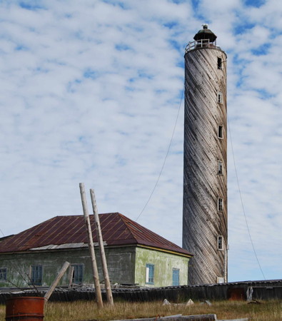
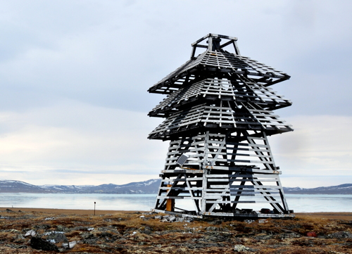
Ostrov Muostakh Light
Ostrov Muostakh Light, Tiksi, summer 2012
photo copyright Dr. Thomas Opel; used by permission
Khatanga Gulf (Nordvik Area) Lighthouses
The Khatanga Gulf is a 220 km (135 mi) long estuary at the base of the Taymyr Peninsula; it forms part of the boundary between the Sakha Republic and the Taymyria district of Krasnoyarsk province. An island, Ostrov Bol'shoy Begichev, separates the mouth of the gulf into two straits, northern and eastern. The only settlement on the gulf was Nordvik, on the eastern strait, which began as a gulag prison camp in the 1930s and continued as a salt mining camp until the mine was closed in 1956. It is unlikely that any of the lights on the gulf are active.
Ostrov Malyy Begichev
Date unknown. Active (?); focal plane 27 m (89 ft); white light, 2 s on, 4 s off. 11 m (36 ft) square pyramidal wood tower. Svetlana Evfratova has a photo but the light is not seen in Google's satellite view. Located on an island in the center of south entrance to the northern strait. Site status unknown. NGA 17476.
Mys Otmelyy
Date unknown. Active (?); focal plane 70 m (230 ft); white flash every 3 s. 13 m (43 ft) square pyramidal wood tower, black with a white vertical stripe. No photo available and Google has only a distant satellite view of the area. Located on a promontory on the south side of the gulf, marking the junction of the two straits. Site status unknown. NGA 17484.
Kumakhtah
Date unknown. Active (?); focal plane 30 m (98 ft); white flash every 2 s. 12 m (39 ft) square pyramidal wood tower. No photo available and Google has only a distant satellite view of the area. Located on the south shore of the eastern strait. Site status unknown. NGA 17500.
Solyanaya Sopka (Solyanaya Hummock)
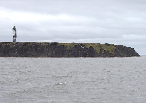
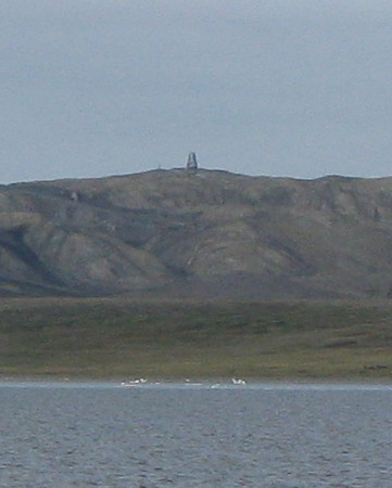
Date unknown. Active (?); focal plane 132 m (433 ft); white flash every 4 s. 7 m (23 ft) square pyramidal wood tower, black with a white vertical stripe. The light is visible in Vladislav Kyamyarya's distant view at right and Lightphotos.net has the same photo but Google has only a distant satellite view of the area. Located on a ridge behind (north of) the abandoned Nordvik settlement (some of the buildings of the camp can also be seen along the shoreline in the photo). Site status unknown. NGA 17504.
Mys Medvezhiy
Date unknown. Active (?); focal plane 56 m (184 ft); white flash every 5 s. 8 m (26 ft) square pyramidal wood tower, black with a white vertical stripe. Lightphotos.net has Vladislav Kyamyarya's very distant view from the sea but clouds obscure Google's satellite view of the area. Located on the southern tip of Ostrov Bol'shoy Begichev, marking the north side of the 10 km (6 mi) wide eastern entrance to the gulf. Site status unknown. NGA 17520.
Mys Paksa
Date unknown. Active (?); focal plane 29 m (95 ft); white light, 2 s on, 6 s off. 10.5 m (34 ft) square pyramidal wood tower. A view from the sea (first large photo on the page) is available but Google has only a distant satellite view of the cape. Located on a sharp promontory of the mainland, marking the south side of the eastern entrance to the gulf. Site status unknown. NGA 17516.
Peschanyy Vostochnyy
Date unknown. Active (?); focal plane 20 m (66 ft); white light, 2 s on, 4 s off. 18 m (59 ft) square pyramidal wood tower. No photo available and Bing has only a fuzzy satellite view of the island. Located on an isolated island in the Laptev Sea about 105 km (65 mi) east northeast of Mys Paksa, marking the approach to the gulf. Accessible only by boat. Site status unknown. NGA 17524.
Solyanaya Sopka Light
Solyanaya Sopka Light, Nordvik, August 2008
ex-Panoramio Creative Commons photo by Vladislav Kyamyarya

Lena Delta Lighthouses
The Lena River, easternmost of the three great rivers of Siberia, has formed one of the world's largest deltas as it empties into the Laptev Sea. This delta is recognized as an important ecosystem and most of it is set aside as a wildlife reserve, the largest such reserve in Russia. The delta covers an area of about 83,000 km2 (32,000 mi2).

Ayeros'yemka
Date unknown. Active; focal plane 20 m (66 ft); white light, 2 s on, 6 s off. 18 m (59 ft) square pyramidal wood tower. No photo available and Google has only a distant satellite view. Located on the northern tip of a barrier island chain at the northwestern corner of the delta, marking the northernmost land in the area. Accessible only by boat. Site status unknown. NGA 17528.
Ostrova Dunay
Date unknown. Active; focal plane 37 m (121 ft); white light, 3 s on, 9 s off. 32 m (105 ft) round tower with lantern and gallery painted with black and white horizontal bands. Lightphotos.net has a historic photo and Adolf Milovanov contributed a 1976 photo to Polarpost.ru, but Google has only a distant satellite view of the location. This lighthouse is a sibling of the Ostrov Muostakh lighthouse seen at the top of the page. Established in the Soviet era as a light and weather station; both the light and the weather station continue in automated operation. The Dunay Islands represent the northern end of the Lena Delta. Located on a small barrier island at the northern end of the Dunay group. Accessible only by boat. Site status unknown. NGA 17532.
Ostrov Kuba-Aryta
Date unknown. Active; focal plane 16 m (52 ft); white flash every 6 s. 14 m (46 ft) square pyramidal wood tower. No photo available and Google has only a distant satellite view. Located on the northern tip of an island about 50 km (30 mi) southeast of the Ostrov Dunay lighthouse. Accessible only by boat. Site status unknown. NGA 17536.

Buor-Khaya Gulf (Tiksi Area) Lighthouses
The southernmost extension of the Laptev Sea, the Buor-Khaya Gulf is a wedge-shaped embayment on the southeast side of the Lena Delta. On the west shore of the bay, Tiksi is the only permanent settlement of any size on the Sakha coast. Established in 1933, it is a major base for Arctic scientific studies. Its population in 2018 was about 4500.

Mys Bykov
Date unknown. Active; focal plane 26.5 m (87 ft); white flash every 3 s. 10 m (33 ft) square pyramidal wood skeletal tower. No photo available but Google has a distant satellite view (light at edge of the bluff on the cape). Located on a narrow peninsula just south of the southernmost mouth (the Bykov Mouth) of the Lena, about 50 km (30 mi) north of Tiksi. Site status unknown. NGA 17548.
Mys Lednik
Date unknown. Active; focal plane 59 m (194 ft); green flash every 2.5 s. 18 m (59 ft) square pyramidal wood skeletal tower. Lightphotos.net has Evgeny Gusev's photo. Google has a satellite view that may show the lighthouse. Located on a headland about 15 km (9 mi) northwest of Mys Muostakh (next entry). Site status unknown.
Mys Muostakh (2)
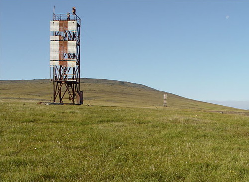
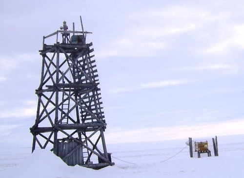
Date unknown. Active; focal plane 29 m (95 ft); white flash every 4 s. Approx. 16 m (52 ft) square cylindrical skeletal tower. The tower carries slatted daymarks painted black with a large white diamond-shaped marking. Evgeny Gusev's photo is above right and Google has a satellite view. Located on a sharp promontory on the north side of the entrance to Tiksi Bay. Site status unknown. NGA 17540.
Ostrov Brusneva
Date unknown. Active; focal plane 32 m (105 ft); white flash every 8 s. 10 m (33 ft) square pyramidal wood skeletal tower painted white with a black vertical stripe on each face. A 2015 photo is at right, Sergey Kruchin has a 2019 photo, and Google has a satellite view. Located on an island in Tiksi Bay, about 6.5 km (4 mi) northeast of the town. Accessible only by boat. Site status unknown. NGA 17560.

Mys Musotakh Light
Mys Muostakh Light, Tiksi, summer 2004
photo copyright Evgeny Gusev; used by permission


Ostrov Brusneva Light, Tiksi, June 2015
ex-Panoramio Creative Commons photo by Calvusstump

Tiksi Range Front
Date unknown. Active; focal plane 15 m (49 ft); white flash every 3 s. 10 m (33 ft) square cylindrical skeletal tower carrying a slatted daymark painted white with a red vertical stripe. Evgeny Gusev's photo of both range lights is at right and Google has a satellite view. Located near the shore of Tiksi Bay about 1.6 km (1 mi) south of the town. Site open, tower closed. NGA 17572.
Tiksi Range Rear
Date unknown. Active; focal plane 22 m (72 ft); white flash every 6 s. Approx. 14 m (46 ft) square cylindrical skeletal tower carrying a slatted daymark painted white with a red vertical stripe. Evgeny Gusev's photo of both range lights is at right, Lightphotos.net has a photo and Google has a satellite view. Located about 700 m (0.21 mi) west of the front light. Site open, tower closed. NGA 17576.
Ostrov Muostakh (2)
Date unknown (station established 1935). Active; focal plane 29 m (95 ft); white flash every 6 s. 27 m (89 ft) round cylindrical concrete tower with lantern and gallery; the tower is covered with wood siding applied in a spiral pattern. Lighthouse originally painted with red and white horizontal bands but now unpainted; lantern painted black. Thomas Opel's photo is at the top of this page, Lightphotos.net has a photo of the station, and the lighthouse appears in a 1987 photo, but Google has only a distant satellite view of the island. The original lighthouse is still described by NGA: a "square wooden framework column." Lightphotos.net has a historic photo of that tower. Ostrov Muostakh is a narrow 13 km (8 mi) long island southeast of the entrance to Tiksi Bay. Located near the southern end of the island. Accessible only by boat. Site status unknown. NGA 17552.
Tiksi Range Lights
Tiksi Range Lights, Tiksi, summer 2004
photo copyright Evgeny Gusev; used by permission
Ostrov Muostakh Yuzhnyy
Date unknown. Active; focal plane 14 m (46 ft); white flash every 3 s. 12 m (39 ft) square pyramidal wood tower. No photo available and Google has only a distant satellite view. This light is described by NGA as being on the "southern extremity" of Ostrov Muostakh, but it is actually located on an smaller island several miles to the south. Accessible only by boat. Site status unknown. Admiralty L9550; NGA 17556.
Mys Buor-Khaya
Date unknown. Active; focal plane 37 m (121 ft); white flash every 4 s. 12 m (39 ft) square pyramidal wood tower. No photo available and Google has only a distant satellite view. Located on a promontory marking the east side of the mouth of the Buro-Khaya Gulf. Site status unknown. NGA 17580.

Yana Bay Lighthouses
Yana (Yanskiy) Bay is the bight of the southeastern Laptev Sea eastward of Mys Buor-Khaya. A large part of the shoreline of the bay is occupied by the delta of the Yana River.

Yanskiy Bay (Yana Delta)
Date unknown. Active; focal plane 14 m (46 ft); white flash every 5 s. 12 m (39 ft) square pyramidal wood tower. No photo available and Google has only a distant satellite view. Located on an island in the delta of the Yana River. Site status unknown. NGA 17584.
Ostrov Makar
Date unknown. Active; focal plane 40 m (131 ft); white flash every 5 s. 8 m (26 ft) square pyramidal wood tower. No photo available and Google has only a distant satellite view. In the former Panoramio.com Pavel Boyko had a photo of ruined structures at this station, putting the survival of the lighthouse in some doubt. Located on an island in the southeastern corner of Yana Bay. Site status unknown. NGA 17588.

New Siberian Islands and Laptev Strait Lighthouses
The New Siberian Islands form a loose archipelago separating the Laptev Sea on the west from the East Siberian Sea on the east. For ships on the Northern Sea Route there are two possible passages through the islands. The Laptev Strait (or Dmitry Laptev Strait) separates the mainland from the Lyakhovsky Islands, the southernmost group of the archipelago, while the Sannikov Strait is between the Lyakhovsky Islands and the large island of Kotelny to the north.

Mys Svyatoy Nos
Date unknown. Active; focal plane 15 m (49 ft); white light, 2 s on, 6 s off. 12 m (39 ft) square pyramidal wood tower. No photo available and Google has only a distant satellite view. Located on a promontory of the mainland marking the western entrance to the Laptev Strait. Site status unknown. NGA 17608.
Mys Kigilyakh
Date unknown. Active; focal plane 32 m (105 ft); two white flashes every 8 s. 13 m (43 ft) square pyramidal wood tower. No photo available and Google has only a distant satellite view. Located on the southwestern point of Ostrov Bol'shoy Lyakhovskiy marking the north side of the western entrance to the Laptev Strait. Site status unknown. NGA 17600.
Ostrov Stolbovoy
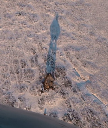
Date unknown. Active; focal plane 46 m (151 ft); white flash every 2 s. 12 m (39 ft) square pyramidal wood tower. Lightphotos.net has Roman Chudinov's aerial photo also seen at right and Google has a distant satellite view. Stolbovoy is a substantial island, 47 km (29 mi) long and 10 km (6 mi) wide, located in the Laptev Sea about 100 km (60 mi) west of the two straits. Located on the southern tip of the island. Accessible only by boat. Site status unknown. NGA 17592.
Ostrov Stolbovoy Severnyy
Date unknown. Active; focal plane 13 m (43 ft); white light, 2 s on, 4 s off. 8 m (26 ft) square pyramidal wood tower. No photo available and Google has a distant satellite view. Located on the northern tip of Ostrov Stolbovoy. Accessible only by boat. Site status unknown. NGA 17596.
Ostrov Bel'kovskiy
Date unknown. Active; focal plane 27 m (89 ft); one long white flash every 8 s. 12 m (39 ft) square pyramidal wood tower. No photo available and Google has only a distant satellite view. Located at the southwestern point of Ostrov Bel'kovskiy, an island off the west coast of Ostrov Kotelny, the largest of the New Siberian Islands. Accessible only by boat. Site status unknown. Admiralty L9575.
Sannikova
Date unknown. Active; focal plane 59 m (194 ft); white light, 2 s on, 6 s off. 18 m (59 ft) square pyramidal wood tower. No photo available and Google has only a distant satellite view. Located on the southwestern point of Ostrov Kotelny marking the north side of the Sannikov Strait. Admiralty L9600; Site status unknown. NGA 17632.
Khronomeyetr
Date unknown. Active; focal plane 44 m (144 ft); one long white flash every 15 s. 13 m (43 ft) square pyramidal wood tower. No photo available and Google has only a distant satellite view. Located on the southeastern point of Ostrov Bol'shoy Lyakhovskiy marking the north side of the eastern entrance to the Laptev Strait. Site status unknown. NGA 17624.
Ostrov Stolbovoy Light
Ostrov Stolbovoy Light, Laptev Sea, October 2010
ex-Panoramio photo copyright Roman Chudinov; used by permission

Medvezhyi Islands Lighthouses
The Medvezhyi (Bear) Islands are an archipelago of small islands at the western end of the Kolyma Gulf, about 100 km (60 mi) north of the delta of the Kolyma River. The islands are a sanctuary and breeding ground for polar bears. The lights on the islands are probably abandoned.

Ostrov Krestovskiy
Date unknown. Active (?); focal plane 73 m (240 ft); white flash every 4 s. 12 m (39 ft) square pyramidal wood tower. No photo available and Google's satellite view is too drak to show detail. Located on the northwestern point of Ostrov Krestovskiy marking the northwestern end of the islands. Accessible only by boat. Site status unknown. NGA 17640.
Ostrov Pushkareva
Date unknown. Active (?); focal plane unknown; white flash every 2 s. NGA does not provide any description of this light. No photo available but the light is probably seen in Google's very distant satellite view. Located on the northeasternmost of the Medvezhyi Islands. Accessible only by boat. Site status unknown. NGA 17644.
Ostrov Chetyrekhstolbovoy
Date unknown. Active (?); focal plane unknown; white flash every 4 s. 10 m (33 ft) square pyramidal wood tower. NGA does not provide any description of this light. No photo available and the lighthouse is not seen in Google's satellite view of the former Soviet station on the island. Located on the easternmost of the Medvezhyi Islands. Accessible only by boat. Site status unknown. NGA 17648.

Kolyma River and Ambarchik Area Lighthouses
The Kolyma River enters the Kolyma Gulf through a large delta near the eastern border of the Sakha Republic. Ambarchik is an abandoned Soviet outpost on the east side of the delta; it served as the seaport and administrative center for gulag labor camps at gold mines in the Kolyma basin.

Kabachkovskiy
Date unknown. Probably inactive; listed with focal plane and light characteristic unknown. Square pyramidal wood tower, height unknown. No photo available but Google has a satellite view. Located on heights above a sharp bend in the lower course of the Kolyma River. Site status unknown. Admiralty L9656.
Medvezhiy (Protoka Kamenna Kolyma, Ambarchik) Range Front
Date unknown. Inactive; listed with focal plane 23 m (75 ft); white flash every 2 s. 9 m (30 ft) square pyramidal wood tower carrying a slatted daymark. Lightphotos.net has a photo (seen at right) believed to show this light, Wikimapia has a very distant view of the two range lights, and Bing has an indistinct satellite view. Located on a cape on the east side of Ambarchik Bay. Site status unknown. Admiralty L9657; NGA 17652.
Medvezhiy (Protoka Kamenna Kolyma, Ambarchik) Range Rear
Date unknown. Active (?); listed with focal plane 26 m (85 ft); white flash every 3 s. 12 m (39 ft) square pyramidal wood tower carrying a slatted daymark. No photo available but Bing has an indistinct satellite view. Located 500 m (0.3 mi) south of the front light. Site status unknown. Admiralty L9657.1; NGA 17656.

Ambarchik Range Front Light, Kolyma Gulf
Polar Post photo from Lightphotos.net

Information available on lost lighthouses:

Notable faux lighthouses:

Adjoining pages: East: Northern Chukotka | West: Taymyria

Return to the Lighthouse Directory index | Ratings key

Posted January 14, 2012. Checked and revised June 6, 2024. Lighthouses: 34. Site copyright 2024 Russ Rowlett and the University of North Carolina at Chapel Hill.