Lighthouses of Russia: Yenisey Gulf

Russia (Россия, Rossiya in Russian) is by far the world's largest country, spanning a little over 150° in longitude. It is organized as the Russian Federation (Rossiyskaya Federatsiya) with members known as federal subjects (sub'yekty federatsii). Russia is primarily a continental nation but it has important coastlines on the Baltic, Black, and Caspian Seas and very long coastlines on the Arctic Ocean and North Pacific Ocean. To guard these coasts it operates hundreds of lighthouses, many of them historic.

Most of Siberia is drained by one of three great rivers: the Ob, the Yenisey, and the Lena. The Yenisey River is the largest of the three river systems. The lower course of the river is an estuary called the Yenisey Gulf; the gulf is about 250 km (155 mi) long and up to 50 km (30 mi) wide. The gulf empties into the Kara Sea, a basin of the Arctic Ocean. This page describes the numerous lighthouses along the gulf and its approaches.

Administratively this region is part of the Taymyrsky Dolgano-Nenetsky District of Krasnoyarsk Krai, the second largest of the federal subjects. The district is larger than Texas but has fewer than 35,000 permanent residents, most of whom live in the town of Dudinka on the lower Yenisey River. Dikson is the only permanent settlement on the gulf.

The Russian word for a lighthouse is mayak (маяк); ostrov is an island, poluostrov is a peninsula, mys is a cape, bukhta or guba is a bay, zaliv is a larger bay or gulf, proliv is a strait, reka is a river, and gavan' is a harbor.

Russian lighthouses are owned by the Russian Navy and maintained by the Navy's Office of Navigation and Oceanography (Управление навигации и океанографии).

Special thanks to V.I. Radygin and Evgeny Gusev for permission to present their photos on thos page.

ARLHS numbers are from the ARLHS World List of Lights. Russian light list (RU) numbers are from Russian Navy Publication 2111 (Kara Sea) as reported by the Admiralty. After 2014 both the Admiralty and NGA dropped their listings of the Yenisey Gulf lights south of the Dikson area. The former Admiralty numbers are from volume L of the Admiralty List of Lights & Fog Signals. Former U.S. NGA numbers are from Publication 115.

General Sources
World of Lighthouses - Russia Arctic Ocean
Photos available from Lightphotos.net.
Online List of Lights - Russia - Arctic Sea Coast
Photos by various photographers posted by Alexander Trabas.
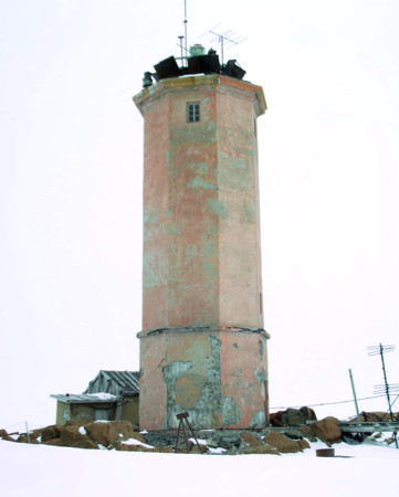
Bol'shoy Medvezhiy Light
Bol'shoy Medvezhiy Light, Dikson, May 2004
photo copyright V.I. Radygin; used by permission
Nosok and Sibiryakova Islands Lighthouses
Ostrov Nosok
Date unknown. Active; focal plane 19 m (62 ft); white flash every 7 s. 17 m (56 ft) square pyramidal tower, painted black. No photo available and Google has only a blurred satellite view of the area. Located on Ostrov Nosok, an island off the mouth of the Yenisey. Accessible only by boat. Site status unknown. RU 2111-1500; Admiralty L8203; NGA 17008.
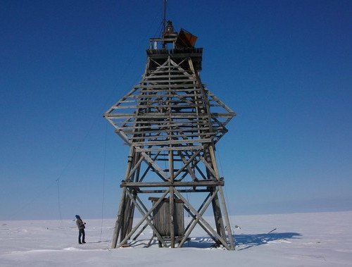
Ostrov Sibiryakova Severo-Vostochnyy (Sibiryakova Northeast)
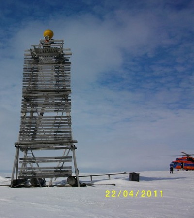
Date unknown. Active; focal plane 17 m (56 ft); white flash every 4 s. Approx. 15 m (49 ft) square pyramidal wood skeletal tower, carrying a diamond-shaped slatted daymark. A photo is at right but Google has only a blurred satellite view of the area. Located on the northeast side of Ostrov Sibiryakova, a large island south of Ostrov Nosok in the mouth of the Yenisey. Accessible only by boat. Site status unknown. RU 2111-1540; Admiralty L8209; NGA 17132.
Mys Krutova (Sibiryakova Southeast)
Date unknown. Active; focal plane 31 m (102 ft); white flash every 9 s. 27 m (89 ft) square pyramidal tower, painted red. No photo available and Google has only a blurred satellite view of the area. Located on the southeastern tip of Sibiryakova island. Site status unknown. RU 2111-1555; Admiralty L8208; NGA 17136.
Ostrov Sibiryakov Yuzhnyy (Sibiryakova South)
Date unknown. Active; focal plane 15 m (49 ft); two white flashes every 10 s. 12 m (39 ft) square pyramidal tower. No photo available and Google has only a distant satellite view of the area. Located on the central south coast of Sibiryakova. Site status unknown. RU 2111-1520; Admiralty L8206; NGA 17120.
Ostrov Sibiryakov Zapadnyy (Sibiryakova West)
Date unknown. Active; focal plane 15 m (49 ft); two white flashes every 10 s. 8 m (26 ft) square pyramidal tower. No photo available and Google has only a distant satellite view of the area. Located on the western tip of Sibiryakova. Site status unknown. RU 2111-1530; Admiralty L8204; NGA 17128.
Sibiyakova Northeast Light
Ostrov Sibiryakova Northeast Light, April 2011
ex-Panoramio photo copyright V.I. Radygin; used by permission
Yenisey Gulf West Side Lighthouses
Mys Leskina (Leskino, Leskin)
Date unknown. Active; focal plane 89 m (292 ft); two white flashes every 10 s. 15 m (49 ft) square pyramidal wood tower, painted black with a white vertical stripe. No photo available but a faint spot in the center of Google's satellite view is probably the lighthouse. Located on high bluff on the west side of the gulf, about 100 km (60 mi) south of Sibiryakova island. Accessible only by boat. Site status unknown. RU 2111-1663; Admiralty L8210; NGA 17168.
Mys Peschanyy
Date unknown. Active; focal plane 21 m (69 ft); white flash every 2 s. Approx. 20 m (66 ft) square pyramidal steel skeletal tower with gallery, painted red. No photo available and Google has only a very distant satellite view of the area. Located on a sandy spit off a prominent cape of the west side of the gulf south of the Korsakov islands. Accessible only by boat. Site status unknown. RU 2111-1675; Admiralty L8217; NGA 17176.
Narzoy
Date unknown. Active; focal plane 54 m (177 ft); two white flashes every 10 s. 16 m (52 ft) square pyramidal wood tower, painted black with two trapezoidal daymarks. No photo available and Google has only a very distant satellite view of the area. Located at the southern entrance to the narrower section of the gulf. Site status unknown. RU 2111-2005; ex-Admiralty L8222; ex-NGA 17224.
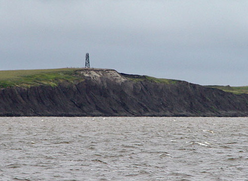
Oshmarino Verkhiy
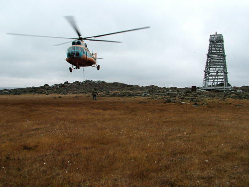
Date unknown. Active; focal plane 72 m (236 ft); two white flashes every 5 s. 18 m (56 ft) square pyramidal wood tower, painted black, with what NGA calls a "lantern platform." Evgeny Gusev's view from the gulf is at right and Google has an indistinct satellite view that probably locates the lighthouse. Located on the south side of the gulf near a sharp turn southward. Site status unknown. RU 2111-2105; ex-Admiralty L8227; ex-NGA 17232.
Mys Zverevskiy
Date unknown. Active; focal plane and light characteristic unknown. Square pyramidal skeletal tower, height unknown. No photo available but Google has a satellite view. Located on a prominent headland opposite Vorontsovo, south of the sharp turn in the estuary. Site status unknown. RU 2111-2035; ex-Admiralty L8230.
Innokent'yevskiy Range Rear
Date unknown. Active; focal plane 62 m (259 ft); one long red flash every 6 s. 16 m (52 ft) square pyramidal skeletal tower carring a slatted daymark painted white with a black vertical stripe. No photo available but Google has a good satellite view. This range guides northbound vessels. Located north of Innokent'yevsk. Site status unknown. RU 2111-2051; ex-Admiralty L8238.1.
Innokent'yevskiy Range Front
Date unknown. Active; focal plane 62 m (203 ft); red flash every 1.5 s. 12 m (39 ft) square pyramidal skeletal tower carring a slatted daymark painted white with a black vertical stripe. No photo available but Google has a good satellite view. Located about 800 m (1/2 mi) south of the rear light. Site status unknown. RU 2111-2050; ex-Admiralty L8238.

Oshmarino Verkhiy Light, summer 2005
photo copyright Evgeny Gusev; used by permission

Yenisey Gulf Upper East Side Lighthouses
Sekstan
Date unknown. Active; focal plane 68 m (223 ft); white flash every 3 s. 10 m (33 ft) square pyramidal skeletal tower. No photo available and Google has only a distant satellite view of the area. Located at the extreme upper end of the gulf, this light guides vessels entering the Yenisey River delta. Located south of Yakovlevka. Site status unknown. RU 2111-2120; ex-Admiralty L8246.4.
Yakovlevskaya Kosa
Date unknown. Active; focal plane 23 m (75 ft); two white flashes every 5 s. 18 m (56 ft) square pyramidal skeletal tower. No photo available and Google has only a distant satellite view of the area. Located in a river delta north of Yakovlevka. Site status unknown. RU 2111-2115; ex-Admiralty L8246.
Gostinyy
Date unknown. Active; focal plane 48 m (157 ft); two white flashes every 10 s. 6 m (?) square pyramidal skeletal tower. No photo available but Google has a satellite view. The satellite image suggests a tower much taller than 6 m (20 ft). Located on a promontory about 30 km (20 mi) north of the Yenisey River delta. Site status unknown. RU 2111-2085; ex-Admiralty L8245.
Orlovka
Date unknown. Active; focal plane 85 m (279 ft); white flash every 5 s. 15 m (49 ft) square pyramidal skeletal tower. No photo available but Google has a satellite view. Located on a high bluff about 20 km (13 mi) northeast of the Gostinyy light. Site status unknown. RU 2111-2074; ex-Admiralty L8244.6.
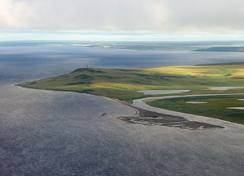
Mezenina
Date unknown. Active; focal plane 75 m (246 ft); red flash every 5 s. 8 m (26 ft) square pyramidal skeletal tower. The lighthouse can be seen on the hill left of center in Evgeny Gusev's aerial photo at right and Google has a good satellite view. Located on a high bluff at an important bend in the gulf. Site status unknown. RU 2111-2060; ex-Admiralty L8242.
Kazachiy Ruchey Range Rear
Date unknown. Active; focal plane 85 m (279 ft); one long white flash every 6 s. 21 m (69 ft) skeletal tower, painted black. No photo available but Google has a satellite view. This is a southbound range marking the channel through the strait between Mys Zverevskiy and Gol'chikha. Its name means "Cossack Creek," and it is located on the north side of the creek. Site status unknown. RU 2111-2042; ex-Admiralty L8235.51.
Kazachiy Ruchey Range Front
Date unknown. Active; focal plane 61 m (200 ft); white flash every 1.5 s. 18 m (59 ft) skeletal tower, painted white. No photo available but Google has a satellite view. Located northwest of the front light. Site status unknown. RU 2111-2041; ex-Admiralty L8235.5.
Gol'chikha Range Front
Date unknown. Active; focal plane 55 m (180 ft); white flash every 1.5 s. 12 m (39 ft) square pyramidal steel skeletal tower carring a slatted daymark painted white with a black vertical stripe. No photo available but Google has a distant satellite view. This range guides northbound vessels in a narrow passage of the gulf. Located on heights east of the gulf south of the Troitsk settlement, on the south side of the Gol'chikha River. Site status unknown. ex-Admiralty L8235; ex-NGA 17244.

Mezenina Light, summer 2005
photo copyright Evgeny Gusev; used by permission
Gol'chikha Range Rear
Date unknown. Active; focal plane 75 m (246 ft); white light, 2 s on, 4 s off. 15 m (49 ft) square pyramidal steel skeletal tower carring a slatted daymark painted white with a black vertical stripe. No photo available but Google has a good satellite view. Located 200 m (220 yd) northeast of the front light. Site status unknown. ex-Admiralty L8235.1; ex-NGA 17248.
Troitsky Pesok Range Front
Date unknown. Active; focal plane 57 m (187 ft); white flash every 1.5 s. 18 m (59 ft) square pyramidal steel skeletal tower carring a slatted daymark painted white with a black vertical stripe. No photo available but Google has a good satellite view. This range guides southbound vessels in the narrow west-to-east section of the gulf. Located on heights east of the gulf north of the Troitsk settlement. Site status unknown. RU 2111-2021; ex-Admiralty L8229; ex-NGA 17236.
Troitsky Pesok Range Rear
Date unknown. Active (?); focal plane 78 m (256 ft); white light, 2 s on, 4 s off. 24 m (79 ft) square pyramidal steel skeletal tower carring a slatted daymark painted white with a black vertical stripe. No photo available. Google's satellite view is ambiguous; it appears that the tower may have fallen. Located 400 m (1/4 mi) east southeast of the front light. Site status unknown. RU 2111-2022; ex-Admiralty L8229.1; ex-NGA 17240.

Yenisey Gulf Lower East Side Lighthouses
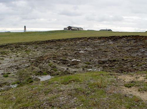
Mys Sapochnaya Karga (Sop-Karga)
Date unknown. Active; focal plane 49 m (161 ft); white flash every 5 s. 19 m (62 ft) square pyramidal tower with a rectangular black daymark. Evgeny Gusev's distant view is at right but Google has only a very distant satellite view of the cape. For southbound vessels this light marks the beginning of a much narrower section of the waterway as well as a sharp turn to the east. It appears that the lighthouse may become endangered by rapid erosion of the point. NGA continues to list a racon at this light. Located on a very prominent cape on the east side of the gulf. Site status unknown. RU 2111-1840; ex-Admiralty L8221; NGA 17204.

Mys Sapochnaya Karga Light, summer 2005
photo copyright Evgeny Gusev; used by permission
Mironovskiy Range Front
Date unknown. Active; focal plane 44 m (144 ft); white flash every 3 s. 18 m (59 ft) skeletal tower carrying a daymark painted black with a white vertical stripe. No photo available and Google has only a fuzzy satellite view of the area. This is a southbound range guiding vessels approaching the Sop-Karga cape. Located about 8 km (5 mi) north of Mys Sapochnaya Karga. Site status unknown. RU 2111-2026; ex-Admiralty L8221.4.
Mironovskiy Range Rear
Date unknown. Active; focal plane 54 m (177 ft); one long white flash every 6 s. 13 m (43 ft) skeletal tower carrying a daymark painted black with a white vertical stripe. No photo available and Google has only a fuzzy satellite view of the area. This is a southbound range guiding vessels approaching the Sop-Karga cape. Located 555 m (1/3 mi) east southeast of the front light. Site status unknown. ex-Admiralty L8221.41.
Ksen'yevskiy Yuzhnyy (Northbound Range Middle)
Date unknown. Active; focal plane 43 m (141 ft); red flash every 3 s. 15 m (49 ft) square pyramidal skeletal tower carrying a slatted daymark painted black with a white vertical stripe. Evgeny Gusev's photo is at right but Google has only a very distant satellite view of the area. The front beacon of this range is unlit. Located about 10 km (6 mi) southeast of Mys Shaytanskiy. Site status unknown. ex-Admiralty L8220.1; ex-NGA 17196.
Ksen'yevskiy Range Common Rear
Date unknown. Active; focal plane 55 m (180 ft); white light (for the southbound range) or red light (for the northbound range), 2 s on, 4 s off. 15 m (49 ft) square pyramidal skeletal tower carrying a slatted daymark painted black with a white vertical stripe. The lighthouse is seen in the lower rear of Gusev's photo (at right) of the southbound front light but Google has only a very distant satellite view of the location. NGA continues to list a racon at this light. Located 366 m (400 yd) southeast of the southbound front light. Site status unknown. RU 2111-1811; ex-Admiralty L8220; NGA 17192.
Ksen'yevskiy Range Lights
Ksen'yevskiy Yuzhnyy Range Lights, summer 2005
photo copyright Evgeny Gusev; used by permission
Ksen'yevskiy Severo-Zapadnyy (Southbound Range Front)
Date unknown. Active; focal plane 55 m (180 ft); white flash every 3 s. 15 m (49 ft) square pyramidal skeletal tower carrying a slatted daymark painted black with a white vertical stripe. No photo available and Google has only a very distant satellite view of the location. Located about 10 km (6 mi) southeast of Mys Shaytanskiy. Site status unknown. RU 2111-1810; ex-Admiralty L8219.9; ex-NGA 17188.
Reka Sarikha (Sariha) Range Front
Date unknown. Active; focal plane 37 m (121 ft); yellow light, 0.75 s on, 0.75 s off. 12 m (39 ft) square pyramidal skeletal tower carrying a slatted daymark painted black with a white vertical stripe. A closeup photo is at right but Google has only a very distant satellite view of the location. Located about 8 km (5 mi) southeast of Mys Shaytanskiy (next entry). Site status unknown. RU 2111-1820; Admiralty L8219; NGA 17216.
Reka Sarikha (Sariha) Range Rear
Date unknown. Active; focal plane 52 m (171 ft); yellow light, 3 s on, 3 s off. 15 m (49 ft) square pyramidal skeletal tower carrying a slatted daymark painted black with a white vertical stripe. The lighthouse is seen in the rear of the photo (at right) of the front light but Google has only a very distant satellite view of the location. Located about 8 km (5 mi) southeast of Mys Shaytanskiy (next entry). Site status unknown. RU 2111-1821; Admiralty L8219.1; NGA 17220.
Mys Shaytanskiy
Date unknown. Active; focal plane 105 m (344 ft); white flash every 9 s. 15 m (49 ft) square pyramidal wood tower, painted black. Gusev has a photo but Google has only a very distant satellite view of the cape. Located on a very prominent cape on the east side of the gulf. Site status unknown. RU 2111-1800; Admiralty L8218; NGA 17184.
Kamenka
Date unknown. Active; focal plane 86 m (282 ft); white flash every 5 s. 15 m (49 ft) square pyramidal wood tower, painted black. No photo available and Google has only a very distant satellite view of the area. Located on high bluff on the east side of the gulf, about 50 km (30 mi) east of the Korskov islands. Site status unknown. RU 2111-1792; Admiralty L8217.4; NGA 17180.
Sariha Range Front Light
Sariha Range Front Light, April 2011
photo copyright V.I. Radygin; used by permission
Ostrov Malyy Korsakovskiy
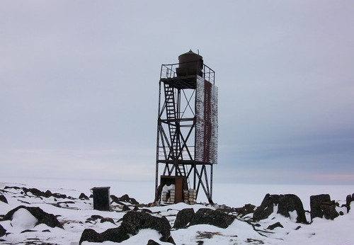
Date unknown. Active; focal plane 33 m (108 ft); white flash every 4 s. 14 m (46 ft) square pyramidal steel skeletal tower with gallery, painted red. V.I. Radygin's photo is at right but Google has only a very distant satellite view of the island. Located on a small island in the middle of the gulf. Accessible only by boat. Site status unknown. RU 2111-1780; Admiralty L8215; NGA 17164.
Bol'shoy Korsakovskiy Range Front
Date unknown. Active; focal plane 20 m (66 ft); white light, 1 s on, 1 s off. 15 m (49 ft) square pyramidal skeletal tower carrying a slatted daymark painted black with a white vertical stripe. No photo available and Google has only a very distant satellite view of the location. This range guides northbound vessels. Located at the southeastern end of Ostrov Korsakovskiy. Accessible only by boat. Site status unknown. Admiralty RU 2111-1751; L8214.5; NGA 17162.
Bol'shoy Korsakovskiy Range Rear
Date unknown. Active; focal plane 24 m (79 ft); white light, 2 s on, 2 s off. 18 m (59 ft) square pyramidal skeletal tower carrying a slatted daymark painted white with a black vertical stripe. No photo available and Google has only a very distant satellite view of the location. Located near the northwestern end of Ostrov Korsakovskiy, about 3 km (2 mi) northwest of the front light. Accessible only by boat. Site status unknown. RU 2111-1752; Admiralty L8214.51; NGA 17162.5.
Ostrov Chayashnyy
Date unknown. Active; focal plane 23 m (75 ft); white flash every 4 s. 16 m (52 ft) square pyramidal skeletal tower. No photo available and the island is only a blur in Google's satellite view of the location. Located on a small island about 3 km (2 mi) northeast of Korsakov island. Accessible only by boat. Site status unknown. RU 2111-1760; Admiralty L8214; NGA 17160.
Malyy Korsakovskiy Light
Ostrov Malyy Korsakovskiy Light, April 2011
photo copyright V.I. Radygin; used by permission
Ostrov Krestovskiy Yuzhnyy
Date unknown. Active; focal plane 21 m (69 ft); white light, 2 s on, 6 s off. 12 m (39 ft) square pyramidal skeletal tower. No photo available and Google has only a very distant satellite view of the location. Located at the southern tip of Ostrov Krestovskiy, an island off the east coast of the gulf about 65 km (40 mi) southeast of Sibiryakova island. Accessible only by boat. Site status unknown. RU 2111-1720; Admiralty L8212; NGA 17152.
Moska Range Front
Date unknown. Active; focal plane 20 m (66 ft); white flash every 2 s. 13 m (43 ft) square pyramidal skeletal tower carrying a slatted daymark painted white with a black vertical stripe. No photo available and Google has only a very distant satellite view of the location. This range guides northbound vessels. Located near the south end of Ostrov Krestovskiy. Accessible only by boat. Site status unknown. RU 2111-1710; Admiralty L8211; NGA 17144.
Moska Range Rear
Date unknown. Active; focal plane 38 m (125 ft); white light, 2 s on, 4 s off. 13 m (43 ft) square pyramidal skeletal tower carrying a slatted daymark painted white with a black vertical stripe. No photo available and Google has only a very distant satellite view of the location. Located near the north end of Ostrov Krestovskiy, nearly 4 km (2.5 mi) northeast of the front light. Accessible only by boat. Site status unknown. RU 2111-1711; Admiralty L8211.1; NGA 17148.
Bukhta Shirokaya Range Front
Date unknown. Active; focal plane 15 m (49 ft); white light, 1 s on, 1 s off. 13 m (43 ft) square pyramidal skeletal tower carrying a slatted daymark painted black with a white vertical stripe. No photo available and Google has only a very distant satellite view of the location. This range also guides northbound vessels. Located on a promontory of the mainland opposite Ostrov Krestovskiy. Site status unknown. RU 2111-1741; Admiralty L8213; NGA 17156.
Bukhta Shirokaya Range Rear
Date unknown. Active; focal plane 25 m (82 ft); white light, 2 s on, 2 s off. 15 m (49 ft) square pyramidal skeletal tower carrying a slatted daymark painted black with a white vertical stripe. V.I. Radygin's photo is at right but Google has only a very distant satellite view of the location. Located about 1.4 km (0.9 mi) northwest of the front light. Accessible only by boat. Site status unknown. RU 2111-1742; Admiralty L8213.1; NGA 17156.1.
Mys Kuznetsovskiy
Date unknown. Active; focal plane 46 m (151 ft); white light, 2 s on, 6 s off. 18 m (59 ft) square pyramidal skeletal tower, painted black. No photo available and Google has only a very distant satellite view of the location. Located on a promontory on the east side of the gulf opposite Sibiryakova island. Site status unknown. RU 2111-1630; Admiralty L9278; NGA 17116.
Mys Brazhnikova
Date unknown. Active; focal plane 48 m (157 ft); white light, 2 s on, 4 s off. 16 m (52 ft) square pyramidal skeletal tower, painted black. No photo available and Google has only a very distant satellite view of the location. Located on a prominent cape about 50 km (30 mi) south of Dikson. Site status unknown. RU 2111-1600; Admiralty L9286; NGA 17104.
Bukhta Shirokaya Range Front Light
Bukhta Shirokaya Range Rear Light, April 2011
photo copyright V.I. Radygin; used by permission
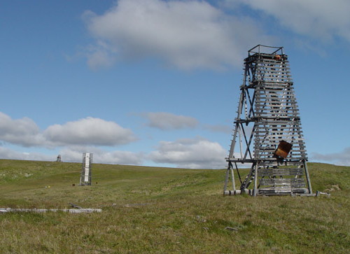
Mys Yefremov Kamen'
Date unknown. Active; focal plane 67 m (220 ft); white flash every 3 s. 12 m (39 ft) square pyramidal skeletal tower, painted in a black and white checkered pattern. No photo available and Google has only a very distant satellite view of the location. Located on a prominent cape about 40 km (25 mi) south of Dikson. Site status unknown. RU 2111-1590; Admiralty L9288; NGA 17100.
Mys Isachenko
Date unknown. Active; focal plane 49 m (161 ft); white flash every 5 s. 14 m (46 ft) square pyramidal tower, painted with black and white horizontal bands. No photo available and Google has only a very distant satellite view of the location. Located on a sharp promontory about 30 km (19 mi) south of Dikson. Site status unknown. RU 2111-1580; Admiralty L9290; NGA 17096.

Dikson Area Lighthouses

Founded in 1915 and located on the east side of the entrance to the Yenisey, the settlement of Dikson is named for Oscar Dickson, a Swedish industrialist who financed the exploration of the Arctic coastlines during the late nineteenth century. Calling itself the "Capital of the Arctic," Dikson is the northernmost town on the Eurasian continent. Late in the Soviet era Dikson had about 4500 residents, but the 2010 census counted only 676. Dikson is Russia's northernmost port and probably Eurasia's northernmost town at latitude 73° 30.4' N.

Ostrov Bol'shoy Korablik
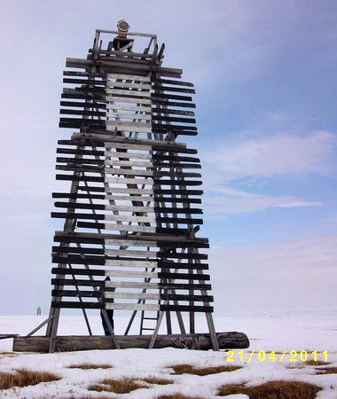
Date unknown. Active; focal plane 28 m (92 ft); red flash every 4 s. 14 m (46 ft) square pyramidal tower painted with black and white horizontal bands. V.I. Radygin's photo is at right and Google has a satellite view. Located on an island about 15 km (9 mi) south of Dikson. Site status unknown. RU 2111-3020; Admiralty L9309.

Ostrov Bol'shoy Korablik Light, April 2011
photo copyright V.I. Radygin; used by permission
Ostrov Malyy Oleniy Range Front
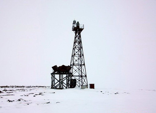
Date unknown. Active; focal plane 24 m (79 ft); yellow light, 1 s on, 1 s off. Approx. 12 m (39 ft) square cylindrical skeletal tower with lantern, carrying a slatted daymark painted white with a black vertical stripe. V.I. Radygin's photo is at right and Google has a distant satellite view. This is an approach range for Dikson for vessels rounding the south side of Ostrov Dikson. Located on a small island about 10 km (6 mi) south of Dikson. Accessible only by boat. Site status unknown. RU 2111-3070; Admiralty L9300; NGA 17024.
Ostrov Malyy Oleniy Range Rear
Date unknown. Active; focal plane 37 m (121 ft); yellow light, 2 s on, 2 s off. 17 m (56 ft) square cylindrical skeletal tower with lantern, carrying a slatted daymark painted white with a black vertical stripe. No photo available but Google has a distant satellite view. Located on the same island as the front light, 740 m (0.46 mi) east southeast. Accessible only by boat. Site status unknown. RU 2111-3071; Admiralty L9300.1; NGA 17028.
Poluostrov Skuratova Range Front
Date unknown. Active; focal plane 29 m (95 ft); red flash every 1.5 s. 15 m (49 ft) square cylindrical skeletal tower with lantern, carrying a slatted daymark painted white with a black vertical stripe. No photo available but Google has a distant satellite view. This is a second approach range for vessels arriving in Dikson. Located near the end of the Skuratova Peninsula, about 5 km (3 mi) south of Dikson. Site status unknown. RU 2111-3080; Admiralty L9308; NGA 17040.
Poluostrov Skuratova Range Rear
Date unknown. Active; focal plane 45 m (148 ft); one long red flash every 6 s. 12 m (39 ft) square cylindrical skeletal tower with lantern carrying a slatted daymark painted white with a black vertical stripe. No photo available but Google has a distant satellite view. Located 130 m (425 ft) east of the front light. Site status unknown. RU 2111-3081; Admiralty L9308.1; NGA 17044.
Ostrov Malyy Oleniy Range Front Light
Ostrov Malyy Oleniy Range Front Light, April 2011
photo copyright V.I. Radygin; used by permission
Vega (Ostrov Sakhalin) Range Front
Date unknown. Active; focal plane 22 m (72 ft); red flash every 1.5 s. 9 m (30 ft) square cylindrical skeletal tower, carrying a slatted daymark painted white with a red vertical stripe. No photo available but Google has an indistinct satellite view. This is a final approach range for Dikson for vessels coming from the south. Located on the south side of Ostrov Sakhalin, an island sheltering Dikson harbor. Accessible only by boat. Site status unknown. RU 2111-3090; ex-Admiralty L9312; NGA 17052.
Vega (Ostrov Sakhalin) Range Rear
Date unknown. Active; focal plane 28 m (92 ft); one long red flash every 6 s. 8 m (26 ft) square cylindrical skeletal tower, carrying a slatted daymark painted white with a red vertical stripe. No photo available but Google has an indistinct satellite view. Located 270 m (890 ft) north of the front light. Accessible only by boat. Site status unknown. RU 2111-3091; Admiralty L9312.1; NGA 17056.
Mys Severo-Vostochnyy (Northeast Cape) Range Front
Date unknown. Active; focal plane 17 m (56 ft); red flash every 1.5 s. 15 m (49 ft) square cylindrical skeletal tower with lantern, carrying a slatted daymark painted white with a red vertical stripe. No photo available but Google has a satellite view. This is an approach range for Dikson for vessels rounding the north side of Ostrov Dikson. Located on a very sharp gravel point on the north side of Dikson. Site status unknown. RU 2111-3140; Admiralty L9323; NGA 17084.
Mys Severo-Vostochnyy (Northeast Cape) Range Middle
Date unknown. Inactive? Approx. 13 m (43 ft) square cylindrical skeletal tower. No photo available but Google has a satellite view. This tower is between the front and rear lights and precisely on the range line, but neither the Admiralty nor NGA list a middle light. Located about 500 m (0.3 mi) east southeast of the front light. Site status unknown.
Mys Severo-Vostochnyy (Northeast Cape) Range Rear
Date unknown. Active; focal plane 45 m (148 ft); one long red flash every 6 s. 13 m (43 ft) square cylindrical skeletal tower with lantern, carrying a slatted daymark painted white with a red vertical stripe. No photo available but Google has a satellite view. Located about 800 m (0.5 mi) east southeast of the front light. Site status unknown. RU 2111-3141; Admiralty L9323.1; NGA 17088.

Ostrov Dikson Area Lighthouses

Ostrov Dikson is an island sheltering Dikson's harbor; the town's airport is located on the island.

Ostrov Verna (Vern)
Date unknown. Active; focal plane 59 m (194 ft); red flash every 5 s. 17 m (56 ft) "black wooden pyramid with a white band." Lightphotos.net has a photo by Vasily Matveev and Google has a satellite view. Located on an island about 5 km (3 mi) southwest of Ostrov Dikson. Accessible only by boat. Site status unknown. RU 2111-3050; Admiralty L9294; NGA 17012.
Ostrov Bol'shoy Medvezhiy
1942. Active; focal plane 37 m (121 ft); white light, 4 s on, 8 s off. 17 m (56 ft) octagonal cylindrical concrete tower. The lighthouse is supposed to be painted red, although nearly all the paint had worn off in the 2004 photo at the top of this page. Google has an indistinct satellite view of the station. The lighthouse was built as a memorial to the loss of the icebreaker A. Sibiryakov, sun by the German heavy cruiser Admiral Scheer in August 1942. Located on an island about 4 km (2.5 mi) west of Ostrov Dikson. Accessible only by boat. Site status unknown. RU 2111-3110; Admiralty L9327; NGA 17068.
Ostrov Dikson (2?)
Date unknown. Active; focal plane 40 m (131 ft); white flash every 7 s. 8 m (26 ft) pyramidal wood tower. No photo available but Google has a satellite view. Located at the northwestern corner of the island. Site status unknown. RU 2111-3120; Admiralty L9328; NGA 17072.
Aleyeva (Aleeva)
Date unknown. Active; focal plane 25 m (82 ft); flash every 1.5 s, white or red depending on direction. 8 m (26 ft) square pyramidal skeletal tower, carrying a slatted daymark painted black with a red vertical stripe. No photo available but Google has a satellite view. Located on the north coast of Ostrov Dikson, just north of the Port Dikson airport. Accessible only by boat. Site status unknown. RU 2111-3130; Admiralty L9324; NGA 17076.
Ostrov Matveyeva
Date unknown. Active; focal plane 17 m (56 ft); flash every 6 s. 13 m (43 ft) square pyramidal skeletal tower. No photo available but Google has a satellite view. Located on an island about 4 km (2.5 mi) northeast of Ostrov Dikson. Accessible only by boat. Site status unknown. RU 2111-3152; Admiralty L9329; NGA 17074.
Ostrova Severo-Vostochnyy (Northeast Islands)
Date unknown. Active; focal plane 16 m (52 ft); white light, 2 s on, 8 s off. 12 m (39 ft) square pyramidal skeletal tower, painted black. No photo available but Google has a satellite view. Located on an island in the northern entrance to Dikson Bay, about 8 km (5 mi) northeast of Ostrov Dikson. Accessible only by boat. Site status unknown. RU 2111-3160; Admiralty L9330; NGA 17092.

Information available on lost lighthouses:

Notable faux lighthouses:

Adjoining pages: East: Taymyria | South: Yenisey River | West: Yamalo-Nenetsia

Return to the Lighthouse Directory index | Ratings key

Posted December 5, 2011. Checked and revised May 8, 2024. Lighthouses: 62. Site copyright 2022 Russ Rowlett and the University of North Carolina at Chapel Hill.