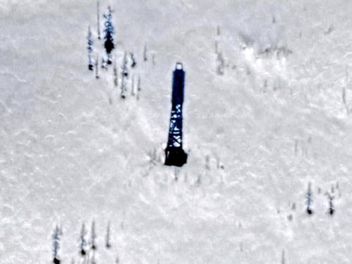
Lighthouses of Russia: Yenisey River

Russia (Россия, Rossiya in Russian) is by far the world's largest country, spanning a little over 150° in longitude. It is organized as the Russian Federation (Rossiyskaya Federatsiya) with members known as federal subjects (sub'yekty federatsii). Russia is primarily a continental nation but it has important coastlines on the Baltic, Black, and Caspian Seas and very long coastlines on the Arctic Ocean and North Pacific Ocean. To guard these coasts it operates hundreds of lighthouses, many of them historic.

Most of Siberia is drained by one of three great rivers: the Ob, the Yenisey (or Yenisei), and the Lena. The Yenisey River is the largest of Siberia's three river systems. The lower course of the river is an estuary called the Yenisey Gulf; the gulf is about 250 km (155 mi) long and up to 50 km (30 mi) wide. Upstream from the Gulf the river is navigable from June through October at least as far as the timber-exporting port of Igarka, about 675 km (420 mi) from the river's mouth. Dudinka is the only town of any size downstream from Igarka.

Administratively this region is part of the Taymyrsky Dolgano-Nenetsky District of Krasnoyarsk Krai, the second largest of the federal subjects. The district is larger than Texas but has fewer than 35,000 permanent residents, most of whom live in Dudinka.

Navigation on the river is guided by a large number of range lights. In general these lights are carried on wood skeletal towers. Some of these towers are very light in design, probably so that they can be relocated as required by changes in the river channel. This page generally lists only the larger lights, those roughly 15 m (49 ft) or taller; these are more substantial and permanent structures.

Many thanks are due to the late Michel Forand for his research on the lighthouses of the Russian Arctic; all of the information on this page comes from his work. Thanks also to Evgeny Gusev, a geologist in the All-Russia Scientific Research Institute for Geology and Mineral Resources of the Ocean, for permission to present his photos taken during geological expeditions to the lower Yenisey River in 2004 and 2005.

The Russian word for a lighthouse is mayak (маяк); ostrov is an island, poluostrov is a peninsula, mys is a cape, bukhta or guba is a bay, zaliv is a larger bay or gulf, proliv is a strait, reka is a river, and gavan' is a harbor.

Russian lighthouses are owned by the Russian Navy and maintained by the Navy's Office of Navigation and Oceanography (Управление навигации и океанографии).

Russian light list (RU) numbers are from Russian Navy Publication 2111 as reported by the Admiralty. The Admiralty is no longer listing the lights of this inland Russian waterway, but the former Admiralty numbers are from volume L of the Admiralty List of Lights & Fog Signals. None of these lights appear on the ARLHS or NGA light lists.
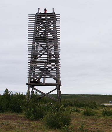

Novoselenskiy Range Rear Light, August 2009
photo copyright Evgeny Gusev; used by permission

General Sources
World of Lighthouses - Russia Arctic Ocean
Photos available from Lightphotos.net; these include several of Gusev's photos.

Yenisey Delta Lighthouses
Siderovskiy Range Rear
Date unknown. Active; focal plane 62 m (203 ft); one long white flash every 6 s. 23 m (75 ft) skeletal tower carrying a slatted daymark painted black with a white vertical stripe. No photo available and Google has only a distant satellite view of the area. This is a downstream range. Located on the east side of the river about 25 km (15 mi) south of the river's mouth. Site status unknown. RU 2111-2171; ex-Admiralty L8256.1.
Siderovskiy Range Front
Date unknown. Active; focal plane 40 m (131 ft); white flash every 1.5 s. 15 m (49 ft) skeletal tower carrying a slatted daymark painted black with a white vertical stripe. No photo available and Google has only a distant satellite view of the area. Located about 1.6 km (1 mi) south of the rear light. Site status unknown. RU 2111-2170; ex-Admiralty L8256.
Nikandrovskiy Range Front
Date unknown. Active; focal plane 48 m (157 ft); white flash every 1.5 s. 16 m (52 ft) skeletal tower carrying a slatted daymark painted white with a black vertical stripe. A photo by Roman Shul'ts is at right but Google has only a distant satellite view of the area. This is an upstream range. Located on the east side of the river just north of the settlement of Baykalovsk. Site status unknown. RU 2111-2165; ex-Admiralty L8254.
Nikandrovskiy Range Rear
Date unknown. Active; focal plane 56 m (184 ft); one long white flash every 6 s. 26 m (89 ft) skeletal tower carrying a slatted daymark painted white with a black vertical stripe. No photo available and Google has only a distant satellite view of the area. Located 930 m (0.58 mi) south of the front light. Site status unknown. RU 2111-2166; ex-Admiralty L8254.1.

Nikandrovskiy Range Front Light, August 2017
ex-Google Plus photo by Roman Shul'ts
Nikandrik Range Rear
Date unknown. Active; focal plane 21 m (69 ft); one long white flash every 6 s. 15 m (49 ft) skeletal tower carrying a slatted daymark painted white with a black vertical stripe. No photo available and Google has only a distant satellite view of the area. This is a downstream range. Located on the west side of the river opposite the Nikandrovskiy Range. Site status unknown. RU 2111-2191; ex-Admiralty L8258.1.
Nikandrik Range Front
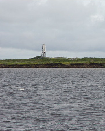
Date unknown. Active; focal plane 16 m (52 ft); white flash every 1.5 s. 12 m (39 ft) skeletal tower carrying a slatted daymark painted black with a white vertical stripe. Evgeny Gusev's photo is at right but Google has only a distant satellite view of the area. Located about 460 m (0.29 mi) south of the rear light. Site status unknown. RU 2111-2190; ex-Admiralty L8258.
Turushin-Beregovoy Range Rear
Date unknown. Active; focal plane 69 m (226 ft); one long white flash every 6 s. 15 m (49 ft) skeletal tower carrying a slatted daymark painted white with a black vertical stripe. No photo available and Google has only a distant satellite view of the area. This is a downstream range; it guides vessels in a passage diagonally across the braided river. Located on the east side of the river about 5 km (3 mi) south of Baykalovsk. Site status unknown. RU 2111-2226; ex-Admiralty L8264.1.
Turushin-Beregovoy Range Front
Date unknown. Active; focal plane 46 m (151 ft); white flash every 1.5 s. 15 m (49 ft) skeletal tower carrying a slatted daymark painted black with a white vertical stripe. No photo available and Google has only a distant satellite view of the area. Located about 1220 m (0.76 mi) southwest of the rear light. Site status unknown. RU 2111-2225; ex-Admiralty L8264.
Sopochnyy Range Rear
Date unknown. Active; focal plane 31 m (102 ft); one long white flash every 6 s. 18 m (59 ft) pyramidal skeletal tower carrying a slatted daymark painted white with a black vertical stripe. No photo available and Google has only a distant satellite view of the area. This is a downstream range guiding vessels on a long reach into the delta. The front light is on a 6 m (20 ft) tower. Located near the south end of an island, Ostrov Sopochnyy. Site status unknown. RU 2111-2286; ex-Admiralty L8274.1.
Muksuninskiy Range Front
Date unknown. Active; focal plane 41 m (135 ft); green flash every 1.5 s. 14 m (46 ft) square steel skeletal tower carrying a slatted daymark painted black with a white vertical stripe. No photo available and Google has only a distant satellite view of the area. This is an upstream range. Located on the east side of the river on a high bluff overlooking the start of the delta. Site status unknown. RU 2111-2260; ex-Admiralty L8270.
Nikandrik Range Front Light
photo copyright Evgeny Gusev; used by permission
Muksuninskiy Range Rear
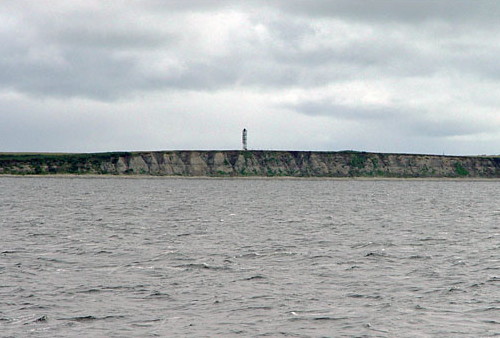
Date unknown. Active; focal plane 48 m (157 ft); one long green flash every 6 s. 22 m (72 ft) square steel skeletal tower carrying a slatted daymark painted black with a white vertical stripe. Evgeny Gusev's photo is at right but Google has only a distant satellite view of the area. Located about 1.1 km (0.7 mi) south of the rear light. Site status unknown. RU 2111-2261; ex-Admiralty L8270.1.
Chernilovskiy Range Rear
Date unknown. Active; focal plane 22 m (72 ft); one long white flash every 6 s. 15 m (49 ft) square steel skeletal tower carrying a slatted daymark painted white with a black vertical stripe. No photo available and Google has only a distant satellite view of the area. This is an upstream range guiding vessels leaving the delta. The front light is on a 9 m (30 ft) tower. Located on the west side of the river opposite the Muksuninskiy Range (previous entries). Site status unknown. RU 2111-2281; ex-Admiralty L8272.1.
Lugovoy Range Rear
Date unknown. Active; focal plane 22 m (72 ft); one long white flash every 6 s. 15 m (49 ft) square steel skeletal tower carrying a slatted daymark painted white with a black vertical stripe. No photo available and Google has only a distant satellite view of the area. This is a downstream range. Located on the west side of the river a short distance south of the Chernilovskiy Range. Site status unknown. RU 2111-2203; ex-Admiralty L8276.1.
Lugovoy Range Front
Date unknown. Active; focal plane about 18 m (59 ft); white flash every 1.5 s. 15 m (49 ft) square steel skeletal tower carrying a slatted daymark painted black with a white vertical stripe. No photo available and Google has only a distant satellite view of the area. Located about 750 m (0.47 mi) southwest of the rear light. Site status unknown. RU 2111-2202; ex-Admiralty L8276.
Muksuninskiy Range Rear Light
photo copyright Evgeny Gusev; used by permission
Verkhne Golovinskiy Range Front
Date unknown. Active; focal plane 19 m (62 ft); white flash every 1.5 s. 12 m (39 ft) square pyramidal skeletal tower carrying a slatted daymark painted white with a black vertical stripe. No photo available but Google has a satellite view. This is an upstream range. Located on the south point of an island on the west side of the river just above the delta. Site status unknown. RU 2111-2325; ex-Admiralty L8280.
Verkhne Golovinskiy Range Rear (2)
Date unknown. Active; focal plane 28 m (92 ft); one long white flash every 6 s. 21 m (69 ft) square steel skeletal tower carrying a slatted daymark painted white with a black vertical stripe. No photo available but Google has a satellite view. The original light tower was replaced in 2008. Located about 750 m (0.47 mi) south of the rear light. Site status unknown. RU 2111-2326; ex-Admiralty L8280.1.

Yenisey River Lighthouses between the Delta and Dudinka
Nizhne Sechenskiy Range Rear
Date unknown. Active; focal plane 81 m (266 ft); one long red flash every 6 s. 15 m (49 ft) square skeletal tower carrying a slatted daymark painted white with a black vertical stripe. No photo available but Google has a good satellite view. This is a downstream range guiding vessels on a long south to north reach approaching the village of Karaul. Located on the east side of the river about 5 km (3 mi) east of Karaul. Site status unknown. RU 2111-2381; ex-Admiralty L8288.1.
Nizhne Sechenskiy Range Front
Date unknown. Active; focal plane 61 m (200 ft); red flash every 1.5 s. 12 m (39 ft) square skeletal tower carrying a slatted daymark painted black with a white vertical stripe. No photo available but Google has a good satellite view. Located about 700 m (2300 ft) south of the rear light. Site status unknown. RU 2111-2380; ex-Admiralty L8288.
Mys Kazantsevskiy (Range Front)
Date unknown. Active; focal plane 49 m (161 ft); white flash every 1.5 s. 13 m (43 ft) square skeletal tower. This light is one the left in Gusev's distant view and Google has an indistinct satellite view. Google also has a satellite view of the rear beacon, the taller tower on the right in Gusev's view; it is listed only as a daybeacon. This is an upstream range. Located on the east bank of the river at Kazantsevo. Site status unknown.
Selyakino (Mys Selyakin) Range Rear
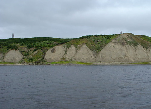
Date unknown. Active; focal plane 74 m (243 ft); one long white flash every 6 s. 12 m (49 ft) square pyramidal skeletal tower carrying a slatted daymark painted white with a black vertical stripe. Evgeny Gusev's photo is at right and Google has a satellite view. This is a downstream range guiding vessels on a long south to north reach approaching a high bluff called Mys (Cape) Selyakin. Located on the east side of the river near the settlement of Selyakino. Site status unknown. RU 2111-2431; ex-Admiralty L8296.1.

Mys Selyakin Range Front (right) and Rear Lights
photo copyright Evgeny Gusev; used by permission
Selyakino (Mys Selyakin) Range Front
Date unknown. Active; focal plane 61 m (200 ft); red flash every 1.5 s. 12 m (39 ft) square skeletal tower carrying a slatted daymark painted black with a white vertical stripe. Evgeny Gusev's photo is at right and Google has a satellite view. Located about 370 m (1215 ft) south of the rear light. Site status unknown. RU 2111-2430; ex-Admiralty L8296.
Yuzhno-Krestovskiy Range Front
Date unknown. Active; focal plane 62 m (203 ft); white flash every 1.5 s. 13 m (43 ft) square skeletal tower carrying a slatted daymark painted white with a black vertical stripe. No photo available but Google has a satellite view. This is an upstream range. Located on the east side of the river about halfway between Dudinka and the delta. Site status unknown. RU 2111-2500; ex-Admiralty L8314.
Yuzhno-Krestovskiy Range Rear
Date unknown. Active; focal plane 85 m (279 ft); one long white flash every 6 s. 18 m (59 ft) square skeletal tower carrying a slatted daymark painted white with a black vertical stripe. No photo available but Google has a satellite view. Located about 580 m (0.36 mi) northeast of the rear light. Site status unknown. RU 2111-2501; ex-Admiralty L8314.1.
Novoselenskiy Range Rear
Date unknown. Active; focal plane 60 m (197 ft); white flash every 1.5 s. 8 m (26 ft) (?) square skeletal tower. Lightphotos.net has Gusev's photo (seen at the top of this page) and Google has a satellite view. This range leads vessels northward away from Dudinka. The front light is on a shorter tower. Located on the east side of the river about 12 km (7.5 mi) north of Dudinka. Site status unknown. ex-Admiralty L8330.1.
Nizhne Dudinskiy Range Front
Date unknown. Abandoned but listed with focal plane 62 m (203 ft); white flash every 1.5 s. 13 m (43 ft) square skeletal tower carrying a slatted daymark painted white with a black vertical stripe. Alexander Smykov has a 2020 photo and Google has a satellite view. This is an upstream range. Located on a bluff about 3 km (2 mi) north of Dudinka; accessible by road. Site status unknown. RU 2111-2570; ex-Admiralty L8328.
Selyakino Range Front Light
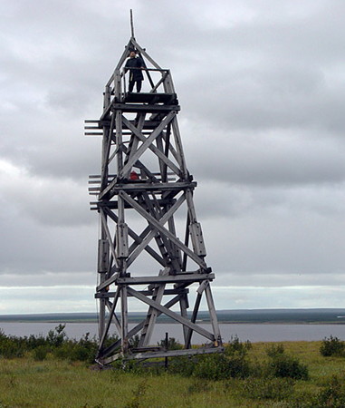
Selyakino (Mys Selyakin) Range Front Light
ex-Panoramio photo copyright Evgeny Gusev; used by permission
Nizhne Dudinskiy Range Rear
Date unknown. Abandoned but listed with focal plane 85 m (279 ft); one long white flash every 6 s. 18 m (59 ft) square skeletal tower carrying a slatted daymark painted white with a black vertical stripe. Gusev's photo is at right, Valentin Pshenichnikov has a street view and a second street view from inside this tower, and Google has a satellite view. Located about 610 m (2000 ft) southeast of the rear light; accessible by road from Dudinka. Site status unknown. RU 2111-2571; ex-Admiralty L8328.1.

Yenisey River Lighthouses between Dudinka and Igarka
Ostrovnoy-Gribanovskiy Range Rear
Date unknown. Active; focal plane 29 m (95 ft); one long red flash every 6 s. 15 m (49 ft) skeletal tower carrying a slatted daymark painted white with a black vertical stripe. No photo available but Google has a satellite view. This is an upstream range; the front light is on a similar 9 m (30 ft) tower. Located on an island about 20 km (13 mi) southwest of Dudinka. Site status unknown. RU 2111-2596; ex-Admiralty L8336.1.
Gribanovskiy Range Rear
Date unknown. Active; focal plane 46 m (151 ft); one long white flash every 6 s. 35 m (115 ft) skeletal tower carrying a slatted daymark painted white with a black (?) vertical stripe. No photo available but Google has a satellite view. This is an downstream range; the front light is on a similar 7 m (23 ft) tower. The stripe appears red in the satellite view. Located on the east side of the river about 5 km (3 mi) south of the Ostrovnoy-Gribanovskiy Range. Site status unknown. RU 2111-2626; ex-Admiralty L8344.1.

Nizhne Dudinskiy Range Rear Light
photo copyright Evgeny Gusev; used by permission
Vershininskiy Range Rear
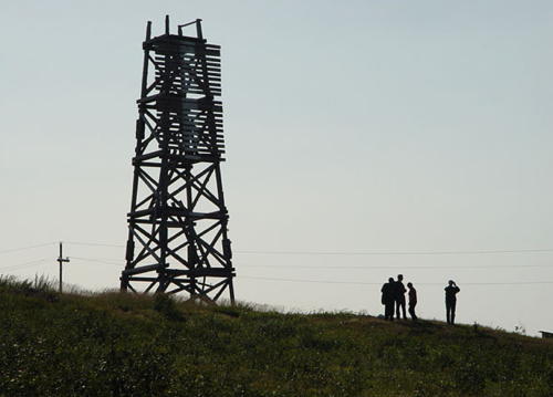
Date unknown. Active; focal plane 60 m (197 ft); one long red flash every 6 s. 15 m (49 ft) skeletal tower carrying a slatted daymark painted white with a black vertical stripe. No photo available but Google has a satellite view. This is a downstream range. Located on the east side of the river about 50 km (30 mi) south of Dudinka. Site status unknown. RU 2111-2661; ex-Admiralty L8350.1.
Vershininskiy Range Front
Date unknown. Active; focal plane 50 m (164 ft); red flash every 1.5 s. 15 m (49 ft) skeletal tower carrying a slatted daymark painted black with a white vertical stripe. No photo available but Google has a satellite view. Located 183 m (600 ft) south of the rear light. Site status unknown. RU 2111-2660; ex-Admiralty L8350.
Nikol'skiy North Range Rear
Date unknown. Active; focal plane 59 m (194 ft); one long white flash every 6 s. 15 m (49 ft) skeletal tower carrying a slatted daymark painted white with a black vertical stripe. No photo available but Google has a satellite view. This is a downstream range. Located on the east side of the river about 80 km (50 mi) south of Dudinka. Site status unknown. RU 2111-2666; ex-Admiralty L8352.1.
Nikol'skiy North Range Front
Date unknown. Active; focal plane 47 m (154 ft); white flash every 1.5 s. 12 m (39 ft) skeletal tower carrying a slatted daymark painted black with a white vertical stripe. No photo available but Google has a satellite view. Located 370 m (1215 ft) south of the rear light. Site status unknown. RU 2111-2665; ex-Admiralty L8352.
Nikol'skiy South Range Front
Date unknown. Active; focal plane 42 m (138 ft); white flash every 1.5 s. 15 m (49 ft) skeletal tower carrying a slatted daymark painted white with a black vertical stripe. No photo available but Google has a satellite view. This is a upstream range guiding vessels on a very long southbound reach. Located on the west side of the river about 100 km (60 mi) south of Dudinka. Site status unknown. RU 2111-2690; ex-Admiralty L8358.
Nikol'skiy South Range Rear
Date unknown. Active; focal plane 56 m (184 ft); one long white flash every 6 s. 15 m (49 ft) skeletal tower carrying a slatted daymark painted black with a white vertical stripe. No photo available but Google has the satellite view. seen at right. Located 740 m (0.46 mi) south of the front light. Site status unknown. RU 2111-2691; ex-Admiralty L8358.1.
Nosok Range Front
Date unknown. Active; focal plane 47 m (154 ft); white flash every 1.5 s. 12 m (39 ft) skeletal tower carrying a slatted daymark painted white with a black vertical stripe. No photo available but Google has a satellite view. This is a upstream range guiding vessels through a narrow stretch of the river. Located on the east side of the river about 160 km (100 mi) south of Dudinka. Site status unknown. RU 2111-2700; ex-Admiralty L8360.
Nosok Range Rear
Date unknown. Active; focal plane 55 m (180 ft); one long white flash every 6 s. 16 m (52 ft) skeletal tower carrying a slatted daymark painted black with a white vertical stripe. No photo available but Google has a satellite view. Located 480 m (0.3 mi) southeast of the front light. Site status unknown. RU 2111-2701; ex-Admiralty L8360.1.
Kychkovskiy Range Front
Date unknown. Active; focal plane 32 m (105 ft); white flash every 1.5 s. 13 m (43 ft) skeletal tower carrying a slatted daymark painted red with a white vertical stripe. No photo available and Google has only a blurry satellite view of the area. This is a upstream range guiding vessels on a long southbound reach. Located on the west side of the river about 150 km (95 mi) north of Igarka, opposite the mouth of the Khantayka River. Site status unknown. RU 2111-2810; ex-Admiralty L8376.
Kychkovskiy Range Rear
Date unknown. Active; focal plane 41 m (135 ft); one long white flash every 6 s. 15 m (49 ft) skeletal tower carrying a slatted daymark painted red with a white vertical stripe. No photo available and Google has only a blurry satellite view of the area. Located 370 m (1215 ft) south of the front light. Site status unknown. RU 2111-2811; ex-Admiralty L8376.1.

Nikol'skiy South Range Rear Light
Google Maps satellite view
Khantayskiy Range Front
Date unknown. Active; focal plane 38 m (125 ft); white flash every 1.5 s. 12 m (39 ft) skeletal tower carrying a slatted daymark painted white with a black vertical stripe. No photo available but Google has a satellite view. This is a upstream range. Located on the east side of the river just south of the mouth of the Khantayka River. Site status unknown. RU 2111-2825; ex-Admiralty L8380.
Khantayskiy Range Rear
Date unknown. Active; focal plane 47 m (154 ft); one long white flash every 6 s. 18 m (59 ft) skeletal tower carrying a slatted daymark painted white with a black vertical stripe. No photo available but Google has a satellite view. Located 260 m (850 ft) southeast of the front light. Site status unknown. RU 2111-2826; ex-Admiralty L8380.1.
Verkhne Khantayskiy Range Rear
Date unknown. Active; focal plane 51 m (167 ft); one long white flash every 6 s. 21 m (69 ft) skeletal tower carrying a slatted daymark painted white with a black vertical stripe. No photo available but Google has a satellite view. This is a downstream range guiding vessels on a long northbound reach approaching the Khantayka River. Located on the east side of the river about 5 km (3 mi) south of the Khantayka. Site status unknown. RU 2111-2841; ex-Admiralty L8384.1.
Verkhne Khantayskiy Range Front
Date unknown. Active; focal plane 33 m (108 ft); white flash every 1.5 s. 15 m (49 ft) skeletal tower carrying a slatted daymark painted black with a white vertical stripe. No photo available but Google has a satellite view. Located 550 m (1800 ft) southwest of the rear light. Site status unknown. RU 2111-2840; ex-Admiralty L8384.

Information available on lost lighthouses:

Notable faux lighthouses:

Adjoining pages: North: Yenisey Gulf

Return to the Lighthouse Directory index | Ratings key

Posted December 29, 2011. Checked and revised May 15, 2024. Lighthouses: 42. Site copyright 2024 Russ Rowlett and the University of North Carolina at Chapel Hill.