Lighthouses of Italy: Central and Southern Sardinia

Most of Italy (officially the Italian Republic, Repubblica Italiana in Italian) occupies a long peninsula in the Mediterranean Sea, with the Adriatic and Ionian Seas on the east and the Ligurian and Tyrrhenian Seas to the west; the country also includes the Mediterranean's two largest islands, Sicily and Sardinia, and many smaller islands. With this geography Italy has a very long coastline reckoned by geographers at about 7600 km (4722 mi). Guarding this coast are many lighthouses; the Directory lists more than 400.

Italy is divided into 20 regions (regioni) and the regions are subdivided into provinces. The region of Sardinia (Sardegna in Italian) is the second largest island of the Mediterranean, after Sicily; the island is about 270 km (170 mi) from north to south and 145 km (90 mi) from east to west. Most of Sardinia is mountainous and the coastline is rugged. The island has a long and complex history. After several centuries of Spanish rule the Kingdom of Sardinia became independent in 1718 under the rule of the House of Savoy. For many years after that the kings of Sardinia controlled substantial Savoyard territory on the mainland, including Genoa in Italy and Nice in France. And in 1861, when Italy was united as a single country, the king of Sardinia, Victor Emmanual II, became king of Italy.

In recent years there have been several changes in the division of the island into provinces. Since 2016 Sardinia has been divided into four provinces plus the metropolitan city of Cagliari. This page includes lighthouses of all of the island except the northern province of Sassari; Sassari lighthouses are on the Northern Sardinia page.

The Italian word for a lighthouse is faro, plural fari. This name is usually reserved for the larger coastal lights; smaller beacons are called fanali. In Italian isola is an island, isolotto is an islet, secca is a shoal, cabo is a cape, punta is a point of land, baia is a bay, stretto is a strait, fiume is a river, and porto is a harbor.

Aids to navigation in Italy are operated and maintained by the Italian Navy's Servizio dei Fari e del Segnalamento Marittimo (Lighthouse and Maritime Signal Service). Lighthouse properties are naval reservations, generally fenced and closed to the public.

ARLHS numbers are from the ARLHS World List of Lights. EF numbers are from the Italian Navy's light list, Elenco dei Fari e Segnali da Nebbia. Admiralty numbers are from volume E of the Admiralty List of Lights & Fog Signals. U.S. NGA List numbers are from Publication 113.

Special thanks to Egidio Ferrighi for his helpful comments on this page and to Michel Forand for sharing his extensive and careful research on Italian lighthouses.


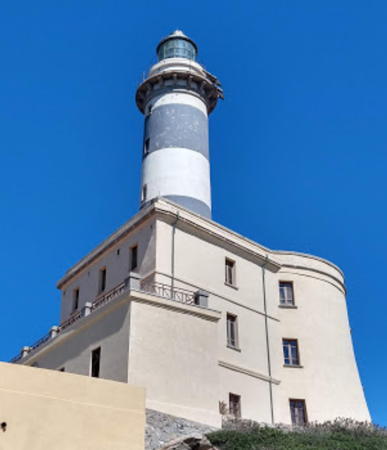
Isola dei Cavoli Light, Villasimius, August 2020
Google Maps photo by Franco Rondoni

General Sources
Fari e Segnalamenti
Lighthouse information from the Italian Navy's Servizio dei Fari.
Online List of Lights - Italy
Photos by various photographers posted by Alexander Trabas. Many of the photos for Sardinia are by Egidio Ferrighi, Arno Siering, or Capt. Peter Mosselberger ("Capt. Peter").
Fari Sardegna
Photos posted by Andrea Utzeri.
Lighthouses in Sardinia
Photos by various photographers available from Wikimedia.
World of Lighthouses - Italy
Photos by various photographers available from Lightphotos.net.
Lighthouses in Italy
Aerial photos posted by Marinas.com.
Cyberlights Lighthouses - Italy - Sardegna
Photos of Sardinian lighthouses by Egidio Ferrighi, posted by Gary Richardson and Anna Klein.
Italienische Leuchttürme auf Historischen Postkarten
Historic postcard images posted by Klaus Huelse.
GPSNauticalCharts
Navigational chart for Sardinia.
Navionics Charts
Navigation chart for Sardinia.
 

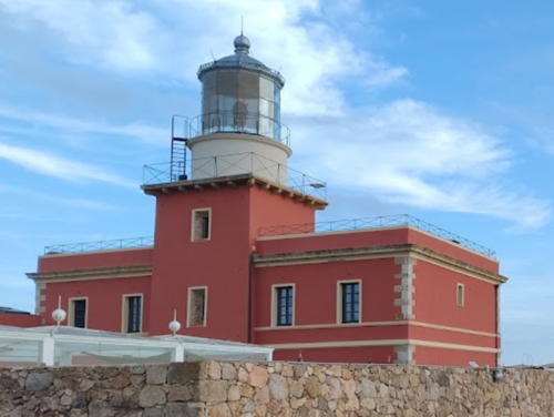
Capo Spartivento Light, Domus de Maria, October 2023
Google Maps photo by Jean Marc Fabre

Nuoro Province (Central East Coast) Lighthouses

Siniscola Lighthouse
* Capo Comino
1925. Active; focal plane 26 m (85 ft); white flash every 5 s. 20 m (66 ft) square cylindrical tower with lantern and gallery, attached to the seaward end of a 3-story keeper's house. Entire lighthouse painted white; lantern dome is gray metallic. Steffi Fielitz has the 2020 aerial view at right, Ferrighi has a photo, the Navy has a page for the lighthouse, Trabas has a closeup photo by Siering, another good photo is available, Wikimedia has numerous photos, Marinas.com has aerial photos, and Google has a street view and a satellite view. This lighthouse was actually built in 1903, and many sources have this date, but it was not activated until 1925. In 2015 the Navy offered a long-term lease of the light station for restoration and tourist development. Located on the point of the cape, about 15 km (9 mi) southeast of Siniscola. Accessible by road; parking provided. Site open, tower closed. . ARLHS SAR-011; EF-1230; Admiralty E1030; NGA 8588.

Arbatax Lighthouses
Arbatax is a town of about 5000 residents and one of the few good ports on the central east coast of Sardinia. It is the terminal for ferries from Civitavecchia north of Rome.

* Arbatax Molo di Ponente
Date unknown. Active; focal plane 13 m (43 ft); flash every 3 s, white or red depending on direction. 10 m (33 ft) bottle-style post light centered on a round 1-story stone base. Post light painted green; the base is unpainted. Trabas has a closeup photo by Capt. Peter and Google has a satellite view and a street view across the harbor. Located at the end of the mole enclosing the west side of the inner harbor of Arbatax. Accessible by walking the mole. Site open, tower closed. EF-1242; Admiralty E1036; NGA 8572.

Capo Comino Light, Siniscola, October 2020
Google Maps photo by Steffi Fielitz
* Arbatax Molo di Levante Spur
Date unknown. Active; focal plane 9 m (30 ft); red flash every 5 s. 8 m (26 ft) round masonry or concrete tower mounted on a stone base. Tower painted white with a red band at the top; the base is unpainted. Trabas has a closeup photo by Capt. Peter and Google has a street view and a satellite view. Located at the end of the mole enclosing the east side of the inner harbor of Arbatax. Accessible by walking the mole. Site open, tower closed. EF-1236; Admiralty E1034; NGA 8568.
* Arbatax Molo di Levante
Date unknown. Active; focal plane 14 m (46 ft); continuous red light. 6 m (20 ft) round cylindrical stone tower with lantern and gallery. The tower is made with red and white stones; lantern painted red with a gray metallic roof. Trabas has a photo by Capt. Peter, Carmelo Tommaso Russo has a view from the sea, and Google has a satellite view. Located at the end of the breakwater mole on the east side of the harbor of Arbatax. Site status unknown, but the mole appears to be walkable. ARLHS SAR-029; EF-1235; Admiralty E1033; NGA 8569.
* Capo Bellavista
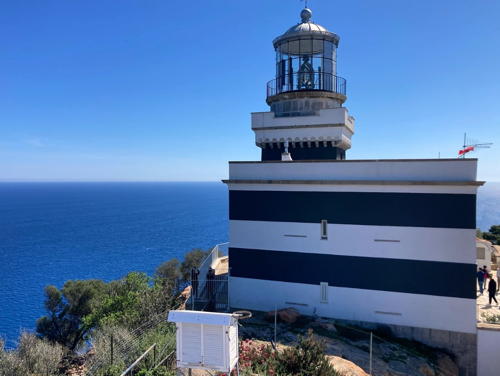
1866. Active; focal plane 165 m (541 ft); two white flashes every 10 s. 19 m (62 ft) square cylindrical tower with lantern and gallery, attached to the seaward end of a 2-story keeper's house. Originally painted in black and white horizontal bands, although these faded and disappeared for many years. In 2020-21 the lighthouse was restored and repainted in the black and white bands as seen in the 2024 photo at right, Trabas has a photo by Werner Seiler, Alberto Mula has a fine 2019 photo, Patrizia Congiu has a 2018 photo, and Google has a satellite view. This powerful lighthouse has a range of 26 nautical miles (48 km or 30 mi). Both cape and lighthouse are well named for the spectacular view. Located on a high promontory at Arbatax on the central east coast of Sardinia; accessible by the many switchbacks of the Via Faro Bellavista. Site open, tower closed. . ARLHS SAR-008; EF-1246; Admiralty E1032; NGA 8564.

Capo Bellavista Light, Arbatax, March 2024
Instagram photo by Agata M

Sud Sardegna (South Sardinia) Province East Coast Lighthouses

Castiadas Lighthouse
* Capo Ferrato
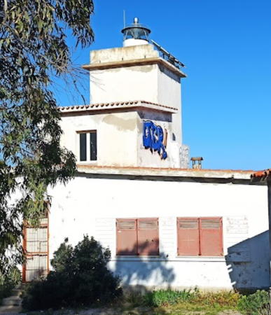
1925. Active; focal plane 51 m (167 ft); three white flashes every 10 s. 11 m (36 ft) square cylindrical masonry tower with lantern and gallery, attached to the seaward side of a 2-story keeper's house. Entire lighthouse painted white; lantern dome is gray metallic. Daniele Sarritzu's 2023 photo is at right, Trabas has Ferrighi's photo, Maria Luisa Fercia has a closeup photo, a view from the sea is available, the Navy has a page for the lighthouse, Marinas.com has aerial photos, Gabriele Sala has a distant street view, and Google has a satellite view. The tower is original but the house was rebuilt in 1955. A new lantern was installed in 1966. The house has been privately owned since the lighthouse was automated in 1976. In 2003 the local tourist association proposed that it should be bought and converted to a museum. However, the owners don't wish to sell and nothing has come of this idea so far. Located at the end of a very sharp promontory about 14 km (9 mi) northeast of Castiadas and 25 km (15 mi) north of Capo Carbonara. Site and tower closed (private property), although the lighthouse can be seen from nearby. . ARLHS SAR-013; EF-1250; Admiralty E1042; NGA 8560.

Villasimius Lighthouses
Secca dei Berni (2?)
Date unknown (station established 1902). Active; focal plane 9 m (30 ft); two white flashes every 6 s. 8 m (26 ft) round strongly conical stone tower with a short post light at the peak. The stone tower is unpainted; the post is black with a red horizontal band. Trabas has Ferrighi's closeup photo and Bing has a satellite view. The Jenkins 1904 light list describes the beacon as cylindrical rather than conical. Located on a reef about 1.5 km (1 mi) offshore and 5 km (3 mi) northeast of Capo Carbonara. Accessible only by boat. Site open; there's no obstacle to climbing the external ladder of the tower. EF-1254; Admiralty E1044; NGA 8556.
Isola dei Cavoli
1858. Active; focal plane 74 m (243 ft); two flashes every 10 s, white or red depending on direction. 37 m (121 ft) round masonry tower with lantern and gallery, attached to a large 3-story, fortress-like keeper's house. Tower painted with black and white horizontal bands; lantern dome is gray metallic. Franco Rondoni's photo is at the top of this page, Navy has a page for the lighthouse, Trabas has Ferrighi's closeup photo, Ferrighi also has a view from the sea, Wikimedia has a view from the sea, Marinas.com has aerial photos, Máté Szekeres has a closeup street view, and Google has a satellite view. The Isola dei Cavoli (Island of Cabbages) is a rocky 40 hectare (100 acre) island about 800 m (1/2 mi) southeast of Capo Carbonara. The island is a research reserve administered by the Università di Cagliari. Located on the highest point of the island. Accessible only by boat; there are good views from the Capo Carbonara lighthouse. Site open, tower closed. Site manager: Università di Cagliari. . ARLHS SAR-001; EF-1262; Admiralty E1048; NGA 8552.

Capo Ferrato Light, Castiadas, April 2023
Google Maps photo by Daniele Sarritzu
Capo Carbonara
1974. Active; focal plane 120 m (394 ft); white flash every 7.5 s. 5 m (17 ft) round masonry tower with lantern and gallery, painted white; lantern dome is gray metallic. Adjacent 2-story masonry keeper's house. The Navy has a page for the lighthouse, Trabas has Ferrighi's closeup photo, Adriano Trento has a photo of the station, Marinas.com has aerial photos, and Google has a satellite view and a distant street view from the station entrance. The original light was described as a skeletal tower. Capo Carbonara, the southeastern corner of Sardinia, juts out from the coast at San Stefano. Located just southeast of the town. Site and tower closed. ARLHS SAR-010; EF-1258; Admiralty E1043; NGA 8548.

Metropolitan City of Cagliari Lighthouses

Cagliari is the capital, largest city, and most important port of Sardinia. The urban population is about 150,000 but the metropolitan population is about 475,000.

* Cagliari (Capo Sant'Elia)
1860. Active; focal plane 70 m (230 ft); two white flashes every 10 s. 21 m (69 ft) round masonry tower with lantern and gallery, attached to a 2-story masonry keeper's house. Lighthouse painted with black and white horizontal bands; lantern dome is gray metallic. Giuseppe Perillo's 2023 photo is at right, Trabas has the photo by Capt. Peter, Ferrighi has a photo, a 2020 photo is available, Michael Peters has an aerial photo, and Google has a street view and a satellite view. The Torre di Calamosca, a late medieval watch tower, stands near the lighthouse. This traditional landfall light for Cagliari is located on a promontory on the southeast side of the city, at the end of the Via Faro. Site open, tower closed. . ARLHS SAR-019; EF-1270; Admiralty E1054; NGA 8532.
* Cagliari Nuovo Molo di Levante (East Breakwater)
Date unknown (station established 1856). Active; focal plane 13 m (43 ft); green flash every 3 s. 11 m (36 ft) tapered round concrete tower with lantern and gallery. Tower painted white; lantern and gallery painted green; lantern roof is gray metallic. Trabas has a photo, Angelo Cefalù has a 2019 photo, Enrico M. Pisu has a closeup 2022 photo, and Google has a satellite view. Located at the end of the east breakwater of the traditional (eastern) harbor. Accessible by walking the mole. Site open, tower closed. ARLHS SAR-041; EF-1276; Admiralty E1057; NGA 8502.


Capo Sant'Elia Light, Cagliari, February 2023
Google Maps photo by Giuseppe Perillo

* Cagliari Nuovo Molo di Ponente (West Breakwater)
Date unknown (station established 1856). Active; focal plane 13 m (43 ft); red flash every 3 s. 11 m (36 ft) tapered round concrete tower with lantern and gallery. Tower painted white; lantern and gallery painted red; lantern roof is gray metallic. Anna Scanu has a photo, Trabas has a closeup, Paolo Belluz has a 2021 photo, Francesco Cubeddu has a 2022 closeup, and Google has a satellite view. A new harbor has been built recently at Cagliari, but this lighthouse is located at the end of the west breakwater of the traditional (eastern) harbor. Accessible by walking the mole. Site open, tower closed. ARLHS SAR-040; EF-1277; Admiralty E1056.2; NGA 8500.
[Cagliari Molo Settentrionale]
Date unknown. Active (privately maintained); focal plane about 10 m (33 ft); two green flashes every 6 s. Approx. 6 m (20 ft) green bottle-style light on a square concrete base. Trabas has Capt. Peter's photo and Google has a satellite view. Located on the east breakwater of the industrial harbor. Site and tower closed. EF-1293; Admiralty E1065.62; NGA 8503.2.
[Cagliari Molo Meridionale]
Date unknown. Active (privately maintained); focal plane about 10 m (33 ft); two red flashes every 6 s. Approx. 6 m (20 ft) red bottle-style light on a square concrete base. Trabas has Ferrighi's photo and Google has a satellite view. Located on the west breakwater of the industrial harbor. Site and tower closed. Admiralty E1065.61; NGA 8503.25.
* Pula (Capo di Pula, Torre di Sant'Efisio, Torre del Coltellazzo)
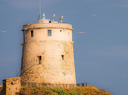
Date unknown. Active; focal plane 48 m (157 ft); four white flashes every 15 s. 16 m (52 ft) massive round stone defensive tower with a small lantern on the roof. The tower is unpainted. A 2022 photo is at right, Trabas has a fine photo by Capt. Peter, Nina Pikula has a 2021 photo, Yidian Dong has a photo, Angelo Tolu has a fine view, Sander Suharov has a street view, and Google has a satellite view. This is an early 17th century Spanish tower, one of many on the Sardinian coast. The light marks the western entrance to the Golfo di Cagliari. Located on a promontory overlooking the harbor of Pula. Accessible by road. Site open, tower closed. ARLHS SAR-012; EF-1305; Admiralty E1070; NGA 8452.

Torre di Sant'Efisio Light, Pula, October 2022
Instagram photo by Fabian

Sud Sardegna (South Sardinia) Province West Coast Lighthouses

Capo Spartivento Lighthouse
* Capo Spartivento
1866. Active; focal plane 81 m (266 ft); three white flashes every 15 s. 19 m (62 ft) square cylindrical masonry tower with lantern and gallery, rising from the landward side of a 2-story masonry keeper's house. Lighthouse painted brick red with white trim, light tower white; the lantern dome is gray metallic. A 2023 photo by Jean Marc Fabre is at the top of this page, the Navy has a page for the lighthouse, a photo of the lighthouse in action is available, Trabas has Ferrighi's photo, Marinas.com has aerial photos, Fabiano Baderna has a street view, and Google has a satellite view. This famous lighthouse marks the southernmost tip of Sardinia. After automation the condition of the lighthouse deteriorated and it was damaged several times by vandals. However, the lighthouse has now been restored and it looked great in Maurizio Agelli's January 2007 photo. The restoration was part of a project to convert the light station into a luxury resort. Note: there is another Capo Spartivento, also with a famous lighthouse, at the southern tip of the Italian mainland in Calabria. Located on the point of the cape about 3 km (2 mi) southwest of Chia. Accessible by road. Site open, tower closed. Site manager: Faro Capo Spartivento . ARLHS SAR-020; EF-1310; Admiralty E1072; NGA 8448.

Sant'Antioco Lighthouses
* Ponte Romano (Sant'Antioco) (2)
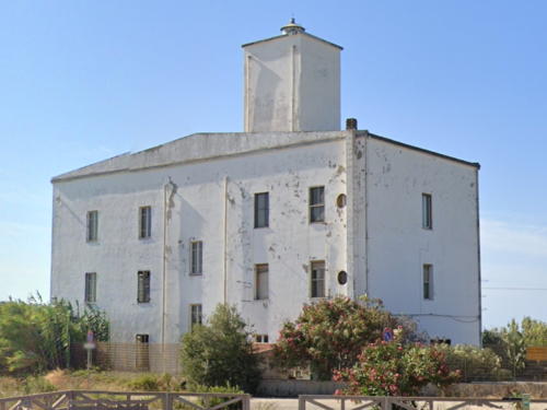
Date unknown (station established 1924). Active; focal plane 23 m (75 ft); white flash every 5 s. 22 m (72 ft) square cylindrical masonry tower with lantern and gallery, rising from the center of a 3-story keeper's house. Entire lighthouse painted white; lantern dome is gray metallic. Google's 2023 street view is at right, Siering has a good photo, the Navy has a page for the lighthouse, Trabas has an excellent photo by Capt. Peter, Utzeri has many photos, Eleonora Vendetta has a 2021 photo, and Google has a satellite view. The original light was on a skeletal tower. Older photos of the present lighthouse show it was formerly painted with black and white horizontal bands. A sand spit nearly connects the island of Sant'Antioco to the mainland of Sardinia and the Romans closed the gap with a bridge in the early third century AD. The modern crossing is a causeway with a short bridge at the Sant'Antioco end. The original Roman bridge is beside the modern road. The lighthouse is located near the center of the causeway, beside the SS126 highway. Site open, tower closed. . ARLHS SAR-045; EF-1315; Admiralty E1080; NGA 8440.
Isolotto Il Vacca
Date unknown. Inactive. 7 m (23 ft) square stone tower; the lantern has been removed. Alessandro Cabras has a 2020 photo, the tower is seen in a distant sea view by Paolo and Mauro Mattiello and Google has a satellite view. Il Vacca (The Cow) is in the same island group as Il Toro (next entry). Located on the highest point of the island, about 4 km (2.5 mi) southeast of Capo Sperrone. Accessible only by boat. Site status unknown.
Isolotto Il Toro
Date unknown. Active; focal plane 118 m (387 ft); two flashes every 6 s, white or red depending on direction. 5 m (17 ft) post light centered on a square 1-story equipment shelter. Entire lighthouse is white. Utzeri has a distant view, Roberto Pintus has a view from the sea, Trabas has Eckhard Meyer's distant view, and Google has an indistinct satellite view. Il Toro (The Bull) is the tallest of three small islands about 10 km (6 mi) south of Capo Sperrone, the southern tip of the Isola di Sant'Antioco. Accessible only by boat. Site status unknown. ARLHS SAR-004; EF-1343; Admiralty E1074; NGA 8436.

Ponte Romano Light, Sant'Antioco, August 2023
Google Maps street view
Scoglio Mangiabarche
1935. Active; focal plane 12 m (39 ft); white flash every 6 s. 11 m (36 ft) round stone tower with a small lantern and gallery, painted white. The name mangiabarche means "boat-eater," a reference to the dangerous shoals nearby. The Navy has a page for the lighthouse, Trabas has a nice photo by Siering, Luciano Manconi has a 2021 photo, Giuseppe Melis has a fine 2009 photo, Giampaolo Puddu has a photo of waves breaking around the tower, and Google has a satellite view. Lighthouse Digest has a June 2000 article on the lighthouse, but note that the light has been renovated and repainted since that time. Located off the northwest point of the Isola di Sant'Antioco, marking the 2.4 km (1.5 mi) wide channel between that island and the Isola di San Pietro. Accessible only by boat, although there is a good view from the shore. Site and tower closed. . ARLHS SAR-038; EF-1348; Admiralty E1086; NGA 8428.

Carloforte (Isola di San Pietro) Lighthouses
The Isola di San Pietro (St. Peter's Island) lies 7 km (4 mi) off the coast of Sardinia and 5 km (3 mi) northwest of the Isola di Sant'Antioco. Carloforte, the only town on the island, has a population of about 6500 and is accessible by ferry from Portoscuso.
* Carloforte Campanile Duomo (Entrance Range Front)
Date unknown. Active; focal plane 23 m (75 ft); continuous red light. 22 m (72 ft) cream-colored square bell tower with a small white dome. Giulio Gardu has a closeup of the tower; the light is mounted on a bracket in front of the railing, below the bell. Another photo shows the light at night, Trabas has a photo by Ferrighi, and Google has a street view and a satellite view. Trabas also has Eckhard Meyer's photo of the rear light on a wall, painted with black and white horizontal bands. Located in the center of Carloforte, the principal town of the Isola di San Pietro. Site open, tower closed. ARLHS SAR-044; EF-1365; Admiralty E1093; NGA 8388.
Carloforte Casa Fanalista Range Front
Date unknown. Active; focal plane 11 m (36 ft); continuous red light. 8 m (26 ft) light mounted on a corner of a 2-story building. Next to the building is a 15 m (49 ft) square solid daybeacon, painted with black and white horizontal bands; the corner of the building is also painted with black and white horizontal bands. Trabas has Ferrighi's photo and Google has a street view and a satellite view. Trabas also has Darlene Chisholm's photo of the rear light mounted low on a 4 m (13 ft) stone obelisk. Casa fanalista is a lightkeeper's house. Located on the south end of the Carloforte waterfront. Site open, tower closed. EF-1361; Admiralty E1094; NGA 8412.
* Capo Sandalo
1864. Active; focal plane 134 m (440 ft); four white flashes every 20 s. 30 m (98 ft) round stone tower with lantern and gallery, attached to the front of a 2-story stone keeper's house. 1st order Fresnel lens in use. The lighthouse is unpainted stone; lantern dome is gray metallic. Michele Vacca's 2023 photo is at right, the Navy has a page for the lighthouse, Trabas has a photo by Ferrighi, Francesco Parodo has a fine closeup of the tower and lens, Janos Szeplaki has a 2021 photo, and Google has a street view and a satellite view. This magnificent lighthouse marks the southwestern corner of Sardinia. The lighthouse is (or was recently) staffed. Located at the end of the SP104 highway on the western coast of the Isola di San Pietro. Site open; at least one visitor was able to secure a tour from the keeper. . ARLHS SAR-018; EF-1384; Admiralty E1090; NGA 8432.
Isola Piana
Date unknown. Active; focal plane 18 m (59 ft); two flashes every 8 s, white or red depending on direction. 8 m (26 ft) round cylindrical tower with gallery, painted white. A 2017 photo is available, Trabas has Eckhard Meyer's photo, and Google has a satellite view. Piana is a small island off the northeastern corner of the Isola di San Pietro. Located on the northern tip of the island, marking the northwestern entrance to the Canale di San Pietro, the channel between the Isola di San Pietro and the mainland of Sardinia. Accessible only by boat; the island has a small harbor and docking facilities are available. Site open, tower closed. ARLHS SAR-025; EF-1382; Admiralty E1103; NGA 8360.

Capo Sandalo Light, Isola di San Pietro, March 2023
Instagram photo by Michele Vacca

Portoscuso Lighthouse
La Ghingetta (Portoscuso) (2)
Date unknown (station established 1919). Active; focal plane unknown; two flashes every 10 s, white or red depending on direction. Approx. 11 m (36 ft) tapered round tower, painted with red and black horizontal bands. The Navy has a page for the lighthouse, Trabas has a photo by Capt. Peter, Fabio Murru also has a photo, Sarduseu Sutidu has a closeup, and Google has a satellite view. The original light was described as a skeletal tower. Located on a rocky reef (Scoglio la Ghinghetta) off the harbor of Portoscuso, a port of about 5000 residents. Accessible only by boat but there is an excellent view from ferries leaving Portoscuso for Carloforte on the Isola di San Pietro. Site and tower closed. . ARLHS SAR-034; EF-1376; Admiralty E1099; NGA 8364.

Capo Frasca Lighthouse
Capo Frasca (2)
Date unknown. Active; focal plane 66 m (217 ft); white flash every 6 s. 8 m (26 ft) round round post light with lantern and gallery, centered on a square 1-story concrete equipment building. Lighthouse painted white. Trabas has Eckhard Meyer's very distant view and Google has a satellite view. The first lighthouse was described as a 5 m (17 ft) square tower. The area surrounding this light is a naval base also used for NATO forces training. Located on the point of Capo Frasca, marking the south side of the entrance to the Golfo di Oristano. Site and tower closed. ARLHS SAR-050; EF-1386; Admiralty E1104; NGA 8356.

Oristano Province Lighthouses

Oristano Area Lighthouses
* Oristano (Gran Torre di Oristano, Torre Spagnola)
Date unknown (station established at least by 1919). Inactive since 2019. 16 m (52 ft) massive round defensive tower, 20 m (66 ft) in circumference, with a lantern room on the roof. The tower is unpainted stone; the lantern room is painted white. The light was displayed through a bay window in the front of the lantern room. Roberto Cocco has a 2021 photo, Wikimedia has numerous photos, and Google has a street view and a satellite view. The largest of all the Sardinian coastal towers, the Torre Spagnola was built in the early 1500s with later additions. Located in Marina di Torre Grande, about 6.5 km (4 mi) west of Oristano at the northern end of the Golfo di Oristano. Site open, tower status unknown. ARLHS SAR-022; ex-EF-1394; ex-Admiralty E1106; NGA 8324.
* Capo San Marco
1924. Active; focal plane 57 m (187 ft); two white flashes every 10 s. 15 m (49 ft) square masonry tower with lantern and double gallery, attached to the seaward side of a 2-story masonry keeper's house. The lighthouse is unpainted stone; lantern dome is gray metallic. Giovanni Sanna's 2021 photo is at right, the Navy has a page for the lighthouse, Trabas has Ferrighi's photo, a fine 2008 view is available, Mike Nesius has a street view, and Google has a satellite view. Elisabetta Deriu, the last keeper of the lighthouse and believed to be the only female light keeper in Italy, kept the light to the age of 82. The lighthouse is at the end of the narrow Penisola del Sinis, which also features a defensive tower thought to have built in Gothic times (around 500 AD). Located at the end of the SP6 highway in Cabras, marking the northern entrance to the Golfo di Oristano. Site open, tower closed. ARLHS SAR-017; EF-1390; Admiralty E1108; NGA 8320.

Capo Mannu Area Lighthouses
Isola di Mal di Ventre
Date unknown. Active focal plane 26 m (85 ft); flash every 6 s, white or red depending on direction. 8 m (26 ft) post atop a square 1-story equipment shelter. Lighthouse painted white. The Navy has a page for the lighthouse, Pittalis Gavino Franco has a 2022 photo, Trabas has Eckhard Meyer's distant view, and Google has a satellite view. The Isola di Mal di Ventre (the name means Foulwind Island) is a low, dangerous island about 1.8 m (1.1 mi) long surrounded by rock reefs. Located about 10 km (6 mi) west southwest of Porto Mandriola. Accessible only by boat. Site open, tower closed. ARLHS SAR-003; EF-1402; Admiralty E1111; NGA 8316.

Capo San Marco Light, Cabras, June 2021
Google Maps photo by Giovanni Sanna
* Capo Mannu
1960. Active; focal plane 59 m (194 ft); three long (1.5 s) white flashes every 15 s. 11 m (36 ft) square cylindrical tower with lantern and gallery, rising from the center of a 1-story masonry keeper's house. Lighthouse painted white. The Navy has a page for the lighthouse, 2009 photo is available, Trabas has a closeup photo by Capt. Peter, Maciej Chyra has a 2021 photo, a 2022 photo is available, and Google has a street view and a satellite view. Ferrighi reports that this lighthouse is in very poor condition. Capo Mannu is highly exposed to the waves and is a favorite spot for surfers. Located at the end of a promontory pointing westward from Porto Mandriola. Site open, tower closed. ARLHS SAR-016; EF-1404; Admiralty E1112; NGA 8312.

Bosa Lighthouse
* [Bosa Marina (1?)]
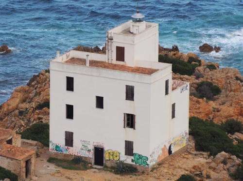
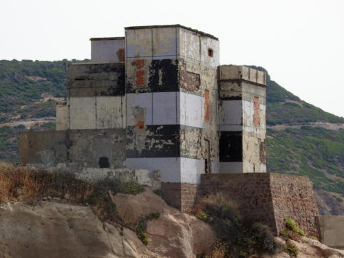
Date unknown (station established 1883). Inactive for many years. 3- or 4-story masonry keeper's house, painted originally with black and white horizontal bands although most of the paint has faded away. Capt. Peter Mosselberger's photo is at right and Google has a street view and a satellite view. The lighthouse stands seaward of a 15th century Aragonese watchtower. A breakwater mole has been built extending southward from the lighthouse and the active light, at the end of the mole, is a 7 m (23 ft) red post displaying a continuous red light. Various proposals to restore the lighthouse as a tourist attraction have come to nothing and the building is falling into ruin. Located on Isola Rossa, an island sheltering the harbor of Bosa Marina. Accessible by walking the mole that connects the island to the mainland. Site open, building closed. Active light: EF-1407; Admiralty E1116.5; NGA 8309.

Information available on lost lighthouses:


  • Bosa Marina Light, Bosa Marina, September 2021
    photo copyright Capt. Peter Misselberger; used by permission

    Notable faux lighthouses:

    Adjoining pages: North: Northern Sardinia | South: Western Sicily

    Return to the Lighthouse Directory index | Ratings key

    Posted May 24, 2006. Checked and revised March 24, 2024. Lighthouses: 29. Site copyright 2024 Russ Rowlett and the University of North Carolina at Chapel Hill.