Lighthouses of Italy: Northern Sardinia

Most of Italy (officially the Italian Republic, Repubblica Italiana in Italian) occupies a long peninsula in the Mediterranean Sea, with the Adriatic and Ionian Seas on the east and the Ligurian and Tyrrhenian Seas to the west; the country also includes the Mediterranean's two largest islands, Sicily and Sardinia, and many smaller islands. With this geography Italy has a very long coastline reckoned by geographers at about 7600 km (4722 mi). Guarding this coast are many lighthouses; the Directory lists more than 400.

Italy is divided into 20 regions (regioni) and the regions are subdivided into provinces. The region of Sardinia (Sardegna in Italian) is the second largest island of the Mediterranean, after Sicily; the island is about 270 km (170 mi) from north to south and 145 km (90 mi) from east to west. Most of Sardinia is mountainous and the coastline is rugged. The island has a long and complex history. After several centuries of Spanish rule the Kingdom of Sardinia became independent in 1718 under the rule of the House of Savoy. For many years after that the kings of Sardinia controlled substantial Savoyard territory on the mainland, including Genoa in Italy and Nice in France. And in 1861, when Italy was united as a single country, the king of Sardinia, Victor Emmanual II, became king of Italy.

In recent years there have been several changes in the division of the island into provinces. Since 2016 Sardinia has been divided into four provinces plus the metropolitan city of Cagliari. This page includes the lighthouses of the northern Sassari Province.

The Italian word for a lighthouse is faro, plural fari. This name is usually reserved for the larger coastal lights; smaller beacons are called fanali. In Italian isola is an island, isolotto is an islet, secca is a shoal, cabo is a cape, punta is a point of land, baia is a bay, stretto is a strait, fiume is a river, and porto is a harbor.

Aids to navigation in Italy are operated and maintained by the Italian Navy's Servizio dei Fari e del Segnalamento Marittimo (Lighthouse and Maritime Signal Service). Lighthouse properties are naval reservations, generally fenced and closed to the public.

ARLHS numbers are from the ARLHS World List of Lights. EF numbers are from the Italian Navy's light list, Elenco dei Fari e Segnali da Nebbia. Admiralty numbers are from volume E of the Admiralty List of Lights & Fog Signals. U.S. NGA List numbers are from Publication 113.

Special thanks to Egidio Ferrighi for his helpful comments on this page and to Michel Forand for sharing his extensive and careful research on Italian lighthouses.

General Sources
Fari e Segnalamenti
Lighthouse information from the Italian Navy's Servizio dei Fari.
Online List of Lights - Italy
Photos by various photographers posted by Alexander Trabas. Many of the photos for Sardinia are by Egidio Ferrighi or Capt. Peter Mosselberger ("Capt. Peter").
Fari Sardegna
Photos posted by Andrea Utzeri.
Lighthouses in Sardinia
Photos by various photographers available from Wikimedia.
World of Lighthouses - Italy
Photos by various photographers available from Lightphotos.net.
Lighthouses in Italy
Aerial photos posted by Marinas.com.
Cyberlights Lighthouses - Italy - Sardegna
Photos of Sardinian lighthouses by Egidio Ferrighi, posted by Gary Richardson and Anna Klein.
Italienische Leuchttürme auf Historischen Postkarten
Historic postcard images posted by Klaus Huelse.
GPSNauticalCharts
Navigational chart for Sardinia.
Navionics Charts
Navigational chart for Sardinia.


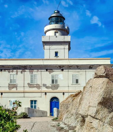
Capo Caccia Light, Porto Conte, April 2017
ex-Google Plus photo by Simone Manunta

Alghero and Porto Conte Area Lighthouses
Isolotto della Maddalena (Alghero)
Date unknown. Active; focal plane 10 m (33 ft); red flash every 5 s. 6 m (20 ft) round concrete tower with lantern and gallery. Tower painted red, lantern and gallery white. Trabas has a closeup photo by Capt. Peter, a sunset 2022 photo is available ,Marco Faini has a view from the sea, Marinas.com has aerial photos, and Google has a satellite view. Located on a rocky islet in the harbor of Alghero. Accessible only by boat; there's a distant view from shore. Site open, tower closed. EF-1415; Admiralty E1122; NGA 8284.
* [Porto Alghero]
1866. Inactive for many years. Approx. 13 m (43 ft) fort, the Bastioni della Maddalena. Jenkins 1904 light list has a "circular turret" atop the northwest corner of the bastion. Hagen Zirpel has a street view and Google has a satellite view. Located at the southern end of the Porto Alghero waterfront. Site open.
* Porto Conte (Torre Nuova) (2)
Date unknown (station established 1919). Active; focal plane 17 m (56 ft); white flash every 3 s. 8 m (26 ft) round concrete tower with lantern and gallery. Lighthouse painted white; lantern roof is gray metallic. Antonio Coti Zelati's 2023 photo is at right, the Navy has a page for the lighthouse, Trabas has a good photo by Eckhard Meyer, Wikimedia has a photo by Gianni Careddu, a 2007 closeup is available, Wikimedia has several photos, and Google has a street view and a satellite view. The original light was listed as an iron tower. The lighthouse stands in front of another historic Aragonese tower and a few feet from a large resort, the Hotel El Faro. Accessible by road; parking available. Located on a promontory projecting into the bay of Porto Conte just west of the town. Site open, tower closed. . EF-1422; Admiralty E1126; NGA 8280.
Capo Caccia
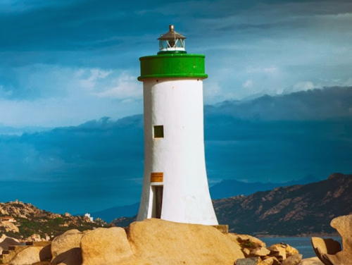
1864. Active; focal plane 186 m (610 ft); white flash every 5 s. 24 m (79 ft) round cylindrical masonry tower with lantern and gallery, rising from one corner of a 3-story masonry keeper's house. Entire lighthouse painted white. This is a staffed lighthouse. Simone Manunta's photo is at the top of this page, Trabas has a photo by Capt. Peter, the Navy has a page for the lighthouse, Robert Ferrari has a photo of the spectacular site, Wikimedia has distant views, Marinas.com has aerial photos, and Google has a satellite view. The building also carries a second lantern housing a reserve light. Located atop a vertical cliff at the extreme southern tip of the peninsula sheltering the harbor of Porto Conte. Site and tower closed. The lighthouse can be viewed from nearby, but approaching it requires a formidable hike up 654 steps. . ARLHS SAR-009; EF-1418; Admiralty E1124; NGA 8276.

Torre Nuova Light, Porto Conte, September 2023
Instagram photo by Antonio Coti Zelati

Golfo dell'Asinara Lighthouses
The Gulf of Asinara is an open bight at the northwestern corner of Sardinia, sheltered on the west by the island of Asinara.
Asinara (Capo Caprara, Punta Scorno, Porta della Scorno, Isola dell'Asinara)
1859. Active; focal plane 80 m (262 ft); four white flashes every 20 s. 35 m (115 ft) round masonry tower with lantern and gallery, rising from a 3-story keeper's house. Entire lighthouse painted white. Riccardo McRonk has the 2020 photo seen at right, the Navy has a page for the lighthouse, Guido Volpi has a nice view, Trabas has Ferrighi's distant view, Marinas.com has aerial photos, Paolo Cominetti has a closeup street view, and Google has a satellite view. Endangered: a large part of the east side of the keeper's house has actually collapsed. The Isola dell'Asinara is a rugged island off the northwestern tip of Sardinia. The island is named for a herd of wild albino donkeys that has lived there for centuries. Formerly used as a prison, the island is now a national park but is open only with special permission. Located at the northern tip of the island. Site and tower closed. Site manager: Parco Nazionale dell'Asinara. ARLHS SAR-023; EF-1426; Admiralty E1130; NGA 8212.
Cala Reale (Rada della Reale, Scogli Neri)
Date unknown (station established 1912). Active; focal plane 11 m (36 ft); flash every 5 s, white or red depending on direction. 11 m (36 ft) round cylindrical stone tower, painted white, mounted on a stone pier. Utzeri has two photos, Nino Mele has a photo, Trabas has Eckhard Meyer's distant view, and Google has a satellite view. Located on a shoal in the Rada della Reale, the bay sheltered by the Isola dell'Asinara, about 1.2 km (3/4 mi) south of La Reale. Accessible only by boat. Site open, tower closed. EF-1430; Admiralty E1132; NGA 8268.
* Stintino West Entrance
Date unknown. Active (privately maintained); focal plane about 7 m (23 ft); light characteristic unknown. 5 m (17 ft) hexagonal concrete skeletal tower with enclosed lower portion, painted with red and white horizontal bands. A 2008 closeup photo is available, Gian Pierro Faedda has a second closeup, Pino Trinchise has a 2021 photo, and Google has a street view and a satellite view. Located on the waterfront in Stintino, this light is not listed by NGA or the Admiralty. Site open, tower closed. Not listed by the Admiralty.
Stintino Secca
Date unknown. Active (privately maintained); focal plane 6 m (20 ft); white flash every 5 s. 6 m (20 ft) square pyramidal concrete tower, painted with black and white horizontal bands. Trabas has a photo by Capt. Peter and Google has a street view and a satellite view. Located on a shoal in the center of the entrance to the harbor at Stintino. Accessible only by boat, but easily viewed from shore. Site open, tower closed. EF-1432; Admiralty E1134; NGA 8264.

Asinara Light, Isola dell'Asinara, July 2020
Google Maps photo by Riccardo McRonk
Porto Torres Industrial Harbor Range Front
Date unknown. Active (privately maintained); focal plane 16 m (52 ft); red light, 1 s on, 1 s off. Approx. 13 m (43 ft) square skeletal tower painted red and carrying a daymark colored black with a white vertical stripe. Trabas has Capt. Peter's photo and Google has a satellite view and a distant street view. Located on the waterfront of the industral harbor on the east side of Porto Torres. Site and tower closed. Admiralty E1136.5; NGA 8250.
Porto Torres Industrial Harbor Range Rear
Date unknown. Active (privately maintained); focal plane 23 m (75 ft); red flash every 4 s. Approx. 19 m (62 ft) square skeletal tower painted red and carrying a daymark colored black with a white vertical stripe. Trabas has Capt. Peter's photo and Google has a satellite view. Located about 60 m (200 ft) south of the front light. Site and tower closed. Admiralty E1136.51; NGA 8250.1.
* Porto Torres (2)
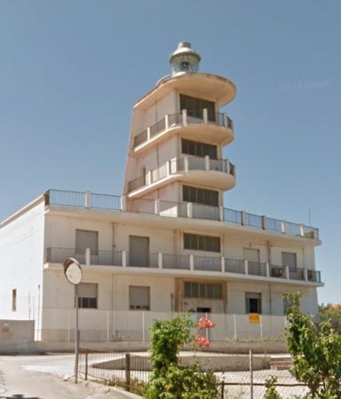
1966 (station established 1852). Active; focal plane 45 m (148 ft); two long (2 s) white flashes every 10 s. 20 m (66 ft) 4-story rectangular cylindrical cylindrical tower with lantern and three galleries rising from the center of a 1-story keeper's house. Lighthouse painted white; lantern dome is gray metallic. Google's 2017 street view is at right, Ferrighi has a photo, Utzeri has numerous photos, Trabas has Capt. Peter's closeup photo, a 2008 photo of the lighthouse in action is available, and Google has a satellite view. Porto Torres is an important ferry port with ferries arriving from Genoa, Marseille, Toulon, Barcelona, and Civitavecchia. This interesting modern lighthouse was built to give Porto Torres a light with much greater range than the historic tower. Located atop a hill (Monte Angellu) on the west side of the town, overlooking the harbor. Site and tower closed (military reservation), but the lighthouse can be viewed from nearby. ARLHS SAR-033; EF-1437; Admiralty E1138; NGA 8216.
** Porto Torres (1)
1852. Inactive since 1966. Approx. 20 m (66 ft) octagonal cylindrical masonry tower, unpainted. Lantern removed. Claudio Pisu has a 2016 photo, Carles Sanjuan has a 2017 photo, Mitja Zupan has a 2021 photo, and Google has a closeup street view and a good satellite view. This massive tower was built by the Kingdom of Aragon, which conquered Sardinia in a series of campaigns between 1323 and 1409, inaugurating three centuries of Spanish rule. Huelse has a postcard view of the tower crowned by a short lighthouse; although the lantern has been removed it appears that at least part of the stone base of the lighthouse survives atop the medieval construction. Located just behind the waterfront of Porto Torres (Port of the Towers), a port at the northwestern corner of Sardinia. Site open, tower status unknown, possibly open.
Porto Torres Molo di Ponente
Date unknown. Active; focal plane 11 m (36 ft: green light, 2 s on, 4 s off. 9 m (30 ft) bottle-style light mounted on a square 1-story equipment shelter. Entire lighthouse painted green. Trabas has Capt. Peter's photo and Google has a satellite view. Located at the end of the west breakwater of Porto Torres. Site and tower closed. EF-1454; Admiralty E1139; NGA 8224.
* Porto Torres Molo di Levante
Date unknown. Active; focal plane 11 m (36 ft: red light, 2 s on, 4 s off. 9 m (30 ft) bottle-style light mounted on a round 1-story stone tower. The stone is unpainted, light tower painted red. Trabas has Capt. Peter's photo, Urs Welti has a closeup street view, and Google has a satellite view. Located at the end of the east breakwater of Porto Torres. Accessible by walking or driving the pier. Site open, tower closed. EF-1456; Admiralty E1140; NGA 8220.

1966 Porto Torres Light, Porto Torres, July 2017
Google Maps street view

Strait of Bonifacio Lighthouses
The Strait of Bonifacio, only 11 km (7 mi) wide, separates French Corsica from Sardinia. Strewn with rocks and shoals, it is one of the most dangerous passages in the western Mediterranean. On the Italian side, at the eastern end of the strait, is a group of islands, the Arcipelago di la Maddalena.

* Capo Testa
1845 (modernized in 1955). Active; focal plane 67 m (220 ft); two white flashes every 12 s. 23 m (75 ft) square cylindrical masonry tower with lantern, round watch room, and two galleries, rising from a 2-story masonry keeper's house. Giangy Woow's 2024 photo is at right, Trabas has Arno Siering's photo, Matej Romih has a 2021 photo, Alexander Goldenberg contributed a photo, Wikipedia has an Italian page for the lighthouse with a photo by Roberto Ferrari, Utzeri has a portfolio of photos, Marinas.com has aerial photos, and Google has a street view and a satellite view. The original lighthouse was 45 m (148 ft) tall but had the same focal height as the present light. This handsome lighthouse stands on a steep headland on a promontory connected to the mainland by a narrow isthmus. It marks the northern tip of Sardinia and the western entrance to the Strait of Bonifacio. Located at the end of highway of highway SP90 about 7 km (4.5 mi) west of Santa Teresa Gallura. Accessible by road; parking is available but may be crowded. Site open, tower closed. . ARLHS SAR-021; EF-1014; Admiralty E0938; NGA 8208.
Longosardo (Longo Sardo, Santa Teresa Gallura, Punta Corvo)
Date unknown. Active; focal plane 11 m (36 ft); flash every 3 s, white or red depending on direction. 8 m (26 ft) square cylindrical tower with lantern and gallery. Lighthouse painted white with one red horizontal band; lantern dome is gray metallic. Trabas has Capt. Peter's closeup photo, Marco Napoleone has a 2017 photo, and Google has a satellite view. Located on the east side of the entrance to the harbor of Santa Teresa Gallura, the town at the northernmost tip of Sardinia. Accessible only by boat (the trail to the light begins in private property), but there should be a good view from ferries arriving from Bonifacio, Corsica. Site open, tower closed. ARLHS SAR-028; EF-1018; Admiralty E0936; NGA 8200.

Capo Testa Light, Santa Teresa Gallura, February 2024
Instagram photo by Giangy Woow

Maddalena Archipelago Lighthouses
The Maddalena Archipelago is a group of small islands in the Strait of Bonifacio between Corsica and northeastern Sardinia. Much of the archipelago is protected in a national park, the Parco Nazionale dell'Arcipelago di la Maddalena.

Razzoli (2)
1845. Inactive since 1969. 12 m (39 ft) 2-story masonry keeper's house with lantern and a square masonry watch room centered on the roof. Entire lighthouse painted white; lantern dome is gray metallic. Endangered. The lighthouse was abandoned when its deterioration made it seem unsafe and uneconomic to maintain. By 2000 the lighthouse was in very poor condition. In 2007 a European Commission grant funded a partial restoration of the building. Utzeri has a photo showing this work in progress, Massimo Portas has the photo of the two lighthouses seen at right, a 2023 photo is available, nd Google has a satellite view. Roberto Minunno has a street view, taken from atop the lighthouse, showing that much work remains to be done. The Isola di Razzoli is the northwestern end of the Arcipelago di la Maddalena; it is the island closest to Corsica. Located at the northwestern tip of the island. Accessible only by boat; ecotours to the island are available, and there is a pier on the west side of the island where boats can be moored. Site open, building probably open but dangerous. Site manager: Parco Nazionale dell'Arcipelago di la Maddalena. ARLHS SAR-006.
Razzoli (3)
1974. Active; focal plane 77 m (253 ft); flash every 2.5 s, white or red depending on direction. 12 m (39 ft) round rubblestone tower with lantern and gallery. The tower is unpainted gray stone; gallery is white, lantern dome gray metallic. Massimo Portas has the photo of the two lighthouses seen at right, a closeup is available, Trabas has Darlene Chisholm's photo, and Google has a satellite view. Located on the seaward side of the historic lighthouse. Site open, tower closed. Site manager: Parco Nazionale Arcipelago di la Maddalena. . EF-1000; Admiralty E0940; NGA 8196.

New and old Razzoli Lights, IIsola di Razzoli, July 2020
Google Maps photo by Massimo Portas
Santa Maria (Punta Filetto)
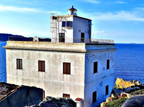
1913. Active; focal plane 17 m (56 ft); four white flashes every 20 s. 12 m (39 ft) 2-story masonry keeper's house with a lantern and a square masonry watch room centered on the roof. Entire lighthouse painted white; lantern dome is gray metallic. The Navy has a page for the lighthouse, a photo is at right, Trabas has Ferrighi's photo, Łukasz Monkiewicz has a 2014 street view, and Google has a satellite view. Benedictine monks at a nearby monastery (now in ruins) formerly kept fires burning to guide sailors through the strait. The lighthouse has been empty since it was automated in 1972, but the national park restored it in 2006-07. Scaffolding still surrounds the building in a 2009 photo at right, in a 2016 street view by Margherita Gaspardo Moro, and in Francesco D'Auria's 2021 photo seen at right. There are several private vacation homes on the Isola di Santa Maria, some of which can be rented in season. Located on the north point of the island, facing the strait; the location is only 1.4 km (0.9 mi) west of the Corcelli light. Accessible only by boat, but landing facilities are available. Site open, tower closed. Site manager: Parco Nazionale dell'Arcipelago di la Maddalena. ARLHS SAR-007; EF-1004; Admiralty E0942; NGA 8188.
Corcelli (Barrettinelli di Sopra) (3)
1961 (station established 1936). Active; focal plane 22 m (72 ft); two white flashes every 10 s. 12 m (39 ft) round stone tower with gallery, painted black with one red horizontal band. Lantern removed. The Navy has a page for the lighthouse, Trabas has Darlene Chisholm's closeup, Alessandro Bulgheroni has a 2021 closeup, and Google has a satellite view. The original lighthouse was destroyed during World War II and replaced by a skeletal tower. The present lighthouse was unpainted until fairly recently. Located on a dangerous rock off the northern point of the island of Corcelli and near the southeastern entrance to the strait, about 8 km (5 mi) north of La Maddalena. Accessible only by boat in rough seas. Site and tower closed. Site manager: Parco Nazionale dell'Arcipelago di la Maddalena. ARLHS SAR-026; EF-1010; Admiralty E0946; NGA 8192.

Santa Maria Light, Isola di Santa Maria, September 2021
Google Maps photo by Francesco D'Auria

Palau Area Lighthouses
The lights in this group guides vessels in the passage between the Maddalena Islands and the mainland of Sardinia.
* Punta Sardegna
1913. Active; focal plane 35 m (115 ft); white flash every 5 s. 13 m (43 ft) square cylindrical granite tower with lantern and gallery, rising from a 2-story granite keeper's house. Sometime in recent years the lantern was moved to the top of the building from the balcony behind the location of the flags in Roberta Spiga's photo at right. Entire lighthouse painted white; the lantern dome is gray metallic. A 2021 photo is at right, Wikimedia has Carlo Pelagalli's 2013 photo , the Navy has a page for the lighthouse, Utzeri has many photos, Trabas has Capt. Peter's photo, and Google has a satellite view. The Universities of Cagliari and of Trieste have restored the lighthouse as a research center for coastal and marine geology. The 100th anniversary of the station was celebrated in 2013. Located on a promontory about 8 km (5 mi) northwest of Palau. The access road is private but the entrance is not gated. Site open, tower closed. Site manager: Osservatorio Coste e Ambiente Naturale Sottomarino (OCEANS). . ARLHS SAR-036; EF-1030; Admiralty E0950; NGA 8836.
* Palau (Punta Palau, Punta Faro) (2)
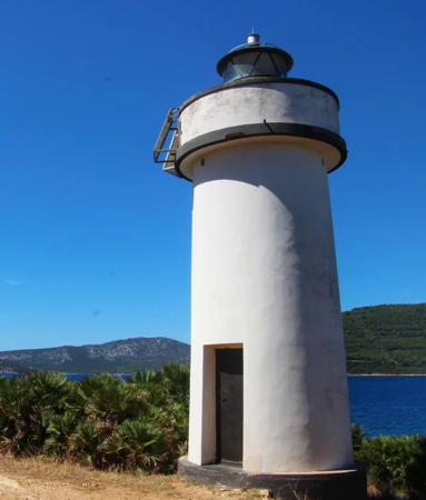
Date unknown (around 1960?). Active; focal plane 15 m (49 ft); two green flashes every 10 s. 10 m (33 ft) round tapered masonry tower with a small lantern and gallery. Lighthouse painted white with one green horizontal band around the gallery. Massimo Cioli has the 2022 photo at right, Andrea Labate has a photo, the Navy has a page for the lighthouse, Trabas has an excellent photo by Rainer Arndt, a good 2008 closeup is available, and Google has a street view and a satellite view. We need information on the history of this station; there was an earlier lighthouse here in the 1930s. Palau is the ferry terminal for ferries serving the Arcipelago di la Maddalena and the national park encompassing those islands. The lighthouse is located on rocks just off a promontory northwest of the harbor of Palau. Site open, tower closed. . ARLHS SAR-035; EF-1034; Admiralty E0988; NGA 8832.
Guardia Vecchia Range Front
Date unknown. Active; focal plane 50 m (164 ft); green light, 1 s on, 1 s off. 5 m (17 ft) square 1-story building, painted white with a black vertical stripe. The light is shown through a window. Trabas has Darlene Chisholm's photo, these range lights are near the right edge of a 2014 photo, and Google has a satellite view. The range guides vessels approaching La Maddalena, a port on the south side of the island of the same name. Located on a steep hillside northwest of the town. Site status unknown. EF-1045; Admiralty E0957; NGA 8768.
Guardia Vecchia Range Rear
Date unknown. Active; focal plane 150 m (492 ft); green light, 3 s on, 1 s off. 5 m (17 ft) square 1-story building, painted white with a black vertical stripe, perched on the wall in front of the Guardiavecchia weather and coast guard station. The daymark continues down the wall making the tower appear much taller than it is. The light is shown through a window. Trabas has Darlene Chisholm's photo, these range lights are near the right edge of a 2014 photo, and Google has a satellite view and a distant street view of the station. Located atop a steep hill 869 m (0.54 mi) north of the front light. Site status unknown. EF-1046; Admiralty E0957.1; NGA 8772.
Isola Chiesa (Maddalena Range Front)
Date unknown. Active; focal plane 17 m (56 ft); continuous green light. 4 m (13 ft) square 1-story concrete building, painted white with a black vertical stripe. Trabas has Capt. Peter's photo and Google has a satellite view. Chiesa is a small island protecting the harbor of La Maddalena, the largest town of the islands. Accessible only by boat. Site status unknown. EF-1080; Admiralty E0960; NGA 8760.
Forte Camicio (Maddalena Range Rear, Forte Carlo Felice)
Date unknown. Active; focal plane 37 m (121 ft); continuous green light. 7 m (23 ft) stone fortification; the light is mounted atop the wall above a daymark painted white with a black vertical stripe. Trabas has Capt. Peter's photo and Google has a satellite view. Located on a hill on the east side of La Maddalena. Site open, tower closed. EF-1100; Admiralty E0960.1; NGA 8761.


Punta Sardegna Light, Pulau, May 2021
Google Maps photo by MAX_LC8R


Palau Light, Palau, November 2022
Google Maps photo
by Massimo Cioli

Cala Stagnali Range Front
Date unknown. Active; focal plane 9 m (30 ft); continuous green light. 5 m (17 ft) square pyramidal stone tower, painted white with a black vertical stripe. Since vegetation obscures the daymark, the light has been raised on a mast attached to the tower. Trabas has Capt. Peter's photo and Google has an indistinct satellite view. Stagnali is a small port on the southwest side of the Isola Caprara. Located at the water's edge about 150 m (500 ft) west of the port. Site open, tower closed. EF-1137; Admiralty E0997; NGA 8816.
Cala Stagnali Range Rear
Date unknown. Active; focal plane 14 m (46 ft); continuous green light. 5 m (17 ft) square pyramidal stone tower, painted white with a black vertical stripe. Since vegetation obscures the daymark, the light has been raised on a mast attached to the tower. Trabas has Capt. Peter's photo and Google has an indistinct satellite view. Located at the west edge of Stagnali, 87 m (285 ft) southeast of the front light. Site open, tower closed. EF-1137.1; Admiralty E0997.1; NGA 8820.
Capo d'Orso (1)
1924. Inactive since 1960. 2-story masonry keeper's house. It's not clear how the light was displayed; we need a historic image. Marian Soave's photo is at right and Google has a satellite view. The house is abandoned and in poor condition. Owner: Sardinia Regional Government.
Capo d'Orso (2)
1960 (station established 1924). Active; focal plane 12 m (39 ft); green flash every 3 s. 10 m (33 ft) round tapered masonry tower with a small lantern and gallery. Lighthouse painted white. Marian Soave's photo is at right, Fabio Giuseppe Tedesco has a 2019 photo, Trabas has a closeup photo by Capt. Peter, and Google has a satellite view. The cape is named for a curious rock formation resembling a bear (orso). Note: there is another Capo d'Orso ("Cape Bear") lighthouse near Salerno (see the Campania page). Located on the point of the cape about 4 km (2.5 mi) east of Palau. Accessible only by boat or by a tough scramble through heavy vegetation and steep slopes. Site may be open but difficult to reach, tower closed. ARLHS SAR-043; EF-1125; Admiralty E0992; NGA 8748.

Old and new Capo d'Orso Lights, Palau, July 2017
ex-Google Plus photo by Marian Soave

Porto Cervo Area Lighthouses
Isolotti Monaci
Date unknown. Active; focal plane 24 m (79 ft); flash every 5 s, white or red depending on direction. 16 m (52 ft) round masonry tower with lantern and gallery, painted white according to NGA and the Navy's photos, but other photos show the tower to be white with remains, at least, of a red horizontal band. Trabas has Capt. Peter's closeup photo and Bing has a satellite view. The Isolotti Monaci are a group of dangerous rocks about 2.5 km (1.5 mi) east of the Isola di Caprera and 8 km (5 mi) north of Capo Ferro. Located atop the largest rock. Accessible only by boat. Site open, tower closed. ARLHS SAR-005; EF-1142; Admiralty E0998; NGA 8736.
Isola delle Bisce
Date unknown. Active; focal plane 12 m (39 ft); green flash every 3 s. 10 m (33 ft) round tapered masonry tower with a small lantern and gallery. Lighthouse painted white with one green horizontal band around the gallery and a second green horizontal band around the base of the tower. Trabas has a photo by Ferrighi, Marinas.com has aerial photos, and Google has a satellite view. This little lighthouse and the next one below guide ships through the narrow Bisce Channel (Canale della Bisce) between Capo Ferro and the Isola della Bisce. Located on the south shore of the Isola della Bisce. Accessible only by boat. Site open, tower closed. ARLHS SAR-002; EF-1148; Admiralty E1000; NGA 8732.
Canale delle Bisce (Capo Ferro Northeast)
Date unknown. Active; focal plane 14 m (46 ft); red flash every 3 s. 10 m (33 ft) round masonry tower with a small lantern and gallery. Lighthouse painted white with one red horizontal band around the gallery. The Navy has a page for the lighthouse, Trabas has Ferrighi's photo, a 2021 closeup is available, Anthony Piredda has a 2019 photo (also showing the Capo Ferro lighthouse), Marinas.com has aerial photos, Mirko Jeckstadt has a street view, and Bing has a satellite view. This light is on the south side of the Canale della Bisce, which is only about 500 m (1/3 mi) wide. Located on the point of Capo Ferro, 320 m (350 yd) northeast of the main lighthouse. The site appears to be accessible only by boat, although there are views from nearby. Site and tower closed. . ARLHS SAR-014; EF-1147; Admiralty E1003; NGA 8728.
Capo Ferro (Capo del Faro)
1861. Active; focal plane 52 m (171 ft); three white flashes every 15 s. 16 m (52 ft) round masonry tower with lantern and gallery, rising from the seaward side of a 2-story keeper's house. Entire lighthouse painted white; lantern dome is gray metallic. Konrad Warszawski has a 2022 photo (seen at right), the Navy has a page for the lighthouse, Trabas has an excellent photo by Arno Siering, Alessandro Idili Patrizia Chironi has a 2007 photo, Marinas.com has aerial photos, and Google has a street view and a satellite view. Capo Ferro is at the northeastern corner of Sardinia, in the heart of the beautiful coast called the Costa Smeralda (Emerald Coast). Located above the point of the cape, about 8 km (5 mi) northwest of Porto Cervo. Accessible by road. Site and tower closed (naval installation). ARLHS SAR-015; EF-1146; Admiralty E1002; NGA 8724.

Capo Ferro Light, Porto Cervo, October 2022
Google Maps photo by Konrad Warszawski

Olbia Area Lighthouses
Olbia is a city of 60,000 residents located at the head of a narrow inlet on Sardinia's northeast coast. It is the busiest ferry terminal for Sardinia, with service from Genoa, Livorno, Piombino and Civitavecchia on the Italian mainland.
Isolotto Figarolo (Figarello)
Date unknown (station established 1915). Active; focal plane 71 m (233 ft); white flash every 5 s. 6 m (20 ft) square cylindrical masonry tower with lantern and gallery, covered with tiles colored white with one black horizontal band. Trabas has Ferrighi's view from the sea, Ferdinando Mei has a very distant view, and Google has a satellite view. Figarolo is a small, steeply mountainous island on the north side of the entrance to the Golfo di Olbia and the east side of the entrance to the smaller Golfo di Aranci. Accessible only by boat. Site status unknown. ARLHS SAR-027; EF-1162; Admiralty E1010; NGA 8664.
Isola della Bocca (Olbia)
1887. Active; focal plane 24 m (82 ft); white light, 2 s on, 3 s off. 22 m (72 ft) square cylindrical masonry tower with lantern and gallery, attached to the seaward side of a 2-story masonry keeper's house. Entire lighthouse painted white; lantern dome is gray metallic. Gianni Careddu's photo is at right, Ferrighi has a photo, Trabas has Capt. Peter's closeup photo, Marinas.com has aerial photos, and Google has a satellite view and a distant street view. Located on a small island at the mouth (bocca) of the estuary forming the Porto di Olbia. Accessible only by boat, but there are excellent views from the south shore of the estuary at Lido del Sole, 400 m (1/4 mi) away. Site and tower closed. . ARLHS SAR-024; EF-1170; Admiralty E1014; NGA 8616.
Tavolara (Isola di Tavolara, Punta Timone) (2)
1920 (station established 1861). Active; focal plane 72 m (236 ft); two long (2 s) white flashes every 10 s. 7 m (23 ft) octagonal unpainted concrete tower with lantern and gallery. Trabas has Capt. Peter's closeup photo and Google has a satellite view. The Isola di Tavolara is a spectacular mountainous island off the southern entrance to the Golfo di Olbia. The island, formerly a penal colony, is now an upscale resort accessible by passenger ferry from Porto San Paolo. Located on Punta Timone at the extreme northeastern tip of the Isola di Tavolara. Access to this location would be very difficult. Site status unknown. ARLHS SAR-037; EF-1226; Admiralty E1028; NGA 8600.
Tavolara (Isola di Tavolara) (1)
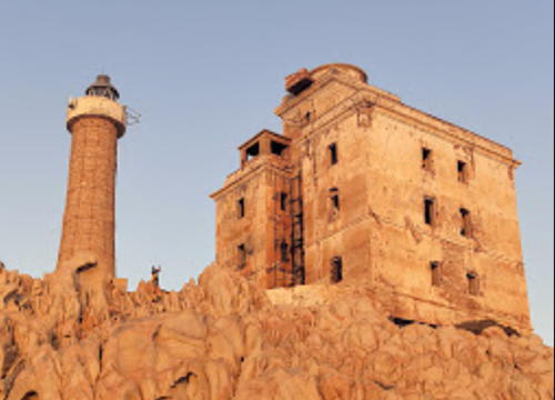
1861. Inactive since 1920. Approx. 9 m (30 ft) square cylindrical stone tower, attached to one corner of a 2-story stone keeper's house. Lantern removed, and the lighthouse is unroofed and in ruins. A photo by Capt. Peter is at right, Wikimapia also has photos of the ruins and Google has a satellite view. This lighthouse, built by prisoners, had a focal plane height of 164 m (538 ft) and was too high on a precipitous slope to be easily maintained. Located high above the eastern end of the island, about 1.5 km (1 mi) south of Punta Timone; possibly accessible by hiking trails. Site open, tower closed.

Information available on lost lighthouses:

Notable faux lighthouses:

  • Capo Figari, Golfo Aranci area, northeast coast. Often listed as a historic lighthouse, this building was a signal station. There is no evidence that it ever carried a light. Andrea Caramanna has a closeup street view and Google has a satellite view of the station. In 2023 area residents were fighting plans to develop the property as a luxury hotel.
  • Punta Falcone, Santa Teresa di Gallura area. Wikimedia has a photo of this former signal station labeled as an "old lighthouse," but it was never an aid to navigation. Google has a satellite view of the station.


Isola della Bocca Light, Olbia, June 2016
Wikimedia Creative Commons photo by Gianni Careddu


1861 Isola di Tavolara Light, Olbia, September 2021
photo copyright Capt. Peter Mosselberger; used by permission
Adjoining pages: North: Corsica | South: Central and Southern Sardinia

Return to the Lighthouse Directory index | Ratings key

Posted May 24, 2006. Checked and revised March 31, 2024. Lighthouses: 38. Site copyright 2024 Russ Rowlett and the University of North Carolina at Chapel Hill.