Lighthouses of Singapore

The Republic of Singapore is an independent city-state located on an island off the tip of the Malay Peninsula. The city faces the Singapore Strait, the shortest route connecting the Indian and Pacific Oceans, giving the city one of the world's most strategic locations. Singapore was founded as a British outpost in 1819 by Sir Thomas Stamford Raffles and for 140 years it was the keystone of the British Empire in the Orient. From 1858 until Japan occupied Singapore in 1942 the island was part of the Straits Settlements, a crown colony that also included several British territories in Malaya. After Japan's defeat in 1945 Singapore became a separate crown colony. In 1963 it joined with Malaya, Sabah, and Sarawak in the Federation of Malaysia. Tensions between the city's urban population and the population of the rest of the federation proved to be too great, so in 1965 Singapore left the federation to become independent.

English is an official language in Singapore, along with Chinese (Mandarin), Malay, and Tamil. English is the language of government and commerce but geographic names are often in Malay; in that language pulau is an island, batu is a rock, tanjung is a cape, bukit is a hill, sungai is a river, kuala is the mouth of a river, teluk is a bay, selat is a strait, and pelabuhan is a harbor.

Aids to navigation in the heavily-traveled Singapore and Malacca Straits are regulated by the Malacca Strait Council, a consortium of the maritime authorities of Singapore, Malaysia, and Indonesia. Singapore's aids to navigation are operated and maintained by the Maritime and Port Authority of Singapore (MPA).

ARLHS numbers are from the ARLHS World List of Lights. Admiralty numbers are from volume F of the Admiralty List of Lights & Fog Signals. U.S. NGA List numbers are from Publication 112.

General Sources
Lighthouses in Singapore
Information available from Wikipedia.
Lighthouses in Singapore
Photos available from Wikimedia (including the photos illustrating the Wikipedia articles).
Singapore Infopedia
This electronic reference is maintained by the National Library of Singapore. Search for "lighthouse" to locate articles on each light.
Online List of Lights - Singapore
Photos by various photographers posted by Alexander Trabas.
World of Lighthouses - Singapore
Photos by various photographers available from Lightphotos.net.
Other Regions of the World
Historic postcard views posted by Michel Forand.
Leuchttürme Asiens auf historischen Postkarten
Historic postcard views posted by Klaus Huelse.
GPSNauticalCharts
Navigation chart for Singapore.
Navionics Charts
Navigation chart for Singapore.

Horsburgh Light, Singapore Strait, October 2021
Google Maps photo by Ismanizar Mohd Ali
Lighthouses
Horsburgh (Pulau Batu Puteh, Pedra Blanca)
1851 (John Turnbull Thomson). Active; focal plane 31 m (102 ft); white flash every 10 s. 34 m (112 ft) round granite tower with lantern and gallery, attached to a 2-story concrete keeper's complex. Lighthouse painted with black and white horizontal bands. Ismanizar Mohd Ali's 2021 photo is above, MPA has a 2006 photo, Trabas has a good photo by Capt. Theo Hinrichs, Lightphotos.net has a 2012 photo, Daniel Koh has a view from the sea, and Google has a somewhat indistinct satellite view. This lighthouse, Singapore's oldest, was named for James Horsburgh (1762-1836), the hydrographer of the East India Company who charted the seaways around Singapore. Following his death in 1836 British merchants in China quickly proposed that a memorial lighthouse be built at the Straits, but a decade passed before the site was selected and construction was authorized. The lighthouse stands on a notorious rock outcrop, long called Pedra Blanca ("white rock," batu puteh in Malay) by European navigators. The islet is about 40 km (25 mi) east of any other Singapore territory. In the late 1900s Malaysia maintained a claim to Pulau Batu Puteh on the grounds that the islet was historically under the control of the Sultan of Johor (Johor is now a state of Malaysia). Malaysia did not object to Singapore's continued operation of the lighthouse but sought sovereignty over the island. In 2003 Malaysia and Singapore agreed to refer their territorial dispute to the International Court of Justice at The Hague, Netherlands. The case was argued in November 2007 and in May 2008 the court ruled in favor of Singapore. Located off the eastern entrance to the Singapore Strait. Accessible only by boat. Site and tower closed. . ARLHS SIN-001; Admiralty F1820; NGA 21188.
Changi Naval Base
Date unknown. Active; focal plane 13 m (43 ft); three white flashes every 15s. 13 m (43 ft) round white tower on a square platform supported by piles. No photo available but Google has a satellite view. The Changi Naval Base is built on filled land at the eastern tip of Singapore Island; it is the home port of the Singapore Navy, which operates three frigates and several submarines. Located just off the east side of the naval base. Site and tower closed. Admiralty F1735; NGA 21200.3.
Changi Naval Base East Breakwater
Date unknown. Active (?); focal plane about 18 m (59 ft); white light, pattern unknown. Approx. 15 m (49 ft) round tower. No photo available but Google has a satellite view. Navionics charts a white light at this location. Located on the east breakwater of the base. Site and tower closed. Not listed by the Admiralty.
Changi Naval Base South Breakwater
Date unknown. Active; focal plane 12 m (39 ft); continuous light, white, red or green depending on direction. Approx. 10 m (33 ft) square skeletal tower. No photo available but Google has a satellite view. This is a leading light guiding ships into the naval base. Site and tower closed. Admiralty F1735.6; NGA 21200.4.
* Bedok
1978. Active; focal plane 76 m (249 ft); white flash every 5 s. "Red cubicle" atop a 26-story condo tower. another photo is available and Google has a street view and a satellite view (the building is centered in the image). Located at Lagoon View Block 5000L on Marine Parade Road in Bedok, a neighborhood on the east side of Singapore. Site open, tower closed. Admiralty F1733; NGA 21260.
** Amber Beacon
Date unknown. Active; focal plane 18 m (59 ft); yellow flash every 2.5 s. 15 m (49 ft) slender round concrete tower with a gallery and a large observation gallery halfway up the tower. A stairway spirals around the tower to reach the observation gallery. Lighthouse painted yellow. Dean Liaw has a 2022 photo, a 2017 closeup photo is available and Google has an indistinct satellite view and a street view from the East Coast Park bike trail. Brandon Ong has a street view taken on the observation gallery. Located on the beach in East Coast Park. Site and observation gallery open. . Admiralty F1732.5; NGA 21268.
* Fort Canning (Singapore) (2) (replica)
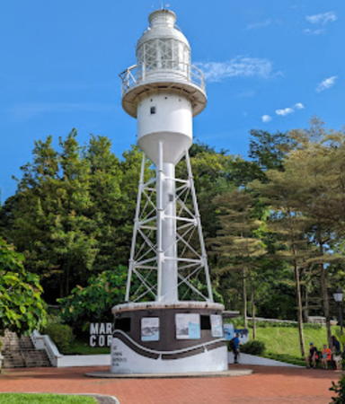
Replica of 1903 lighthouse (station established 1855). Station inactive since 1958 but the replica displays a decorative light. 24 m (80 ft) square steel skeletal tower with first-order lantern and gallery, painted white. Jo Lee's 2023 photo is at right, Wikimedia has Aldwin Teo's 2007 photo, Lightphotos.net has a 2011 photo, Desmond Koh has a 2021 closeup, Alain Guyomard and Robert Carceller have a photo by Didier dos Santos, Paul Gill has a fine 2006 photo, Forand has a historic photo, and Google has a street view and a satellite view. The lighthouse was built in Fort Canning, on Government Hill behind the harbor of Singapore. In 1958 the light was moved to the top of the Fullerton Building (see below) and in 1978 it was moved again, becoming the Bedok Light (see above). The historic lighthouse was disassembled after being deactivated. At some later time the replica was built for display not far from the original location in what is now Fort Canning Park. The decorative light was added in 2014. Site open, tower closed. . ARLHS SIN-007.

Fort Canning Light, July 2023
Google Maps photo by Jo Lee
* [Kusu Island (Turtle Island)]
Date unknown. Active; focal plane 6 m (20 ft); red flash every 2.5 s. 4 m (13 ft) conical red fiberglass tower. Trabas has Rainer Arndt's photo and Google has a satellite view. This minor light is in a lovely park at the east end of Kusu Island, site of a tortoise sanctuary and several temples and shrines. Accessible by passenger ferry from the Marina South Pier. Site open, tower closed. Admiralty F1699; NGA 21340.
Pulau Sakijang Pelepah (Lazarus Island)
Date unknown. Active; focal plane 59 m (194 ft); white flash every 2.5 s. 11 m (36 ft) wood skeletal tower painted black. Trabas has Rainer Arndt's distant view and Google has an indistinct satellite view. Located on an island off downtown Singapore, southeast of Sentosa. Site and tower closed. ARLHS SIN-003; Admiralty F1698; NGA 21336.
[Sentosa]
Date unknown. Active; focal plane 7 m (23 ft); red flash every 2 s. 7 m (23 ft) post mounted on a square platform supported by piles. Entire lighthouse painted red. A good photo is available, Trabas has Rainer Arndt's view, and Google has a satellite view. Located just off the southern point of Sentosa Island, a resort island in downtown Singapore. Accessible only by boat but easy to see from the shore. Site open, tower closed. Admiralty F1720.4; NGA 21355.4.
* Fullerton (lantern)
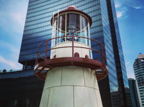
1958. Inactive since 1978 (a decorative light is displayed). Round lantern with aerobeacon, originally mounted atop the Fullerton Building in downtown Singapore; the building was then the General Post Office and is now the Fullerton Hotel. The lantern was formerly on display on the grounds of the former Singapore Maritime Museum (closed since 2001) on Sentosa Island. It was then moved to a location in front of Merrill Lynch Harbourfront in the Harbourfront development on the downtown waterfront. A 2008 photo is available, Lightphotos.net has Yuri Ishutin's photo, and Wikimedia has a 2011 photo. In 2018 Chance Brothers restored the lantern and relocated it again, this time to Mapletree Business City. Steven Lim has the photo at right and Google has a street view and a satellite view. Site open, tower closed.

Fullerton Light, May 2018
Google Maps photo by Steven Lim
* Berlayer Point (Labrador Park)
Date unknown. Inactive since 2005. 7 m (23 ft) robust square pyramidal concrete skeletal tower with lantern and gallery. Entire structure painted red. A closeup photo and a view from the harbor are available, Lightphotos.net has a closeup photo, a 2022 closeup is also available, and Google has a street view and a satellite view. Located in Labrador Park, on the north side of the west entrance to Keppel Harbour in downtown Singapore. Site open, tower closed. . ex-Admiralty F1702; ex-NGA 21388.
Cyrene Reef
Date unknown. Active; focal plane 8 m (26 ft); red flash every 2.5 s. 8 m (26 ft) square red concrete skeletal tower. Trabas has Rainer Arndt's photo and Google has an indistinct satellite view. Located at the east end of a large shoal area on the north side of the Sinki Strait, an inshore channel off the west waterfront of Singapore. Accessible only by boat. Site open, tower closed. Admiralty F1688; NGA 21576.
Selat Sinki
Date unknown. Active; focal plane 8 m (26 ft); three green flashes every 15 s. 8 m (26 ft) square green concrete skeletal tower. No photo available but Google has a fuzzy satellite view. Located on a shoal on the south side of the Sinki Strait. Accessible only by boat. Site open, tower closed. Admiralty F1686; NGA 21628.
** Raffles
1855 (John Bennet). Active; focal plane 32 m (105 ft); three white flashes every 20 s. 29 m (95 ft) round granite tower with lantern and gallery, attached to a 2-story keeper's house. Entire lighthouse painted white. This is a staffed station, with keepers serving 10-day shifts. S.J. Lim's 2024 photo is at right, Lighthouse Digest has an MPA photo, a 2022 photo and a 2008 photo are available, Jack Lim has a good 2015 photo, Lightphotos.net has a photo, Trabas has a photo by Capt. Theo Hinrichs, a distant photo shows the tall communication towers near the lighthouse, Huelse has a historic postcard view, Forand has a historic photo, and Google has a satellite view. This famous lighthouse is named for Sir Thomas Stamford Raffles (1781-1826), who founded the city of Singapore in 1819. It marks a sharp turn to the northwest for westbound ships in the Singapore Strait. In 2023 MPA experimented with powering the lighthouse by tidal energy. Located on Pulau Satumu (formerly called Coney Island), the southernmost islet of Singapore, about 14 km (9 mi) southwest of the downtown waterfront. In February 2022 MPA began offering guided tours to the lighthouse (reservations required). Site and tower closed except for guided tours on the second and fourth Saturdays of every month. . ARLHS SIN-004; Admiralty F1693; NGA 21500.


Tour group leaving Raffles Light, May 2024
Instagram photo by S.J. Lim

Pulau Satamu Semiphore
Date unknown. Active; focal plane 41 m (135 ft); white light, 5 s on, 5 s off. 40 m (131 ft) square skeletal tower carrying traffic signals on large panels. Trabas has a photo by Capt. Theo Hinrichs and Google has an indistinct satellite view. Located on the north point of Pulau Satamu, just north of the historic lighthouse. Site and tower closed. Admiralty F1693.2; NGA 21504.
Sultan Shoal
1896. Active; focal plane 20 m (66 ft); two white flashes every 15 s. 18 m (59 ft) round masonry tower centered on the roof of a 2-story keeper's house. Lighthouse painted white; keeper's house roof is red. A photo appears at right, Lighthouse Digest has an MPA photo, Lightphotos.net has a photo, Loh Kok Sheng has a 2008 photo, Kok Wheeler has a closeup photo, and Google has a satellite view. This striking lighthouse exhibits a remarkable mixture of Oriental and Victorian design. It was built to mark the western entrance to the Singapore Strait but it has lost most of its navigational purpose as it is nearly surrounded now by reclaimed land. Located off the southwest end of Singapore Island. Accessible only by boat, and there is an exclusion zone surrounding the lighthouse. Site and tower closed. . ARLHS SIN-005; Admiralty F1684; NGA 21656.
* Johor (Johore) Strait (Raffles Marina)
Date unknown. Active; focal plane 15 m (49 ft); white flash every 10 s. 12 m (39 ft) round cylindrical concrete tower with lantern and gallery, painted white. The navigation light is mounted atop the lantern. Yoshiaki Uno has a 2022 photo, Jonathan Hiew has a 2014 closeup photo, Reio Kimura has a 2017 street view, a 2021 sunset photo is available, and Google has an indistinct satellite view. This lighthouse marks the western entrance to the Johor Strait, which separates Singapore from the Malaysian mainland. Located at the end of a jetty at the Raffles Marina in Tuas, just west of the Second Link Expressway bridge over the strait. Accessible by walking the pier. Site open, tower closed. Site manager: Raffles Marina. . ARLHS SIN-006; Admiralty F1681; NGA 21685.

Information available on lost lighthouses:

Notable faux lighthouses:

Sultan Shoal Light
Sultan Shoal Light, December 2006
Wikimedia Creative Commons photo by LionFlyer

Adjoining pages: North: Southeast West Malaysia | South: Riau Islands | West: West Malaysia South Coast

Return to the Lighthouse Directory index | Ratings key

Posted March 5, 2006. Checked and revised May 12, 2024. Lighthouses: 16. Site copyright 2024 Russ Rowlett and the University of North Carolina at Chapel Hill.