Lighthouses of Indonesia: Karimun and Batam, Riau Islands

The Republic of Indonesia has been independent since 1945 after having been the Dutch East Indies for more than 350 years. It is a huge country, stretching along both sides of the Equator for more than 46 degrees of longitude (roughly 5100 km or 3200 miles). Comprised of some 17,000 islands (more than 6000 inhabited islands), it has hundreds of major aids to navigation.

Indonesia is divided into 38 provinces (provinsi) and the provinces are subdivided into county units called regencies (kabupaten). The Riau Islands Province includes four groups of small islands located between Sumatra and Kalimantan (Borneo). Formerly considered to be a southern extension of the South China Sea, these waters are now known as the Natuna Sea. The Riau group is south of Singapore and off the east coast of Sumatra; the Lingga group is farther south, straddling the Equator in the Karimata Strait; the Anambas group is off the east coast of West Malaysia; and the Natuna group is also in the Natuna Sea northwest of Sarawak in East Malaysia. In all there are more than 3000 islands in the province. This page includes lighthouses of the northwestern part of the province including the Karimun regency and Batam city. Other pages for the province cover Bintan and Lingga and Anambas and Natuna.

More than 700 languages are spoken in Indonesia. The official national language, Indonesian (Bahasa Indonesia), was standardized from a form of Malay that served as a lingua franca across the archipelago. In Indonesian a lighthouse is a mercusuar or a menara suar. Tanjung is a cape, ujung is a headland or point of land, bukit is a hill, sungai is a river, kuala or muara is an estuary or river mouth, pulau is an island, karang is a reef, batu is a rock, laut is a sea, selat is a strait, teluk is a bay, pelabuhan is a harbor, and labuhan is a port.

Aids to navigation in Indonesia are operated and maintained by the Directorate of Marine Navigation within the Directorate General of Sea Transportation.

ARLHS numbers are from the ARLHS World List of Lights. Admiralty numbers are from volume F of the Admiralty List of Lights & Fog Signals. U.S. NGA List numbers are from Publication 112.

General Sources
Online List of Lights - Indonesia
Photos by various photographers posted by Alexander Trabas. Many photos for the Singapore area are by Capt. Theo Hinrichs ("Capt. Theo").
World of Lighthouses - Indonesia
Photos by various photographers available from Lightphotos.net.
Indonesia
Historic postcard views from the collection of Michel Forand.
Riau Islands
A useful map showing the regency boundaries.
GPSNavigationCharts
Navigation chart information for the Riau Islands.
Navionics Charts
Navigation chart for the Riau Islands.
 

Takong Kecil Light, Singapore Strait, undated
Small Islands Directorate photo (no longer online)

Karimun Regency (Western Riau Islands) Lighthouses

Across the Singapore Strait from Singapore the Riau Islands proper are a loose group lying off the east coast of Sumatra. The islands are divided into three groups: Karimun in the west, Batam in the center, and Bintan in the east. The Durian Strait separates Karimun from Batam, and the Riau Strait separates Batam from Bintan.

Malacca Strait Lighthouses
Pulau Iyu Kecil (The Brothers) (2)
Date unknown (station established 1906). Active; focal plane 41 m (135 ft); three white flashes every 15 s. 13 m (43 ft) round concrete tower with lantern and gallery. Lighthouse painted white. Trabas has Capt. Theo's photo, seen at right, Wikimapia has a photo by Max von Schtirlitz, Suhaimi Simbolon has a closeup, a view from the sea and another view from the sea are available, Lightphotos.net also has a view from the sea, and Google has a satellite view. NGA lists a skeletal tower at this location. The Brothers are two small islands (Iyu Kecil and Iyu Besar) at the southern end of the Malacca Strait. Vessels eastbound in the Malacca Strait pass between this important light and Malaysia's Tanjung Piai Light shortly before turning into the Singapore Strait. Located on an island at the western entrance to the Singapore Strait, about 8 km (5 mi) north of the northern tip of Pulau Karimun. Accessible only by boat. Site status unknown. ARLHS IDO-072; Admiralty F1674; NGA 22584.
Pulau Karimun Kecil (Little Karimun Island)
2007. Active; focal plane 18 m (59 ft); white flash every 5 s. 15 m (49 ft) square pyramidal white skeletal tower. Trabas has Capt. Theo's photo, Fadlyllah Uman has a closeup photo and a view from the sea, and Google has a satellite view. Located on the northern tip of Little Karimun, about 5 km (3 mi) southeast of The Brothers. Accessible only by boat. Site status unknown. Admiralty F1674.05; NGA 22581.
 

Iyu Kecil (The Brothers) Light, Singapore Strait
photo copyright Capt. Theo Hinrichs; used by permission
 

Pulau Karimun Besar and Pulau Kundur Area Lighthouses
The Durian Strait (Selat Durian) is a north-south passage through the Riau Islands beginning at the western end of the Singapore Strait. Pulau Karimun Besar (Great Karimun) and Pulau Kundur are large islands west of the Durian Strait, separated from the mainland of Sumatra by another strait.
Sebatak Shoal
Date unknown. Active; focal plane 12 m (39 ft); two white flashes every 5 s. 12 m (39 ft) round fiberglass tower colored black with a red horizontal band and mounted on a platform supported by piles. No photo available and the light is not seen in Google's satellite view. This light is listed by the Admiralty as "Karimun River" and by NGA as "Tangjung Sebatak Southeast." Located on a shoal in the northern entrance to the Durian Strait from the Singapore Strait, east of Pulau Karimun Besar. Accessible only by boat. Site status unknown. Admiralty F1417.6; NGA 22587.
Tanjung Rambut
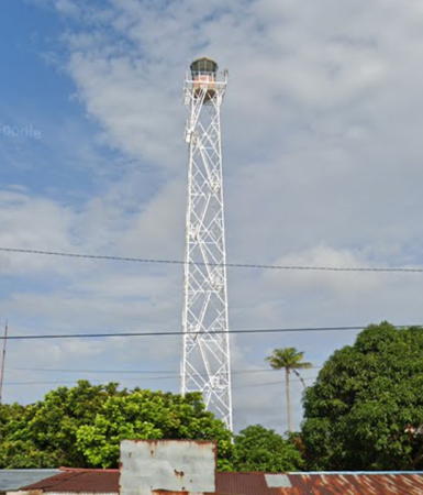
Date unknown. Active; focal plane 41 m (135 ft); three white flashes every 22 s. 40 m (131 ft) square skeletal tower with lantern and gallery, painted white; lantern painted red. A portion of Hendra Gunawan's aerial photo is at right and Google has a street view and a satellite view. This lighthouse is located near the city of Tanjung Balai on Great Karimun (Karimun Besar). The tower is part of a Maritime Security Agency (Badan Keamanan Laut) station monitoring ship traffic in the area. Located on the southeastern tip of the island; there should be a good view from fast ferries connecting Tanjung Balai with Singapore. Site status unknown. ARLHS IDO-323; Admiralty F1417.5; NGA 22588.
Pulau Babi
Date unknown. Active; focal plane 14 m (46 ft); white flash every 5 s. 14 m (46 ft) white tower mounted on a platform supported by piles. No photo available but Google has a satellite view. Located off the southern tip of an island at the west end of the narrow passage between Pulau Karimun Besar and Pulau Kundur. Accessible only by boat. Site open, tower closed. Admiralty F1417.3; NGA 22585.5.
Karang Tengah (Middleburg Reef) (1 and 2)
Date unknown. Active; focal plane 11 m (36 ft); white light, 2 s on, 6 s off. 11 m (36 ft) square pyramidal white skeletal tower mounted on a square platform supported by piles. No photo available but Google's satellite view shows two towers; the light is probably on the northern tower. Located on a reef on the west side of the Durian Strait southeast of Pulau Karimun Besar. Accessible only by boat. Site open, tower closed. Admiralty F1420; NGA 22600.
Karang Melvill (Melvill Reef)
Date unknown. Active; focal plane 11 m (36 ft); white flash every 5 s. 11 m (36 ft) square pyramidal white skeletal tower mounted on a square platform supported by piles. No photo available but Google has a satellite view. Located on a reef on the east side of the strait opposite Karang Tengah and near Pulau Mantaras Besar. Accessible only by boat. Site open, tower closed. Admiralty F1418; NGA 22596.

Tanjung Rambut Light, Tanjungbalai, November 2017
ex-Google Plus photo by Hendra Gunawan
Pulau Pelangkat
Date unknown. Active; focal plane 13 m (43 ft); white light, 2 s on, 6 s off. 13 m (43 ft) square pyramidal white skeletal tower mounted on a square platform supported by piles. No photo available but Google has a satellite view. Located on a reef on the west side of the Durian Strait just off the small island of Pulau Pelangkat. Accessible only by boat. Site open, tower closed. Admiralty F1422; NGA 22608.
Karang Genting
Date unknown. Active; focal plane 15 m (49 ft); white flash every 4 s. 15 m (49 ft) tower, probably skeletal, mounted on a square platform supported by piles. No photo available and the light is only a fuzzy spot in Bing's satellite view. Located on a reef on the east side of the Durian Strait south of the island of Pulau Durian. Accessible only by boat. Site open, tower closed. Admiralty F1424; NGA 22609.
 
Tanjung Lubuh (Lubuk)
Date unknown. Active; focal plane 35 m (115 ft); white flash every 8 s. Approx. 30 m (98 ft) square skeletal tower with gallery. Photos (near the bottom of the page) are available, although the caption bekas mercusuar means "former lighthouse." One of the photos is seen at right. Bing has a distant satellite view. Located on the southwestern tip of Pulau Kundur. Site open, tower closed. Admiralty F1417.2; NGA 22602.

Rukan Islands Lighthouse
The Rukan (Brother) Islands are three small islands in the Natuna Sea south of the southern entrance to the Durian Strait.

Rukan Utara (North Brother Island)
Date unknown. Active; focal plane 30 m (98 ft); white flash every 4 s. 13 m (43 ft) square white skeletal tower. No photo available but Bing has a satellite view. Located on an islet about 10 km (6 mi) north of the better-known South Brother Island lighthouse (next entry). Accessible only by boat. Site status unknown. Admiralty F1426; NGA 22610.
Rukan Selatan (South Brother Island, Zuid-Broeder) (1)
1911. Inactive. 22 m (72 ft) hexagonal skeletal tower with lantern and gallery, painted white. Several Coast Guard station buildings. No current photo available but Bing has a satellite view of the station. Forand has a historic postcard view. This light guides vessels northbound toward Singapore as they approach the Riau Islands. Located on a small island at the southern edge of the Riau group, about 20 km (13 mi) east of Tanjungkilang. Accessible only by boat. Site status unknown. ARLHS IDO-266.
Rukan Selatan (South Brother Island, Zuid-Broeder) (2)
Date unknown (station established 1911). Active; focal plane about 88 m (289 ft); white flash every 5 s. Approx. 40 m (131 ft) white concrete tower. Several Coast Guard station buildings. No current photo available but Bing has a satellite view of the station. Located beside the historic lighthouse. Accessible only by boat. Site status unknown. Admiralty F1428; NGA 22612.

Tanjung Lubuk Light, Pulau Kundur, April 2012
unattributed travel agency photo

Batam City (Central Riau Islands) Lighthouses

Batam is a large island west of Pulau Bintan and directly across the Singapore Strait from Singapore city. Batam has a population of about 1.3 million; it is by far the largest city of the Riau Islands Province.

Phillip Strait Lighthouses
The Phillip Strait is an eastern entrance to the Durian Strait from the Singapore Strait on the northwest side of Batam. The traffic separation scheme for the Singapore Strait directs eastbound ships to sail southeast from Iyu Kecil and Karimun Kecil and then northeast through the Phillip Strait to enter the main section of the Singapore Strait.
Pulau Jangkat
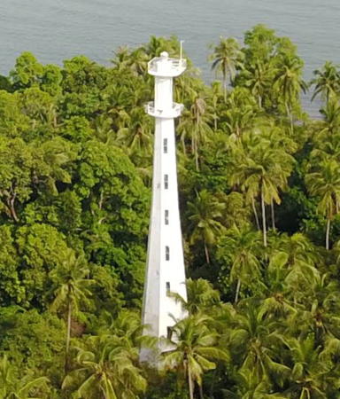
Date unknown. Active; focal plane 37 m (121 ft); white flash every 5 s. 30 m (98 ft) tapered octagonal aluminum tower with double gallery. Entire lighthouse is white. A portion of Willyarto Muhardani's aerial photo is at right, Tri Van Der Saryanto has a distant view, and Google has a satellite view. A sibling of the Takong Kecil Light (see above). Located on an islet about 25 km (15 mi) east of Tanjung Rambut. Accessible only by boat. Site status unknown. Admiralty F1694.6; NGA 22592.
Pulau Cula
Date unknown. Active; focal plane 16 m (52 ft); three white flashes every 15 s. 15 m (49 ft) octagonal white concrete tower with lantern and gallery. Trabas has a photo by Capt. Theo, Sisco Atawollo has a 2023 view from the sea, and Google has a satellite view. Eastbound vessels in the strait make a turn to the east as they approach the light. Located about 8 km (5 mi) south southwest of Takong Kecil (see below). Accessible only by boat. Site and tower closed. Admiralty F1693.9; NGA 21495.
Takong Kecil (Pulau Takong Kecil) (2)
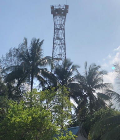
Date unknown (station established 1910). Active; focal plane 48 m (157 ft); two flashes every 10 s, white or red depending on direction. 30 m (98 ft) tapered octagonal aluminum tower. Entire lighthouse is white. A photo is at the top of this page, Trabas has a photo by Capt. Theo, Ririn Ambar has a 2013 view, Faisal D. Purnawarman has a closeup. Wikipedia has a distant view, and Bing has a satellite view. The present lighthouse was apparently built sometime shortly after World War II. It was rebuilt in 1998 and its height may have been increased at that time. Eastbound vessels in the strait pass just to the south of the lighthouse; westbound vessels pass to the north. Located on a small island in the strait about 7 km (4.5 mi) southwest of Singapore's famous Raffles Lighthouse. Accessible only by boat. Site and tower closed. Admiralty F1694; NGA 21480.

Western Singapore Strait South Side Lighthouses
These lights are on the south side of the channel for westbound ships departing the Singapore Strait.

North Nipa (Nipa Reef)
Date unknown. Active; focal plane 12 m (39 ft); 12 m (39 ft) round cylindrical tower mounted on a platform supported by four piles. Upper half of the tower painted black, lower half yellow. Trabas has Capt. Theo's closeup photo Google has an indistinct satellite view. In the Straits traffic separation scheme westbound vessels pass just to the north of this light (the black over yellow daymark is international code for "stay to the north"). Located about 2 km (1.25 mi) north of the Nipa Reef light (next entry). Accessible only by boat. Site open, tower closed. Admiralty F1691.8; NGA 21491.

Pulau Jangkat Light, Durian Strait, November 2017
ex-Google Plus drone view by Willyarto Muhardani
Pulau Nipa (Nipa Reef, Nipah Reef) (2)
Date unknown (station established 1912). Active; focal plane 16 m (52 ft); white flash every 3 s. 16 m (52 ft) round tower with gallery, mounted on an octagonal concrete pier. Lighthouse painted white. Aziz Banjar has a closeup photo, Feybe Lumanauw also has a closeup photo, Trabas has Capt. Theo's view from the sea, and Google has a satellite view. The original light had a focal plane of 11 m (36 ft). In the Straits traffic separation scheme westbound vessels pass just to the north of this light. Located on a dangerous reef about 10 km (6 mi) west of Singapore's famous Raffles Lighthouse. Accessible only by boat. Site open, tower closed. Admiralty F1692; NGA 21492.
Pulau Pelampong
Date unknown. Active; focal plane 18 m (56 ft); white flash every 4 s. 15 m (49 ft) square white skeletal tower. Trabas has Jim Smith's photo, the lighthouse is seen at the start of a YouTube video, and Google has a satellite view. Located at the north end of a reef about 5 km (3 mi) east southeast of Nipa Reef. Accessible only by boat. Site open, tower closed. Admiralty F1693.95; NGA 21487.

Central Singapore Strait South Side Lighthouses
Helen Mar Reef
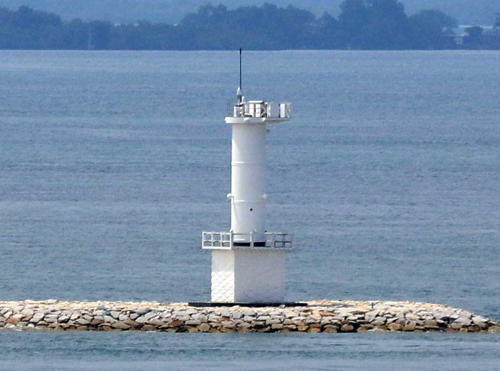
Date unknown. Active; focal plane 16 m (52 ft); white flash every 6 s. 16 m (52 ft) round cylindrical white concrete tower mounted on a square concrete pier. Trabas has Capt. Theo's photo (also seen at right), Arifki Parmanda has a 2020 photo, and Google has a satellite view. Eastbound vessels in the strait pass just to the north of the lighthouse. Located on a reef about 2.5 km (1.5 mi) northwest of Pemping Besar. Accessible only by boat. Site open, tower closed. Admiralty F1694.7; NGA 21476.

Helen Mar Reef Light, Singapore Strait
photo copyright Capt. Theo Hinrichs; used by permission
Karang Banteng (Buffalo Reef)
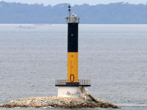
Date unknown. Active; focal plane 16 m (52 ft); quick-flashing white light. 16 m (52 ft) concrete tower with gallery. Upper half of the tower painted black, lower half yellow. Trabas has the closeup photo by Capt. Theo seen at right, Roni Marta has a photo, Marinetraffic.com has a photo (misidentified as Helen Mar Reef), and Google has a satellite view. Eastbound vessels in the strait pass just to the north of the lighthouse. Located on a reef about 12 km (7.5 mi) northeast of Pulau Takong Kecil. Accessible only by boat. Site open, tower closed. Admiralty F1695.6; NGA 21464.
Batu Berhanti (Pulau Berakit)
Date unknown (station established 1910). Active; focal plane 16.5 m (54 ft); white flash every 8 s. 16.5 m (54 ft) round concrete tower with four wings, mounted on a square concrete pier. Trabas has Rainer Arndt's closeup photo, Lightphotos.net has a good photo, and Google has a satellite view. The original light had a focal plane of 12 m (39 ft). All vessels pass just to the north of the lighthouse. Located on a shoal in the center of Singapore Strait, about 10 km (6 mi) south of downtown Singapore. Accessible only by boat. Site and tower closed. Admiralty F1696; NGA 21400.

Sekupang Area (Northern Batam) Lighthouses
Sekupang is a very busy ferry terminal at the northwestern corner of Batam; ferries link the city to Singapore across the strait.

Belakang Padang (2)
Date unknown. Active; focal plane about 15 m (49 ft); green flash every 5 s. Approx. 15 m (49 ft) square green skeletal tower on a platform supported by piles. Trabas has Capt. Theo's photo and Google has a satellite view. NGA lists a tower with a focal plane of only 7 m (23 ft). Located at the north end of a reef at the entrance to the Padang harbors, including the Pulau Sambu oil terminal. Accessible only by boat. Site open, tower closed. Admiralty F1697; NGA 21408.

Karang Banteng (Buffalo Reef) Light, Singapore Strait
photo copyright Capt. Theo Hinrichs; used by permission
Pulau Sambu
2017. Active; focal plane about 23 m (75 ft); flashing white light, period not listed. Approx. 20 m (66 ft) square white skeletal tower. Trihadi Prasojo-Gatet has a very distant aerial view (upper left near the end of the island) and Google has a satellite view. Located at the north end of the Pulau Sambu oil terminal. Site and tower closed. Admiralty F1697.13.
Pulau Mariam
Date unknown. Active; focal plane 29 m (95 ft); green flash every 3 s. 8 m (26 ft) round white concrete tower. Winston Paiva has a distant view of the top of the tower (behind island on the left), Si Kambing Wangi has a view from the sea (light on island to the right of the ship), and Google has an indistinct satellite view. NGA lists the light as "Mariaman." Located on a small island in the entrance to Sekupang harbor. Accessible only by boat. Site status unknown. Admiralty F1697.2; NGA 21412.
Pulau Mariam Southeast (2)
Date unknown. Active; focal plane about 14 m (46 ft); red flash every 2 s. Approx. 14 m (46 ft) square red skeletal tower on a platform supported by piles. A very distant aerial view is available (lighthouse offshore at upper right) and Google has a satellite view. NGA calls the light "Tenggara Marian" and describes it with focal plane 8 m (26 ft); the platform for that former light is seen in the satellite view. The light guides vessels approaching Sekupang. Located about 800 m (1/2 mi) off Tanjung Kemudi, the northwest tip of Pulau Batam. Accessible only by boat. Site open, tower closed. Admiralty F1697.3; NGA 21416.
Tanjung Kemudi (2)
Date unknown. Active; focal plane about 14 m (46 ft); two quick white flashes every 5 s. Approx. 14 m (46 ft) square skeletal tower, painted black with one red horizontal band, on a platform supported by piles. Suhandi Chang has a street view from shore and Google has a satellite view. NGA describes the light with focal plane 8 m (26 ft). Located on a shoal about 200 m (1/8 mi) off Tanjung Kemudi. Accessible only by boat. Site open, tower closed. Admiralty F1697.5; NGA 21436.
Sekupang North
Date unknown. Active; focal plane 8 m (26 ft); red flash every 6 s. 8 m (26 ft) tapered square red skeletal tower on a platform supported by piles. A photo is available and Google has a satellite view. This light and the next one guide ships in the narrow channel along the Sekupang waterfront. Located just off the Marina Farrasfarren near the north end of the waterfront. Site open, tower closed. Admiralty F1697.73; NGA 21428.
Sekupang West (2)
Date unknown. Active; focal plane about 14 m (46 ft); green flash every 7 s. Approx. 14 m (46 ft) square green skeletal tower on a platform supported by piles. Petta Nessa has a distant view, the light is at upper left in Lia Zahratin Ni'mah's aerial view, and Google has a satellite view. NGA describes the light with focal plane 5 m (16 ft). Located on a shoal about 300 m (1/5 mi) off the waterfront of Sekupang. Accessible only by boat. Site open, tower closed. Admiralty F1697.7; NGA 21424.
Pelabuhan Sekupang
2020. Active; focal plane 19 m (62 ft); white flash every 5 s. 17 m (56 ft) square white skeletal tower. No photo available but Google has a satellite view. Sekupang is a very busy ferry terminal at the northwestern corner of Batam; ferries link the city to Singapore across the strait. Located in the shipyard east of the ferry terminal. Site status unknown. Admiralty F1697.74.
Teluk Jodoh (Joduh, Batu Ampar)
Date unknown. Active; focal plane 20 m (66 ft); white flash every 5 s. 20 m (66 ft) square white skeletal tower mounted on a platform supported by piles. Located on a reef just off the Batam waterfront. No photo available but Google has a satellite view. Located on a shoal off the entrance to Jodoh, an industrial port on the north coast of Pulau Batam. Accessible only by boat. Site open, tower closed. Admiralty F1697.965; NGA 21460.5.

Eastern Batam (Riau Strait) Lighthouses
Pulau Nongsa (Pulau Putri)
1996. Active; focal plane 40 m (131 ft); white flash every 8 s. Approx. 37 m (121 ft) square skeletal tower with gallery, painted white. A 2018 street view is at right, Indra Labs has a similar street view, Tanjung Pinang Navigation District has an aerial photo, and Google has an indistinct satellite view. Pulau Nongsa and Pulau Putri are islets on the south side of the Singapore Strait about 30 km (19 mi) southeast of Singapore city. The lighthouse is actually on Pulau Putri. Accessible only by boat. Site and tower closed. ARLHS IDO-049; Admiralty F1697.99; NGA 21462.
Batu Besar (2?)
Date unknown. Active; focal plane about 15 m (49 ft); white flash every 5 s. Approx. 11 m (36 ft) square white skeletal tower. No photo available but Google has a satellite view. Located on the quay at a new port being built at the northeastern corner of Pulau Batam and the west side of the northern entrance to the Riau Strait. Site status unknown. Admiralty F1772.1; NGA 22618.

Pulau Nongsa Light, Singapore Strait, October 2018
Google Maps street view by Elendi
Karang Galang
Date unknown. Active; focal plane 13 m (43 ft); white flash every 6 s. 10 m (33 ft) metal tower painted with black and white horizontal bands. No photo available but Google has a satellite view. Located at the northeast corner of a reef in the northern entrance to the Riau Strait. Accessible only by boat. Site open, tower closed. Admiralty F1772; NGA 22620.
#Kabil (Range Rear)
Date unknown. Inactive since 2021 and apparently removed. Approx. 27 m (89 ft) square cylindrical white skeletal tower. Google has a 2019 street view but the tower is not seen in Google's satellite view. The range guided vessels to an oil terminal on the east coast of Batam. Located behind the port area at Kabil. Site and tower closed, but the lighthouse could be seen from a nearby road. ex-Admiralty F1772.31; NGA 22620.6.
 
Semen Bosowa
Date unknown. Active; focal plane about 14 m (46 ft); white flash every 3 s. 12 m (39 ft) square white skeletal tower. No photo available but Google has a satellite view. Located on the wharf of Semen Bosowa, a cement company. Site and tower closed. Admiralty F1772.36; NGA 22620.7.
Kabil South (ex-South Range Rear)
Date unknown. Active; focal plane 23 m (75 ft); white light, 2 s on, 1 s off. 23 m (75 ft) square cylindrical white skeletal tower mounted on a square concrete pier supported by piles. No photo available but Google has a satellite view. In 2019 the front light was removed and this light was reconfigured as a leading light. Located about 500 m (1/3 mi) south of the Kabil docks. Accessible only by boat. Site open, tower closed. Admiralty F1772.41; NGA 22621.5.
* Punggur Harbor (Pemprov Harbour, Tanjung Kasem)
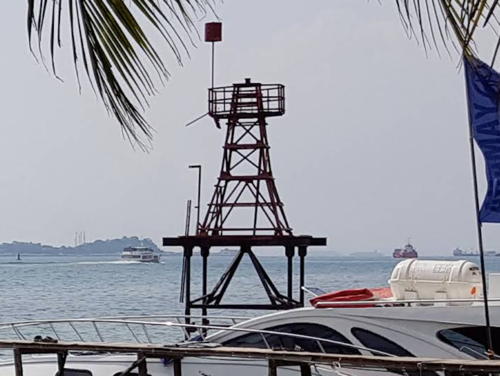
Date unknown. Active; focal plane 10 m (33 ft); white flash every 3 s. 10 m (33 ft) square white skeletal tower mounted on a platform supported by piles. Agung Sty's photo is at right, Marta Sari also has a photo, and Google has a satellite view. Located at the ferry terminal on the south side of Batam. Site open, tower closed. Admiralty F1772.48; NGA 22620.8.

Punggur Harbor Light, Batam, February 2015
ex-Panoramio Creative Commons photo by Agung Sty
Pulau Tanjungsau
Date unknown. Active; focal plane 34 m (112 ft); white flash every 5 s. 11 m (36 ft) white skeletal tower, apparently with lantern and gallery. No photo available but Google has an indistinct satellite view. Located on a headland projecting into the Riau Strait on the east side of Pulau Tanjungsau. Site status unknown. Admiralty F1774; NGA 22632.
Pulau Tungjuk Range Front
Date unknown. Active; focal plane 16 m (52 ft); white light, 1 s on, 1 s off. Approx. 14 m (46 ft) white skeletal tower. The range guides vessels in a long channel southbound in the Riau Strait. No photo available but Bing has a distant satellite view. Located on a small island off the southeastern coast of Pulau Batam. Accessible only by boat. Site status unknown. Admiralty F1780; NGA 22644.
Pulau Tungjuk Range Rear (2)
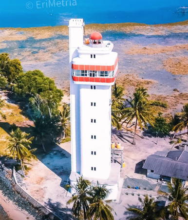
Around 2020. Active; focal plane about 37 m (120 ft); white light, 2 s on, 1 s off. Approx. 35 m (115 ft) square tower with lantern atop a traffic control center. Coast guard station with several buildings. Building painted white with red trim. Eri Metria has a closeup and an aerial view. This tower replaced a 20 m (66 ft) white skeletal tower. Bella Syafitri has a closeup 2018 photo of that tower and Google has a satellite view. Located 387 m (1/4 mi) south of the front light. Accessible only by boat. Site status unknown. Admiralty F1780.1; NGA 22648.
Pulau Karas Kecil
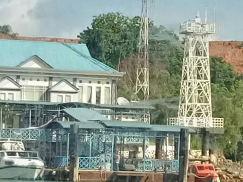
Date unknown. Active; focal plane 43 m (141 ft); white flash every 5 s. 11 m (36 ft) hexagonal white skeletal tower. Coast guard station with several buildings. A photo is at right, Hanjaya Mandala has a 2018 closeup photo, and Google has a satellite view of the station. Located at the eastern end of a small island in the southern entrance to the Riau Strait. Accessible only by boat. Site status unknown. Admiralty F1802; NGA 22676.

Information available on lost lighthouses:

Notable faux lighthouses:


Pulau Karas Kecilt Light, Batam, January 2019
Google Maps photo by Nasir

Adjoining pages: North: Singapore | East: Bintan and Lingga | South: Bangka | West: Eastern Sumatra

Return to the Lighthouse Directory index | Ratings key

Posted April 13, 2006. Checked and revised March 12, 2024. Lighthouses: 42. Site copyright 2024 Russ Rowlett and the University of North Carolina at Chapel Hill.