Lighthouses of Solomon Islands

The nation of Solomon Islands includes an archipelago off the east coast of New Guinea in the western South Pacific Ocean. The islands were colonized by Britain in the late 1800s. During World War II Japanese forces invaded from the north and were stopped by Allied forces in prolonged and heavy fighting in and around the island of Guadalcanal. The islands became independent in 1978. The country is a member of the British Commonwealth of Nations recognizing the British monarch is head of state. In recent years tourism in the Solomon Islands has been limited by civil unrest in many parts of the country.

Bougainville, the largest and northwesternmost island of the Solomon Archipelago, is not part of the nation of Solomon Islands. Instead, it is an autonomous province of Papua New Guinea expected to become independent in 2027.

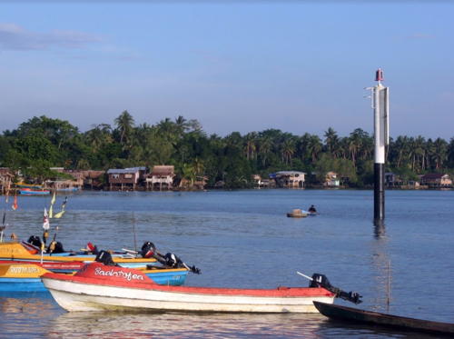
There have never been any traditional masonry lighthouses in the Solomon Islands. As recently as 2014 nearly all of the larger navigational aids were described as "framework towers" in the international light lists. However, there must have been a major project to replace these beacons beginning around that time. Now nearly all of the lightbeacons are described as "white columns." Photos are not available but satellite images suggest that these "white columns" are round metal or fiberglass towers similar to the Honiara range light shown at right. Photos of any of these new lights would be welcome!

Honiara and Noro are the two international ports in the Solomon Islands. These ports are operated by the Solomon Islands Ports Authority, which is probably responsible for aids to navigation in the islands.

ARLHS numbers are from the ARLHS World List of Lights. Admiralty numbers are from volume K of the Admiralty List of Lights & Fog Signals. U.S. NGA List numbers are from Publication 111.

General Sources
World of Lighthouses - Solomon Islands
Photos by various photographers available from Lightphotos.net.
Online List of Lights - Solomon Islands
Photos by various photographers posted by Alexander Trabas.
Navionics Charts
Navigational chart information for the Solomons.

Honiara Harbour Light
Honiara Harbor Range Front Light, Guadalcanal
photo copyright Nawae Construction; used by permission

Choiseul Province Lighthouse
Papara Voghöe Point
Date unknown. Active; focal plane 51 m (167 ft); one long (1.5 s) flash every 10 s, white, red or green depending on direction. 12 m (39 ft) square steel skeletal tower with gallery, painted white. No photo available and the tower is not seen in Bing's satellite view of the location. Located on a prominent headland on the south coast of Choiseul, the northwesternmost major island of the archipelago. Site status unknown. Admiralty K4892; NGA 10772.

Western Province (New Georgia Area) Lighthouses
Onua Island (2)
Date unknown. Active; focal plane 10 m (33 ft); white flash every 10 s. 10 m (33 ft) "white column." No photo available but Google has a satellite view. Located on a reef off the southeast corner of Shortland Island. Accessible only by boat. Site open, tower closed. Admiralty K4889; NGA 10792.
Munda Range Rear (2)
Date unknown. Active; focal plane 12 m (39 ft); three quick white flashes every 15 s. 11 m (36 ft) "white column." The tower also carries a large white triangular daymark. A 2000 postage stamp depicts the original light tower (right stamp of the pair below) and Bing has a fuzzy satellite view. Located off Munda on the south side of the island of New Georgia. Accessible only by boat. Site open, tower closed. ARLHS SOL-001; Admiralty K4896.41; NGA 10740.
Kunda Kunda (Kundu Kundu) Reef (2)
Date unknown. Active; focal plane 10 m (33 ft); white flash every 10 s. 10 m (33 ft) "white column." No photo available but Bing has a satellite view. Located on a reef on the north side of the western entrance to the passage between New Georgia and Rendova Islands. Accessible only by boat. Site open, tower closed. Admiralty K4896; NGA 10732.

Santa Isabel Province Lighthouse
Sogna Reef (Tasla Island) (2)
Date unknown. Active; focal plane 10 m (33 ft); white flash every 10 s. 10 m (33 ft) "white column." No photo available and the light is not seen in Google's satellite view. Located on a reef off the north coast of Santa Isabel, marking the beginning of the passage leading to the provincial capital of Buala. Accessible only by boat. Site open, tower closed. Admiralty K4898.7; NGA 10688.

Malaita Province Lighthouse
Auki Outer Reef (2)
Date unknown. Active; focal plane 10 m (33 ft); two quick white flashes every 10 s. 10 m (33 ft) "white column." No photo available but Bing has a distant satellite view. Located on a reef on the south side of the entrance to Auki harbor. Accessible only by boat. Site open, tower closed. Admiralty K4903; NGA 10712.
[Auki Range Rear]
Date unknown. Active; focal plane 10 m (33 ft); red flash every 1.5 s. 10 m (33 ft) white post. A photo is at right, Nick Hobgood has a street view showing both lights, and Google has a satellite view showing both range lights. It's possible many of the "white column" lights resemble this one. Located just offshore in Auki Harbor. Site open, tower closed. Admiralty K4902.1; NGA 10708.

Central Province (Tulagi Area) Lighthouses
Russell Islands (Lagholon Island, Lanalau Islet) (2)
Date unknown. Active; focal plane 11 m (36 ft); white flash every 10 s. 11 m (36 ft) "white column." No photo available but Bing has a distant satellite view. The light guides vessels in what became known during World War II as The Slot: the channel between Santa Isabel and New Georgia pointing towards Guadalcanal. Located on a small island at the northeastern corner of the Russell Islands, about 65 km (40 mi) west northwest of Cape Esperance. Accessible only by boat. Site status unknown. ARLHS SOL-005; Admiralty K4920; NGA 10724.
Mboli (Siota) Harbor (Utuha Passage) (2)
Date unknown. Active; focal plane 10 m (33 ft); white flash every 10 s. 10 m (33 ft) "white column." No photo available but Google has a distant satellite view. Located off the east side of the entrance to the harbor and to the narrow passage between Nggela Sule (Florida Island) and the neighboring island of Nggela Pile. Accessible only by boat. Site open, tower closed. Admiralty K4912; NGA 10672.

Auki Range Rear Light, Malaita, August 2013
Google Maps photo by Peacebuilders International
Indalilau Islet (2)
Date unknown. Active; focal plane 10 m (33 ft); two white flashes every 10 s. 10 m (33 ft) "white column." No photo available but Google has a distant satellite view. Located on an islet off the southern tip of Nggela Sule (Florida Island) about 40 km (25 mi) southeast of Tulagi. Accessible only by boat. Site open, tower closed. Admiralty K4906; NGA 10680.
Tuituhi (Lyons) Point (2)
Date unknown. Active; focal plane 10 m (33 ft); three white flashes every 20 s. 10 m (33 ft) "white column." No photo available but Google has a distant satellite view. Located off the southeastern tip of Nggela Sule (Florida Island) about 16 km (10 mi) southeast of Tulagi. Accessible only by boat. Site open, tower closed. ARLHS SOL-003; Admiralty K4907; NGA 10668.
Tulagi Harbor Range Front (2)
Date unknown. Active; focal plane 10 m (33 ft); red flash every 5 s. 9 m (30 ft) square steel skeletal tower with lantern and gallery, painted white; lantern painted black. A 2000 postage stamp depicts the original lighthouse (left stamp of the pair at right), and Google has a satellite view. Located off the harbor of Tulagi in Iron Bottom Sound, the scene of many naval battles during World War II. Accessible only by boat. Site open, tower closed. ARLHS SOL-007; Admiralty K4908; NGA 10660.
Tulagi Harbor Range Rear (2)
Date unknown. Active; focal plane 14 m (46 ft); two white flashes every 10 s. 12 m (39 ft) square steel skeletal tower with lantern and gallery, painted white; lantern painted black. No photo available but Google has an indistinct satellite view. Located at the tip of a promontory of the mainland, 1145 m (3750 ft) north of the front light. Accessible only by boat. Site open, tower closed. ARLHS SOL-002; Admiralty K4908.1; NGA 10664.
Tulagi and Munda Lights
Tulagi Harbor Front Light (left) and Munda Rear Light
2000 postage stamp minisheet
Soghonangola
Date unknown. Active; focal plane 10 m (33 ft); two red flashes every 10 s. 10 m (33 ft) "white column." No photo available and the light is not seen in Google's distant satellite view. Located off the southern tip of Soghonangola Island on the west side of the entrance to Tulagi Harbor. Accessible only by boat. Site open, tower closed. Admiralty K4909; NGA 10665.

Guadalcanal Province Lighthouses
Cape Esperance (2)
Date unknown. Active; focal plane 10 m (33 ft); white flash every 10 s. 10 m (33 ft) "white column," apparently a round barbell-shaped fiberglass tower. No photo available and the light has not been found in Google's satellite view. The original lighthouse was an approx. 25 m (82 ft) square pyramidal skeletal tower, painted white. Cape Esperance was the site of one of the crucial naval battles in October 1942. Located near the northwestern tip of Guadalcanal. Site open, tower closed. Admiralty K4932; NGA 10652.
* Honiara Harbour (Honiara Anchorage Range Front) (2)
Date unknown. Active; focal plane 13 m (43 ft); red flash every 5 s. 11 m (36 ft) round barbell-shaped fiberglass tower, colored with red and white horizontal bands and mounted on a square concrete base. A Nawae Construction photo is at the top of this page, Lightphotos.net has a photo by Gennadiy Sushchenko, Jason Smart has a photo, Nick Hobgood has a street view, and Google has a distant satellite view. Located on the Honiara waterfront, near the ferry pier. Site open, tower closed. Admiralty K4934; NGA 10636.
* Vavaya Ridge (Honiara Anchorage Range Rear)
Date unknown. Active; focal plane unknown; green flash every 5 s. Approx. 11 m (36 ft) round cylindrical tower, colored white. Yuriy Dzhygyr's distant view is at right and Google has a distant satellite view. Located beside a road a short distance west of the Solomon Islands Parliament building. Site open, tower closed. Admiralty K4934.1; NGA 10640.
Taivu Point (2)
Date unknown. Active; focal plane 10 m (33 ft); two long (2 s) white flashes every 20 s. 10 m (33 ft) "white column." No photo available but Bing has an indistinct satellite view. Located off the point on the northeastern shoulder of Guadalcanal. Accessible only by boat. Site open, tower closed. ARLHS SOL-006; Admiralty K4944; NGA 10616.
Northwest Reef (2)
Date unknown. Active; focal plane 10 m (33 ft); three white flashes every 15 s. 10 m (33 ft) "white column." No photo available but Bing has a distant satellite view. Located on a dangerous reef off the northeastern coast of Guadalcanal. Accessible only by boat. Site open, tower closed. Admiralty K4945; NGA 10612.
Rere Point (2)
Date unknown. Active; focal plane 10 m (33 ft); white flash every 5 s. 10 m (33 ft) "white column." No photo available but Bing has a fuzzy satellite view. The original light was an 18 m (59 ft) square steel skeletal tower, painted with red and white horizontal bands. Located just off a promontory on the northeast coast of Guadalcanal. Site open, tower closed. ARLHS SOL-004; Admiralty K4946; NGA 10608.

Vavya Ridge Light, Honiara, February 2010
Google Maps photo by Yuriy Dzhygyr
Tawara'o (Square) Island (2)
Date unknown. Active; focal plane 10 m (33 ft); white flash every 10 s. 10 m (33 ft) "white column." This light replaced a 13 m (43 ft) square cylindrical skeletal tower, painted white and mounted on a platform supported by piles. No photo available but Bing has a fuzzy satellite view. Square Island is an islet off the southeastern tip of Guadalcanal. Located on a reef off the northeast side of the island. Accessible only by boat. Site open, tower closed. Admiralty K4947; NGA 10584.

Makira-Ulawa Province (San Cristóbal) Lighthouse
Wangalaha Point
Date unknown. Reported inactive as of 2022. Skeletal tower, painted white. The tower height is not known, but this location would require a tall tower. No photo available and Bing's satellite view may show the light station but fails to show the tower. Located on a promontory near Wango on the north coast of Makira (formerly known as San Cristóbal). Site open, tower closed. ex-Admiralty K4947.6; NGA 10576.

Information available on lost lighthouses:

Notable faux lighthouses:

Adjoining pages: South: Vanuatu | Northwest: Northern Papua New Guinea

Return to the Lighthouse Directory index | Ratings key

Posted January 5, 2006. Checked and revised November 15, 2023. Lighthouses: 21. Site copyright 2023 Russ Rowlett and the University of North Carolina at Chapel Hill.