Lighthouses of Saint Pierre and Miquelon

The French overseas territory (collectivité d'outre-mer) of Saint Pierre and Miquelon consists of a small group of islands in the entrance to Fortune Bay off the south coast of Newfoundland. Settled in 1604, the islands are the only remaining portion of France's former empire in North America. Currently the population is about 6000. Despite its small size the territory has six lighthouses, five active. The islands are accessible by air or by passenger ferry from Fortune, Newfoundland.

Special thanks to André Lafargue for providing information on the history of these lighthouses, as well as excellent photos.

The French word for a lighthouse, phare, is often reserved for the larger coastal lighthouses; a smaller light or harbor light is called a feu (literally "fire," but here meaning "light") or a balise (beacon). The front light of a range (alignement) is the feu antérieur and the rear light is the feu postérieur. In French île is an island, cap is a cape, pointe is a promontory or point of land, rocher is a rock, récife is a reef, baie is a bay, estuaire is an estuary or inlet, détroit is a strait, rivière is a river, and havre is a harbor.

The lighthouses of the islands are operated by the territory's public works agency, the Direction des Territoires, de l'Alimentation et de la Mer (DTAM).

ARLHS numbers are from the ARLHS World List of Lights. Admiralty numbers are from Volume H of the Admiralty List of Lights & Fog Signals. U.S. NGA numbers are from Publication 110. The lights of St. Pierre and Miquelon have been dropped from the List of Lights, Buoys, and Fog Signals of Fisheries and Oceans Canada; ex-CCG numbers are their former designations.

General Sources
Lighthouses of St.-Pierre and Miquelon
Photos contributed by André Lafargue.
Online List of Lights - Saint Pierre and Miquelon
Photos various photographers posted by Alexander Trabas. For this territory most of the photos are by Klaus Wolfgang.
Lighthouses of St. Pierre et Miquelon
Photos contributed by André Larfargue.
World of Lighthouses - St. Pierre and Miquelon
Photos by various photographers available from Lightphotos.net.
Lighthouses in Saint-Pierre and Miquelon
Photos by various photographers available from Wikimedia.
Photos by Roger Etcheberry
Newfoundland lighthouse photos posted on MarineTraffic.com
Leuchttürme Kanadas auf historischen Postkarten
Historic postcard views of Canadian lighthouses posted by Klaus Huelse. Lighthouses of St. Pierre and Miquelon are at the bottom of the page.
GPSNauticalCharts
Navigation chart for the islands.
Navionics Charts
Navigation chart for the islands.


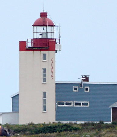
Tête de Galantry Light, Saint-Pierre, September 2019
Wikimedia Creative Commons photo by Bernard Saliba

Île de Saint-Pierre Lighthouses
The Île de Saint-Pierre is the smaller of the two main islands of the territory but it is the more densely populated, including the principal town of Saint-Pierre.

Rocher Petit Saint-Pierre
1924. Active; focal plane 13 m (43 ft); flash every 2 s, red or white depending on direction. 12 m (39 ft) round solid masonry tower, painted white with a horizontal red band; the small lantern is also red. Trabas has Wolfgang's closeup photo, Etcheberry has a photo, André Lafargue has contributed a photo, a distant sea view is available, and Google has a satellite view. The tower formerly carried a conventional lantern room. Located on a tiny waveswept rock off the northern entrance to the harbor of Saint-Pierre. Accessible only by boat. Site and tower closed. Site manager: government of St.-Pierre et Miquelon. ARLHS SPM-007; ex-CCG 087; Admiralty H0338; NGA 2172.
* Île aux Marins (Île aux Chiens)
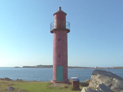
1874. Inactive but charted as a landmark. Approx. 14 m (47 ft) round cylindrical cast iron tower with lantern and gallery, painted red. Bernard Saliba's photo is at right, Etcheberry has a photo, André Lafargue has contributed a photo and Google has a street view, a satellite view, and a distant sea view. Inhabited until the 1950s, the island is now a historic site. Its name was changed from Île aux Chiens (Dog Island) to Île aux Marins (Sailors Island) in 1931. Located at the southwestern tip of the island, which shelters the harbor of Saint-Pierre. Accessible only by boat. Tours of the island are available in season. Site open, tower closed. Site manager: government of St.-Pierre et Miquelon. ARLHS SPM-009.

Île aux Marins Light, Saint-Pierre, June 2019
Wikimedia Creative Commons photo by Bernard Saliba
* Pointe aux Canons (Saint-Pierre)
1862. Inactive. 11 m (35 ft) octagonal stone tower with gallery, painted white with a horizontal red band. The original lantern has been removed, and the light is mounted in a small enclosure at the top of a dome-shaped platform atop the tower. Enclosure, dome and gallery painted red. Pascal Carrere's photo is at right, a fine September 2006 closeup shows the lighthouse with a fresh coat of paint, a 2017 photo is available, Lafargue has also contributed a photo, Etcheberry has a photo, Huelse has a historic postcard view, and Google has a sea view and a satellite view. The point is named for the 18th century cannons standing guard nearby. The lighthouse was the front light of a range from 1887 to the 1960s, but the rear lighthouse (known as the Feu Rouge) has been demolished (see below). The lighthouse was originally painted all white; a black horizontal band was added in the 1930s, and later the color of the band was changed to red. The light lost its navigational value after the outer breakwaters were constructed. Located at the end of a stone pier in the harbor at Saint-Pierre. Accessible by walking the pier. Site open, tower closed. Site manager: government of St.-Pierre et Miquelon. . ARLHS SPM-010.
* Terre-plein Sud
Date unknown. Active; focal plane 8 m (26 ft); three green flashes every 12 s. 6.5 m (21 ft) mast centered on a 1-story square equipment shelter. Mast painted green, equipment shelter white. Trabas has Wolfgang's closeup photo and Google has a sea view and a satellite view. Located at the end of pier on the south side of Saint-Pierre Harbor. Site open, tower closed. Site manager: government of St.-Pierre et Miquelon. Admiralty H0345; NGA 2180.
Rocher Bertrand
1926. Inactive for many years but maintained as a daybeacon. Approx. 8 m (26 ft) round stepped stone or concrete tower painted with black and white horizontal bands. Lightphotos.net has a distant view and Google has a satellite view. Located on a reef in the southern entrance to the harbor of Saint-Pierre. Accessible only by boat. Site and tower closed.
* Galantry (Tête de Galantry) (2)
1978 (station established 1845). Active; focal plane 47 m (154 ft); two white flashes (separated by 2.5 s) every 10 s. 18 m (60 ft) triangular cylindrical concrete tower with lantern and gallery, painted white; lantern is red. Fog horn (2 blasts every 60 s). 1-1/2 story keeper's house. Bernard Saliba's photo is at the top of this page, Karl Josker has a photo, DTAM has a page on the history of the light station, Trabas has Wolfgang's photo, Etcheberry has a photo, and Google has a street view and a satellite view. Known locally as the Nouveau (new) Phare de Galantry. The original lighthouse was demolished in 1980 because its hilltop location was thought to be a hazard to airplanes arriving or departing. André Lafargue has contributed a 1978 photo showing the old and new lighthouses, and Huelse has a historic postcard view of the original light. Located on the southeastern shore of Île Saint-Pierre. The station is accessible by road from the town of Saint-Pierre. Site open, tower closed. Site manager: government of St.-Pierre et Miquelon. . ARLHS SPM-008; ex-CCG 080; Admiralty H0332; NGA 2160.

Pointe aux Canons Light, St.-Pierre, August 2017
Flickr Creative Commons photo by Pascal Carrere

Miquelon-Langlade Lighthouses
Miquelon-Langlade actually consists of three islands, known as Le Cap, Miquelon, and Langlade, that are joined presently by sandbars. Geographers call such an arrangement a tombolo cluster. Most of the population of about 600 lives in the village of Miquelon, on Le Cap. Langlade, the southernmost island, is uninhabited.
Pointe Plate (Île Langlade)
1881. Active; focal plane 48 m (157 ft); alternating red and white lights, 1 s on, 3 s off. 43 m (141 ft) square pyramidal skeletal tower, cast iron encased in concrete, with octagonal central cylinder, lantern and gallery. Tower painted white; the lantern and watch room are red. The 1-story keeper's house appears to be in ruins. This is a remarkable lighthouse, taller than any Canadian light and comparable to the tallest U.S. skeletal lighthouses. Trabas has Jim Smith's photo, Etcheberry has a photo, Michaël Boissel has a good 2023 drone view, and Google has a satellite view. The central cylinder was encased in concrete in 1928 and the legs in 1950 to stop corrosion of the iron structure. Huelse has a historic postcard view of the light before these modifications were made. Located at the southwestern tip of Île Langlade, which is connected to Miquelon by a narrow, sandy isthmus. Accessible only by boat. Site open, tower closed. Site manager: government of St.-Pierre et Miquelon. ARLHS SPM-001; ex-CCG 090; Admiralty H0330; NGA 2208.
* Cap Blanc (Miquelon)
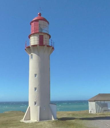
1883. Active; focal plane 32 m (105 ft); three flashes every 15 s, alternating red and white. 19 m (62 ft) round cylindrical cast iron tower, encased in concrete, with six small buttresses at the base, lantern, and gallery. Tower is unpainted white concrete; lantern and gallery rail are painted red. Fresnel lens in use. 1-story keeper's house. A photo is at right, Henry Masson has a 2009 photo, Philippe Richard has a good photo, Camille Martin has a 2022 closeup, Huelse also has a historic postcard view (ca. 1926), and Google has a street view and a satellite view. Located on a headland on Le Cap, the northwestern tip of Miquelon. Accessible by road from the town of Miquelon. Site open, tower closed. Site manager: government of St.-Pierre et Miquelon. ARLHS SPM-002; ex-CCG 093; Admiralty H0328; NGA 2212.
* Miquelon Jetty
Date unknown. Active; focal plane 10 m (33 ft); flash every 2.5 s, white, red or green depending on direction. 8 m (26 ft) mast centered on a 1-story square equipment shelter. Entire lighthouse is white. Google has a street view and a satellite view. Located at the end of the main breakwater pier of the town of Miquelon. Site open, tower closed. Site manager: government of St.-Pierre et Miquelon. ARLHS SPM-003; ex-CCG 094; Admiralty H0329; NGA 2216.

Cap Blanc Light, Miquelon, May 2015
Wikimedia Creative Commons photo by Bernard975

Information available on lost lighthouses:

Notable faux lighthouses:

Adjoining pages: North: Southwestern Newfoundland | East: Southeastern Newfoundland

Return to the Lighthouse Directory index

Posted November 26, 2002. Checked and revised July 10, 2023. Lighthouses: 8. Site copyright 2023 Russ Rowlett and the University of North Carolina at Chapel Hill.