Lighthouses of the Southern Spratly Islands

The Spratly Islands (as they are known historically in the West) are a group of more than 100 islands and reefs spread across an elliptical area 1000 km (625 mi) long and 400 km (250 mi) wide in the South China Sea northwest of Borneo, southwest of the Philippines, and east of Vietnam. The history of the islands is long but poorly known. Historically they were often visited by fishermen but never inhabited permanently. Both China and Vietnam assumed ownership of them. In 1933 France claimed the islands formally as part of French Indochina and China responded by filing its own claim in 1935. During World War II Japan (then in possession of Taiwan) established several bases in the islands. The scramble to exert control of the islands began soon after the war. Presently Vietnam, China, and Taiwan claim all of the islands, the Philippines claims most of them, Malaysia claims some of them, Brunei claims one of them, and Indonesia has economic interests in the area although it has made no formal claims.

Following the reunification of the country in 1975 Vietnam moved quickly to establish a presence in the Spratlys. More recently China has occupied many of the islands and established several large bases. Taiwan, Malaysia, and the Philippines also occupy several islands. All five countries have established navigational lights in the Spratlys and Vietnam and China have built multiple major lighthouses. These lights do have navigational value but they are also built as assertions of sovereignty, even though international tribunals have ruled several times that building a lighthouse does not establish ownership of an island.

Please note that the Lighthouse Directory does not express support for any nation in the disputes over this area. The only purpose of this page is to list and describe the lighthouses of the islands. They are grouped by geography. The various reefs are identified by their "international" (that is, Western) names. Each island is identified by the name used by the occupying nation with the Western name in parentheses.

In China, including Taiwan, the South China Sea is called the South Sea (Nán Hǎi) and the Spratlys are called the Nánshā Islands. The People's Republic's territories are attached administratively to Hǎinán Province. In 2012 China announced the creation of the prefectural-level city of Sānshā, including the Paracel Islands (Xīshā) and the Nánshā Islands. Taiwan's territories are administered as part of Kaohsiung City.

In Vietnam the South China Sea is called the East Sea (Biển Đông) and the Spratlys are called Trường Sa. The Vietnamese territories are administered as a county of Khánh Hòa Province.

In the Philippines the South China Sea is called the West Philippine Sea and the Spratlys are called the Kalayaan Islands. The Philippine territories are administered as the Kalayaan municipality of Palawan Province.

Malaysia uses the translated Western names of the South China Sea (Laut Cina Selatan) and Spratly Islands (Kepulauan Spratly). The Malaysian territories are administered by Sabah state.

This page includes lighthouse on the reefs and islands south of latitude 9° north. The Northern Spratly Islands page covers the rest of the archipelago.

ARLHS numbers are from the ARLHS World List of Lights. Admiralty numbers are from volume F of the Admiralty List of Lights & Fog Signals. U.S. NGA List numbers are from Publication 112.


Huáyáng Jiāo Light, Cuarteron Reef
PRC Navy photo
General Sources
Online List of Lights - Spratly Islands
Photos by various photographers posted by Alexander Trabas.
Spratly Islands Map
A useful map posted by the University of Texas Library.
Southern Vietnam Maritime Safety - Lighthouses
An interactive map of lighthouse locations, linking to pages on the individual light stations.
Quần đảo Trường Sa (Spratly Islands)
This article in the Vietnamese language edition of Wikipedia has greater detail than any other known Internet source on the history and status of the individual islands; it is written from the Vietnamese point of view, of course.
南沙群岛 (Nánshā qúndǎo)
Chinese Wikipedia's article on the islands.
Kalayaan, Palawan
This English-language Wikipedia article presents the islands from the Philippines point of view and includes a map of the islands posted by the Philippines givernment.
Vietnam Spratly Islands
This Flickr.com group has photos of several of the Vietnamese lighthouses.
Spratly Islands (Kepuluan ng Kalayaan)
Slideshow on the Spratlys from a Philippine poimt of view.
Malaysia Island Tracker
From the Asia Maritime Transparency Initiative, aerial photos of the five Malaysian installations.
Who Occupies What in the Spratly's?
From The Diplomat, lists of islands occupied by each country as of 2016.
GPSNauticalCharts
Navigational chart of the islands.
Navionics Charts
Navigational chart of the islands.

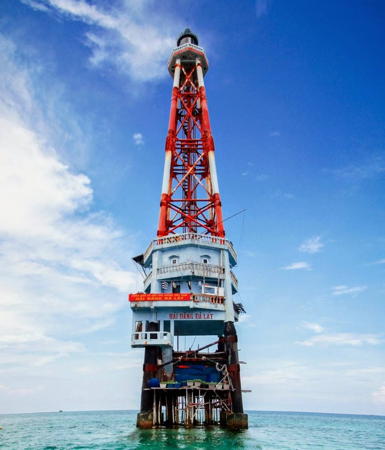
Đá Lát Light, Ladd Reef, October 2021
Google Maps photo by Dinh Tuan

Western Reefs Lighthouses

London Reefs Lighthouses
The London Reefs are four reefs arranged in a rough east to west line about 100 km (60 mi) southwest of Fiery Cross Reef.

China: Huáyáng Jiāo (Cuarteron Reef)
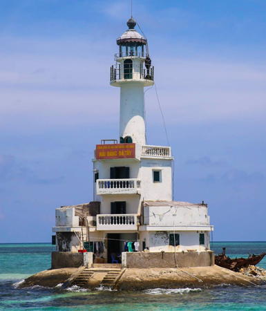
2015 (station established late 1980s). Active; focal plane about 52 m (171 ft); white flash every 8 s. 50 m (164 ft) round concrete tower with lantern and gallery, painted white. A photo is at the top of this page and Google has a satellite view. This lighthouse replaced a light mounted on a short mast atop a 3-story military outpost.; Trần văn Linh has a closeup photo. Cuarteron Reef is a small reef at the eastern end of the London Reefs. It was awash at high tide until 1988, when China began building a military base on a concrete pier. The artficial island has been expnded to 23 hectares (57 acres). This is China's southernmost outpost in the Spratlys; the Chinese name means "China Sun Reef." Site and tower closed. Admiralty F2825.16; NGA 20290.11.
Vietnam: Đá Đông (East London Reef) A
2010. Active; focal plane about 15 m (49 ft); three white flashes every 12 s. Light mounted on a short skeletal tower atop a 2-story building constructed on a concrete pier. Trần văn Linh has a 2018 photo, another photo (2/3 the way down the page) is available and Google has a satellite view. East London Reef is a narrow atoll about 10 km (6 mi) long and roughly 15 km (9 mi) west of Cuarteron Reef. The reef is awash at low tide. This Vietnamese base is at the east end of the reef. Site and tower closed. Admiralty F2825.156.
Vietnam: Đá Đông (East London Reef) C
2010. Active; focal plane about 15 m (49 ft); four white flashes every 15 s. Light mounted on a short skeletal tower atop a 2-story building constructed on a concrete pier. Trần văn Linh has a 2016 photo, another photo (first photo on the page) is available and Google has a satellite view. This Vietnamese base is on the north side of the reef about midway along its length. Site and tower closed. Admiralty F2825.155.
Vietnam: Đá Đông (East London Reef) B
2010. Active; focal plane about 15 m (49 ft); two white flashes every 10 s. Light mounted on a short skeletal tower atop a 2-story building constructed on a concrete pier. The light is at the left in a photo (second photo on the page) and Google has a satellite view. This Vietnamese base is at the west end of the reef. Site and tower closed. Admiralty F2825.154.
Vietnam: Đá Giữa (Central London Reef)
Date unknown. Active; focal plane about 15 m (49 ft); white flash every 4 s. Light mounted on a short skeletal tower atop a 2-story building. A view from the sea is available, Đoàn Khắc Việt has a second view from the sea, and Google has a satellite view. Central London Reef is a small reef about 12 km (7.5 mi) northeast of West London Reef; its main island has an area of about 1.6 ha (4 acres). Vietnam has occupied the island since 1978. Located on the main island inside the reef. Site and tower closed. Admiralty F2825.153.
Vietnam: Đá Tây (West London Reef) A
Date unknown. Active; focal plane about 15 m (49 ft); three white flashes, in a 2+1 pattern, every 10 s. Trọng Tâm Đào has a 2013 photo, another photo (second photo on the page) is available and Google has a satellite view. West London Reef is an atoll about 8 km (5 mi) long and 4 km (2.5 mi) wide. Located on an islet at the east end of the reef; this islet has been expanded into a substantial base. Site and tower closed. Admiralty F2825.152.
Vietnam: Đá Tây (West London Reef) C
Date unknown. Active; focal plane about 15 m (49 ft); four white flashes, in a 3+1 pattern, every 20 s. Light mounted on a short skeletal tower atop a 2-story building constructed on a concrete pier. No photo available but Google has a satellite view. This Vietnamese base is on the north side of the reef. Site and tower closed. Admiralty F2825.151.
Vietnam: Đá Tây (West London Reef) B
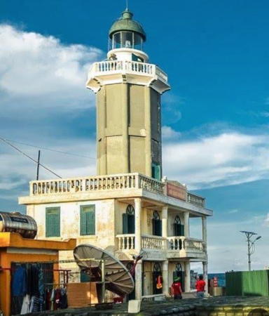
1994. Active; focal plane 22 m (72 ft); three white flashes every 10 s. 20 m (66 ft) cylindrical tower with lantern and gallery rising from the center of a multistory station building. Tower painted gray; station building painted yellow. Thi Huynh's 2021 photo is at right, a 2013 photo is available, and Google has a satellite view. Located on a tiny scrap of land at the east end of the reef. Site and tower closed. ARLHS SPR-008; Admiralty F2825.15; NGA 20290.1.
 

Đá Tây Light, West London Reef, September 2021
Google Maps photo by Thi Huynh

Spratly Island and Ladd Reef Lighthouses
Vietnam: Trường Sa Lớn (Spratly Island)
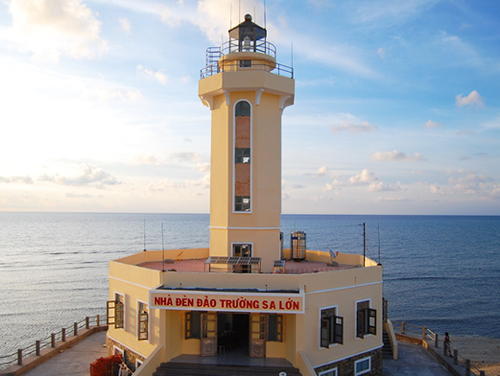
2009 (?). Active; focal plane 25 m (82 ft); white flash every 10 s. Approx. 20 m (66 ft) octagonal cylindrical concrete tower with lantern and gallery, rising from a 1-story station building. Building and lighthouse painted yellow with white trim. Phạm Xuân Nguyên's 2010 photo is at right, a 2013 closeup photo is available, and Google has a satellite view. Spratly Island is a 17 hectare (37 acre) island that has some of the highest land in the islands, reaching an altitude of 5 m (17 ft) above high tide. France annexed this island to its Vietnam colony in 1933. The South Vietnamese government established a small base on the island in 1974 and Vietnam has occupied it ever since, establishing one of its most important bases in the archipelago; it is the administrative center for Vietnamese settlements and bases in the Spratlys. It is surprising that it took so long to build a lighthouse. The island has a recently-extended airstrip and housing for a semi-permanent population; with a weather station, a primary school, and a Buddhist pagoda. The island was named for the British whaling captain Richard Spratly, who sighted it in 1843; his name was later assigned to the entire archipelago. Site and tower closed. Admiralty F2825.08.
Vietnam: Đá Lát (Ladd Reef)
1994. Active; focal plane 40 m (131 ft); white flash every 5 s. 42 m (138 ft) square pyramidal steel skeletal tower with lantern and gallery mounted on a 3-story octagonal station building, all standing on concrete and steel piles. Lighthouse painted with red and white horizontal bands. Dinh Tuan has a 2021 photo but Google has only a fuzzy satellite view. Ladd Reef is a small reef, dry only at low tide, about 20 km (13 mi) west of Spratly Island. China is said to have placed a marker here in 1992, which probably encouraged action by Vietnam to occupy the area. A 2015 photo of the Vietnamese base is available; the lighthouse is seen in the background. In 2016 Vietnam began dredging work at the reef, presumably in preparation for building a larger base. The lighthouse is near the west end of the reef, about 800 m (1/2 mi) west of the Vietnamese base. Site and tower closed. ARLHS SPR-004; Admiralty F2825.1; NGA 20290.

Trường Sa Lớn Light, Spratly Island, May 2010
Vietnamese Wikipedia public domain photo by Phạm Xuân Nguyên

Southern Reefs Lighthouses

Pigeon Reef (Tennent Reef) Lighthouses
The mostly-submerged Pigeon Reef, also called Tennent Reef, is 100 km (63 mi) south of Union Banks and 265 km (165 mi) due east of West Reef in the central Spratlys; its occupation by Vietnam represented a significant geographical extension of Vietnamese activity eastward in the islands. The reef is a tiny triangular atoll about 2 km (1.25 mi) in diameter; it is submerged except for a few rocks at high tide.
Vietnam: Tiên Nữ (Pigeon Reef, Tennent Reef) Northeast
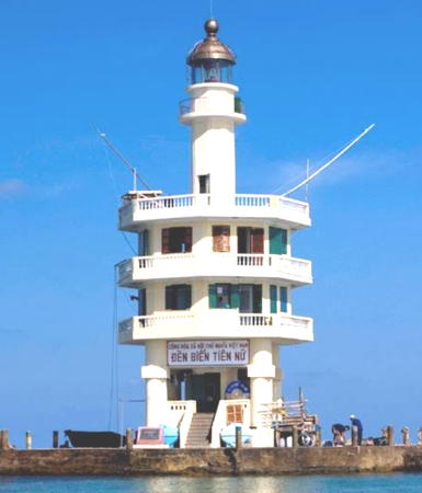
2000. Active; focal plane 22 m (72 ft); three white flashes, in a 2+1 pattern, every 10 s. 20.5 m (67 ft) round concrete tower with lantern and gallery centered on a 3-story octagonal crew quarters building. Lighthouse painted beige with blue trim. Trần văn Linh's 2018 photo is at right, a 2005 photo is available, and Google has a satellite view. A Communist Party article (formerly online) claims, "This island has the most beautiful lighthouse in the Trường Sa archipelago." The lighthouse is on the east side of the reef. The Vietnamese name means Fairies. Google also has a satellite view of the Vietnamese base on the only dry land of the atoll. Site and tower closed. ARLHS SPR-014; Admiralty F2825.05.
Vietnam: Tiên Nữ (Pigeon Reef, Tennent Reef) Southwest
Date unknown. Active; focal plane about 18 m (59 ft); light characteristic unknown. Light mounted atop a 3-story station building. Trần văn Linh has a 2018 photo and Google has a satellite view. Located near the southwestern corner of the reef. Site and tower closed. Admiralty F2825.06.

Cornwallis South Reef Lighthouses
Cornwallis South Reef is an irregular atoll, open at its south end, located about 40 km (25 mi) southwest of Pigeon Reef. Vietnam began occupying this reef in 1988.

Vietnam: Núi Le (Cornwallis South Reef) B
Date unknown. Active (?); focal plane about 15 m (49 ft); three white flashes, in a 2+1 pattern, every 12 s. Light on a tripod mounted atop a 2-story structure on pilings. Thành Phan Rang has a 2019 photo, addditional photos (starting 2/3 the way down the page) are available and Google has a satellite view. Located at the north end of the reef. Site and tower closed. Admiralty F2825.063.
Vietnam: Núi Le (Cornwallis South Reef) A
Date unknown. Active (?); focal plane about 15 m (49 ft); five white flashes every 20 s. Light on a tripod mounted atop a 2-story structure on pilings. Trần văn Linh has a 2018 photo, additional photos are available, and Google has a satellite view. Located on the southwest end of the reef. Site and tower closed. Admiralty F2825.065.

Tiên Nữ Northeast Light, Pigeon Reef, June 2018
Google Maps photo by Trần văn Linh

Alison Reef Lighthouses
Alison Reef is a narrow atoll about 16 km (10 mi) long located about 25 km (15 mi) east southeast of Pearson Reef and barely 10 km (6 mi) northwest of Cornwallis South Reef. The reef is awash at high tide and has no dry land.

Vietnam:
Tốc Tan (Alison Reef) A
Date unknown. Active (?); focal plane about 15 m (49 ft); white flash every 4 s. Light on a tripod mounted atop a 3-story structure. Trần văn Linh has a 2018 photo, another photo (fourth photo on the page) is available and Google has a satellite view. Located on the southeast end of the reef. Site and tower closed. Admiralty F2825.07.
Vietnam: Tốc Tan (Alison Reef) C
Date unknown. Active (?); focal plane about 15 m (49 ft); two white flashes every 8 s. Light on a tripod mounted atop a 2-story structure. A photo is at right and Google has a satellite view. Located on the north side of the atoll. Site and tower closed. Admiralty F2825.076.
Vietnam: Tốc Tan (Alison Reef) B
Date unknown. Active (?); focal plane about 15 m (49 ft); two white flashes every 8 s. Light on a tripod mounted atop an octagonal 2-story structure. Đoàn Khắc Việt has a 2019 photo and Google has a satellite view. Located at the northwest end of the atoll. Site and tower closed. Admiralty F2825.075.

Tốc Tan Station C, Allison Reef, April 2013
ex-Vietnam Navy photo

Pearson Reef Lighthouses
Pearson Reef is a small atoll with a sandy cay only 132 m (144 yd) long at the east end. Vietnam occupied the tiny island in 1978 and has developed it as an important base.
Vietnam: Phan Vinh (Pearson Reef) A
2010. Active (?); focal plane about 15 m (49 ft); four white flashes, in a 3+1 pattern, every 20 s. Light mounted on a short skeletal tower atop a 3-story administration building. A photo is at right, a 2008 view from the sea is available, and Google has a satellite view. This light may have been moved to a tall skeletal tower seen in Anh Nguyen To's 2021 photo. Located on the cay at the east end of the atoll. Site and tower closed. Admiralty F2825.171.
Vietnam: Phan Vinh (Pearson Reef) B
2010. Active (?); focal plane about 15 m (49 ft); four white flashes, in a 3+1 pattern, every 20 s. Light on a tripod mounted atop a 2-story structure. A photo is available and Google has a satellite view. Located on the northwest side of the atoll. Site and tower closed. Admiralty F2825.172.

Barque Canada Reef Lighthouses
Barque Canada Reef is a narrow reef, about 32 km (20 mi) long but no wider than 5 km (3 mi) wide, located about 130 km (80 mi) south southwest of Pearson Reef and 50 km (30 mi) northeast of Amboyna Cay. The reef is awash at high tide except for several low sandbars. Vietnam occupied the reef in 1987, fending off attempts by Malaysia to annex it.

Vietnam:
Bãi Thuyền Chài (Barque Canada Reef) C
Date unknown. Active (?); focal plane about 15 m (49 ft); white flash every 5 s. Light on a tripod mounted atop a 2-story structure. A view from the sea (1/3 the way down the page) is available and Google has a satellite view. Located near the north end of the reef. Site and tower closed. Admiralty F2825.174.

Phan Vinh Station A, Pearson Reef, April 2016
ex-Vietnam Navy photo
 
Vietnam: Bãi Thuyền Chài (Barque Canada Reef) A
Date unknown. Active (?); focal plane about 15 m (49 ft); four white flashes, in a 3+1 pattern, every 20 s. Light on a tripod mounted atop a 2-story structure. A photo is available and Google has a satellite view. Located on the west side of the reef. Site and tower closed. Admiralty F2825.175.
Vietnam: Bãi Thuyền Chài (Barque Canada Reef) B
Date unknown. Active (?); focal plane about 15 m (49 ft); two white flashes every 10 s. Light on a tripod mounted atop an octagonal 2-story structure. A view from the sea (last photo on the page) is available and Google has a satellite view. Located near the southwest end of the reef. Site and tower closed. Admiralty F2825.178.

Amboyna Cay Lighthouse
Vietnam: An Bang (Amboyna Cay) (2)
1938. Reactivated (inactive 1941(?)-1995); focal plane 25 m (82 ft); two white flashes every 10 s. 22 m (72 ft) octagonal concrete tower with lantern and gallery, rising from a 2-story concrete keeper's house. Tower painted gray; keeper's house and gallery rail painted yellow. Nguyễn Đại Điền's photo is at right, a 2008 photo and a wider view are also available, Do Kien Trung has an aerial photo, and Google has a satellite view. With an area of about 1.6 ha (4 acres) Amboyna Cay is one of the few southern Spratly Islands that actually has some dry land. France occupied the island in 1933 and built the lighthouse in 1938. During the 1970s the island was derelict and the subject of competing operations; Malaysian forces occupied it briefly in 1978. Vietnam had assumed full control of the island at least by 1984. The historic lighthouse was restored and reactivated in 1995. Located in the southern part of the Spratlys, about 120 km (75 mi) southeast of Đá Tây Light. Site and tower closed. ARLHS SPR-002; Admiralty F2825.18; NGA 20290.8.

An Bang Light, Amboyna Cay, March 2013
Wikimedia Creative Commons photo by Nguyễn Đại Điền

Southernmost Reefs Lightbeacons
This region is controlled by Malaysia as part of its Economic Exclusive Zone. In addition to Layang Layang, the Malaysian Navy has fortified four other reefs to the north and northwest, in the area east of Amboyna Cay and south of Cornwallis South Reef. Only one, Ardasier Reef, is known to have a navigation light.

Malaysia: [Ardasier Reef]
Date unknown. Active; focal plane 10 m (33 ft); flashing red light. Described only as a "red beacon" by NGA; the light is presumably mounted on a tall skeletal tower seen in the aerial view at right and distant photos posted by Wikimapia. Google has a satellite view of the Malaysian station. Ardasier Reef is a small atoll 26 km (16 mi) north northeast of Swallow Reef. The Malaysian Navy established a station on the island in 1986. Site and tower closed. Admiralty F9536.55; NGA 24375.
* Malaysia: [Layang Layang (Swallow Reef)]
Date unknown. Active; focal plane 8 m (26 ft); white flash every 5 s. Triangular gray concrete pylon. No photo available but Google has an indistinct satellite view. In 1983, after an unsuccessful effort to occupy Amboyna Cay, Malaysia chose the Swallow Reef atoll (Pulau Layang Layang) as its main outpost in the Spratlys, building an airstrip, a small naval base, and more recently a 15-room scuba diving resort. Md Arif Tan Marif Tan has a view of the Malaysian base and Google has a satellite view. The resort is the destination of regular flights from Kota Kinabalu, Sabah, making this the only island in the Spratlys accessible to tourists. The island is in the southernmost Spratlys about 110 km (70 mi) southeast of Amboyna Cay. Located on a concrete pier at the eastern end of the reef. Site open, tower closed. ARLHS SPR-009; Admiralty F2825.2; NGA 24376.
Malaysia: [Semarang Barat Besar (Royal Charlotte Reef)]
Date unknown. Active; focal plane 8 m (26 ft); two white flashes every 10 s. Triangular gray concrete pylon. A photo is available and the shadow of the light is seen in Google's satellite view of the reef. Barely breaking the surface, this small, circular reef is about 50 km (30 mi) southwest of Swallow Reef. Located at the east end of the reef. Site open, tower closed. ARLHS SPR-011; Admiralty F2825.3; NGA 24380.
Brunei: [Semarang Barat Kecil (Louisa Reef)]
Date unknown. Active; focal plane 8 m (26 ft); white flash every 10 s. Triangular gray concrete pylon. A photo is available showing an unlit gray pylon as of 2002; we don't know if the light is mounted now on this structure, but that certainly seems likely. The pylon has not been found in Google's satellite view of the reef. Southernmost of all the Spratly islands and reefs, Louisa Reef also lies within the fishing zone claimed by Brunei. The reef is about 125 km (80 mi) southwest of Layang Layang. Located on the southwest corner of thr reef. Site open, tower closed. ARLHS SPR-012; Admiralty F2825.4; NGA 24384.

Ardasier Reef Station
Royal Malaysian Navy photo

Southwestern Reefs Lighthouses

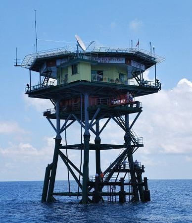
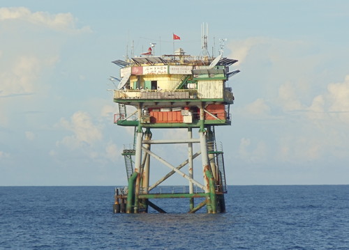
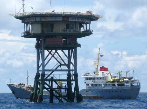
These reefs lie southwest of Spratly Island and west of Amboyna Cay. Since they are the closest reefs to the Vietnamese coast Vietnam has worked to dominate the area, building (at last count) 21 pile platform stations. Most have a standard design and are called DK1 Rigs.

Rifleman Bank Lighthouses
Rifleman Bank is a large submerged atoll roughly 80 km (50 mi) south of Spratly Island. The bank is elliptical, about 50 km (30 mi) long north to south and 20 km (13 mi) east to west. There is generally no dry land, even at low tide.
Vietnam: Ba Kè (Bombay Castle)
1995. Active; focal plane 22.5 m (74 ft); three white flashes, in a 2+1 pattern, every 12 s. 22.5 m (74 ft) tower; the light is displayed from an octagonal helipad atop a station standing on tall pilings. A photo is at right, Wikimapia has photos, Google has a satellite view. Bombay Castle is a submerged reef on the northeastern side of the Rifleman Bank, about 125 km (80 mi) east of Huyền Trân (Alexandra Bank) and the same distance west of An Bang (Amboyna Cay). The reef is named for a ship, the East India clipper Bombay Castle. Site and tower closed. ARLHS SPR-006; Admiralty F2825.19; NGA 20290.6.
Vietnam: Bãi Vũng Mây (Orleana Shoal)
Date unknown. Active; focal plane about 22 m (72 ft); white light, characteristic unknown. Approx. 22 m (72 ft) tower; the light is displayed from an octagonal helipad atop a station standing on tall pilings. Wikimapia has photos and Google has a satellite view. Located in the central portion of the Rifleman Bank. Site and tower closed. Admiralty F2825.191.
Vietnam: Bãi Đinh (Kingston Shoal)
Date unknown. Active; focal plane about 22 m (72 ft); white light, characteristic unknown. Approx. 22 m (72 ft) tower; the light is displayed from an octagonal helipad atop a station standing on tall pilings. No photo available but Google has a satellite view. Located at the southwestern end of the Rifleman Bank.Site and tower closed. Admiralty F2825.1911.

Southwest Bank Lighthouses
The Southwest Bank is actually a group of three closely spaced banks: the Prince of Wales Bank, Alexandra Bank, and Grainger Bank, located about 130 km (80 mi) west of the Rifleman Bank.

Vietnam: Phúc Tần (Prince of Wales Bank) Northeast (2)
1997 (station established 1989). Active; focal plane 23 m (75 ft); white flash every 5 s. 23 m (75 ft) tower; the light is displayed from the top of a square crew building standing on tall pilings. Wikimapia has a photo but the light is not shown in Google's satellite view. Located near the northeastern end of the reef. Site and tower closed. ARLHS SPR-005; Admiralty F2825.197; NGA 20290.2.

Ba Kè Light, Rifleman Bank
Southern Vietnam Maritime Safety photo
Vietnam: Phúc Tần (Prince of Wales Bank) Southeast
Date unknown. Active; focal plane 23 m (75 ft); white flash every 5 s. 23 m (75 ft) tower; the light is displayed from the top of a square crew building standing on tall pilings. Wikimapia has several photos and this tower is probably either the second or third. A 2021 photo shows one of the two towers with a second tower added. The light is not shown in Google's satellite view. Located near the center of the reef. Site and tower closed. Admiralty F2825.198.
Vietnam: Phúc Tần (Prince of Wales Bank) Southwest
Date unknown. Active; focal plane 23 m (75 ft); white flash every 5 s. 23 m (75 ft) tower; the light is displayed from the top of a square crew building standing on tall pilings. Wikimapia has several photos and this tower is probably either the second or third. The light is not shown in Google's satellite view. Located near the southwestern end of the reef. Site and tower closed. Admiralty F2825.199.
Vietnam: Huyền Trân (Alexandra Bank)
1994. Active; focal plane 23 m (75 ft); three white flashes, in a 2+1 pattern, every 10 s. 23 m (75 ft) tower; the light is displayed from the top of a hexagonal or octagonal keeper's house standing on tall pilings. A photo is at right, and a 2007 photo shows this tower (misidentified as Đá Lát), but the light is not shown in Google's satellite view. Huyền Trân is a submerged reef of the Alexandra Bank, about 15 km (9 mi) southeast of the Prince of Wales Bank. Site and tower closed. ARLHS SPR-001; Admiralty F2825.196; NGA 20290.4.
Vietnam: Quế Đường (Grainger Bank)
1994. Active; focal plane 23 m (75 ft); three white flashes every 10 s. 23 m (75 ft) tower; the light is displayed from the top of a hexagonal or octagonal keeper's house standing on tall pilings. An aerial view is available but the light is not shown in Google's satellite view. The Grainger Bank is about 25 km (15 mi) southwest of the Alexandra Bank at the extreme southwestern corner of the Spratlys. Site and tower closed. ARLHS SPR-003; Admiralty F2825.194; NGA 20291.2.
Huyen Tran Light
Huyền Trân Light, Alexandra Bank, August 2013
Google Maps photo posted by Trọng Tâm Đào

Prince Consort and Vanguard Bank Lighthouses
These submerged reefs are about 50 km (30 mi) southwest of the Southwest Bank reefs.

Vietnam: Bãi Phúc Nguyên (Prince Consort Bank)
Date unknown. Active; focal plane about 23 m (75 ft); two white flashes every 8 s. Approx. 23 m (75 ft) tower; the light is displayed from the top of a square crew building standing on tall pilings. Tâm Dzao's photo is at right and Wikimapia has several photos, but the light is not shown in Google's satellite view. Bãi Phúc Nguyên is a submerged reef with a depth of about 9 m (30 ft). Located about 32 km (20 mi) west of Grainger Bank at the extreme southwestern corner of the Spratlys. Site and tower closed. Admiralty F2825.1951; NGA 20291.
Vietnam: Bãi Tư Chính (Vanguard Bank) East (Tu Chin B) (?)
Date unknown. Active; focal plane 22 m (72 ft); three white flashes every 8 s. 23 m (75 ft) tower; the light is displayed from the top of a square crew building standing on tall pilings. A photo of one of the two Bãi Tư Chính platforms is available but the light is not shown in Google's satellite view. This light has been dropped from the Admiralty list. Located about 25 km (15 mi) southwest of Prince Consort Bank. Site and tower closed. ex-Admiralty F2825.193; NGA 20291.6.
Vietnam: Bãi Tư Chính (Vanguard Bank) West (Tu Chin A)
Date unknown. Active; focal plane 22 m (72 ft); two white flashes every 13 s. 23 m (75 ft) tower; the light is displayed from the top of a square crew building standing on tall pilings. Võ Hùng Phong has a 2020 photo but the light is not shown in Google's satellite view. Located about 6 km (3.5 mi) west of the East Light. Site and tower closed. Admiralty F2825.192; NGA 20291.4.
 

Bãi Phúc Nguyên Light, Prince Consort Bank, November 2020
Google Maps photo posted by Tâm Dzao
 

Information available on lost lighthouses:

Notable faux lighthouses:

Adjoining pages: North: Northern Spratly Islands | East: Southwestern Philippines | South: Labuan and Sabah | West: Southern Vietnam

Return to the Lighthouse Directory index | Ratings key

Posted April 24, 2006. Checked and revised March 1, 2024. Lighthouses: 38. Site copyright 2024 Russ Rowlett and the University of North Carolina at Chapel Hill.