Lighthouses of Suriname

The Republic of Suriname, the country known in colonial times as Dutch Guiana, is an independent nation on the north coast of South America, located between Guyana to the west and French Guiana to the east. Although it was colonized first by the British Suriname was conquered by the Netherlands in 1667 and remained a Dutch colony until it became independent in 1975. The country has two ports, Paramaribo and Nieuw Nickerie.

Remarkably, the shores of Suriname shelter the remains of three historic lightships. Thanks to Iris Klempau and Michel Forand for researching these vessels.

Dutch remains the official language in Suriname although an English-based creole is commonly used. The Dutch word for a lighthouse is vuurtoren; hoek is a cape, and rivier is a river.

Aids to navigation are maintained by the maritime authority, Maritieme Autoriteit Suriname.

ARLHS numbers are from the ARLHS World List of Lights. Admiralty numbers are from volume J of the Admiralty List of Lights & Fog Signals. U.S. NGA List numbers are from Publication 110.

General Sources
Online List of Lights - Suriname
Photos by various photographers posted by Alexander Trabas.
World of Lighthouses - Suriname
Photos by various photographers available from Lightphotos.net.
Navionics Charts
Navigation chart for Suriname.


Lightship Suriname Rivier, Fort Nieuw Amsterdam, February 2014
Flickr Creative Commons photo by David Stanley

Nieuw Nickerie Lighthouse
Nieuw Nickerie, Suriname's third largest city, is located at the northwestern corner of the country across the Corantijn River from Guyana.

Nickerie Rivier (2?)
Date unknown. Active; focal plane 90 m (295 ft); continuous red light. Approx. 85 m (279 ft) triangular communications tower painted with red and white horizontal bands. A photo shows the base of the tower and Google has a satellite view. This is an aircraft warning light that doubles as the landfall light for the Nickerie River; it has a range of about 42 km (26 mi). Located behind the Telesur television studio in downtown Nieuw Nickerie. Site open, tower closed. ARLHS SUR-005; Admiralty J6864.4; NGA 17352.

Paramaribo Area Lighthouse and Lightships
Paramaribo is the capital of Suriname and by far the largest city and port in the country; its population of about 250,000 is half the population of the entire country.

[Paramaribo Entrance]
Date unknown. Active; focal pland 7 m (23 ft); two white flashes every 15 s. 7 m (23 ft) concrete mast on a platform supported by piles. Trabas has a photo by Capt. Theo Hinrichs and Bing has an indistinct satellite view. Located midway on a groyne on the southwest side of the entrance to the Suriname River. Site open, tower closed. Admiralty J6870; NGA 17364.
Paramaribo (3?)
Date unknown (station established 1903). Removed in 2023-24 but still listed with focal plane 91 m (299 ft); red light occulting once every 2 s. This was an approx. 85 m (279 ft) triangular communications tower painted with red and white horizontal bands. Carlos Rodriguez has a photo, this is the tallest tower in a photo by Capt. Theo Hinrichs, and Google has a satellite view. This is an aircraft warning light that doubles as the landfall light for the Suriname River; it has a range of about 42 km (26 mi). The original light was a 15 m (49 ft) white skeletal tower located on the west side of the Suriname River mouth. Located behind the Telesur television studio in downtown Paramaribo. Site open, tower closed. Admiralty J6878.9; NGA 17376.
** Lightship Suriname 1 (Suriname Rivier)
1911 (station established 1858). Decommissioned in 1972. Steel lightship with a round light tower, lantern and gallery. Ship painted red. David Stanley's photo is at the top of this page, Nicholas Laughlin has a 2009 photo, Vanessa Decort has a 2006 photo, Martijn Baudoin has a 2016 street view, and Google has a satellite view. Michel Forand documented at least five light vessels known to have served the Suriname Rivier station off the entrance to Paramaribo, the national capital. This is believed to be the third. Lightphotos.net has a historic photo of the ship nearing completion in 1910 in the Netherlands. There is another historic photo (2/3 of the way down the page) of the ship, rigged as a sail-driven vessel and with its light tower taken down, leaving the Netherlands for Suriname in 1911. Lightphotos.net also has a photo of the ship on station. In recent years the ship has been righted and partially restored. Located in Fort Nieuw Amsterdam, on the east side of the Suriname River opposite Paramaribo. Site open, and it appears that visitors can walk a plank up on the deck of the vessel. Site manager: Openluchtmuseum Fort Nieuw Amsterdam. ARLHS SUR-004M.
Lightship Suriname 2 (ex U.S. LV-106/WAL-528)
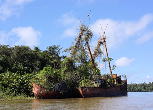
1923 (on station in Suriname from 1968). Decommissioned 1981. 40.3 m (132 ft) 2-masted steel lightship. According to the Lightship Sailors Association's page, this ship served originally as the Nantucket. After World War II it was reassigned as a relief lightvessel until 1968, when it was sold to Suriname. Presently it is an abandoned hulk beached with its sister ship LV-109 on the Suriname River across from the Overbridge Resort about 50 km (30 mi) south of Paramaribo. A photo is at right, another photo of the two ships is available, Lightphotos.net also has a photo of the two ships, and Google has a satellite view. Lightphotos.net has Jan Melchers's photo of the ship in U.S. service as the Relief and another photo of the ship on station as the Suriname. Accessible only by boat. Site open, vessel closed.
Lightship Suriname 3 (ex U.S. LV-109/WAL-531)
1923 (on station in Suriname from 1970). 40.3 m (132 ft) 2-masted steel lightship. According to the U.S. Coast Guard Historian this ship served originally for 30 years as a relief lightvessel. In 1954 it was assigned as the Savannah and it served briefly (1965-66) as the New Orleans. The subsequent history of the ship has been the source of some confusion. According to J. F. “Jay” McCarthy of the U.S. Lightship Sailors Association the ship was sold in 1967 to Uruguay, where it served for two years as the Banco Inglés. It was then sold to Suriname. It's not known when it was decomissioned. Presently it is an abandoned hulk beached with its sister ship LV-106 on the Suriname River across from the Overbridge Resort, about 50 km (30 mi) south of Paramaribo. A photo is at right, another photo of the two ships is available, Lightphotos.net also has a photo of the two ships, and a Google has a satellite view. Accessible only by boat. Site open, vessel closed.

Former U.S. Lightships 106 and 109, Suriname Rivier, July 2009
ex-Panoramio Creative Commons photo by TH22

Maroni River Lighthouse
Hoek Galibi (Maroni River) (3) (?)
Date unknown (station established 1871). Inactive since 2012; charted as a landmark. 60 m (197 ft) square skeletal tower, mounted on four concrete piers. Lighthouse painted with red and white horizontal bands. No photo available but Bing has a satellite view. However the tower is not seen in Google's satellite view; it may have fallen or been removed. The first lighthouse, a 21 m (69 ft) pyramidal tower, was replaced in 1897 by a 16 m (52 ft) hexagonal skeletal tower. Located at Hoek (Cape) Galibi on the west side of the entrance to the Maroni River, which forms the boundary between Suriname and French Guiana. Accessible only by boat. Site open, tower closed. ARLHS SUR-001; ex-Admiralty J6882; ex-NGA 17400.

Information available on lost lighthouses:

Notable faux lighthouses:

Adjoining pages: East: Guyane (French Guiana) | West: Guyana

Return to the Lighthouse Directory index | Ratings key

Posted November 30, 2006. Checked and revised June 12, 2024. Lighthouses: 3; lightships: 3. Site copyright 2024 Russ Rowlett and the University of North Carolina at Chapel Hill.