Lighthouses of Sweden: Norrköping Area

The nation of Sweden (Sverige in Swedish) is the largest country of northern Europe, occupying the entire west coast of the Baltic Sea. Along with its lengthy coast Sweden has a distinguished lighthouse history and a good record of preserving its historic lights. The Swedish Lighthouse Society (Svenska Fyrsällskapet) works actively for the preservation of the lighthouses.

Sweden is divided into 21 counties (län) and the counties are subdivided into townships and municipalities (kommuner). This page covers the coastal lighthouses of southeastern Sweden in the counties of Södermanland and Östergötland. These counties face southeastward on the Baltic Sea just to the south of the Stockholm area. Södermanland has additional lighthouses on Lake Mälaren at the northern edge of the county.

The Swedish word for a lighthouse is fyr. The front light of a range is the nedrefyr (lower light) and the rear light is the övrefyr (upper light). Ö is an island, holme is an islet, skär is a skerry (a tiny island or rocky reef), grund is a shoal or shallow, sund is a strait (often between an island and the mainland), vik is a bay, hav is a sea, udde is a headland, flod is a river, and hamn is a port or harbor.

Aids to navigation in Sweden are maintained by the Swedish Maritime Administration (Sjöfartsverket).

ARLHS numbers are from the ARLHS World List of Lights. SV numbers are from the Sjöfarsverket light list (Svenska Fyrlista) as reported by the Swedish Lighthouse Society. Admiralty numbers are from volume C of the Admiralty List of Lights & Fog Signals. U.S. NGA List numbers are from Publication 116.

General Sources
Swedish Lighthouse Society (Svenska Fyrsällskapet, SFA)
The Society is active in promoting the preservation of Swedish lighthouses.
Svenskt Fyrväsende
From the SFA web site, data and photos for many of the lighthouses.
Online Lists of Lights - Sweden
Photos by various photographers posted by Alexander Trabas.
Leuchttürme und Leuchtfeuer in Schweden - Svenska Fyrar
A large collection of photos and data posted by Erich Hartmann; text in German.
Lighthouses in Sweden
Photos by various photographers available from Wikimedia.
Sweden Lighthouses
Aerial photos posted by Marinas.com.
Lighthouse Pages from Anke and Jens - Sweden
Photos and brief accounts (in English) by two German lighthouse fans.
Fyr Vi Har Passeret (Lighthouses We've Passed)
Photos of Baltic lighthouses taken by two Danish sailors, Jette and Ole.
Schwedische Leuchttürme auf historischen Postkarten
Historic postcard views posted by Klaus Huelse.
Navionics Charts
Navigation chart for Sweden.


Hävringe Light, Oxelösund, 2013
Creative Commons photo by Jan af Geijerstam
posted by Svenska industriminnesföreningen
Lighthouses of Södermanlands Län

Trosa Lighthouses
Bokö (Julaftons Fyr) (2)
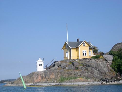
1955 (station established 1867). Active; focal plane 5 m (17 ft); white, red or green light depending on direction, 2 s on, 2 s off. 4 m (13 ft) round lantern, painted white. The original 1-story wood keeper's house, painted yellow, is a private residence. A photo is at right, a closeup photo is available, and Google has a satellite view. This lighthouse is nicknamed Julaftons Fyr (Christmas Eve Lighthouse). Located at the northern tip of Oxnö, a small island off the northwestern end of the long, slender island of Askö, about 4 km (2.5 mi) southeast of Trosa. Probably accessible only by boat. Site open, tower closed. ARLHS SWE-099; SV-430400; Admiralty C6720; NGA 8884.
Trätbådan
1940. Active; focal plane 7 m (23 ft); two flashes every 6 s, white, red or green depending on direction. 6 m (20 ft) round cylindrical concrete tower with lantern and gallery. Tower painted white, lantern green with a white roof. Google has a satellite view. Located on a small island about 4 km (2.5 mi) northeast of Langön and the same distance southwest of Askö. Accessible only by boat. Site open, tower closed. SV-434300; Admiralty C6744; NGA 8840.
Källvik
Date unknown (station established 1840). Active; focal plane 4 m (13 ft); flash every 3 s, white, red or green depending on direction. 4 m (13 ft) octagonal lantern and gallery on a white concrete pedestal; lantern painted in a red and white checkerboard pattern (unusual for Sweden). Hartmann has a page for the lighthouse, Trabas has a photo, and Google has a satellite view. Located on the northeast point of Sävö, an island between the larger island of Langön and the mainland. Site open, tower closed. SV-435500; Admiralty C6752; NGA 8836.
Julaftons Fyr
Bokö (Julaftons) Light, Trosa, August 2005
Wikimedia public domain photo by Claes
* Sävösund (2)
1941 (station established 1885). Active; focal plane 5 m (17 ft); white, red or green light depending on direction, 1.5 s on, 1.5 s off. 5 m (17 ft) post centered on a square 1-story equipment concrete equipment room. The lighthouse was "rebuilt" in 1955. Lighthouse painted white with one green horizontal band. Google has a satellite view. Located on the northern point of Sävö. Site open, tower closed. SV-434900; Admiralty C6750; NGA 8796.
Hartsö Stångskär
1940. Active; focal plane 14 m (46 ft); four flashes every 12 s, white, red or green depending on direction. 11 m (36 ft) white tower with a black horizontal band at the base. Google has a satellite view. Located on a skerry off the southern point of Hartsön, an island on the south side of Langön. Accessible only by boat. Site open, tower closed. SV-438100; Admiralty C6768; NGA 8808.
Gustaf Dalén (Oståken)
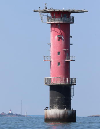
1967 (lightship station established 1927). Active; focal plane 24 m (79 ft); two white flashes every 6 s. 26 m (85 ft) round cylindrical concrete tower with two galleries and a helipad on top. Lighthouse painted red with a black band at the base. Jan Hopfinger's photo is at right and Erik Sjostedt has a photo but the lighthouse is not shown in Bing's satellite view. The former directional light was replaced by a flashing white light in 2010. The lighthouse is named for Nils Gustaf Dalén (1869-1937), a Swedish industrialist and inventor of the acetylene power system for lighthouses. Located in the Baltic about 6 km (3.5 mi) south of Langön. Accessible only by boat. Site open, tower closed. ARLHS SWE-166; SV-453600; Admiralty C6829; NGA 8608.

Eastern Nyköping Lighthouses
Lillhammarsgrund (2)
1987 (station established 1915). Active; focal plane 11 m (36 ft); flash every 3 s, white, red or green depending on direction. 12 m (39 ft) round cylindrical concrete tower with lantern and gallery. Lower half of the tower painted black, upper half white, lantern red. Bing has an indistinct satellite view. Located on a skerry about 10 km (6 mi) east of Oxelösund. Accessible only by boat. Site open, tower closed. ARLHS SWE-259; SV-455500; Admiralty C6800; NGA 8736.
Norra Lillhammarsgrund Nedre
1987. Active; focal plane 10 m (33 ft); white, red or green light depending on direction, 2 s on, 2 s off. 10 m (33 ft) round cylindrical tower with gallery. The upper half of the tower (above the gallery) is painted white with a red vertical stripe on the range line. This range guides vessels in the first leg of their approach to Nyköping. Bing has a satellite view. Located 4.3 km (2.7 mi) southeast of the rear light. Accessible only by boat. Site open, tower closed. SV-455800; Admiralty C6803; NGA 8742.

Gustaf Dalén Light, Baltic Sea, August 2020
SFA Creative Commons photo by Jan Hopfinger
Trutbådan (Norra Lillhammarsgrund Övre)
1940. Active; focal plane 16 m (52 ft); quick-flashing white light. 12 m (39 ft) tower with lantern and a red and yellow daymark. Google has a satellite view. Located about 8 km (5 mi) east northeast of Oxelösund. Accessible only by boat. Site open, tower closed. SV-456400; Admiralty C6803.1; NGA 8744.
Ledskär (3)
Date unknown (station established 1867). Active; focal plane 7 m (23 ft); white, red or green light depending on direction, 1.5 s on, 1.5 s off. 6 m (20 ft) round white lantern standing on a white concrete pier. Joakim Bernhardsson has a 2020 photo and Google has a satellite view. Located on an islet about 3 km (2 mi) northwest of Trutbäden. Accessible only by boat. Site open, tower closed. SV-451400; Admiralty C6794; NGA 8748.

Hävringe Area Lighthouses

Hävringe is a small island, the largest island in a loose chain of islands, about 10 km (6 mi) east southeast of Oxelösund. These islands are administered by the Oxelösund municipality.

Norra Kränken (2)
1979 (station established 1930). Active; focal plane 12.5 m (41 ft); three flashes every 9 s, white, red or green depending on direction. 12 m (39 ft) square cylindrical concrete tower with lantern and gallery, mounted on a conical base. Jan Hopfinger's photo is at right, Google has a satellite view. Located on a skerry about 6.5 km (4 mi) east northeast of Hävringe. Accessible only by boat. Site open, tower closed. ARLHS SWE-293; SV-455000; Admiralty C6836; NGA 8612.
Västra Korpen (2)
1979 (station established 1903). Active; focal plane 8 m (26 ft); four flashes every 12 s, white, red or green depending on direction. 7 m (23 ft) round cylindrical tower with lantern and gallery, painted white. Hartmann has a page for the lighthouse, David Nordin has a 2021 photo, Marinas.com has aerial photos, and Google has a satellite view. Located about 500 m (0.4 mi) northeast of Hävringe. Accessible only by boat. Site open, tower closed. SV-454600; Admiralty C6834; NGA 8624.

Norra Kränken Light, Hävringe, July 2011
SFA Creative Commons photo by Jan Hopfinger
Hävringe (Övre) (2)
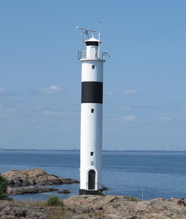
1962 (station established 1891). Active; focal plane 23 m (75 ft); white, red or green light depending on direction, 1.5 s on, 1.5 s off. 22 m (72 ft) round cylindrical tower with lantern and gallery, painted white with one narrow black horizontal band. A photo is at the top of this page, Hartmann has a page for the lighthouse, the lighthouse appears to the left of Hävringe Båk in a distant view, Trabas has a view by Pauline and Wim de Kleine, Marinas.com has aerial photos, and Google has a satellite view. Huelse has a historic postcard view of the original lighthouse. This is the rear light of a range; the front light is a small beacon 183 m (600 ft) east southeast. Jan Hopfinger has a photo showing both range lights . Located a short distance north of Hävringe Båk, at the water's edge. Accessible only by boat. Site open, tower closed. . ARLHS SWE-188; SV-454101; Admiralty C6832.1; NGA 8620.
Hävringe Båk
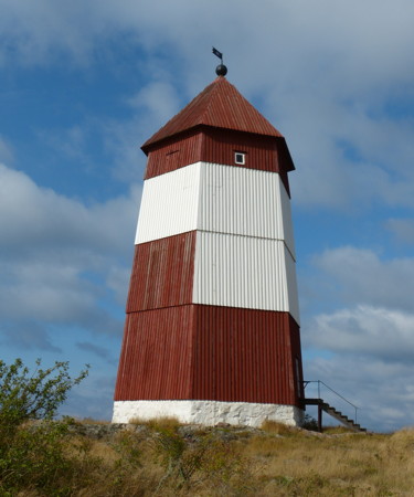
1753 (only active as a lighthouse 1879-1891). Inactive since 1891. 19 m (62 ft) hexagonal wood tower with a pyramidal roof. Tower painted red with a horizontal white daymark on the seaward side. Per-Åke Bergman's photo is at right, SFA has a photo, David Nordin has a 2021 photo, and Google has a satellite view. This historic beacon served briefly as a lighthouse with a lamp hung out a window. The light was deactivated in favor of the Hävringe range lights. Still listed as a daybeacon, the old tower is very well maintained. Accessible only by boat. Site open, tower closed. Owner/site manager: Statens Fastighetsverk (National Property Administration).
Grässkären
1900. Active; focal plane 12.5 m (41 ft); two long (2 s) flashes every 15 s, white, red or green depending on direction. 12 m (39 ft) round cylindrical concrete tower with lantern and gallery. Tower painted white, lantern green. Hartmann has a page for the lighthouse and Google has a satellite view. Located on a skerry about 8 km (5 mi) southeast of Oxelösund. Accessible only by boat. Site open, tower closed. ARLHS SWE-154; SV-461600; Admiralty C6840; NGA 8632.

Oxelösund Lighthouses
Kölhalsen (2)
1987 (station established 1957). Active; focal plane 6 m (20 ft); three flashes every 9 s, white, red or green depending on direction. 7 m (23 ft) round cylindrical concrete tower with lantern and gallery, painted white. Hartmann has a page for the lighthouse, Trabas has a very distant view and Google has a satellite view. Located on a shoal about 3 km (1.8 mi) northeast of the Oxelösund waterfront. Accessible only by boat. Site open, tower closed. SV-451800; Admiralty C6794.5; NGA 8732.
Hävringe Båk
Hävringe Båk, Oxelösund, September 2012
Wikimedia Creative Commons photo by Per-Åke Bergman
Korsholm
1921. Active; focal plane 3 m (10 ft); two flashes every 6 s, white, red or green depending on direction. 4 m (13 ft) octagonal lantern mounted on a concrete pad. Lantern painted white. Trabas has a photo and Google has a satellite view. Located on the north point of the island of Korsholm, marking the east entrance to Oxelösund harbor. Accessible only by boat. Site status unknown. SV-452800; Admiralty C6816; NGA 8724.
* Oxelösund Nedre (Oxelösund Ost)
1921. Active; focal plane 4 m (13 ft); quick-flashing light, white, red or green depending on direction. 5 m (17 ft) octagonal cylindrical tower with lantern and gallery. Entire lighthouse painted white. Hartmann has a page for the lighthouse, Trabas has a photo, Camilla Bergquist has a 2018 photo, and Google has a satellite view. The former rear light of this range has apparently been replaced by a triangular daymark on a wood post. Located at the water's edge on the south side of Oxelösund. Site open, tower closed. ARLHS SWE-308; SV-453200; Admiralty C6814; NGA 8720.
Ljungskär (2)
1927 (station established 1908). Active; focal plane 7 m (23 ft); four flashes every 12 s, white, red or green depending on direction. 7 m (23 ft) round concrete tower with lantern and gallery, painted white. Hartmann has a page for the lighthouse, Trabas has a photo, another photo is available, and Google has a satellite view. Huelse has a historic postcard view of the lighthouse with an older lantern. Located on a skerry on the northeast side of the entrance to Oxelösund, about 2.5 km (1.5 mi) southeast of the town. Accessible only by boat. Site open, tower closed. SV-463600; Admiralty C6820; NGA 8704.
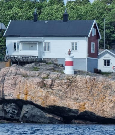
* Femörehuvud (1)
1867. Inactive; station inactive since 1972. 1-1/2 story wood keeper's house; the light was shown from a box lantern on the side of the house. In 1955 the light was moved to the small concrete tower, painted white with a red horizontal band, standing in front of the house. Also next to the original keeper's house is an older beacon on a square skeletal tower, painted black. David Lauritzen's photo is at right, Ingela Eriksson has a 2008 closeup, SFA has a page for the light station, Hartmann also has a page for the station, and Google has a satellite view. SFA has a historic photo showing the house with the lantern on its side and Huelse has a historic postcard view of the house with the skeletal beacon. The keeper's houses are available for overnight accommodations. Nearby is the Femörefortet, a nuclear-safe fortress built to protect Sweden from a possible Soviet invasion during the Cold War. Femöre is an island, connected to the mainland by a causeway or narrow isthmus, south of Oxelösund. Located at the southern tip of Femöre. Accessible by road. Site open, tower closed. Owner/site manager: Foreningen Femörefortet. . ARLHS SWE-129.

Femörehuvud Light, Oxelösund, July 2022
Google Maps photo by David Lauritzen

Southern Nyköping Lighthouses
Falkens Grund
1974. Active; focal plane 10 m (33 ft); three flashes every 9 s, white, red or green depending on direction. 11 m (36 ft) tower with lantern. Tower painted white, lantern red. Hartmann has a page for the lighthouse, Trabas has a closeup photo, and Google has a satellite view. Located on a shoal about 4 km (2.5 mi) southwest of Oxelösund. Accessible only by boat. Site open, tower closed. SV-464800; Admiralty C6845; NGA 8652.
Kungshamn Övre
1956 (station established 1905). Active; focal plane 19 m (62 ft); quick-flashing light, white, red or green depending on direction. 9 m (30 ft) round cylindrical concrete tower with lantern and gallery, painted white with two red vertical stripes. Hartmann has a page for the two range lights, Trabas has a photo and Google has a satellite view. The front light is in a small lantern. Located on the north side of the entrance to Kungshamn, about 5 km (3 mi) southwest of Femöre. Site status unknown. SV-464901; Admiralty C6846.1; NGA 8660.

Lighthouses of Östergötlands Län

Norrköping Lighthouses
Norrköping is a seaport of more than 100,000 residents. The city is located at the head of the Bråviken, a long inlet of the Baltic Sea, and at the mouth of the Motala River, the outlet for Lake Vättern and the eastern end of the Göta Canal waterway across southern Sweden.

Stora Juten (2)
1927 (station established 1886). Active; focal plane 6 m (20 ft); three flashes every 9 s, white, red or green depending on direction. 6 m (20 ft) round lantern on a short concrete pier. Lighthouse painted white with a red horizontal band around the lantern. Trabas has a photo and Google has a satellite view. Located on a skerry in the entrance to Norrköping from the Bråviken estuary. Accessible only by boat. Site open, tower closed. SV-471300; Admiralty C6902; NGA 8700.
Bosö Sten
1942. Active; focal plane 4 m (13 ft); two flashes every 6 s, white, red or green depending on direction. 4.5 m (15 ft) round lantern on a short concrete pier. Lantern painted white. Trabas has a photo and Google has a satellite view. Located on a skerry in the approach to Norrköping. Accessible only by boat. Site open, tower closed. SV-467900; Admiralty C6856; NGA 8572.
Gränsösund Nedre
Date unknown. Active; focal plane 4 m (13 ft); white, red or green light, depending on direction 2 s on, 2 s off. 4.5 m (15 ft) round lantern on a short concrete pier. Lantern painted with red and white vertical stripes; the roof is white. Trabas has a photo and Google has a satellite view. Located in the channel on the west side of Gränsö. Accessible only by boat. Site open, tower closed. Admiralty C6860; NGA 8552.
Karthällan
1958. Inactive since 1999. Approx. 8 m (26 ft) round cylindrical concrete tower with lantern and gallery. Formerly painted white, but nearly all the paint has disappeared. No photo available but Google has an indistinct satellite view. Located on a skerry about 8 km (5 mi) northeast of Arkösund. Accessible only by boat. Site open, tower closed. ARLHS SWE-214; ex-Admiralty C6853.
Viskär
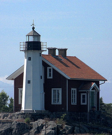
1860 (relocated here in 1894). Inactive since 1932. Approx. 9 m (30 ft) octagonal tower with lantern and gallery, attached to the seaward end of a 1-1/2 story wood keeper's house. Lighthouse painted white, lantern black; house painted red with white trim. C. Nilsson's photo is at right and Google has a satellite view. This lighthouse was originally built on Västergarns Utholme, a small island off the east coast of Gotland. Deactivated in 1887, it was relocated in 1890 to Storkläppen, an island in Kalmar. However, that station was devastated by a storm in November of the same year. The tower survived and in 1894 it was relocated a second time to Viskär. The house is now a private residence and the owners have maintained the lighthouse in excellent condition. Located on an island about 2.5 km (1.5 mi) east of Arkösund. Accessible only by boat. Site and tower closed. Site manager: private. ARLHS SWE-324.
[Arkö Båk]
1891. Never active as a lighthouse. 20 m (66 ft) square wood skeletal tower covered with steel plates. Upper half of the tower painted red, lower half white except red on the seaward face. SFA has a page for the tower, Lars Westerholm has a closeup photo, and Google has a satellite view. The metal covering was added in 1927. In 2004 the Sjöfartsverket announced that this historic daybeacon would be demolished unless a local group was interested in maintaining it. The Arkö Båks Vänner was quickly formed, and in 2006-07 the tower was restored, with the help of a historic preservation grant from the EU. Located on the southern tip of Gransö, marking the east side of the entrance to Arkösund's harbor. Site open. Owner/site manager: Arkö Båks Vänner.
Viskär Light
Viskär Light, Norrköping, July 2011
Wikimedia Creative Commons photo by C. Nilsson
Kuggviksskär (Kopparholmen Övre)
1937. Active; focal plane 13 m (43 ft); four quick flashes every 6 s, white, red or green depending on direction. 12 m (39 ft) round cylindrical tower with lantern and gallery. Entire lighthouse painted white. Hartmann has a page for the two range lights, Trabas has a photo, Marinas.com has aerial photos, and Google has a satellite view. The light guides vessels to Arkösund and is also the rear light of the Kopparholmen Range. Located on a skerry off the southeastern tip of Gränsö and about 2 km (1.2 mi) southeast of Arkösund. Accessible only by boat. Site open, tower closed. ARLHS SWE-224; SV-484500; Admiralty C6872.1; NGA 8524.
Kopparholmen (Nedre)
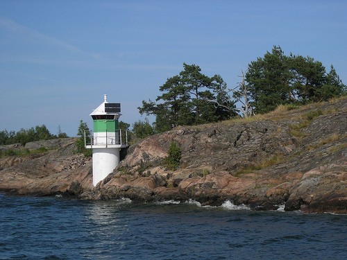
1940 (station established 1884). Active; focal plane 6 m (20 ft); white, red or green light, depending on direction, 2 s on, 2 s off. 6 m (20 ft) round tower with lantern and gallery, painted white with a green horizontal band around the lantern. A photo is at right, Hartmann has a page for the two range lights, Trabas has a photo, and Google has a satellite view. This light is the front light of a range guiding vessels northward to Arkösund; the Kuggviksskär light is the rear light. Located on the west point of Östra Kopparholmen, about 1.2 km (3/4 mi) south of the southeastern tip of Gränsö. Accessible only by boat. Site open, tower closed. SV-484600; Admiralty C6872; NGA 8520.
Norra Fällbådan
1955. Active; focal plane 16 m (52 ft); three flashes every 9 s, white, red or green depending on direction. 17 m (56 ft) round cylindrical concrete tower with lantern and gallery. Lighthouse painted black with one red horizontal band, lantern painted white. A closeup photo is available but the lighthouse is not shown in Bing's satellite view. Located in the Baltic Sea about 8 km (5 mi) east southeast of Arkösund. Accessible only by boat. Site open, tower closed. SV-483000; Admiralty C6866; NGA 8428.
Kopparholmen Lighthouse
Kopparholmen Light, Norrköping, July 2006
Flickr Creative Commons photo by Torsten
Björkskär
1924. Active; focal plane 4 m (13 ft); flash every 3 s, white, red or green depending on direction. 5 m (17 ft) rectangular wood building, painted white with one red horizontal band. The light is shown through a narrow window. Google has a satellite view. NGA misspells the name as Bjorskar. Located on a skerry in the Lönshuvudfjard about 2 km (1.2 mi) east southeast of Hummelvik. Accessible only by boat. Site open, tower closed. SV-485900; Admiralty C6876; NGA 8484.
Hackerstad (2)
1990 (station established 1945). Active; focal plane 8 m (26 ft); two flashes every 6 s, white, red or green depending on direction. 7 m (23 ft) octagonal lantern mounted on a round concrete pier. Lantern painted white with a green horizontal band. Hartmann has a page for the lighthouse, Trabas has a photo and Google has a satellite view. Located at the base of a steep headland on the north side of the Östersjön estuary. Accessible only by boat. Site open, tower closed. SV-487900; Admiralty C7004; NGA 8504.

Söderköping Lighthouses
Sandsänkan
1931. Active; focal plane 15 m (49 ft); white, red or green light, depending on direction, 2 s on, 8 s off. 16 m (52 ft) round cylindrical concrete tower with lantern and gallery. Lighthouse painted black, lantern white. A photo by Jens Magnusson is available (almost 1/3 the way down the page), Marinas.com has aerial photos, and Huelse has a historic postcard view, but the reef is only a blur in Bing's satellite view. Located in the Baltic Sea about 13 km (8 mi) due east of Yxnö. Accessible only by boat. Site open, tower closed. SV-482000; Admiralty C6978; NGA 8424.
Sandö
1940 (station established 1900). Active; focal plane 12 m (39 ft); two long (2 s) flashes every 15 s, white, red or green depending on direction. 12 m (39 ft) round tower, probably with lantern and gallery, painted white with a green horizontal band and a black band around the base. No photo available but Google has a satellite view. Located on a skerry about 1.2 km (3/4 mi) off the south coast of Fångö. Accessible only by boat. Site open, tower closed. SV-515300; Admiralty C6966; NGA 8432.
Häradskär (Häradsskär)
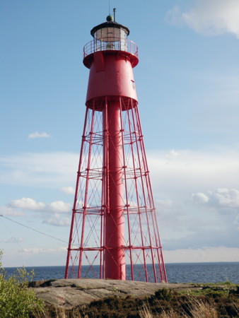
1863 (Nils Gustaf von Heidenstam). Active; focal plane 36 m (118 ft); three long (2.5 s) white flashes every 20 s. 29.5 m (96 ft) round cast iron skeletal tower with lantern, gallery, and central cylinder. Entire lighthouse painted red. The original rotating 1st order Fresnel lens was replaced in 1978 by a 3rd order lens transferred from the Dämman lighthouse (see Kalmar). Several light station buildings are available for conferences and for overnight accommodations. Jörgen Nybrolin's photo is at right, SFA has a page for the lighthouse, a 2021 photo is available, Jette and Ole have a more distant photo, Marinas.com has aerial photos, Huelse has a historic postcard view, and Google has a satellite view. This historic lighthouse, one of von Heidenstam's earliest designs, lives a lonely life far out in the Baltic. Nearby are the ruins of a daybeacon built in 1745. Located on a small island about 4 km (2.5 mi) southeast of Fångö. Accessible only by boat. Site open, tower closed. Site manager: Häradskärs Fyrplats. . ARLHS SWE-180; SV-516300; Admiralty C7022; NGA 8400.

Valdemarsvik Lighthouses
Hägerökarten
1940. Active; focal plane 10 m (33 ft); four flashes every 12 s, white, red or green depending on direction. 10 m (33 ft) round cylindrical concrete tower with lantern and gallery, painted white with a black band around the base. Jette and Ole have a good photo and Google has a satellite view. Located on a skerry about 4 km (2.5 mi) south southwest of Fångö. Accessible only by boat. Site open, tower closed. ARLHS SWE-167; SV-517000; Admiralty C7026; NGA 8396.
Häradsskars Fyr
Häradsskär Light, Baltic Sea, May 2010
Flickr Creative Commons photo by Jörgen Nybrolin
Svartbåden
1940. Active; focal plane 8 m (26 ft); three flashes every 9 s, white, red or green depending on direction. 7 m (23 ft) round tower with lantern and gallery, painted white with a narrow red band under the gallery. Google has an indistinct satellite view. Located on the eastern tip of a small island off the coast of Stora Ålö. Accessible only by boat. Site open, tower closed. SV-518200; Admiralty C7032; NGA 8388.

Information available on lost lighthouses:

Notable faux lighthouses:

Adjoining pages: North: Lake Mälaren | Northeast: Värmdö to Nynäshamn | South: Kalmar

Return to the Lighthouse Directory index | Ratings key

Posted July 16, 2007. Checked and revised December 21, 2023. Lighthouses: 37. Site copyright 2023 Russ Rowlett and the University of North Carolina at Chapel Hill.