Lighthouses of Sweden: Gotland

The Kingdom of Sweden (Sverige in Swedish) is the largest country of northern Europe, occupying the entire west coast of the Baltic Sea. Along with its lengthy coast Sweden has a distinguished lighthouse history and a good record of preserving its historic lights. The Swedish Lighthouse Society (Svenska Fyrsällskapet) works actively for the preservation of the lighthouses.

Sweden is divided into 21 counties (län) and the counties are subdivided into townships and municipalities (kommuner).The largest island in the Baltic Sea, Gotland is one of the 21 counties. The island has an area of 3140 square kilometers (1210 sq mi) and a permanent population of nearly 60,000. Located 90 km (55 mi) off the southeastern coast of the Swedish mainland, it is accessible by air or by high-speed ferries from Nynäshamn, south of Stockholm, or from Oskarshamn, north of Kalmar on the southeast coast.

The Swedish word for a lighthouse is fyr. The front light of a range is the nedrefyr (lower light) and the rear light is the övrefyr (upper light). Ö is an island, holme is an islet, skär is a skerry (a tiny island or rocky reef), sund is a strait (often between an island and the mainland), vik is a bay, hav is a sea, udde is a headland, and hamn is a harbor.

Aids to navigation in Sweden are maintained by the Swedish Maritime Administration (Sjöfartsverket).

ARLHS numbers are from the ARLHS World List of Lights. SV numbers are from the Sjöfarsverket light list (Fyrlista) as reported by the Swedish Lighthouse Society. Admiralty numbers are from volume C of the Admiralty List of Lights & Fog Signals. U.S. NGA List numbers are from Publication 116.

General Sources
Swedish Lighthouse Society (Svenska Fyrsällskapet, SFA)
The Society is active in promoting the preservation of Swedish lighthouses.
Svenskt Fyrväsende
From the SFA web site, data and photos for many of the lighthouses.
Fyrtillsyn Gotland
This association was founded in 2009 to encourage local support and maintenance of Gotland's historic lighthouses, especially those being deactivated.
Online Lists of Lights - Sweden
Photos by various photographers posted by Alexander Trabas.
Leuchttürme und Leuchtfeuer in Gotland
A large collection of photos and data posted by Erich Hartmann; text in German.
Lighthouses in Sweden
Photos by various photographers available from Wikimedia.
Lighthouse Pages from Anke and Jens - Sweden
Photos and brief accounts (in English) by two German lighthouse fans.
Lighthouses in Sweden
Aerial photos posted by Marinas.com.
Schwedische Leuchttürme auf historischen Postkarten
Historic postcard views posted by Klaus Huelse.
Navionics Charts
Navingational chart information for Gotland.
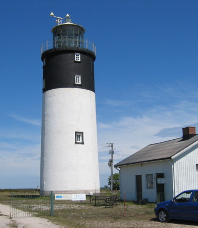
 

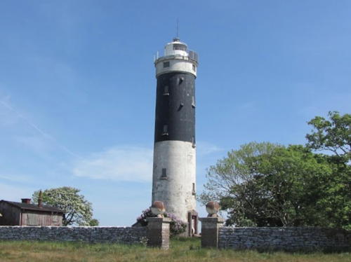
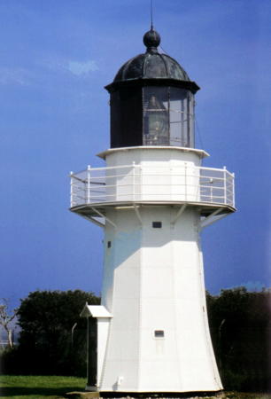
Hoburgs Fyr
Hoburg Light, Burksvik, April 2007
ex-Panoramio photo copyright Rainer Heinrichs; used by permission
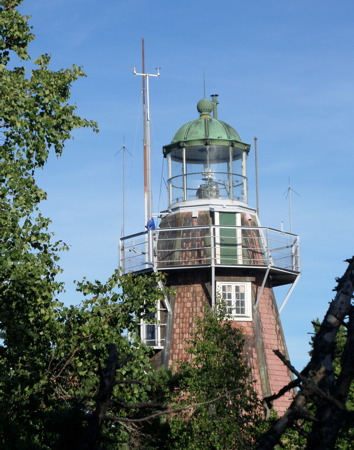
Gotska Sandön Lighthouses
Gotska Sandön is an uninhabited, roughly triangular island, about 8 km (5 mi) in diameter, located 38 km (24 mi) north of Fårö and 45 km (28 mi) north of Gotland. The entire island is a national park. Accommodations include campgrounds and rustic cabins. Boat transportation is available during the summer (weather permitting) from Fårö and from Nynäshamn, south of Stockholm.
** Gotska Sandön
1859 (Nils Gustaf von Heidenstam). Active; focal plane 42 m (138 ft); white flash every 5 s; also a continuous red light is shown in a sector to the north. 24 m (79 ft) 12-sided wood shingled iron skeletal tower with lantern and gallery. 4th order Fresnel lens in use. Lighthouse painted a reddish brown with white trim; lantern dome is greenish metallic. Per-Olof Forsberg's photo is at right, Trabas has Ina Rendtel's photo, Johnny Johansson has a good nighttime photo, a 2022 photo is available, Tanya Hart has a 2011 twilight photo, Huelse has a historic photo, and Google has a satellite view. The national park service maintains a small visitor center at the lighthouse with exhibits on the natural history of the island. This is one of two twin towers built here; they were the first lighthouses built by von Heidenstam, who became a famous lighthouse engineer. The other tower was deactivated and removed in 1903. The station was staffed until 1970. Located on a bluff at the northwestern tip of Gotska Sandön; accessible by hiking trails. Site open, tower open for climbing during the summer. ARLHS SWE-021; SV-4072; Admiralty C7150; NGA 9832.
* Kyrkudden
1913. Active; focal plane 12.5 m (41 ft); three white flashes every 9 s. 12.5 m (41 ft) round cylindrical unpainted white concrete tower with gallery; the lantern has been removed. Tanya Hart has a 2011 closeup photo and Google has an indistinct satellite view. The lantern was probably removed in 1990 when the lighthouse was renovated and converted to electric power. Located on the eastern point of the island. Site open, tower closed. ARLHS SWE-227; SV-4075; Admiralty C7156; NGA 9836.
* [Tärnudden]
1883. Inactive since 1913. This was an integral lighthouse, with a lantern mounted at one end of the keeper's house. The lighthouse was demolished after it was deactivated, but a 1-story assistant keeper's house remains. No recent photo available but Google has a satellite view. This station was closed when the Hamnudden lighthouse (next entry) was built. Located at the southeastern point of the island. Accessible by hiking trails. Site open.
* [Hamnudden (1)]
1913. Inactive since 1970. Originally a 10 m (33 ft) round white concrete tower, the lighthouse was overturned by beach erosion in 1983. Daniel Grönjord has a 2022 photo of the ruins, another photo of the ruins (fifth pair of photos on the page) is available and Google has a satellite view. Located at the southwestern tip of the island. Accessible by hiking trails. Site open, tower closed. ARLHS SWE-178.

Gotska Sandön Light, July 2016
Flickr Creative Commons photo by Per-Olof Forsberg
* Hamnudden (3?)
1970 (station established 1983). Active; focal plane about 25 m (82 ft); two white flashes every 6 s. Approx. 20 m (66 ft) triangular cylindrical skeletal tower carrying two large vertically-slatted daymarks painted white. A photo of the modern light (fifth pair of photos on the page) is available and Google has an indistinct satellite view. The NGA listing still describes the original lighthouse. Located in the woods about 50 m (165 ft) northeast of the historic ruins. Site open, tower closed. SV-4077; Admiralty C7154; NGA 9840.

Fårösund and Fårö Lighthouses
Fårö is an island just off the northeastern tip of Gotland. The island has an area of 111 km2 (43 sq mi) and is separated from Gotland by a channel called the Fårösund. Readily accessible by ferry from Gotland proper, Fårö is a popular resort. It was the home of the famous film maker Ingmar Bergman and several of his works were filmed on the island.

Svingrund
1953. Active; focal plane 11 m (36 ft); two flashes every 6 s, white, red or green depending on direction. 9.5 m (31 ft) round cylindrical concrete tower. Lighthouse painted orange red with a black band at the base. Hartmann has a page for the light, SFA also has a page, Trabas has a photo, and Google has a satellite view . Located about 1 km (0.6 mi) off the northeast point of Gotland island, marking the northern entrance to the Fårösund. Accessible only by boat. Site open, tower closed. ARLHS SWE-388; SV-4095; Admiralty C7171; NGA 9872.
Aurgrund
1935. Active; focal plane 12.5 m (41 ft); flash every 9 s, white, red or green depending on direction. 10 m (33 ft) round cylindrical concrete tower with lantern and gallery. Tower painted white, lantern and gallery black. Hartmann has a page for the light, SFA also has a page, Trabas has a photo, Marinas.com has aerial photos, and Google has a satellite view. Located on a small island on the east side of the northern entrance to the Fårösund. Accessible only by boat, but there are good views from the mainland of Fårö. Site open, tower closed. ARLHS SWE-429; SV-4092; Admiralty C7170; NGA 9868.
* Fårö
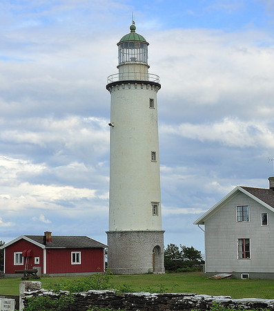
1847. Active; focal plane 31 m (102 ft); white or red light, depending on direction, 4 s on, 4 s off. 30 m (98 ft) round stone tower with lantern and gallery, mounted on round cylindrical stone base. Lighthouse painted white, except the base is unpainted; the lantern dome is gray metallic. 1-1/2 story wood keeper's house and other station buildings. The 1st order Fresnel lens (1891) was replaced in 1976 by a 4th order Fresnel lens. David Arvidsson's photo appears at right, Trabas has an excellent photo, Hartmann has a page for the lighthouse, a 2022 photo is available, Wikimedia has Jürgen Howaldt's photo, Anke and Jens have a good photo, Marinas.com has aerial photos, Huelse has a historic postcard view, and Google has a street view and a satellite view. The keeper's house was relocated here from Östergarnsholm in 1925. The light station was sold as a private residence in 1977. Located at the eastern tip of Fårö. Site and tower closed, but the lighthouse can be viewed from close by. Site manager: private. . ARLHS SWE-011; SV-4117; Admiralty C7162; NGA 9844.
Bungeör
1950. Active; focal plane 14 m (46 ft); two long flashes every 15 s, white, red or green depending on direction. 14 m (46 ft) round cylindrical concrete tower with lantern and gallery. Lighthouse painted white with one black horizontal band. Ruslan Nekrasov has a photo, Trabas has a distant view, Marinas.com has aerial photos, and Google has a satellite view. Bungeör is a small island in the center of the southern entrance to the Fårösund. Located on the southern tip of the island. Accessible only by boat; there are distant views from the Fårö side of the sound. Site status unknown. ARLHS SWE-110; SV-4120; Admiralty C7163; NGA 9852.
Fårösund Södra (2)
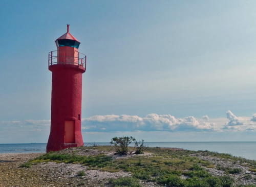
1950 (station established 1894). Active; focal plane 6 m (20 ft); flash every 3 s, white, red or green depending on direction. 7 m (23 ft) lantern and gallery atop a round concrete pier. Pier and lantern painted red; lantern roof painted white. Hartmann has a page for the light, Grigory Shmerling has a closeup photo, Trabas has a photo, Anke and Jens have a photo, and Google has a satellite view. The lighthouse warns vessels away from the Flytan shoal at the narrowest point of the Fårösund passage. Located in the Fårösund about 1.6 km (1 mi) north northwest of the Bungeör light. Accessible only by boat; there are distant views from the Fårö side of the sound. Site open, tower closed. SV-4113; Admiralty C7164; NGA 9856.
Fårös Fyr
Fårö Light, Fårö, June 2009
Flickr Creative Commons photo
by David Arvidsson

Slite Area (Northeast Coast) Lighthouses
Grauten
1911. Active; focal plane 12 m (39 ft); two flashes every 6 s, white, red or green depending on direction. 11 m (36 ft) round cylindrical concrete tower with lantern and gallery. Entire lighthouse painted bright orange. A photo by Ulf Tengzelius is at right, Trabas has a photo, B. Littmann has a 2007 photo, Hartmann has a page for the lighthouse, Marinas.com has aerial photos, and Google has a satellite view. In 2008 the Sjöfartsverket proposed to eliminate the light, but this has not occurred. Located on a small island off the northeast coast of Gotland, about 7 km (4.5 mi) southeast of Valleviken. Accessible only by boat. Site and tower closed (private property). ARLHS SWE-155; SV-4127; Admiralty C7178; NGA 9888.
Magö
1914. Active; focal plane 13 m (43 ft); three flashes every 9 s, white, red or green depending on direction. 6 m (20 ft) round cylindrical concrete tower with lantern and gallery. The tower is unpainted gray concrete; lantern painted white. Trabas has a view from the sea, SFA has a page for the lighthouse, and Google has a satellite view. Located near the south end of Magö, a small island at the southeastern entrance to Slite Hamn. Accessible only by boat. Site open, tower closed. SV-4137; Admiralty C7182; NGA 9892.
Grundet (Grunnet) (2)
1951 (station established 1914). Active; focal plane 4 m (13 ft); two flashes every 6 s, white, red or green depending on direction. 5 m (17 ft) lantern mounted on a round concrete pier. Trabas has a view from the sea, SFA has a page for the lighthouse, and Google has a satellite view. Located at the west end of Grundet, a second small island at the southeastern entrance to Slite Hamn, about 3 km (1.8 mi) north of Magö. Accessible only by boat. Site open, tower closed. SV-4139; Admiralty C7184; NGA 9896.

Grauten Light, Valleviken, July 2015
Google Maps photo
by Ulf Tengzelius

Östergarn Lighthouses
Östergarnsholm (Östergarn)
1919 (Gustav Getrén). Active; focal plane 36 m (118 ft); two long (2.5 s) flashes every 15 s. 29 m (95 ft) round cylindrical concrete tower with lantern and gallery. Lighthouse painted white with one broad black horizontal band. The keeper's house has been demolished, but some smaller light station buildings remain. Inger Karlin Larsson's photo is at right, Trabas has Ina Rendtel's photo, SFA has a page for the Östergarn lighthouses, Marinas.com has aerial photos, and Google has a satellite view. Östergarn is the eastern district of Gotland, and Östergarnsholm is an island off the east coast. Located on the eastern end of the island. Accessible only by boat. Site open, tower closed. ARLHS SWE-306; SV-4160; Admiralty C7188; NGA 9912.
Östergarnsholm Västra (1)
1817. Inactive since 1919. Approx. 18 m (59 ft) round cylindrical stone tower with gallery; lantern removed. The tower is unpainted. The 1-1/2 story stone keeper's house is in ruins. Erik Stattin has a photo, SFA has a page for the Östergarn lighthouses, Huelse has a historic postcard view of the lighthouse in service, and Google has a good satellite view. The lighthouse originally carried a coal fire. In 1849 a lantern was installed raising the height of the tower from 12 m (39 ft) to 20 m (66 ft). During this construction a light was shown from a small rubblestone tower that still stands. When the lighthouse was deactivated in 1919 its lantern was transferred to the new lighthouse (previous entry). Located at the west end of the island. Site open, tower closed.
Östergarnsholm Västra (2)
1919 (station established 1817). Active; focal plane 12 m (39 ft); two flashes every 6 s, white, red or green depending on direction. 4 m (13 ft) lantern mounted on a concrete pad. Lantern painted white. Trabas has Ina Rendtel's closeup photo, SFA has a page for the lighthouse, and Google has a satellite view. Located at the extreme western tip of the island. Site open, tower closed. SV-4163; Admiralty C7189; NGA 9916.

Östergarnsholms Light, Ljugarn, June 2016
Google Maps photo by Inger Karlin Larsson

Southeast Coast Lighthouses
* Ljugarn (2)
1992 (station established 1886). Active; focal plane 14 m (46 ft); white or red light, depending on direction, 2 s on, 2 s off. 12 m (39 ft) lantern mounted on a round cylindrical metal water tank. Access to the top of the tank is by a stairway spiraling up a post next to the structure. Entire building painted white. Trabas has an excellent closeup, SFA has a page for the lighthouse, Marinas.com has aerial photos, and Google has a street view and a satellite view. Located near the foot of the main quay in Ljugarn. Site open, tower status unknown. SV-4179; Admiralty C7196; NGA 9920.
Laus Holmar
1945. Active; focal plane 8 m (26 ft); flash every 3 s, white, red or green depending on direction. 7 m (23 ft) lantern and gallery mounted on a concrete pedestal. Entire lighthouse is white. Trabas has a photo, SFA has a page for the lighthouse, and Google has a satellite view. The Laus Holmar Nature Reserve consists of three small islands about 5 km (3 mi) southeast of Ljugarn. Located on the eastern tip of the largest island. Accessible only by boat; there is a dock at the other end of the island. Site presumably open but perhaps closed during bird nesting season; visitors can climb a ladder to the gallery. ARLHS SWE-042; SV-4185; Admiralty C7198; NGA 9924.
* När
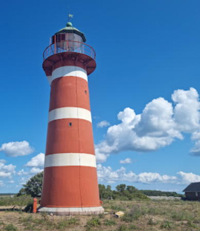
1872. Active; focal plane 21 m (69 ft); white or red light, depending on direction, 6 s on, 2 s off. 16 m (52 ft) round cast iron tower with lantern and gallery. Lighthouse painted red with narrow white horizontal bands; lantern dome is greenish metallic. 1-story keeper's house, painted white. Helmut Feder's photo is at right, Trabas has Andreas Köhler's photo, Hartmann has a page with a good photo, Anke and Jens have a page with a good photo, Marinas.com has aerial photos, Huelse has a historic postcard view, and Google has a street view and a satellite view. The light station was sold as a private residence but today it is owned by the military. Located on a promontory about 13 km (8 mi) east of Ronehamn. Site and tower closed (private property), but the lighthouse can be viewed from nearby. ARLHS SWE-049; SV-4190; Admiralty C7200; NGA 9928.
Ronehamn (2)
1963 (station established 1955). Active; focal plane 10 m (33 ft); three flashes every 9 s, white, red or green depending on direction. 11 m (36 ft) round cylindrical concrete tower with lantern and gallery. Upper half of tower painted white, lower half black. SFA has a page for the lighthouse, Trabas has a photo and Bing has a satellite view. Located in the Baltic Sea about 4 km (2.5 mi) east of Ronehamn. Accessible only by boat. Site open, tower closed. ARLHS SWE-327; SV-4205; Admiralty C7202; NGA 9932.

När Light, När, July 2023
Google Maps photo by Helmut Feder
Faludden
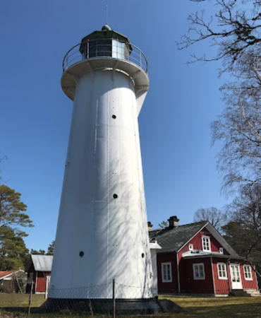
1867. Reactivated (inactive 2009-?); focal plane 11 m (36 ft); white light, 1 s on, 1 s off. 11 m (36 ft) ten-sided tapered cast iron tower with lantern and gallery. Lighthouse painted white; lantern dome is gray metallic. The 4th order Fresnel lens may still be mounted in the lantern. Esbjörn Hillberg's photo is at right, Anke and Jens have a page for the lighthouse, Trabas has Andreas Köhler's photo, Marinas.com has aerial photos, Huelse has a historic postcard view (note the daytime shroud over the lens), and Google has a satellite view. The light was deactivated on 15 April 2009; it's not known when it was restored. The current isophase light pattern was announced in 2018. Located at the end of a promontory about 15 km (9 mi) east of Burgsvik. Site and tower closed (the lighthouse is on a military reservation), but the light can be seen from fairly close by. ARLHS SWE-010; SV-4220; Admiralty C7204; ex-NGA 9952.
Heligholmen
1913. Active; focal plane 13 m (43 ft); two flashes every 6 s, white, red or green depending on direction. 9 m (30 ft) round cylindrical concrete tower with lantern and gallery. The tower is unpainted; lantern painted white. Hartmann has a page for the light, SFA also has a page, Trabas has a view from the sea, Matz Söderberg has a 2020 view from the sea, Marinas.com has aerial photos, and Google has a satellite view. Located on a small island just off the south coast of Gotland. Accessible only by boat. Site open, tower closed. ARLHS SWE-189; SV-4225; Admiralty C7206; NGA 9964.

Southwest Coast Lighthouses
*** Hoburg (Hoburgen)
1846. Active; focal plane 58 m (190 ft); white flash every 5 s. 22 m (72 ft) round stone tower with lantern and gallery. Lower 2/3 of the tower painted white, upper third black; lantern roof also painted white. Several 1-story keeper's houses. A rotating 1st order Fresnel lens (1915) is in use. Rainer Heinrichs's photo is at the top of this page, Hartmann has a page for the lighthouse, SFA also has a page, Trabas has a closeup photo, Andrey Prokopiev has a 2019 closeup, Marinas.com has aerial photos, Nicklas Jönsson has a street view from the gallery of the lighthouse (good closeup of the lens), Huelse has a historic postcard view, and Google has a good satellite view. This lighthouse marks the southwestern end of Gotland, but it is located about 2 km (1.2 mi) northeast of the cape. Site open, tower open daily mid June to mid August. The entrance to the light station is not gated but it also not marked. . ARLHS SWE-031; SV-4230; Admiralty C7210; NGA 9736.

Faludden Light, Burgsvik, April 2014
SFA Creative Commons photo by Esbjörn Hillberg
Valar (2)
1950 (station established 1889). Active; focal plane 7 m (23 ft); white, red or green light depending on direction, occulting twice every 10 s. 6 m (20 ft) round cylindrical concrete tower with half gallery, painted white; the light is shown through a slit-like window at the top of the tower. Hartmann has a page for the light, Anke and Jens have a good photo, Trabas has a photo, Jonas Jerner has a 2019 photo, and Google has a satellite view. The light marks the southern entrance to Burgsvik Hamn. Anke and Jens don't mention any difficulty in finding the light, but it does appear to be on a farm. Located about 4 km (2.5 mi) west of Burgsvik. Site possibly open, tower closed. SV-4235; Admiralty C7212; NGA 9740.
Näsrevet (2)
1951 (station established 1888). Active; focal plane 8 m (26 ft); flash every 3 s, white, red or green depending on direction. 9 m (30 ft) round solid concrete tower with lantern and gallery. Tower painted red, lantern white. SFA has a page for the light, Gunnar Britse has a photo, Trabas has a distant view, and Google has a satellite view. This light was formerly the front light of the Burgsvik harbor entrance range. Näsrevet is now the site of a large wind farm. Located on a sandbar at the end of a long, curved shoal on the north side of the entrance to Burgsvik Hamn, about 2 km (1.2 mi) from the mainland. Accessible only by boat. Site open; nothing prevents visitors from climbing to the gallery. ARLHS SWE-286; SV-4238; Admiralty C7211; NGA 9752.
* Stora Karlsö (1)
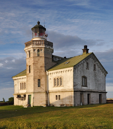
1887. Inactive since 2010. 18 m (59 ft) octagonal cylindrical stone tower with lantern and gallery, attached to the seaward side of a 2-story stone keeper's house. The 4th order Fresnel lens formerly in use may still be in the tower. Building painted white with green trim; lantern dome also painted green. The active light (focal plane 56 m (184 ft); two long flashes every 12 s, white or red depending on direction) has been moved to a mast beside the house. Helen Simonsson's photo is at right, SFA has a page for the lighthouse, Trabas has Erich Hartmann's photo, Wikimedia has several photos, Huelse has a historic postcard view, and Google has a satellite view. Stora Karlsö is an island 6 km (3.5 mi) off the southwest coast of Gotland. The island, now a nature reserve very popular with birders, is accessible by daily passenger ferry service from Klintehamn. Overnight accommodations are available in the keeper's house and in various former farm houses and other buildings on the island. Located atop a vertical cliff at the northwest corner of the island; accessible by hiking trails. Site open, tower closed. Site manager: Stora Karlsö. . ARLHS SWE-371. Active light: SV-4250; Admiralty C7224; NGA 9772.

Stora Karlsö Light, Klintehamn, June 2014
Wikimedia Creative Commons photo by Helen Simonsson

Visby Area Lighthouses
Visby, the capital of Gotland, is a historic city of about 25,000 residents and the main terminal for ferreis arriving in Gotland from the mainland.
Skansudde (Västergarn) (1)
1890. Inactive since 1936. 1-story wood keeper's house. the light was shone from a bay window at the seaward end of the house; this original lantern room has been replaced by a similar modern structure. Jessica Andersson has a 2018 photo. Located adjacent to the present lighthouse (next entry).
Skansudde (Västergarn) (2)
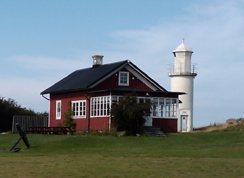
1936 (station established 1890). Inactive. Approx. 9 m (30 ft) round cylindrical concrete tower with lantern and gallery, painted white. 1-story keeper's house, painted red with white trim. Daniel Glifberg's photo is at right, SFA has a page for the lighthouse, and Google has a street view and a satellite view. The lighthouse now stands near the clubhouse of the Visby Golfklubb grounds. Located on a promontory at Västergarn about 16 km (10 mi) southwest of Visby. Site open to golfers, at least; tower closed. Site manager: Visby Golfklubb. ARLHS SWE-445; ex-SV-4274; ex-Admiralty C7232.
Visby (South Breakwater) (1) (lantern)
1867. Inactive since 1982. 3 m (10 ft) round cast iron lantern, painted white. A decorative flashing white light is displayed. A closeup photo is available and Google has a street view and a satellite view. Located in a plaza on the waterfront of Visby. Site open.
Visby (South Breakwater) (2)
1982 (station established 1867). Active; focal plane 11 m (26 ft); white, red or green light depending on direction, 2 s on, 2 off. 8.5 m (28 ft) round cylindrical concrete tower with lantern and gallery. Lighthouse painted white with a green horizontal band; the lantern is unpainted silvery metallic. Hartmann has a page for the light, SFA also has a page, Trabas has a photo, a view of the breakwater is available, and Google has a satellite view and a distant street view across the harbor. Located at the end of the south breakwater at Visby, the capital of Gotland. Site and tower closed (the breakwater is not open for walking), but the light is easily seen from ferries arriving from the mainland. SV-4283; Admiralty C7236; NGA 9796.

Skansudde Light, Visby, September 2009
Flickr Creative Commons photo by Daniel Glifberg
[Visby North (Outer) Breakwater]
1982. Active; focal plane 9 m (30 ft); quick-flashing red light. 6 m (20 ft) steel post with gallery, painted white with a broad red horizontal band. Trabas has a photo and Google has a satellite view. The light was salvaged, restored, and reinstalled after being overturned by a violent fall storm in 2002. Located at the end of the north breakwater at Visby. Accessible only by boat. Site and tower closed. SV-4286; Admiralty C7236.5; NGA 9792.

Northwest Coast Lighthouses
Stenkyrkehuk
1885. Active; focal plane 42 m (138 ft); white, red or green light depending on direction, occulting twice every 12 s. 15 m (49 ft) round steel tower with lantern and gallery. Lighthouse painted white; lantern dome is greenish metallic. Erik Cele's 2023 photo is at right, Hartmann has a page for the lighthouse, Trabas has an excellent photo, Anke and Jens have a photo, Jan Ohlström has a 2021 photo, Marinas.com has aerial photos, Huelse has a historic postcard view, and Google has a satellite view. Located on a bluff near Lickershamn on the northwestern "shoulder" of Gotland. Site and tower closed (private property). ARLHS SWE-062; SV-4294; Admiralty C7246; NGA 9816.
* Hallshuk (1)
1891. Inactive since 1930. 1-story wood keeper's house; the light was shown through a bay window on the long side of the house. The light was moved to an octagonal lantern in 1930.
* [Hallshuk (3)]
1957 (station established 1891). Active; focal plane 32.5 m (107 ft); four long (2 s) flashes every 20 s, white, red or green depending on direction. 3 m (10 ft) round lantern standing on a small concrete pad. The 1-story keeper's house was originally a pilot station and later served as a signal station. Hartmann has a page for the light, Trabas has a closeup, Andreas Köhler has a 2022 closeup, Anke and Jens have a page with photos, Marinas.com has aerial photos, and Google has a satellite view. The original lighthouse was replaced in 1930 by an octagonal lantern on a concrete base. Located atop a vertical cliff on a promontory on the north coast of Gotland, marking the entrance to Kappelshamn. The area is a military installation, but it is open to the public except when training is in progress. Anke and Jens were able to visit the site. Site usually open, tower closed. ARLHS SWE-026; SV-4080; Admiralty C7250; NGA 9828.
 

Stenkyrkehuk Light, Lickershamn, April 2023
Google Maps photo by Erik Cele
 

Information available on lost lighthouses:

Notable faux lighthouses:

Adjoining pages: North: Nynäshamn Area | Southwest: Öland | West: Kalmar

Return to the Lighthouse Directory index | Ratings key

Posted June 2007. Checked and revised January 8, 2024. Lighthouses: 29. Site copyright 2024 Russ Rowlett and the University of North Carolina at Chapel Hill.