Lighthouses of Sweden: Lake Vättern and the Göta Canal

The Kingdom of Sweden (Sverige in Swedish) is the largest country of northern Europe, occupying the entire west coast of the Baltic Sea. Along with its lengthy coast Sweden has a distinguished lighthouse history and a good record of preserving its historic lights. The Swedish Lighthouse Society (Svenska Fyrsällskapet) works actively for the preservation of the lighthouses.

Sweden is divided into 21 counties (län) and the counties are subdivided into townships and municipalities (kommuner). This page includes the lighthouses of Lake Vättern in southern Sweden. Lake Vättern, Europe's sixth largest lake, is 130 km (81 mi) long but no more than about 31 km (20 mi) wide. The Göta Canal, part of an inland waterway that connects Göteborg on the Kattegat to Mem on the Baltic Sea, crosses Lake Vättern on its way from the larger Lake Vänern to the Baltic. There is some commercial traffic on the canal but mostly it is used by recreational vessels.

Four of the 21 counties of Sweden border the lake. The listing here is counterclockwise starting in Örebro county at the north end of the lake.

The Swedish word for a lighthouse is fyr. The front light of a range is the nedrefyr (lower light) and the rear light is the övrefyr (upper light). Ö is an island, holme is an islet, skär is a skerry (a tiny island or rocky reef), grund is a shoal or shallow, sund is a strait (often between an island and the mainland), vik is a bay, hav is a sea, udde is a headland, flod is a river, and hamn is a port or harbor.

Aids to navigation in Sweden are maintained by the Swedish Maritime Administration (Sjöfartsverket).

ARLHS numbers are from the ARLHS World List of Lights. SV numbers are from the Sjöfarsverket light list (Svenska Fyrlista) as reported by the Swedish Lighthouse Society. Former Admiralty numbers are from volume C of the Admiralty List of Lights & Fog Signals (the Admiralty dropped these lights from its listings in 2014). The lighthouses of the lake are not included on the NGA List.

General Sources
Swedish Lighthouse Society (Svenska Fyrsällskapet, SFA)
The Society is active in promoting the preservation of Swedish lighthouses.
Svenskt Fyrväsende
From the SFA web site, data and photos for many Swedish lighthouses.
Leuchttürme und Leuchtfeuer am Vättern
A large collection of photos and data posted by Erich Hartmann; text in German.
Online List of Lights - Sweden
Photos by various photographers posted by Alexander Trabas.
Leuchttürme in Schweden
Photos by Andreas Köhler.
Lighthouse Pages from Anke and Jens - Sweden
Photos and brief accounts (in English) by two German lighthouse fans.
Schwedische Leuchttürme auf historischen Postkarten
Historic postcard views posted by Klaus Huelse.
Navionics Charts
Navigational chart for Lake Vättern.


Vanäs Light, Karlsborg, December 2023
Instagram photo by utflyktermedmera
Örebros Län Lighthouses

North Shore Lighthouses
Bastedalen (2)
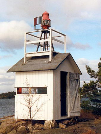
1953 (station established 1900). Active; focal plane about 7 m (23 ft); two flashes every 6 s, white, red or green depending on direction. 4 m (13 ft) light displayed from a platform on the roof of a square 1-story wood building. Building painted white. It appears that the lights were formerly displayed through a slit-like window in the building. Trabas has a closeup photo, Hartmann has a page for the lighthouse, and another photo is available, but the small light isn't seen clearly in Google's satellite view. This light stands at the northern end of the open waters of the lake, marking the entrance to narrow passages leading to Hammar and Askersund. Located about 3 km (1.8 mi) southwest of Hammar. Site status unknown. SV-5025; ex-Admiralty C6952.27.
Storsundsholmen (Dimestorp)
1978. Active; focal plane 8 m (26 ft); white flash every 1.5 s. 5 m (23 ft) square pyramidal stone tower, painted white. A photo is available and Google has an indistinct satellite view. Located on an island just off the northwestern shore of the lake, on the west side of the passage leading to Olshammar. Accessible only by boat. Site open, tower closed. SV-5020; ex-Admiralty C6952.2.
Orrholmen (2)
1929 (station established 1906). Active; focal plane 5 m (17 ft); flash every 5 s, red, green or white depending on direction. 4 m (13 ft) round lantern, painted white. Google has a distant satellite view. The light guides vessels in a narrow channel between the islands of Lilla Rocknen and Stora Rocknen. Located about 30 km (19 mi) northeast of Karlsborg. Accessible only by boat. Site open, tower closed. SV-5015; ex-Admiralty C6952.15.

Västra Götalands Län Lighthouses

West Shore Lighthouses
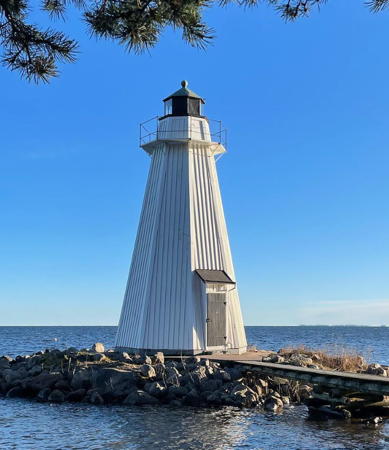
* Vanäs (Vanäs Udde, Karlsborg) (2)
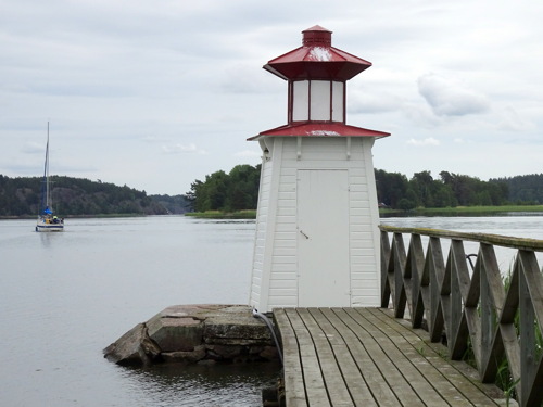
1892 (station established 1864). Active; focal plane about 10 m (33 ft); three flashes every 9 s, white, red or green depending on direction. 11.5 m (37 ft) octagonal pyramidal wood tower with lantern and gallery, painted white; lantern roof painted green. A photo is at the top of the page, Hartmann has a page for the light, SFA also has a page, Trabas has a closeup photo, another photo is available, Köhler has a photo, Huelse has a historic postcard view, and Google has a satellite view. This light guides vessels westbound on the Göta Canal across the lake into Karlsborg. Located on a promontory on the east side of Karlsborg. Site open, tower closed. . ARLHS SWE-415; SV-4995; ex-Admiralty C6953.2.

Bastedalen Light, Hammar, October 2016
SFA Creative Commons photo by Esbjörn Hillberg
Broskjutvarnings (Bro)
1990. Active; focal plane 6 m (20 ft); very quick flashing white light. 4 m (13 ft) square unpainted wood enclosure standing on wood legs. Hartmann has a page for the light, Trabas has a photo, Köhler has a photo, and Google has a satellite view. Located in a lakeside residential neighborhhod just south of the Karlsborg airport. Site and tower closed (private property). SV-4992; ex-Admiralty C6953.
Kråk
1968. Active; focal plane 34 m (112 ft); very quick flashing white light. Approx. 29 m (95 ft) square cylindrical skeletal tower with square central cylinder supporting a 2-story octagonal control room. Entire structure is gray. Hartmann has a page for the light, Trabas has a good photo, and Google has a satellite view. This is a watch tower at a military base. Located about 8 km (5 mi) southwest of Karlsborg. Site and tower closed. SV-4991; ex-Admiralty C6952.9.
Enebågsudde
Date unknown (station established 1907). Active; focal plane 6 m (20 ft); flash every 6 s, white, red or green depending on direction. 7 m (23 ft) square tower with lantern and gallery, painted white. Hartmann has a page for the light, SFA also has a page, Trabas has a closeup photo, and Google has a satellite view. Located on a promontory about 13 km (8 mi) south of Karlsborg. Site status unknown; the road to the lighthouse is gated. SV-4990; ex-Admiralty C6952.6.
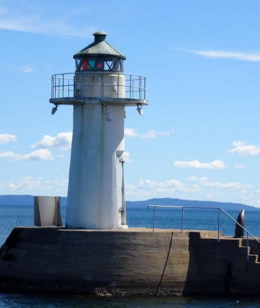
* Hjo Norra (2)
Date unknown (station established 1897). Active; focal plane about 9 m (30 ft); quick-flashing light, white, red or green depending on direction. Approx. 7 m (23 ft) round concrete tower with lantern and gallery, painted white. Köhler's photo is at right, Hartmann has a page for the light, Trabas has a fine photo, a photo showing both lighthouses is available, Wikimedia has a photo, Huelse has a historic postcard view, Jann Lipka has a street view from the other end of the breakwater, and Google has a satellite view. Located at the north end of the detached breakwater protecting the harbor of Hjo. Site open, tower closed. . ARLHS SWE-190; SV-5041; ex-Admiralty C6952.8.
* Hjo Södra (2)
Date unknown (station established 1897). Active; focal plane about 9 m (30 ft); two flashes every 6 s, white, red or green depending on direction. Approx. 7 m (23 ft) round concrete tower with lantern and gallery, painted white. SFA has a page for the two lighthouses, Trabas has a photo, Köhler has a photo, Jann Lipka has a closeup street view, and Google has a satellite view. Huelse has a historic postcard view of the original lighthouse. Located at the south end of the detached breakwater protecting the harbor of Hjo. Site open, tower closed. ARLHS SWE-191; SV-5042; ex-Admiralty C6952.81.

Hjo Norra Light, Hjo, June 2017
Gooogle Maps photo by Andreas Köhler

Jönköpings Län Lighthouses

South Shore Lighthouses
* Domsand
1983. Active; focal plane 7 m (23 ft); one long flash every 10 s, white, red or green depending on direction. 6 m (20 ft) post light centered on an unusual dome-shaped equipment shelter. Lighthouse painted white. Hartmann has a page for the light, Dick Wåhlin has a photo, Köhler has a photo, and Google has a satellite view. Located on the north breakwater of the Domsand yacht harbor, on the north side of Bankeryd near the southwestern end of the lake. Accessible by walking the pier. Site open, tower closed. SV-5069; ex-Admiralty C6951.2.
* Gränna (2)
1937 (station established 1898). Active; focal plane 7 m (23 ft); four white flashes every 12 s. Approx. 7 m (23 ft) round concrete tower with lantern and gallery. Lighthouse painted white with black trim, lantern roof green. Mikael Good's photo is at right, Hartmann has a page for the light, SFA also has a page, Köhler has a closeup photo, Josep Martí has a twilight photo, Francesco Bellotti has a street view across the harbor, and Google has an indistinct satellite view. Located on a pier inside the harbor of Gränna. New breakwater moles have been built on both the north and south sides of the harbor and Trabas has a photo of the light at the end of the new south breakwater. Accesssible by walking the mole, and there's also a fine view from ferries departing for the island of Visingsö. Site open, tower closed. ARLHS SWE-153; SV-5067; ex-Admiralty C6952.88.

Visingsö Lighthouses
Visingsö is a narrow island about 14 km (8.7 mi) long in the center of Lake Vättern. The island is accessible by ferry from Gränna.

*
Visingsö Södra Udde
1900. Active; focal plane about 11 m (36 ft); white flash every 6 s. Approx. 6 m (20 ft) round stone tower with lantern and gallery, painted white. SFA has a page for the lighthouse, Hartmann also has a page for the light, Monika Baillot has a 2021 photo, and Google has a satellite view. The island is accessible by ferry from Gränna. Located on the southwestern tip of the island. Site open, tower closed. ARLHS SWE-423 SV-5062; ex-Admiralty C6952.87.

Gränna Light, Gränna, February 2018
Google Maps photo by Mikael Good
* Visingsö Norra Udde
1900. Active; focal plane about 8 m (26 ft); two white flashes every 6 s. Approx. 5 m (17 ft) round stone tower with lantern and gallery, painted white. SFA has a page for the lighthouse, Wojciech Kołodziejczyk has a 2023 photo, Trabas has a distant view, and Google has a satellite view. Located on the northeastern tip of the island. Site open, tower closed. ARLHS SWE-422; SV-5052; ex-Admiralty C6952.85.

Östergötalands Län Lighthouses

East Shore Lighthouses
* Hästholmen
1897. Active; focal plane 15 m (49 ft); continuous white light. 9 m (30 ft) hexagonal pyramidal wood tower with lantern and gallery, mounted on a 1-story hexagonal wood base. Above the base, the tower appears to be covered with iron sheets. Entire lighthouse painted white. Kerstin Hermann's photo is at right, Hartmann has a page for the light, SFA also has a page, Trabas has a photo, Köhler has a photo, another good closeup photo is available, Tomas Hellberg has a street view, and Google has a satellite view. This historic lighthouse is located on the tip of a peninsula sheltering the west side of the harbor of Hästholmen. Site open, tower closed. . ARLHS SWE-186; SV-5047; ex-Admiralty C6952.45.
Jungfrun
1947. Active; focal plane 17.5 m (57 ft); four white flashes every 12 s. Approx. 6 m (20 ft) round cylindrical concrete tower with lantern and gallery, painted white. Trabas has a view from the lake and Google has a satellite view. Located on an island about 4 km (2.5 mi) off the east side of the lake and 8 km (5 mi) west of Vadstena. Accessible only by boat. Site open, tower closed. SV-4985; ex-Admiralty C6952.3.
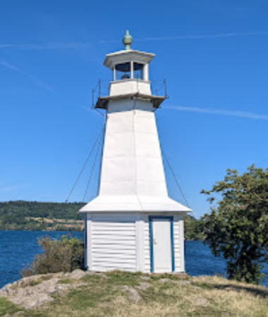
* Vadstena Mole
1889. Active; focal plane 7.5 m (25 ft); three white flashes every 9 s. 7 m (23 ft) octagonal pyramidal wood tower with lantern. Lighthouse painted white; the lantern roof is greenish metallic. SFA has a page for the lighthouse, Henry Law has a 2008 photo, a 2022 photo is available, Trabas also has a good photo, Huelse has a historic postcard view, Uwe Bücher has a closeup street view, and Google has a satellite view. Located at the end of the mole at Vadstena. Accessible by walking the pier. Site open, tower closed. . ARLHS SWE-410; SV-4975; ex-Admiralty C6951.8.
Fjuk (3)
1910 (station established 1852). Active; focal plane 18.5 m (61 ft); one long white flash every 8 s. 9.5 m (31 ft) round cylindrical concrete tower with lantern and gallery, painted white. Patrik Lindblom has a good closeup photo, Trabas has a distant view from the lake, and Google has a satellite view. This lighthouse is near the midpoint of the crossing of the lake (from Karlsborg to Motala) by vessels following the Göta Canal. The original lighthouse was replaced in 1889 by a lantern mounted on the keeper's house. The present lighthouse was one of the first in Sweden to be built for automated operation. Located on a small island about 12 km (7.5 mi) west of Motala and 8 km (5 mi) northwest of Vadstena. Accessible only by boat. Site open, tower closed. ARLHS SWE-134; SV-4980; ex-Admiralty C6952.

Hästholmen Light, Hästholmen, August 2022
Google Maps photo by Kerstin Hermann
Klubbudden
1942. Active; focal plane 27 m (89 ft); very quick flashing white light. 26 m (85 ft) square cylindrical concrete tower rising from one end of a 1-story concrete building. Hartmann has a page for the lighthouse, Trabas has a photo, and Google has a satellite view. This light guides eastbound vessels approaching Motala and the Göta Canal from Lake Vättern. Located about 400 m (1/4 mi) off a promontory on the west side of Motala. Accessible only by boat. Site open, tower closed. SV-4970; ex-Admiralty C6951.7.

Göta Canal Lighthouses
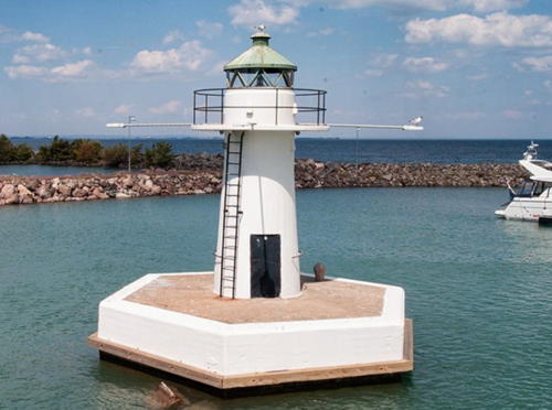
Hundsten
1929 (rebuilt 1984). Active; focal plane 4 m (13 ft); flash every 3 s, red, green or white depending on direction. 4 m (13 ft) octagonal lantern mounted on a concrete pier. Lantern painted white. Hartmann has a page with a 2022 photo, Trabas has a photo, and Google has a street view and a satellite view. This leading light guides eastbound vessels entering the Göta Canal from Lake Vättern. Located just offshore from the Solviksgaten neighborhood, on the north side of the entrance to Motala harbor. Accessible only by boat, but visible from shore. Site open, tower closed. SV-4959; ex-Admiralty C6951.65.
Borensberg
1898. Active; focal plane about 6 m (20 ft); white flash every 4 s. 5 m (17 ft) square tower, painted white; lantern removed. Trabas has a closeup photo and Google has a satellite view. Located at the end of the jetty on the west side of the eastbound entrance to the canal from Lake Boren, near Borensberg. Accessible by walking the pier at the end of a trail along the canal. Site open, tower closed. ex-Admiralty C6951.5.
Norsholm
1898. Inactive. 5 m (17 ft) square tower, painted white; lantern removed. Andreas Köhler has a closeup photo, light is at the left edge of a photo taken across the canal, an aerial view is available, and Google has a satellite view. Buoys replaced the light. Located on the south side of the eastbound entrance to the canal from Lake Roxen, on the west side of Norsholm. Site open, tower closed.
* Söderköping (Mem)
1898. Active; focal plane 7 m (23 ft); flash every 3 s, red, green or white depending on direction. 7 m (23 ft) square wood tower with a small lantern, painted white; lantern roof is red. Köhler's closeup photo is at right, a 2022 photo and another closeup are available, G. Baetje has a view from the canal, Marinas.com has aerial photos, and Google has a satellite view. Located at the end of a short pier on the north side of the westbound canal entrance at Mem. Accessible by walking the pier. Site open, tower closed. SV-4892; ex-Admiralty C7010; NGA 8516.

Söderköping Light, Mem, June 2017
ex-Google Plus photo by Andreas Köhler

Information available on lost lighthouses:

Notable faux lighthouses:

Adjoining pages: East: Nyköping Area | West: Lake Vänern

Return to the Lighthouse Directory index | Ratings key

Posted September 3, 2007. Checked and revised December 31, 2023. Lighthouses; 22. Site copyright 2024 Russ Rowlett and the University of North Carolina at Chapel Hill.