Lighthouses of Syria

The nation of Syria (Sūriyā in Arabic, officially the Syrian Arab Republic) has about 150 km (90 mi) of coastline facing west on the Mediterranean Sea between Turkey and Lebanon. Like all of the Middle East, Syria was part of the Ottoman (Turkish) Empire for four centuries until World War I. After that war it became part of the French Mandate for Syria and the Lebanon. The French detached Lebanon from Syria and created the Lebanese Republic in 1926. Both Syria and Lebanon became independent in 1943, during World War II.

Under the French Mandate the coastal region of Syria was governed from 1920 to 1936 as the Alawite State because the majority of the population in the coastal districts were followers of the Alawite sect of Shi'a Islam. This is still the case, and as a result the coastal governorates of Tartus and Latakia have remained loyal to the Alawite-led central government of Bashar al-Assad. Under central government control the coast has been generally peaceful during the ongoing Syrian Civil War that began in 2011. Russia, an ally of the Assad government, has a major naval base at Tartus and a major air base near Latakia.

Lighthouses in Syria are operated by the Ports Affairs Department of the General Directorate of Syrian Ports, an agency of the Ministry of Transport.

The Arabic word for a lighthouse is mnarh or manara (منارة). Ra's is the word for a cape or headland, and jazirat is an island.

ARLHS numbers are from the ARLHS World List of Lights. Admiralty numbers are from volume N of the Admiralty List of Lights & Fog Signals. U.S. NGA List numbers are from Publication 113.

General Sources
Online List of Lights - Syria
Photos by various photographers posted by Alexander Trabas.
World of Lighthouses - Syria
Photos by various photographers available from Lightphotos.net.
GPSNauticalCharts
Navigational chart for Syria.
Navionics Charts
Navigational chart for Syria.


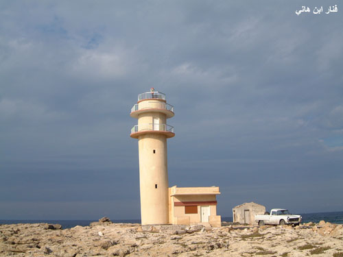
Ra's ibn Hani Light, Latakia
General Directorate of Syrian Ports photo
Tartus Governorate Lighthouses
Tartus is an ancient seaport known as Antaradus in classical times. The modern city has a population of roughly 120,000.
* Arwad (Jazirat Arwad, Île Rouad, Ruad Island) (3?)
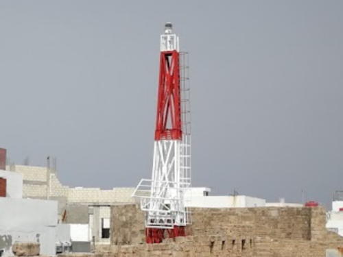
Date unknown (station established 1864). Active; focal plane about 24 m (79 ft); white flash every 5 s. Approx. 11 m (36 ft) square skeletal tower, upper half painted red and lower half white, mounted atop a 4-story fortress. Hareth Ahmed has the 2018 photo seen at right, the light is atop the fortress on the right side of a drone view, and Google has a satellite view of the fort. Michel Forand has a 1922 photo showing the original lighthouse and Wikipedia has Jacky Lee's 2007 photo of the second (?) light on a short black skeletal tower. Arwad (originally known as Aradus) is a roughly circular island 3 km (2 mi) southeast of the waterfront of Tartus. The fortress was originally built in the 12th century by crusaders, the Knights Templar, who held it until 1303. Subsequently it was rebuilt by the Ottomans. Passenger ferry service to the island is available. Site apparently open, tower closed. ARLHS SYR-003; Admiralty N5924; NGA 21044.
Tartus West Breakwater
Date unknown. Active; focal plane unknown; green flash every 4 s. Approx. 10 m (33 ft) round concrete tower with gallery, painted with green and white horizontal bands. No photo available but Google has a satellite view. Located at the end of the west (really the south) breakwater of Tartus. Site status unknown. Admiralty N5923.7; NGA 21039.
Baniyas (Banias)
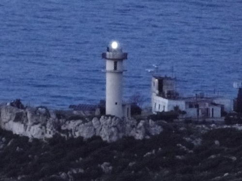
Date unknown. Active; focal plane 98 m (321 ft); three flashes every 17 s, white or red depending in direction. 11 m (36 ft) white tower with gallery, attached to a 2-story white station building. No closeup photo available. The Directorate of Ports has a distant photo, Trabas also has a distant photo, Hicham Hasan has a 2013 photo, and Google has a satellite view of the station. Located on a hill behind a headland about 5 km (3 mi) south southwest of Baniyas. Site and tower closed. ARLHS SYR-002; Admiralty N5923.5; NGA 21032.

Arwad Light, Tartus, October 2018
Google Maps photo by Hareth Ahmed

Latakia Governorate Lighthouses
Latakia is the principal port and fourth largest city of Syria. Its population before the Civil War was about 385,000, but it has increased as refugees from war-torn areas have arrived in and around the city.
El Burj (Al Burj)
1864 (?). Almost certianly inactive but listed with focal plane 22 m (72 ft); two white flashes every 9 s. 5 m (16 ft) round white stone tower, now surrounded by trees. Trabas has Capt. Peter Mosselberger's distant view, the tower is behind the tree at the lower right edge of Hicham Hasan's 2012 photo, Abd Alrhman al-Haj Hasn has a distant 2023 view, a historic photo is available, and Google has a satellite view. This appears to be the original tower, described in 1904 as "White stone tower on old castle, El Burj islet." The El Burj castle overlooks a small boat harbor, an inlet deep inside the commercial harbor. Located on the north side of the inlet. Site status unknown. ARLHS SYR-001; Admiralty N5921.4; NGA 21006.
* Latakia (Lattakia) Range Rear
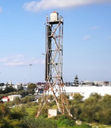
Date unknown. Active; focal plane unknown; two red flashes every 5 s. Approx. 30 m (98 ft) square skeletal tower with gallery and a round metal lantern. Lantern roof painted red. The tower also carries a large slatted daymark, coloring unknown. Bashar Saleh has the 2018 photo seen at right and Google has an indistinct satellite view. Google also has a satellite view of the front light on a tall mast on the waterfront of the city's container terminal. Located near the waterfront in the midst of the commercial harbor of Latakia. Site may be closed, but the lighthouse is close to a major through street. Tower closed. Admiralty N5921.51; NGA 21005.1.
* Ra's ibn-Hani (3?)
Date unknown (station established 1864). Active; focal plane 18 m (59 ft); white flash every 6 s. 17 m (56 ft) round cylindrical concrete tower with double gallery, attached to a 1-story concrete equipment building. Entire lighthouse painted a light buff color. A photo is at the top of this page and Google has a satellite view. The first light (1864) was described as a white stone tower. Located on the point of Ra's ibn-Hani, about 12 km (7.5 mi) north of Lattakia. Site status unknown, but the lack of photos of the cape suggests that the area is closed. ARLHS SYR-006; Admiralty N5920; NGA 20996.
Ra's al-Fasuri
Date unknown. Active; focal plane 74 m (243 ft); three quick white flashes every 5 s. White tower with black bands. No photo available but Google has an indistinct satellite view. Ra's al-Fasuri is a blunt headland about 25 km (15 mi) north of Lattakia; much of the headland has been removed by a large quarrying operation. Site status unknown. ARLHS SYR-005; Admiralty N5919.4; NGA 20992.
Ra's al-Basit (Ras al-Baset)
Date unknown. Active; focal plane 75 m (246 ft); white flash every 4 s. 12 m (39 ft) round cylindrical white concrete tower with gallery. 1-story keeper's house with a square tower at one corner. A 2010 photo is available, Hicham Hasan has a very distant view of the station, and Google has a satellite view. Ra's al-Basit is a sharp, mountainous promontory about 15 km (9 mi) southwest of the Turkish border. The south side of the cape shelters a popular beach resort. Located at the tip of the cape. Site status unknown. ARLHS SYR-004; Admiralty N5919; NGA 20988.

Latakia Range Rear Light, Latakia, January 2018
Google Maps photo by Bashar Saleh

Information available on lost lighthouses:

Notable faux lighthouses:

Adjoining pages: North: Southern Turkey | South: Lebanon

Return to the Lighthouse Directory index | Ratings key

Posted May 21, 2007. Checked and revised May 15, 2024 Lighthouses: 8. Site copyright 2024 Russ Rowlett and the University of North Carolina at Chapel Hill.