Lighthouses of Lebanon

The Republic of Lebanon (Lubnān in Arabic) is a small country at the eastern end of the Mediterranean Sea, bordered by Syria to the north and east and by Israel to the south. Like all of the Middle East, Lebanon was part of the Ottoman (Turkish) Empire for four centuries until World War I. After that war it became part of the French Mandate for Syria and the Lebanon. The French detached Lebanon from Syria and created the Lebanese Republic in 1926. The country became independent in 1943, during World War II.

Lebanon was torn by a bitter civil war from 1975 to 1990. In July 2006 war broke out on the Israeli frontier and during the five weeks of heavy fighting both of Beirut's lighthouses were damaged. Currently there is again fighting on the southern border between Israel and the Hezbollah Islamist group.

Lebanon is divided into nine governorates (muḥāfaẓāt), including one for the capital city of Beirut.

Aids to navigation in Lebanon are the responsibility of the Directorate General of Land and Maritime Transport.

Arabic is the official language of Lebanon. The Arabic word for a lighthouse is mnarh or manara (منارة). Ra's is a cape, jaza'ir or jazirat is an island, shi'b is a reef, shira' is a bay, and marfa is a harbor. Transliteration of Arabic to Latin characters can be done in many ways, so alternate spellings are common.

Lebanese lighthouses are maintained by the Directorate General of Land and Maritime Transport.

ARLHS numbers are from the ARLHS World List of Lights. Admiralty numbers are from volume N of the Admiralty List of Lights & Fog Signals. U.S. NGA List numbers are from Publication 113.

General Sources
Online List of Lights - Lebanon
Photos by various photographers posted by Alexander Trabas.
Lighthouses in Lebanon
Photos by various photographers available from Wikimedia.
World of Lighthouses - Lebanon
Photos by various photographers available from Lightphotos.net.
Leuchtürme Asiens auf historischen Postkarten
Historic postcard views posted by Klaus Huelse.
GPSNauticalCharts
Navigational chart information for Lebanon.
Navionics Charts
Navigational chart for Lebanon.


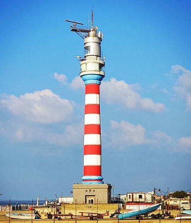
Manara Lighthouse, Beirut, March 2019
Google Maps photo by Syed Rashid Abrar

South Governorate Lighthouses
Sur (Sour, Tyre) (2)
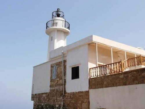
Around 1912(?) (station established 1866). Active; focal plane 15 m (49 ft); three white flashes every 12 s. 6 m (20 ft) round concrete tower with gallery and four ribs, mounted atop a 2-story masonry building. Lighthouse painted white. The building is described as being on an "old fort" in NGA. A 2022 photo is at right, Roman Deckert has a 2016 photo, Hubert Marcueyz has posted a closeup photo, Trabas has another closeup, Moustafa Omar has a 2018 photo, Marie Noëlle Taine also has a photo, François Nour has a street view, and Google has an indistinct satellite view. Although the date of this lighthouse is not known, it appears to be a twin of the 1912 lighthouse at Akko (Acre) in Israel. Sur, the ancient Phoenicean port of Tyre, is located on a rocky peninsula jutting into the Mediterranean Sea. The lighthouse is located at the extreme northwestern tip of the peninsula. Site open, tower closed. ARLHS LEB-003; Admiralty N5942; NGA 21192.
Az Zahrani Power Station
Date unknown. Active; focal plane 56 m (184 ft); red flash every 2 s. Described by NGA as a "red and white pylon," the light must be mounted on one of the two tall smokestacks of the Zahrani Power Station. The stacks are painted with red and white horizontal bands. A photo is available and Google has a satellite view. The Zahrani plant burns liquefied natural gas. Located at the power plant about 8 km (5 mi) south of Saida. Site and tower closed. Admiralty N5941; NGA 21152.
Saida (Az Zirah, Zeeri, Sidon (3))
Date unknown (1930s?). Apparently inactive but listed with focal plane 10 m (33 ft); red flash every 3 s. Approx. 6 m (20 ft) round tower with gallery, mounted on a square concrete platform. Lighthouse painted with orange and white horizontal bands. A 2023 photo by Ali Ruzz is at right, Philip Hayward has a 2007 photo, another 2007 photo is available, also a third photo, Wikimedia has a view from the shore, and Google has a street view and an indistinct satellite view. One photographer describes the lighthouse as abandoned, and it does not appear to have been active for many years. Saida is the ancient Phoenicean port of Sidon. The first lighthouse, established in 1866, was a lantern on a keeper's house. "Az Zirah" and "Zeeri" appear to be corruptions of jezirat (جزيرة), the Arabic word for an island. Located on a rocky island just off the entrance to the harbor of Saida. Accessible only by boat. Site open, tower closed. Admiralty N5940; NGA 21140.
#Saida Pierhead
Date unknown. Removed sometime in 2021-22. This was an approx. 12 m (39 ft) triangular skeletal tower with gallery. Google has a 2017 street view from the Sea Castle (next entry) and Bing has an indistinct satellite view but Google's satellite view confirms the removal. Located at the end of the main pier of Saida harbor. Site status unknown. Admiralty N5940.5; NGA 21148.
* Sidon (2) (Sea Castle, Kalaat Saida al-Bahriya)
Date unknown. Inactive. Approx. 19 m (62 ft) partially ruined stone tower. The Sidon Sea Castle was built first by Crusader (Christian) knights in the 13th century; it was partially demolished and rebuilt several times over the centuries. Findlay's 1879 light list places the Sidon light on Az Zirah, but Jenkins's 1904 list places the light (two red lights, one above the other) at a height of 62 ft on a "red stone tower about 200 yds from the south end" of Az Zirah. This appears to describe the Sea Castle, although the castle is about 500 m (550 yd) from Az Zirah. The west tower of the castle formerly had a small tripod tower that may have carried a light; it is seen in Wikimedia's many photos of the castle including the one on the Lightphotos.net page. However the tripod appears to be missing in Shian Gao's 2016 street view. Bing has a satellite view of the tower. Located on an island in Saida's traditional harbor, connected to the waterfront by a causeway. Site and tower open.


Sur Light, Sur (Tyre), September 2016
Google Maps photo by lebanon local tour


Saida Light, Saida, June 2023
Google Maps photo by Ali Ruzz


Beirut Governorate Lighthouses
* Beirut (Ra's Bayrut, Beyrouth) (2)
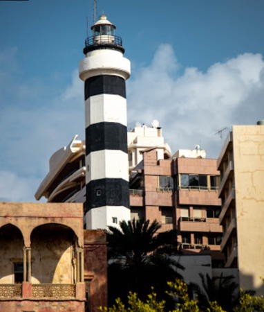
1957 (station established 1840s). Inactive since 2003. 27 m (89 ft) octagonal tower with lantern and a circular observation room. Tower painted with black and white horizontal bands. Jarrod Ryan's 2019 photo is at right, Wikimedia has Maya-Anaïs Yataghène's 2011 photo, Lois Bridenback has a 2008 photo, Sameh Obeid has a 2019 photo, and Google has a satellite view. Klaus Huelse has a postcard view of the original lighthouse. The second lighthouse, built in 1957, was out of service between 1982 and 1990 while Lebanon was torn by civil war and conflict with Israel. It was deactivated in 2003 when a high-rise building, the Manara Tower, was built in front of it. Rabih Ammash, the businessman who built the new building, contributed the funds to build the replacement lighthouse (next entry). The old lighthouse continued in use as a relay station for the state-owned Radio Liban. On 10 August 2006 Israeli aircraft shot off the radio station's antenna and damaged the top of the lighthouse. This damage was repaired. Around 2010 the lighthouse was renovated and the observation structure formerly under the lantern was removed. Members of the Chebli family have been keepers of all Beirut's lighthouses since the beginning. Located on a steep slope above the Corniche, Beirut's famous waterfront boulevard, about 400 m (1/4 mi) west of Ra's Bayrut, a cape projecting into the Mediterranean. Site open, tower status unknown.
* Beirut (Ra's Bayrut, Beyrouth) (3)
2003 (station established 1840s). Active (?); focal plane 52 m (171 ft); two white flashes every 10 s. Approx. 50 m (164 ft) round concrete tower with lantern and a circular observation room, centered on a square 2-story building. Originally the tower was unpainted gray concrete, but has been painted recently with red and white horizontal bands as seen in an October 2018 photo by Jamil Younes. Syed Rashid Abrar's photo is at the top of this page, Trabas has an excellent photo, a 2008 photo and another 2008 photo are available, and Google has a 2020 street view and a good satellite view. This new and very prominent lighthouse was inaugurated 25 September 2003. Libanvision has an article (in French, near the bottom of the page) about the construction of the lighthouse. On 15 July 2006 an Israeli air raid damaged the lantern and top of the lighthouse; Mathieu Baudier has a closeup photo taken on August 26 that shows this damage. The lighthouse has since been repaired. Note: light lists still describe the older lighthouse. Members of the Chebli family have been keepers of all Beirut's lighthouses since the beginning. Located on the point of Ra's (Cape) Bayrut, on the Beirut Corniche, about 400 m (1/4 mi) northwest of the former lighthouse. Site open, tower status unknown. Operator: Port of Beirut. . ARLHS LEB-002; Admiralty N5934; NGA 21116.

Old Beirut Light, Beirut, March 2019
Google Maps photo by Jarrod Ryan
* Beirut (Beyrouth) North Pier (2?)
Date unknown (station established 1895). Inactive at least since World War II. Approx. 13 m (43 ft) round concrete tower with gallery and four ribs, topped by a signal mast and rising from a 2-story building. Mario Goraieb has a photo (also seen at right), a 2022 view is available, and Google has a satellite view. Endangered: the building is abandoned and falling into ruin. The original lighthouse was described in 1920 as a stone tower. Located on the north breakwater of an inner basin at the west end of Beirut harbor, near the International Exhibition Center. Accessible by walking the pier. Site open, tower closed.

North Governorate Lighthouses
** Burj es-Sabaa (Tower of Lions)
Date unknown. Inactive but listed with a continuous red light by NGA. 21 m (69 ft) unpainted stone fortress. Nora Kalanjian has a photo, Mustapha Bodan has a 2020 photo, a more distant view is available, and Google has a satellite view, but no photos have been found that show a light on the building. The light has been dropped from the Admiralty list. The Tower of Lions was built in the late 1400s by the Mameluk Sultan Qa'it Bey as part of the defenses of Tripoli against attack by the Ottomans. Located at the edge of the Tripoli harbor district. Site open; the tower is preserved as a historical monument and is probably open, but we know nothing of the schedule. ex-Admiralty N5927.6; NGA 21060.
[Tripoli Jetée du Large]
Date unknown. Active; focal plane 10 m (33 ft); green flash every 4.5 s. Approx. 7 m (23 ft) post with gallery. No photo available but Google has a satellite view. There is a ssimilar light on the East Breakwater. Located on the main breakwater of Tripoli harbor. Site status unknown. Admiralty N5927; NGA 21052.
 

North Pier Light, Beirut, October 2014
Flickr Creative Commons photo by Mario Goraieb
Jazirat Ramkin (Ramkin Island, Île Ramkine) (2)
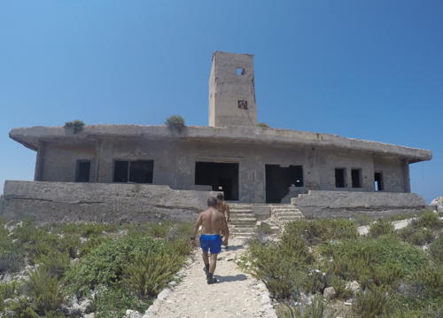
Date unknown (station established 1864). Inactive but listed with focal plane 22 m (72 ft); white flash every 3.3 s. Approx. 14 m square cylindrical masonry tower, rising from a 1-story masonry keeper's house. The light was displayed from a short post atop the tower. The lighthouse is unpainted yellow brick. Clearly endangered. The buildings of the station appear to be abandoned and in poor condition. Wayne Krieter's 2018 photo is at right, Rajaa Arnaout has a 2022 closeup, Haitham Massoud has a distant view, and Google has a satellite view. Ramkin Island is the westernmost of a chain of islets, summits of an underwater ridge, that extends northwestward from the city of Tripoli. Located about 5 km (3 mi) northwest of the city. Accessible only by boat. Site and tower closed. Operator: Port of Tripoli. ARLHS LEB-001; Admiralty N5926; NGA 21048.

Information available on lost lighthouses:

Notable faux lighthouses:


Jazirat Ramkin Light, Tripoli, July 2018
ex-Google Plus photo by Wayne Krieter

Adjoining pages: North: Syria | South: Israel

Return to the Lighthouse Directory index | Ratings key

Posted May 31, 2007. Checked and revised May 15, 2024. Lighthouses: 10. Site copyright 2024 Russ Rowlett and the University of North Carolina at Chapel Hill.