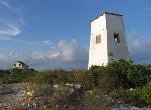
Lighthouses of the Turks and Caicos Islands

The Turks and Caicos Islands are located at the southeastern end of the Lucayan (Bahamas) Archipelago. For many years they were governed as part of the Bahamas, but in 1874 they were detached and placed under the Governor of Jamaica. When Jamaica became independent in 1962 the Turks and Caicos became a separate British Overseas Territory with its capital at Grand Turk (Cockburn Town). The population is roughly 45,000. There is only one major lighthouse but it is a very historic lighthouse, one of the oldest cast iron lights in the Western Hemisphere.

The islands are accessible by air and have a modern cruise ship terminal at Grand Turk developed by Carnival Cruise Lines.

Aids to navigation in the islands are the responsibility of the Fisheries and Maritime Affairs Department within the Ministry of Tourism.

ARLHS numbers are from the ARLHS World List of Lights. Admiralty numbers are from volume J of the Admiralty List of Lights & Fog Signals. U.S. NGA List numbers are from Publication 110.

General Sources
Online List of Lights - Turks and Caicos Islands
Photos by various photographers posted by Alexander Trabas.
Lighthouses in Turks and Caicos Islands
Photos by various photographers available from Wikimedia.
World of Lighthouses - Turks and Caicos Islands
Photos by various photographers available from Lightphotos.net.
Leuchttürme Mittelamerikas und der Karibik auf historischen Postkarten
Historic postcard views posted by Klaus Huelse.
GPSNavigationCharts
Navigation chart information for Turks and Caicos.
Navionics Charts
Navigation chart for Turks and Caicos.


Grand Turk Light, July 2014
Wikimedia Creative Commons photo by socaltraveler

Caicos Islands Lighthouses
* [Northwest Point (2)]
2020. Active; focal plane about 10 m (33 ft); three white flashes every 15 s. Approx. 6 m (20 ft) white post. A June 2020 photo is available but the small light is not seen in Google's satellite view. This light replaced an older post light shown in Dave Whitney's November 2019 photo and a Lightphotos.net photo from 2011 that shows the light serving as the platform for an osprey nest. NGA had reported the light "temporarily extinguished" in 2010. The light marks the south side of the Caicos Passage, the strait separating the Caicos Islands from the island of Mayaguana in the southeasternmost Bahamas. Located in the Northwest Point National Park at the northwestern tip of the island of Providenciales. Site open. Admiralty J4806.6; NGA 12384.
* South Caicos (Cockburn Harbour)
1890. Active; focal plane 15 m (49 ft); continuous white light. 4.5 m (15 ft) rectangular white concrete tower; the light, shown through a window, is visible only to the southeast. Brian Brake's photo is at right, Wikimedia has a photo from NGA Publication 147 and Google has an indistinct satellite view. The light guides vessels approaching a narrow opening in the Caicos reef. Located on the southeastern tip of South Caicos Island. Site open, tower closed. Admiralty J4808; NGA 12392.

Turks Islands Lighthouses
* Grand Turk
1852 (Alexander Gordon). Reactivated (1998); focal plane 33 m (108 ft); white flash every 7.5 s. 18 m (60 ft) cast iron tower, painted white, attached to kerosene storage house. A 4th order Fresnel lens (1943) from the lighthouse is on display at the Turks and Caicos National Museum. The keeper's house and kitchen also survive. A photo is at the top of this page, Greg Stokes has a photo, Reef News also has a good page with closeup photos, Trabas has a photo by Douglas Cameron, Wikimedia has several photos, Marinas.com has excellent aerial photos, Huelse has a historic postcard view, Google has a satellite view, and Lighthouse Digest has an article on earlier unsuccessful efforts to restore the lighthouse to kerosene power. The lighthouse was prefabricated in London by Chance Brothers; it is a very rare example of this early design in cast iron. After many years of neglect, the lighthouse was partially restored in 1998. In 2006 Carnival Corp., the cruise line holding company, granted funds to repaint and refurbish the lighthouse, keeper's cottage, and other light station buildings. This was part of much larger investment to develop Grand Turk as a regular stop for cruise ships. Grand Turk suffered considerable damage from Hurricane Ike in September 2008 but the lighthouse survived (though it needed repainting). The lighthouse was repainted in 2012. Located at the northern tip of Grand Turk Island; accessible by road. Cruise ships calling at the island offer tours that include the light station. Site open, tower closed. ARLHS TCI-001; Admiralty J4812; NGA 12408.
South Caicos Light
South Caicos Light, May 2007
Flickr Creative Commons photo by Brian Brake
[Big Sand Cay (1)]
Date unknown. Inactive. 15 m (49 ft) square skeletal tower, now rusted and lying on its side. The light was replaced by a short post light (focal plane 26 m (85 ft); white flash every 2 s). Jan Buskop reported that that light was not operating as of early 2008 and NGA listed it as "temporarily extinguished" in 2009. Trabas has a distant view by Capt. Theo Hinrichs, and Google has a distant satellite view. This light marks the southernmost point of the Turks and Caicos Islands, about 25 km (15 mi) south southwest of Grand Turk Island. Accessible only by boat. Site open, tower closed. Active light: Admiralty J4818; NGA 12432.

Adjoining pages: South: Haiti | West: Bahamas

Return to the Lighthouse Directory index | Ratings key

Posted September 16, 2005. Checked and revised November 15, 2023. Lighthouses: 2. Site copyright 2023 Russ Rowlett and the University of North Carolina at Chapel Hill.