Lighthouses of Southern Thailand: East Coast

Most of the Kingdom of Thailand faces south onto the Gulf of Thailand, an arm of the South China Sea. The country also includes much of the long and narrow Malay Peninsula, which separates the Gulf of Thailand from the Andaman Sea, an arm of the Indian Ocean.

Thailand is unique among southeast Asian nations in having maintained its independence throughout the colonial period. As a result the country's lighthouse history is also independent from all of the European traditions. Most of the country's historic lighthouses were built during or shortly after the reign of King Chulalongkorn (1868-1910), who was successful in modernizing the country while avoiding European penetration.

Thailand is divided into 76 provinces (changwat). This page includes lighthouses of the eight provinces on the Malay Peninsula's east coast; these provinces face east on the Gulf of Thailand.

In the Thai language the word for a lighthouse is prap̣hākhār (ประภาคาร), ko is an island, hin is a rock or reef, laem is a cape, ao is a bay, and maenam is a river.

Coastal lighthouses in Thailand are operated and maintained by the Hydrographic Department of the Royal Thai Navy.

ARLHS numbers are from the ARLHS World List of Lights. Admiralty numbers are from volume F of the Admiralty List of Lights & Fog Signals. U.S. NGA List numbers are from Publication 112.

General Sources
Leuchttürme in Thailand
Photos taken by Andreas Köhler.
Online List of Lights - Thailand
Photos by various photographers posted by Alexander Trabas. Many of the photos for Thailand are also by Köhler.
Lighthouses in Thailand
Photos by various photographers available from Wikimedia.
World of Lighthouses - Thailand
Photos by various photographers available from Lightphotos.net.
Navionics Charts
Navigation chart of the Thai coast.


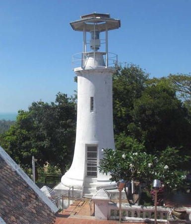
Songkhla Light, Songkhla, March 2017
photo copyright Andreas Köhler; used by permission
Prachuap Khiri Khan Province Lighthouse
Khao Takiab (Khao Takiap)
Date unknown. Active; focal plane 130 m (427 ft); two white flashes every 12 s. 6 m (20 ft) skeletal tower mounted on a round base, painted white. NGA calls the tower a tripod. Trabas has Köhler's photo and Google has an indistinct satellite view. Located atop a huge monolith at Nong Kae, south of the popular Hua Hin beach resorts. Site status unknown. Admiralty F2932.7; NGA 20776.
Mae Nam Pran Buri (Pranburi) Range Front
Date unknown. Active; focal plane 11 m (36 ft); yellow flash every 3 s. 8 m (26 ft) round bottle-shaped tower carrying a diamond-shaped daymark. Entire lighthouse is gray. Trabas has Köhler's photo and Bing has an indistinct satellite view. Located on the north side of the Pranburi River about 500 m (1/3 mi) above the entrance. Site status unknown. Admiralty F2932.49.
Mae Nam Pran Buri (Pranburi) Range Rear
Date unknown. Active; focal plane 18 m (59 ft); yellow light, 1.5 s on. 1.5 s off. 18 m (59 ft) round barbell-shaped tower carrying a diamond-shaped daymark. Entire lighthouse is gray. Trabas has Köhler's photo, a closeup 2018 street view is available, and Google has a 2019 street view and satellite view. Located in a side channel of the Pranburi River about 100 m (110 yd) southwest of the front light. Site status unknown. Admiralty F2932.491.
Ko Sattakut
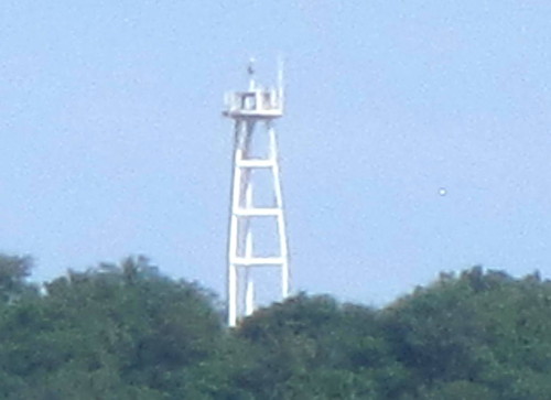
Date unknown. Active; focal plane 160 m (525 ft); three white flashes every 15 s. 11 m (36 ft) triangular white concrete skeletal tower. Köhler's photo is at right, Trabas has the same photo, and the light can be seen in Google's distant satellite view. Located atop a steep-sided, heavily forested island off the cape of Khao Sam Roi Yot. Accessible only by boat. Site status unknown. Admiralty F2932.4; NGA 20780.
Ko Raet
Date unknown. Active; focal plane 129 m (423 ft); white flash every 3 s. 4 m (13 ft) round white concrete tower with gallery. Trabas has Köhler's photo and Google has a distant satellite view. Located atop a small island off Prachuap Khiri Khan. Accessible only by boat. Site status unknown. Admiralty F2932; NGA 20784.
Ko Sattakut Light
Ko Sattakut Light, Prachuap Khiri Khan Province, November 2014
photo copyright Andreas Köhler; used by permission
Ban Khlong Wan Range Front
Date unknown. Active; focal plane about 8 m (26 ft); white light, characteristic unknown. Approx. 8 m (26 ft) round barbell-shaped metal tower painted white. Trabas has Köhler's photo and Google has a satellite view. and a distant street view. Located off the entrance to Ban Khlong. Accessible only by boat. Site open, tower closed. Admiralty F2931.8.
Ban Khlong Wan Range Rear
Date unknown. Active; focal plane about 16 m (52 ft); white light, characteristic unknown. Approx. 16 m (52 ft) round barbell-shaped metal tower painted white. Trabas has Köhler's photo (seen at right) and Google has a satellite view and a distant 2022 street view. Located about 250 m (800 ft) north of the front light. Accessible only by boat. Site open, tower closed. Admiralty F2931.81.
* Tharuea Prachuap Khiri Khan Range Front
Date unknown. Active; focal plane about 25 m (82 ft); red light, characteristic unknown. Approx. 25 m (82 ft) triangular skeletal tower, painted white and carrying a yellow diamond-shaped daymark. Köhler has a photo of the two range lights, Trabas has another photo by Köhler, and Google has a 2023 street view and a satellite view. Located on the waterfront at a harbor just north of the Hlaem Mae Ramphung lighthouse. Site open, tower closed. Admiralty F2931.
* Tharuea Prachuap Khiri Khan Range Rear
Date unknown. Active; focal plane about 30 m (98 ft); red light, characteristic unknown. Approx. 23 m (75 ft) triangular skeletal tower, painted white and carrying a yellow diamond-shaped daymark. Köhler has a photo of the two range lights, Trabas has Köhler's closeup of the rear light, and Google has a 2023 street view and a satellite view. Located about 150 m (500 ft) northwest of the front light. Site open, tower closed. Admiralty F2931.1.

Range Rear Light, Ban Khlong, March 2017
photo copyright Andreas Köhler; used by permission
Hlaem (Laem) Mae Ramphung
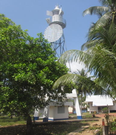
Date unknown. Active; focal plane 75 m (246 ft); white flash every 6 s. 30 m (98 ft) square skeletal tower, painted white. Köhler has a photo, Trabas has a larger version of the same photo, and Google has a satellite view. Located on a prominent cape at Mae Ramphung on the west side of the Gulf of Thailand. Site status unknown. ARLHS THA-011; Admiralty F2930; NGA 20788.

Chumphon Province
Lighthouses
Ko Rang
Date unknown. Active; focal plane 92 m (302 ft); white flash every 9 s. 7 m (23 ft) white skeletal tower. Trabas has Köhler's distant view, the light is high on the left in Saritdee Klangvichit's view from the sea and Google has a fuzzy satellite view. Located on a small island about 40 km (25 mi) northeast of Chumphon. Accessible only by boat. Site and tower closed (wildlife sanctuary). ARLHS THA-037; Admiralty F2928; NGA 20792.
Ko Mattaphon (Ko Mattra, Pak Nam Chumpon) (2)
Date unknown (station established 1908). Active; focal plane 47 m (154 ft); white light, 2 s on, 7 s off. 6 m (20 ft) square skeletal tower with lantern and gallery, painted white, mounted on a square concrete tower. A 2022 closeup photo is available, Trabas has Köhler's distant view, another view is available, and Google has a satellite view. The light tower stands beside the Malik Pagoda, a Buddhist monument. Located on an island at the south side of the entrance to the harbor of Chumphon, the provincial capital. Accessible only by boat. Site status unknown, tower closed. ARLHS THA-025; Admiralty F2924; NGA 20796.
Ko Rang Banthat
Date unknown. Active; focal plane 31 m (102 ft); three white flashes every 10 s. 6 m (20 ft) white concrete tower. A 2023 photo is available and Google has a distant satellite view. Located on a small island about 8 km (5 mi) offshore and 50 km (30 mi) south of Chumphon. Accessible only by boat. Site status unknown. ARLHS THA-038; Admiralty F2922; NGA 20800.
* [Mae Nam Tako]
Date unknown. Active; focal plane 9 m (30 ft); white flash every 3 s. 6 m (20 ft) white concrete post. Köhler has a photo, Trabas has the same photo, and Google has a street view and a satellite view. Located on the south side of the entrance to the port of Pak Nam Tako. Site open, tower closed. Admiralty F2923; NGA 20804.
* Lang Suan (3?)
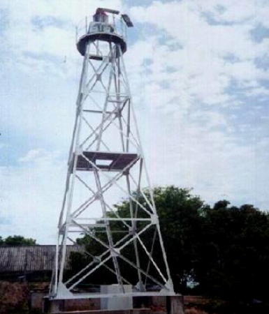
Date unknown (station established 1910). Active; focal plane 20 m (66 ft); white or red light, depending on direction, occulting twice every 5 s. 17 m (56 ft) square pyramidal skeletal tower, lower portion concrete and upper portion steel. Trabas has one of Köhler's photos (also seen at right), Köhler has a second photo, and Google has a street view and an indistinct satellite view. The previous lighthouse was a square skeletal tower with lantern and gallery. Located on the south side of the entrance to the Lang Suan River. Site open, tower closed. ARLHS THA-054; Admiralty F2920; NGA 20808.


Lang Suan Light, Chumphon Province, March 2017
photo copyright Andreas Köhler; used by permission

Surat Thani Province Lighthouses
Surat Thani is a city of about 135,000 residents on the Tapi (Bandon) River, which empties into the shallow Bandon Bay.
Ko Samui (Laem Sui)
Date unknown. Active; focal plane 35 m (115 ft); three white flashes every 12 s. 30 m (98 ft) square skeletal tower, painted white. Trabas has Köhler's photo, Phisut Phatthaisong has a distant street view, and Google has an indistinct satellite view. Located at the end of a long sand spit at the northern entrance to the bay of Surat Thani. Site status unknown. ARLHS THA-050; Admiralty F2918; NGA 20848.
Ban Don Entrance Beacon A
Date unknown. Active; focal plane 9 m (30 ft); two red flashes every 6 s. 8 m (26 ft) round barbell-shaped metal tower painted white. No photo available and the light is not seen in Google's satellite view. Beacons A and B are not listed as a range but they and the Ko Prap Light all stand on a line of approach to Surat Thani. Located in the entrance to Bandon Bay about 1.5 km (1 mi) north of Ko Prap.Site and tower closed. Admiralty F2916.3; NGA 20840.
Ban Don Entrance Beacon B
Date unknown. Active; focal plane 23 m (75 ft); white light occulting twice every 7 s. Approx. 18 m (59 ft) round barbell-shaped metal tower painted white. Peggy Anke has a 2023 view from the sea and Google has a satellite view. Located on the northwest shore of Ko Prap. Accessible only by boat. Site and tower closed. Admiralty F2916.5; NGA 20840.1.
Ko Prap (Ko Prab) (2?)
Date unknown (station established 1907). Active; focal plane 74 m (243 ft); white light, 1.5 s on, 4.5 s off. 14 m (46 ft) square pyramidal skeletal tower with gallery and a small lantern. A Navy photo is at right and Google has a satellite view. Located on a small island in the Bandon Bay. Accessible only by boat. Site and tower closed. ARLHS THA-034; Admiralty F2916; NGA 20836.
Ban Don Entrance Beacon C
Date unknown. Active; focal plane 8 m (26 ft); two green flashes every 6 s. 8 m (26 ft) round barbell-shaped metal tower painted white. Trabas has Köhler's photo and Google has a satellite view. Beacons C and D (next entry) appear to be range lights but they are not listed that way. Located on the north side of the entrance to the Ban Don River and the city of Surat Thani. Accessible only by boat. Site open, tower closed. Admiralty F2917; NGA 20844.
Ban Don Entrance Beacon D
Date unknown. Active; focal plane 23 m (75 ft); two white flashes every 6 s. 23 m (75 ft) round barbell-shaped metal tower painted white. Trabas has Köhler's photo and Google has a satellite view. Located on the north side of the entrance to the Ban Don River about 600 m (0.35 mi) southwest of Beacon C. Accessible only by boat. Site open, tower closed. Admiralty F2917.15 (ex-F2917.3); NGA 20844.1.
Ko Prap Light
Ko Prap Light, Surat Thani
Thai Navy photo
Ko Tao
Date unknown. Active; focal plane 69 m (226 ft); white flash every 5 s. 10 m (33 ft) round white concrete tower. Julian Pukropski has a closeup 2022 photo, Tom James has a closeup 2023 video of the lighthouse, Agustí Duran Parra has contributed a 2016 view from the sea, and Google has a distant satellite view. Ko Tao is an island about 70 km (45 mi) east of the Malay Peninsula. It was uninhabited when it was annexed by Thailand in 1899. For several decades it was the site of a political prison, but now it has resorts catering to ecotourists and scuba divers. The island is accessible by ferries from Chumphon and Surat Thani. Located at the northeastern tip of the island. Site and tower closed. ARLHS THA-042; Admiralty F2915.3; NGA 20812.
Ko Pha Ngan (Ko Phangan)
Date unknown. Active; focal plane 104 m (341 ft); two white flashes every 12 s. 20 m (66 ft) skeletal tower, painted white. Sergey Filin has a 2022 closeup photo, Loic Camus has a street view taken from the top of the lighthouse, and Google has an indistinct satellite view. Ko Pha Ngan is a popular resort island about 50 km (30 mi) southeast of Ko Tao and a similar distance north of the mainland. Located on a sharp promontory at the southeastern tip of the island. Site status unknown. ARLHS THA-032; Admiralty F2915.2; NGA 20816.
Laem Yai (Ko Samui)
Date unknown. Active; focal plane 58 m (190 ft); white flash every 5 s. 15 m (49 ft) square pyramidal skeletal tower, painted white. Trabas has Rainer Arndt's photo, Patrick Roddelkopf has a 2019 drone view, and Google has a satellite view. The largest Thai island, Ko Samui is halfway between Ko Phangan and the mainland. Located on a sharp promontory at the northwestern tip of the island. Site status unknown. ARLHS THA-053; Admiralty F2915; NGA 20820.
#Amphoe Ko Samui (Ban Ang Thong)
Date unknown. Apparently removed in 2017 but listed by NGA with focal plane 14 m (46 ft); two flashes every 7 s, white or red depending on direction. This was a 14 m (46 ft) round barbell-shaped metal tower, painted white. Trabas has a photo. The light appears onshore in the photo and a 2016 street view by Nikolay Skorokhodov, but it is missing from what should be a closeup street view taken in December 2017. Google has a satellite view of the former location. Site open, tower closed. ex-Admiralty F2914.8; NGA 20824.
Ko Palikan
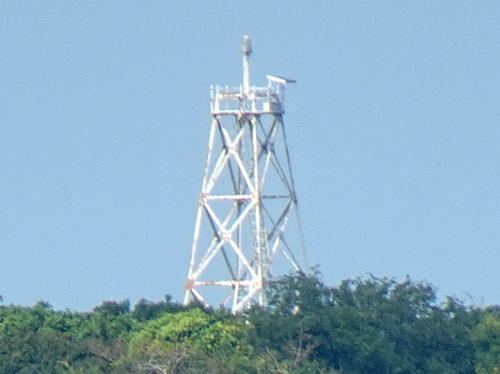
Date unknown. Active; focal plane 32 m (105 ft); white flash every 3 s. 15 m (49 ft) square pyramidal skeletal tower, painted white. Trabas has Köhler's photo (also seen at right), a fuzzy view from the sea is available, and Google has a satellite view. This light guides ships in a narrow passage between the mainland and the islands northwest of Surat Thani. Located atop the island of Ko Palikan. Site status unknown. ARLHS THA-030; Admiralty F2915.4; NGA 20828.
Ko Wang Nai
Date unknown. Active; focal plane 69 m (226 ft); three white flashes every 9 s. 9 m (30 ft) (?) square pyramidal skeletal tower, painted white. No photo available but Google has a satellite view. In the satellite view the tower appears taller than its listed height. Located on an island in the strait separating Ko Samui from the mainland. Accessible only by boat. Site status unknown. ARLHS THA-044; Admiralty F2914; NGA 20832.

Ko Palikan Light, Surat Thani, February 2023
photo copyright Andreas Köhler; used by permission
Nakhon Si Thammarat Province Lighthouses
* Sichon
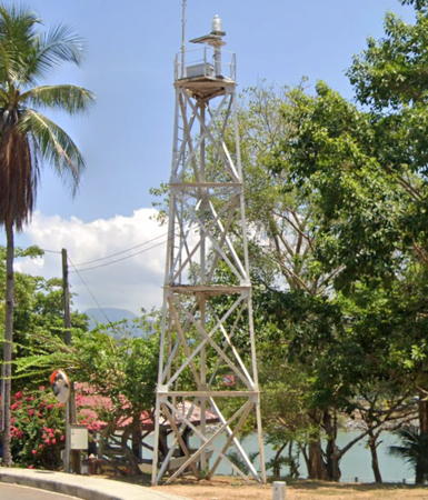
Date unknown. Active; focal plane 23 m (75 ft); flash every 3 s, white or red depending on direction. 11 m (36 ft) triangular skeletal tower painted with red and white horizontal bands. Köhler has a photo, Trabas has Köhler's photo as seen at right, and Google has a street view and a satellite view. Located at the entrance to a popular seaside park at the base of the south breakwater at Sichon. Site open, tower closed. Admiralty F2912; NGA 20852.
Nakhon (Mae Nam Pak Phun)
Date unknown. Active; focal plane 35 m (115 ft); white flash every 3 s. 30 m (98 ft) square pyramidal skeletal tower, painted white. No photo available but Google has a satellite view. Located about 16 km (10 mi) south of Tha Sala at the northern entrance to Nakhon Bay. Site status unknown. ARLHS THA-056; Admiralty F2910; NGA 20856.
Laem Talumphuk
Date unknown. Active; focal plane 30 m (98 ft); two white flashes every 10 s. 29 m (95 ft) square pyramidal skeletal tower, painted white. Köhler has a photo, Trabas also has Köhler's photo, a 2018 photo is available, and Google has a satellite view. Located on Laem Talumphuk, a hooked sand spit on the east side of Nakhon Bay. Site status unknown. ARLHS THA-052; Admiralty F2908; NGA 20860.
Ko Kra
Date unknown. Active; focal plane 178 m (584 ft); three white flashes every 20 s. 15 m (49 ft) white concrete tripod tower. No photo available but Bing has a satellite view. Ko Kra is a group of small islands about 65 km (40 mi) east of Laem Telumchuk. Located atop the largest of the islands. Accessible only by boat. Site status unknown. Admiralty F2909; NGA 20868.
 

Sichon Light, Sichon, March 2017
photo copyright Andreas Köhler; used by permission
 

Songkhla Province Lighthouses
Songkhla is a city of about 80,000 residents and an important port in southernmost Thailand. The city was formerly known by its Malay name Singora.
* Ranot
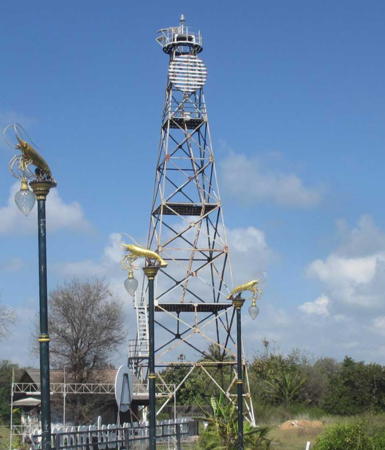
Date unknown. Active; focal plane 35 m (115 ft); white flash every 3 s. 31 m (102 ft) skeletal tower carrying a circular slatted daymark, painted white. One of Köhler's photos is at right, he has a similar photo, Trabas has the same photo, and Google has a 2023 street view and a satellite view. Located at Pak Trae in the Ranot District, at the north end of Songkhla Province. Site open, tower closed. Admiralty F2907; NGA 20872.
Songkhla Range Front
Date unknown. Active; focal plane 11 m (36 ft); green flash every 3 s. 11 m (36 ft) round barbell-shaped metal tower, painted white and mounted on a platform supported by piles. This is the entrance range for Songkhla. Trabas has Köhler's photo and Google has a 2022 street view from shore and a distant satellite view. Located a short distance off the Songkhla waterfront. Accessible only by boat. Site open, tower closed. Admiralty F2905; NGA 20884.
#Songkhla Range Rear (1)
Date unknown. Inactive since 2017 and since removed. This was an 11 m (36 ft) round barbell-shaped metal tower, painted white and standing on a large boulder. Trabas has Köhler's photo but the light is missing in Google's 2022 street view. Formerly located next to a major street one block from the waterfront. Site open.
Songkhla Range Rear (2)
2017. Active; focal plane 21 m (69 ft); green light, 2.5 s on, 2.5 s off. 11 m (36 ft) round white barbell-shaped tower. Google has a satellite view and a 2022 street view of the relocated light now located on the edge of the bay. Site open, tower closed. Admiralty F2905.1; NGA 20888.
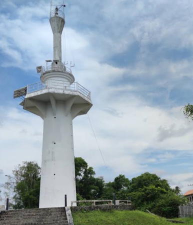
* Songkhla (Singora, Khao Tang Kuan)
1897. Active; focal plane 107 m (351 ft); two white flashes every 12 s. 14 m (46 ft) round white stucco-clad brick tower; lantern removed. Trabas has Köhler's excellent photo (also seen at the top of this page), Pakin Thanomkiat has a 2015 photo, a 2021 sunrise photo and a photo by Michael Holland are available, Michel Forand has a historic photo, and Google has a satellite view and a closeup street view. According to a local source (see entry #4), "The lighthouse was built by Phraya Wichian Khiri in 1897." Early light lists give 1909 as the date of establishment, but that was the date when the Thai royal government assumed direct control of Songkhla province and the lighthouse. The historic tower has been restored and painted recently. Located at the north end of a Buddhist temple complex on Tang Kuan hill, the highest point of a peninsula on the east side of the harbor entrance in Songkhla. Site open, tower closed. ARLHS THA-068; Admiralty F2904; NGA 20880.

Ranot Light, Songkhla Province, March 2017
photo copyright Andreas Köhler; used by permission
Pattani Province Lighthouses
The provincial capital of Pattani is a town of about 45,000 residents at the mouth of the Pattani River.
Mae Nam Pattani Range Front
Date unknown. Active; focal plane about 12 m (39 ft); light characteristic unknown. Approx. 12 m (39 ft) round barbell-shaped white tower carrying a diamond-shaped daymark. Google has a street view and a satellite view. Located in the entrance to Pattani harbor. Site appears open, tower closed. Admiralty F2902.
* Mae Nam Pattani Range Rear
Date unknown. Active; focal plane about 16 m (52 ft); light characteristic unknown. Approx. 13 m (43 ft) round barbell-shaped white tower carrying a diamond-shaped daymark. Rusamilae Pattani has a closeup 2022 street view and Google has a satellite view. Located on the south side of the entrance to Pattani harbor, about 200 m (1/8 mi) southeast of the front light. Site appears open, tower closed. Admiralty F2902.1.
#Laem Ta Chi
Date unknown (station established 1913). Removed in 2021 or 2022. 29 m (95 ft) square pyramidal steel skeletal tower with gallery. Google has a 2019 street view and a hazy satellite view but a 2022 street view confirms the removal. Located near the end of a spit sheltering the harbor of Pattani. Site status unknown, tower closed. ARLHS THA-051; Admiralty F2900; NGA 20896.
Ko Losin
Date unknown. Active; focal plane 12 m (39 ft); two white flashes every 5 s. 10 m (33 ft) square skeletal tower mounted on a concrete or masonry base. Tower painted white, base black with a white horizontal band. Michael Newman has a photo but the light is not shown in Google's satellite view. Located on an isolated rock about 90 km (56 mi) east northeast of Pattani. Accessible only by boat. Site open, tower closed. ARLHS THA-023; Admiralty F2895; NGA 20876.
Khlong Sai Buri
Date unknown. Active; focal plane 28 m (92 ft); white flash every 5 s. 26 m (85 ft) skeletal tower, painted white. Google has a 2023 street view and a fuzzy satellite view. Located at Sai Buri, a small port in southeastern Pattani province. Site status unknown, tower closed. ARLHS THA-014; Admiralty F2898; NGA 20912.

Narathiwat Province Lighthouse
* Tak Bai (Sungai Kolok Maenam Golok)
Date unknown. Active; focal plane 27 m (89 ft); white, red, or green light, depending on direction, 3 s on, 2 s off. 25 m (82 ft) round 2-stage white concrete tower with three galleries; the lower half of the tower is round and topped by a broad octagonal gallery; the upper section appears to be an hourglass-shaped fiberglass tower added to raise the height of the light. A photo by Tom Krittapas is at right, Naresuan Phetsang has a 2022 photo, and Google has a street view and a satellite view. Located beside a street in Tak Bai, just across the Golok River from Malaysia. ARLHS THA-061; Admiralty F2895.4; NGA 20878.

Tak Bai (Sungai Kolok) Light, Tak Bai, August 2016
ex-Google Plus photo by Krittapas tom

Information available on lost lighthouses:

Notable faux lighthouses:

Adjoining pages: Northeast: Central Thailand | Southeast: Northeast West Malayasia | West: Southern Thailand: West Coast

Return to the Lighthouse Directory index | Ratings key

Posted February 28, 2006. Checked and revised April 20, 2024. Lighthouses: 41. Site copyright 2024 Russ Rowlett and the University of North Carolina at Chapel Hill.