Lighthouses of Southern Thailand: West Coast

Most of the Kingdom of Thailand faces south onto the Gulf of Thailand, an arm of the South China Sea. The country also includes much of the long and narrow Malay Peninsula, which faces both east on the Gulf of Thailand and west on the Andaman Sea, an arm of the Indian Ocean.

Thailand is unique among southeast Asian nations in having maintained its independence throughout the colonial period. As a result the country's lighthouse history is also independent from all of the European traditions. Most of the country's historic lighthouses were built during or shortly after the reign of King Chulalongkorn (1868-1910), who was successful in modernizing the country while avoiding European penetration.

Thailand is divided into 76 provinces (changwat). This page includes the lighthouses of the six provinces on the Malay Peninsula's west coast. The Andaman Sea coast of Thailand has become a popular resort area in recent years. Some of the beach resorts were heavily damaged by the great tsunami of 26 December 2004, but the area has recovered well.

A number of attractive new lighthouses have been built recently in tourist areas. As far as I know these are faux lighthouses or unofficial lights.

In the Thai language the word for a lighthouse is prap̣hākhār (ประภาคาร), ko is an island, hin is a rock or reef, laem is a cape, ao is a bay, paknam is an estuary, and maenam is a river.

Coastal lighthouses in Thailand are operated and maintained by the Hydrographic Department of the Royal Thai Navy.

ARLHS numbers are from the ARLHS World List of Lights. Admiralty numbers are from volume F of the Admiralty List of Lights & Fog Signals. U.S. NGA List numbers are from Publication 112.

General Sources
Leuchttürme in Thailand
Photos taken by Andreas Köhler.
Online List of Lights - Thailand
Photos by various photographers posted by Alexander Trabas. Most of the photos for Thailand are also by Köhler.
Lighthouses in Thailand
Photos by various photographers available from Wikimedia.
World of Lighthouses - Thailand
Photos by various photographers available from Lightphotos.net.
Navionics Charts
Navigation chart of the Thai coast.


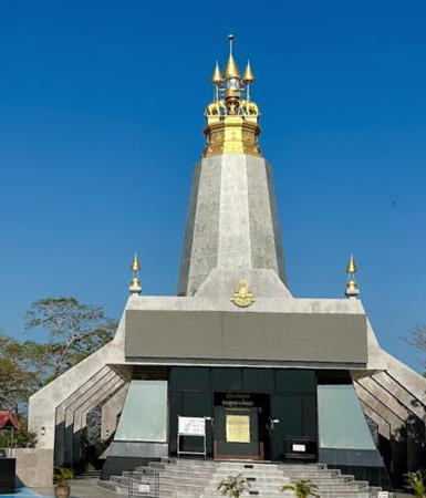
Laem Phra Chao Light, Phuket, March 2024
Google Maps photo by Jessica Möller
Satun Province Lighthouses
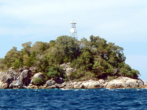
Ko Palai (Ko Dong)
Date unknown. Active; focal plane 49 m (160 ft); two white flashes every 12 s. 20 m (66 ft) square skeletal tower with gallery; the tower also carries a circular white daymark. A view from the sea is at right and the tower can be seen in Google's satellite view. Located on an islet in the Adang Islands, far out in the Andaman Sea south of Ko Rawi and about 100 km (60 mi) west of the mainland. Accessible only by boat. Site status unknown. ARLHS THA-029; Admiralty F1192.4; NGA 22152.
Ko Tangah
Date unknown. Active; focal plane 86 m (282 ft); white flash every 6 s. 20 m (66 ft) square skeletal tower painted white. No photo available but Google has a satellite view. Located atop the south end of an island in the center of the passage between Ko Adang and Ko Tarutao, about 60 km (38 mi) west of the mainland. Accessible only by boat. Site status unknown. ARLHS THA-041; Admiralty F1192.5; NGA 22156.
Ko Yao
1913. Active; focal plane 81 m (266 ft); three white flashes every 15 s. 7 m (23 ft) round brick tower painted white. No photo available but Google has a distant satellite view. Located on an island about 8 km (5 mi) south of Tammalang and a similar distance north of the Malaysian border. Accessible only by boat. Site status unknown. ARLHS THA-045; Admiralty F1194; NGA 22144.
Laem Puyu (Tanjung Dabus, Tanjung Pauh)
2008. Inactive since 2019. 15 m (49 ft) square skeletal tower painted white. A 2024 photo is available and Google has a satellite view. Located on the south side of the entrance to the bay of Puyu, about 15 km (9 mi) north of the Malaysian border. Site appears open, tower closed. ARLHS THA-062; ex-Admiralty F1193.8; NGA 22148.
 

Ko Palai Light , Satun, February 2010
Google Maps photo by WiJarn SingCum
 
Tanjung (Tonyong) Po
Date unknown. Active; focal plane 41 m (135 ft); two white flashes every 12 s. 16 m (52 ft) skeletal tower painted white. No photo available but Google has a satellite view. Located near the northern point of Tonyong Po, the tip of a peninsula jutting into the Andaman Sea. Site status unknown. ARLHS THA-063; Admiralty F1193; NGA 22160.
Ko Lela
Date unknown. Active; focal plane and light pattern unknown. Skeletal tower painted white. The tower is seen halfway through a short video clip by Andreas Holger, Holger also has a distant view posted, and Google has a satellite view. Located atop a small island off the northeastern corner of the much larger island of Ko Tarutao. Accessible only by boat. Site status unknown. ARLHS THA-022; Admiralty F1192.

Trang Province Lighthouses
The provincial capital of Trang is a city of about 60,000 residents located on the Trang River about 25 km (115 mi) from the sea.

Goh Beng (Ko Bulaobot)
1910. Active; focal plane 41 m (135 ft); two white flashes every 10 s. 12 m (39 ft) round brick tower, painted white. No photo available but Bing has a distant satellite view. Located on an island about 25 km (15 mi) off the coast in the Palian area. Accessible only by boat. Site status unknown. ARLHS THA-006; Admiralty F1188; NGA 22168.
* Yong Sata (Palian) (2)
Date unknown. Active; focal plane 48 m (157 ft); white flash every 5 s. 18 m (59 ft) round concrete tower with lantern and gallery, painted white. Google has a 2024 street view (a portion is seen at right), Anu Sanglapho has a 2021 photo, and a satellite view. NGA lists a skeletal tower. Located on a promontory about 10 km (6 mi) southwest of Palian. Site open, tower closed. Admiralty F1186; NGA 22172.
Ko Nok (Paknam Trang) Range Front
Date unknown. Active; focal plane about 10 m (33 ft); white light, pattern unknown. Approx. 10 m (33 ft) round barbell-shaped tower on a platform supported by piles. Trabas has Köhler's very distant view and Bing has a satellite view. This is the entrance range for the Trang estuary and the Trang and Palian Rivers. Located about 4 km (2.5 mi) west of Laem Po, the headland on the east side of the mouth of the estuary. Accessible only by boat. Site open, tower closed. Admiralty F1183.8.

Yong Sata Light, Palian, April 2024
Google Maps street view
Ko Nok (Paknam Trang) Range Rear
Date unknown. Active; focal plane about 15 m (49 ft); white light, pattern unknown. Approx. 15 m (49 ft) round barbell-shaped tower on a platform supported by piles. Trabas has Köhler's very distant view and Bing has a satellite view. Accessible only by boat. Located about 400 m (1/4 mi) north of the front light. Site open, tower closed. Admiralty F1183.9.
Ko Nok
Date unknown (station established 1910). Active; focal plane 9 m (30 ft); white flash every 3 s. 7 m (23 ft) square pyramidal skeletal tower mounted on a square 1-story equipment room. Google has a satellite view. This light is north of, but not quite in line with, the Ko Nok Range lights. Located on a small island on the west side of the estuary leading to the port of Kantang. Accessible only by boat. Site status unknown. ARLHS THA-027; Admiralty F1184; NGA 22176.
Khlong Palian Range Front
Date unknown. Active; focal plane 11 m (36 ft); yellow flash every 3 s. 11 m (36 ft) round barbell-shaped tower on a platform supported by piles. Trabas has Köhler's photo and Google has a satellite view. This is the second range for ships entering the Klang and Palian estuaries. Located on the shoal separating the mouths of the two rivers. Accessible only by boat. Site open, tower closed. Admiralty F1183.95.
Khlong Palian Range Rear
Date unknown. Active; focal plane 16 m (52 ft); yellow light, 1.5 s on, 1.5 s off. 16 m (52 ft) round barbell-shaped tower on a platform supported by piles. Trabas has Köhler's photo (also seen at right) and Google has a satellite view. Located about 500 m (1/3 mi) northeast of the front light. Accessible only by boat. Site open, tower closed. Admiralty F1183.98.

Khlong Palian Range Rear Light , Trang, February 2023
photo copyright Andreas Köhler; used by permission
Ban Na Klua Nua Range Front
Date unknown. Active; focal plane 19 m (62 ft); red flash every 3 s. No description available but probably this is an approx. 10 m (33 ft) round barbell-shaped white tower carrying a diamond-shaped daymark. No photo available and Google has only an indistinct satellite view. This is the first of hree ranges guiding ships to the waterfront of Katang. Located on a bluff on the west side of the Trang estuary a short distance south of the Ban Na Klua Nua School. Site status unknown. Admiralty F1184.5; NGA 22177.
Ban Na Klua Nua Range Rear
Date unknown. Active; focal plane 41 m (135 ft); white light, 2 s on, 2 s off. Approx. 13 m (43 ft) round post carrying a diamond-shaped daymark. Trabas has Köhler's photo and Google has a street view and a distant satellite view. Located about 500 m (1/3 mi) north of the front light. Site status unknown. Admiralty F1184.6; NGA 22177.1.
 

Krabi Province Lighthouses
Krabi is a fishing and tourist town at the mouth of the Krabi River. The town has a population of about 35,000.

* Ko Lanta (Ko Lanta Yai) (2)
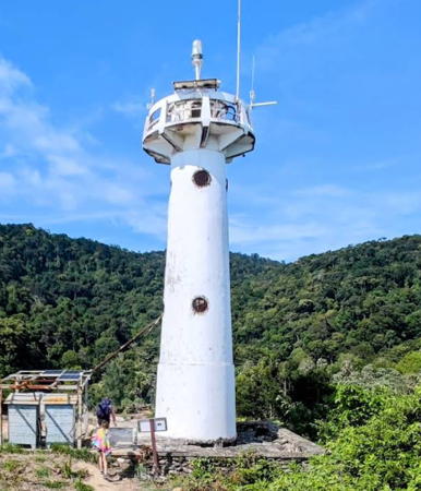
Date unknown. Active; focal plane approx. 35 m (105 ft); three white flashes every 15 s. Approx. 15 m (49 ft) round concrete tower with gallery. Lighthouse painted white (formerly white with one red horizontal band). A 2022 photo by Henry Anders is at right, a 2010 photo is available, another photo and a closeup showing the former red band are available, Trabas has a photo by Rainer Arndt, Lightphotos.net has a view from the sea, and Google has a street view and a satellite view. A photo is also available of the older light, a small cylindrical tower. Ko Lanta is a popular resort island about 100 km (60 mi) southeast of Phuket; much of the island is included in the Ko Lanta National Marine Park. Located at the southernmost point of the island; accessible by a hiking trail. Site open, tower closed. . ARLHS THA-021; Admiralty F1183; NGA 22180.
Khlong Si Bo Ya Entrance Range Rear
Date unknown. Active; focal plane 10 m (33 ft); white light, 1.5 s on, 1.5 s off. 10 m (33 ft) square pyramidal white skeletal tower on a platform supported by piles. No photo available but Bing has a satellite view. The front light is on a similar but shorter tower. Located in an estuary entrance at Khlong Khanan, about 15 km (9 mi) south of Krabi. Accessible only by boat. Site open, tower closed. Admiralty F1182.601; NGA 22191.5.

Ko Lanta Light, Krabi Province, December 2022
Google Maps photo by Henry Anders
Krabi Ko Nok
Date unknown. Active; focal plane 24 m (79 ft); white flash every 3 s. 21 m (69 ft) skeletal tower, painted white. Köhler has a photo, Trabas also has Köhler's photo, Facundo Orbea has a view from the sea, and Google has a satellite view. Located on an island in the entrance to Krabi harbor. Accessible only by boat. Site open, tower closed. Admiralty F1182; NGA 22192.
Krabi A (Entrance Range Front)
Date unknown. Active; focal plane about 12 m (39 ft); red flash every 3 s. 12 m (39 ft) round barbell-shaped white tower carrying a white diamond-shaped daymark and mounted on a small platform supported by piles. Lightphotos.net has a closeup photo, Trabas has Köhler's photo, and Google has a fuzzy satellite view. The rear light (Krabi B) is onshore on a post. Located about 800 m (1/2 mi) west of Krabi Ko Nok. Accessible only by boat. Site open, tower closed. Admiralty F1182.2; NGA 22193.
Krabi C (Inner Range Front)
Date unknown. Active; focal plane about 10 m (33 ft); white light, 1.5 s on, 1.5 s off. 10 m (33 ft) round barbell-shaped white tower carrying a white diamond-shaped daymark and mounted on a small platform supported by piles. Lightphotos.net has a closeup photo, Trabas has Köhler's photo, Mongkol Suwanphan has a photo, and Google has a street view and a satellite view. Located just off the south end of the Krabi waterfront. Accessible only by boat. Site open, tower closed. Admiralty F1182.4; NGA 22194.
* Krabi D (Inner Range Rear)
Date unknown. Active; focal plane about 17 m (56 ft); red flash every 3 s. 12 m (39 ft) round barbell-shaped white tower carrying a white diamond-shaped daymark. Trabas has Köhler's photo (also seen at right), Google has a street view, and Bing has a satellite view. Located on the west side of the Krabi Provincial Administration Building. Site open, tower closed. Admiralty F1182.5; NGA 22194.1.

Krabi Light D, Krabi, February 2023
photo copyright Andreas Köhler; used by permission

Phuket Province Lighthouses
The provincial capital of Phuket is a city of about 80,000 residents and a metropolitan population of about 250,000. It has a long history as an important trading center visited by Chinese and later Portuguese and other European merchants. Today it is the center for the resort areas of Thailand's west coast.
Khlong Tha Chin Range Front
Date unknown. Active; focal plane unknown; red flash every 5 s. Approx. 15 m (49 ft) round barbell-shaped white tower carrying a white diamond-shaped daymark. Köhler has a 2023 photo, Trabas has another of Köhler's photos, a 2022 photo is available, and Google has a satellite view. Located at the Ji Chang Fishery on the traditional waterfront of downtown Phuket. Site open, tower closed. Admiralty F1175.2; NGA 22190.2.
Khlong Tha Chin Range Rear
Date unknown. Active; focal plane unknown; white light, 2 s on, 2 s off. Approx. 20 m (66 ft) round barbell-shaped white tower carrying a white diamond-shaped daymark. Köhler has a 2023 photo, Trabas has a closeup of Köhler's photo, another photo is available, and Google has a satellite view. Located at the Ratanachai Shipyard in Phuket. Site open, tower closed. Admiralty F1175.4; NGA 22190.4.
Ko Taphao Noi (Phuket)
1899. Active; focal plane 55 m (180 ft); two white flashes every 20 s. 12 m (39 ft) round stucco-clad brick tower with gallery but no lantern, painted white. 1-story keeper's house adjacent to the lighthouse. Chadakorn Thapket's 2023 photo is at right, T. Sripinijchai has a 2016 photo, Wikimapia has a photo, Tim Laven has a closeup, Trabas has Jim Smith's view from the sea, and Google has a satellite view. Located on an island in the entrance to Phuket harbor. Accessible only by boat. Site and tower closed (naval reservation) except for occasional guided tours. ARLHS THA-043; Admiralty F1174; NGA 22188.
Phuket A (Range Front)
Date unknown. Active; focal plane about 9 m (30 ft); yellow flash every 3 s. 9 m (30 ft) round barbell-shaped white tower carrying a white diamond-shaped daymark and mounted on a small platform supported by piles. Trabas has Douglas Cameron's photo, the light is at the right in Wattana Phaibh's photo, Manupat Sriboonlue has a distant street view from shore, and Google has a satellite view. NGA lists the focal plane as 31 m (102 ft), a huge error. Located about 300 m (0.2 mi) off the Phuket Boat Quay. Accessible only by boat. Site open, tower closed. Admiralty F1174.6; NGA 22189.3.
* Phuket B (Range Rear)
Date unknown. Active; focal plane about 16 m (52 ft); yellow light, 2 s on, 2 s off. 16 m (52 ft) round barbell-shaped white tower carrying a white diamond-shaped daymark. Trabas has Douglas Cameron's photo, the light is at the left in Wattana Phaibh's photo, and Google has a street view and a satellite view. NGA lists the focal plane as 32 m (105 ft), a huge error. Located just off the Phuket Boat Quay. Site open, tower closed. Admiralty F1174.61; NGA 22189.31.

Ko Taphao Noi Light, Phuket, December 2023
Google Maps photo by Chadakorn Thapket
Laem Phan Wa (Laem Panwa) (?)
Date unknown. Active (?); focal plane 51 m (167 ft); three flashes every 15 s, white or red depending on direction. Approx. 8 m (26 ft) round barbell-shaped white metal or fiberglass tower. Andrey Bilevich has a closeup 2018 photo and Google has an indistinct satellite view of the listed location. This light is still listed by the Admiralty but when Köhler visited Phuket in February 2023 he was told the lighthouse no longer exists. Located atop the prominent Phan Wa headland in southern Phuket. Site and tower closed. Admiralty F1174.3; NGA 22189.
Laem Phan Wa (Laem Panwa) Southwest (2)
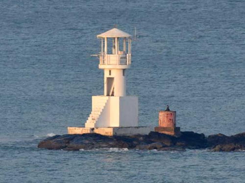
Date unknown. Active; focal plane about 12 m (39 ft); white flash every 5 s. Approx. 10 m (33 ft) round white tower with lantern mounted on a square base. Trabas has Jim Smith's photo (seen at right), Aleksey Nikitin has a photo and Google has a satellite view and a distant street view. Located on a reef a short distance southwest of the tip of the Phan Wa headland. Accessible only by boat but easy to see from shore. Site open, tower closed. Admiralty F1174.5; NGA 22189.1.
*** Laem Phra Chao (Kanchanaphisek, Promthep Cape)
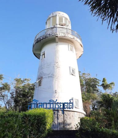
1996. Active; focal plane 94 m (308 ft); white flash every 9 s. 15 m (49 ft) octagonal white concrete tower with an ornately decorated gold top, rising from a 1-story building. Jessica Möller's 2024 photo is at the top of this page, Trabas has Köhler's closeup photo, a closeup of the tower is available, Anna Petts has a photo, Wikimedia has photos, and Google has a street view and a satellite view. The lighthouse was built to honor the 50th anniversary of the reign of King Bhumibol Adulyadej. Located at the southernmost point of Phuket Island, convenient to numerous resorts. Site open; visitors can climb to the observation platform on the tower. ARLHS THA-048; Admiralty F1169.5; NGA 22182.
Ko Kaeo Noi
Date unknown. Active; focal plane 52 m (171 ft); white flash every 6 s. 12 m (39 ft) white concrete tower. No photo available but Google has a distant satellite view. This is the landfall light for Phuket.The island is preserved as a natuoanl forest; it's possible that trails reach the lighthouse. Located about 4 km (2.5 mi) southwest of the Promthep Cape. Accessible only by boat. Site status unknown. ARLHS THA-019; Admiralty F1170; NGA 22184.

Laem Phan Wa Light, Phuket
photo copyright Jim Smith; used by permission

Phang Nga Province Lighthouses
Ban Thap Lamu (Laem Ao Kham, Ban Tablamu)
Date unknown. Active; focal plane 79 m (259 ft); white flash every 4 s. 30 m (98 ft) skeletal tower, painted with red and white horizontal bands. Roma Neus has a view from the sea, Trabas has Köhler's 2023 photo, and Bing has a satellite view. Located on a forested promontory marking an estuary entrance at Lam Kaen. Site status unknown. ARLHS THA-004; Admiralty F1167; NGA 22214.
Ban Thap Lamu Directional B
Date unknown. Active; focal plane 13 m (43 ft); continuous light, white, red or green depending on direction. 11 m (36 ft) round white fiberglass tower carrying a daymark colored red with a white vertical stripe. Trabas has Köhler's 2023 photo and Google has a satellite view. This is the entrance range for the estuary; there is an unlit front beacon. Located on the east side of the entrance. Site status unknown. Admiralty F1167.51.
Ban Thap Lamu No. 2
Date unknown. Active; focal plane 12 m (39 ft); red flash every 5 s. 12 m (39 ft) tapered round white fiberglass tower on a platform supported by piles. Trabas has Köhler's 2023 photo and Google has a distant satellite view. Located at the start of the Ban Thap Lamu entrance channel about 1.6 km (1 mi) northeast of Laem Ao Kham. Accessible onky by boat. Site open, tower closed. Admiralty F1167.1.
Ko Similan
Date unknown. Active; focal plane 169 m (554 ft); three white flashes every 20 s. 30 m (98 ft) skeletal tower, painted white. A distant view from the sea ia available and Google has a satellite view. Located on an island in the Andaman Sea about 80 km (50 mi) west of the Phang Nga coast. Accessible only by boat. Site status unknown. Site manager: Samilan Islands National Park. ARLHS THA-039; Admiralty F1168; NGA 22200.
Khao Lak
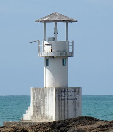
2009. Active; focal plane 12 m (39 ft); white flash every 5 s. 9 m (30 ft) round concrete tower with an open lantern mounted on a square concrete equipment shelter. Entire lighthouse is white. A photo is at right, Son Ma has a closeup photo, Trabas has Köhler's 2023 photo, Adisak Pinyakhong has a street view, and Google has a satellite view. Located on a rocky reef just off the Phang Nga coast at Khao Lak. Accessible only by boat but easy to see from the beach. Admiralty F1166.5.
Ko Ra
Date unknown. Active; focal plane 38 m (125 ft); three white flashes every 8 s. 9 m (30 ft) brick tower, painted white. No photo available but Google has a satellite view. Trabas has Köhler's very distant view of the top of the lighthouse. Located at the north end of Ko Ra, an island just off the north coast of Phang Nga. Accessible only by boat. Site status unknown. ARLHS THA-035; Admiralty F1166; NGA 22204.

Khao Lak Light, Khao Lak, March 2018
ex-Google Plus photo by Jonny T

Ranong Province Lighthouses
Ranong is a town of about 17,000 residents on the lower Pak Chan River, which forms the border between Thailand and Myanmar.

Ko Chi
Date unknown. Active; focal plane 115 m (377 ft); white flash every 10 s. 15 m (49 ft) skeletal tower, painted white. The light can be seen atop the island in P. Sirimotedara's 2024 view from the sea and Google has an indistinct satellite view. Ko Chi is the northernmost islet of the Mu Koh Surin archipelago, a national marine park about 40 km (25 mi) off Khura Buri. Accessible only by boat. Site status unknown. ARLHS THA-016; Admiralty F1164; NGA 22212.
Ko Luk Kham Tai
Date unknown. Active; focal plane 77 m (253 ft); white flash every 8 s. 15 m (49 ft) skeletal tower, painted white. No photo available but Google has a satellite view. Located on a small island about 12 km (7.5 mi) off the coast of the Suk Samran district. Accessible only by boat. Site status unknown. ARLHS THA-024; Admiralty F1165; NGA 22208.
Ko Phayam
Date unknown. Active; focal plane 64 m (210 ft); two white flashes every 12 s. 15 m (49 ft) white skeletal tower. No photo available but Google has an indistinct satellite view. Located at the western point of an island at the beginning of the approach to Ranong. Site status unknown. Admiralty F1163; NGA 22220.
Ko Khan (Ko Khom)
1893. Active; focal plane 55 m (180 ft); white flash every 3 s. 12 m (39 ft) round brick tower, painted white. No photo available but Google has a satellite view. Located on an island marking the border with Myanmar. Site status unknown. ARLHS THA-020; Admiralty F1162; NGA 22216.
Ko Son Thai
Date unknown. Active; focal plane 33 m (108 ft); two white flashes every 10 s. 15 m (49 ft) square skeletal tower, painted white. A photo is available and Bing has a satellite view. Located on a small island on the west side of the entrance to the Pak Chan estuary about 15 km (9 mi) southwest of Ranong. Accessible only by boat. Site status unknown. ARLHS THA-040; Admiralty F1161; NGA 22224.
Ko Sarani (Ko Phi) (2?)
Date unknown. Active; focal plane 20 m (66 ft); white flash every 3 s. 9 m (30 ft) square white skeletal tower. A customs and border control station is adjacent to the lighthouse. Trabas has Köhler's 2023 photo, another photo is available, and Bing has an indistinct satellite view. Another photo shows a smaller light. Located on a small island on the east side of the entrance to the Pak Chan estuary at Ranong. Accessible only by boat. Site open, tower closed. ARLHS THA-033; Admiralty F1160; NGA 22228.
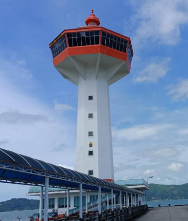
** Ranong (Customs Pier)
2007. Active; focal plane 49 m (161 ft); white flash every 4 s. 50 m (164 ft) octagonal concrete tower topped by a large observation structure that includes a restaurant. Tower painted white, observation structure orange. Del Piero's 2022 photo is at right, another photo is available, Trabas has Köhler's 2023 photo, another photo is available, and Google has a street view and a satellite view. When Köhler visited in February 2023 he found the restaurant closed for renovation. Located at the end of a pier projecting into the Pak Chan estuary at Ranong. Site open, tower probably open when the restaurant reopens. Admiralty F1159; NGA 22229.

Ranong Customs Pier Light, Ranong, October 2022
Google Maps photo by Mr. Del Piero

Information available on lost lighthouses:

Notable faux lighthouses:

Adjoining pages: North: Myanmar (Burma) | East: Southern Thailand: East Coast | South: West Malaysia Northwest Coast

Return to the Lighthouse Directory index | Ratings key

Posted February 28, 2006. Checked and revised June 3, 2024. Lighthouses: 43. Site copyright 2024 Russ Rowlett and the University of North Carolina at Chapel Hill.