Lighthouses of Southern Tunisia

Smallest of the North African nations, the Republic of Tunisia was a province of the Ottoman Empire until it was occupied by French troops in 1881 and declared a French protectorate. In World War II Allied forces converged on Tunisia from east and west and used it as the springboard for the invasions of Sicily and southern Italy. The country resumed its independence in 1956.

Northern Tunisia faces north on the western basin of the Mediterranean while the rest of the country faces east on the eastern basin. Cape Bon (Ra's at-Taib), east of the capital city of Tunis, is where the coast makes a right angle turn from one basin to the other.

Tunisia is divided into 24 governates (wilayat, sing. wilayah). This page describes lighthouses of the east coast governates, from Sousse to the Libyan border.

Arabic is the official language of Tunisia and nearly all residents speak a variety of Arabic called Tounsi. French is widely used in government and media and more than half of the population also speaks French. The Arabic word for a lighthouse is mnarh or manara (منارة). Ra's is a cape, jaza'ir or jazirat is an island, shi'b is a reef, shira' is a bay, and marfa is a harbor. In French phare is the word for a lighthouse, île is an island, cap is a cape, pointe is a promontory or point of land, roche is a rock, récife is a reef, baie is a bay, estuaire is an estuary or inlet, détroit is a strait, rivière is a river, and havre is a harbor.

Most of Tunisia's lighthouses were built by the French within the first 20 years of their colonial government. Today the lighthouses are maintained by Tunisian Lighthouse Services, an agency of the Tunisian Navy. It appears that most of them are maintained by resident civilian keepers with the original French lenses still in place.

ARLHS numbers are from the ARLHS World List of Lights. Admiralty numbers are from volume E of the Admiralty List of Lights & Fog Signals. U.S. NGA List numbers are from Publication 113.

General Sources
La signalisation maritime en Tunisie (1881-1920)
Article (in French) by Jean-Christophe Fichou on the development of Tunisian lighthouses. The article appeared in December 2010 in the Revue des mondes musulmans et de la Méditerranée.
Phares d'Afrique
Photos posted by Alain Guyomard and Robert Carceller as part of their Phares du Monde web site.
Online List of Lights - Tunisia
Photos by various photographers posted by Alexander Trabas.
World of Lighthouses - Tunisia
Photos available from Lightphotos.net.
Leuchttürme in Tunesien
Photos posted by Bernd Claußen.
Lighthouses in Tunisia
Photos by various photographers available from Wikimedia.
Afrikanische Leuchttürme auf historischen Postkarten
Historic postcard images posted by Klaus Huelse.
GPSNauticalCharts
Navigational chart information for Tunisia.
Navionics Charts
Navigational chart for Tunisia.

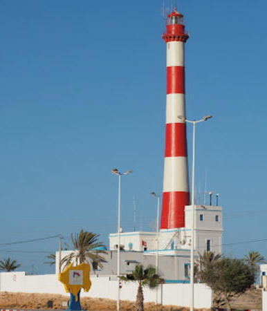
Ra's Tageurness Light
Ra's Taguerness Light, Djerba, March 2007
Wikimedia Creative Commons photo by Henning Leweke

Sousse Governate Lighthouses
Sousse is a city of about 300,000 residents facing east on the Mediterranean. Known as Hadrumetum in classical times, it has many historical monuments and is a popular tourist destination.

Sousse Jetée Abri
Date unknown. Active; focal plane 12 m (39 ft); white or red light, depending on direction, occulting once every 4 s. 8 m (26 ft) round masonry tower, upper half painted red, lower half white. Lightphotos.net has a photo, Magnus Ukkonen has a photo, Alvydas Sasnauskas has a closeup, and Google has a satellite view. Located at the end of the main breakwater mole of Sousse. Site and tower closed. Admiralty E6384; NGA 21952.
Sousse Epi Nord
Date unknown. Active; focal plane 10 m (33 ft); green light, 2 s on, 2 s off. 8 m (26 ft) round masonry tower painted green. Ouali Béchir has a sea view from a tour boat and Google has a satellite view. Located at the end of the north pier of Sousse. Site and tower closed. Admiralty E6385; NGA 21960.
Sousse Epi Sud
Date unknown. Active; focal plane 10 m (33 ft); red flash every 5 s. 8 m (26 ft) round masonry tower painted red. Ouali Béchir has a sea view, Ouali Béchir also has a sea view, and Google has a satellite view. Located at the end of the south pier of Sousse. Site and tower closed. Admiralty E6385.5; NGA 21964.
** Sousse (Susah)
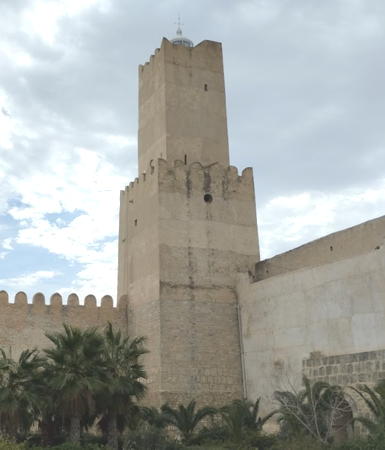
1890. Active; focal plane 70 m (230 ft); white flash every 4 s. 22 m (72 ft) 2-stage square tower with lantern rising from one corner of the Kasbah (citadel). Lantern painted white. Ad Mesken's photo is at right, Guyomard and Carceller have a photo by Étienne Mercier, Claußen has a photo, Wikimedia has a photo, another photo of the Kasbah shows the lighthouse, Huelse has a postcard view, and Google has a street view and a satellite view. This tower, known as Khalef al Fata, is said to have served as lighthouse as early as 859 CE. The building is now the national archeological museum. Located on the highest point of Sousse. Site open, tower reported (in 2004) to be open by arrangement with the keeper. Site manager: Musée Archéologique de Sousse. ARLHS TUN-019; Admiralty E6382; NGA 21956.

Sousse Kasbah and Light, Sousse, August 2012
Wikimedia Creative Commons photo
by Ad Meskens

Monastir Governate Lighthouses
Monastir is an agricultural center and seaside resort city of about 100,000 residents. Like Sousse it has a long history; it was called Ruspina in Roman times.

Île Kuriat (Jazirat Qurayyat)
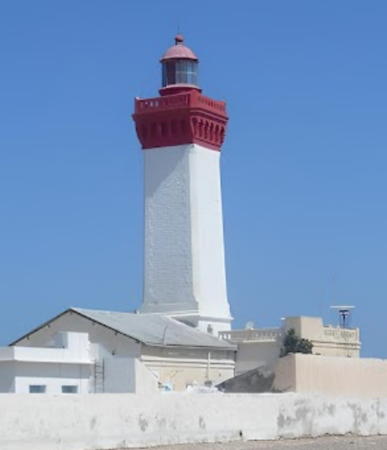
1894. Active; focal plane 30 m (98 ft); flash every 5 s, red to the north and white to the south. 26 m (85 ft) square masonry tower with lantern and gallery, rising from a 1-story keeper's house. Lighthouse painted white with the upper portion of the tower, lantern, and gallery painted red. Habib M'henni's closeup photo is at right, Mohsen Saafi has a view from the sea, and Google has a satellite view. Kuriat or Qurayyat is a small, uninhabited island about 20 km (13 mi) east of Monastir and 32 km (20 mi) north of Mahdia. Accessible only by boat. Site probably open, tower closed. ARLHS TUN-002; Admiralty E6380; NGA 21920.
Monastir Marina North Breakwater
Date unknown. Active; focal plane 11 m (36 ft); two white flashes every 10 s. 9 m (30 ft) post attached to a square 1-story equipment shelter. Trabas has a photo and Google has an indistinct satellite view. Located on the main breakwater of the marina at Monastir, a city of about 95,000 residents. Site status unknown. Admiralty E6378.
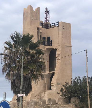
* Monastir (Burj el Kelb)
Date unknown (station established 1888). Active; focal plane 26 m (85 ft); two red flashes every 6 s. 6 m (20 ft) tower, described by NGA as a "minaret with black bands on east and south face." However, photos show what appears to be a lantern atop a fortified building. Nawress Nebli also has a photo, and Google has a fuzzed-out street view and a satellite view. Located near the fishing port in Monastir. Site open, tower closed. ARLHS TUN-031; Admiralty E6374; NGA 21932.
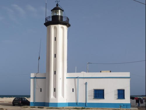
* Sayada (Saiadah)
Date unknown. Active; focal plane 8 m (26 ft); two long (2.5 s) white flashes every 15 s. 6 m (20 ft) round white masonry or concrete tower. Wikimedia has a good photo, Walid Kerkeni has a photo and a street view, and Google has a satellite view. Located at the end of the west (main) breakwater of Sayada, a fishing port about 15 km (9 mi) southeast of Monastir. Accessible by walking the pier. Site open, tower closed. Admiralty E6373.22; NGA 21924.
Phae de l'Île Kuriat
Île Kuriat Light, Monastir,, June 2010
Wikimedia Creative Commons photo by Habib M'henni

Mahdia Governate Lighthouses
Mahdia was the capital of Tunisia during the Middle Ages; today the ancient town is a fishing port and a popular tourist attraction. Its population is about 65,000.

* Mahdia (Cap Afrique)
1890. Active; focal plane 26 m (85 ft); red flash every 5 s. 15 m (49 ft) hexagonal cylindrical cast iron tourelle with lantern and gallery, mounted atop the keeper's house. Lantern and top of the tower painted red, the rest of the tower white. A photo by Gorik François appears at right, Trabas has a closeup photo, a 2008 photo is available, Claußen has photos, Wikimedia has many photos, and Google has a satellite view. Located on the point of Cap Afrique, a very sharp promontory in Mahdia. Site open, tower closed. . ARLHS TUN-013; Admiralty E6370; NGA 21904.
Salakta South Breakwater
Date unknown. Active; focal plane 13 m (43 ft); three green flashes, in a 2+1 pattern, every 10 s. 8 m (26 ft) concrete post light attached to a square 1-story equipment shelter. Entire lighthouse is green. Malek el Kamel has a view of both breakwater lighthouses and Google has a satellite view. Located on the south (main) breakwater of the fishing port of Salakta. Site and tower closed, but the light can be seen easily from the waterfront. Admiralty E6369.8.
Salakta West Breakwater
Date unknown. Active; focal plane 13 m (43 ft); red flash every 4 s. 8 m (26 ft) concrete post light attached to a square 1-story equipment shelter. Entire lighthouse is red. Malek el Kamel has a view of both breakwater lighthouses and Google has a satellite view. Located on the west breakwater of the fishing port of Salakta, about 12 km (8 mi) south of Mahdia. Site and tower closed, but the light can be seen easily from the waterfront. Admiralty E6369.81.
Mahdia Lighthouse
Mahdia Light, Mahdia, January 2006
Flickr Creative Commons photo by Gorik François (no longer online)
Ra's Kaboudia (Ra's Kapudia, Chebba) (1) (Borj Khadija, Tour Khadija)
Date unknown. Inactive. The light was mounted on a short skeletal mast atop a historic tower, the Borj Khadija, the sole surviving tower of a Byzantine era castle. Wikimedia has a photo and a closeup of the top of the tower, Houcine Nasri has a 2018 photo, Ahmed Moussa has a street view taken from the top of the tower, and Google has a satellite view. This lighthouse stands at the northern end of the Gulf of Gabès and marks the southern approach to the channel between the mainland and the island of Gharbi. In recent years the light was moved to a nearby mast (next entry), but the original light remains. Located on the point of Ra's Kaboudia at Chebba. Site status unknown. ARLHS TUN-011.
#[Ra's Kaboudia (Ra's Kapudia, Chebba) (2)]
Date unknown. Active; focal plane 28 m (92 ft); two flashes every 9 s, red for ships approaching from the south and white for those approaching from the north. The light was on an 18 m (59 ft) steel mast, painted with red and white horizontal bands and carrying a large topmark. The tower appears in Ahmed Moussa's 2015 street view taken from the top of the Borj Khadija, and it appears behind the Borj Khadija in a 2016 photo, but Google's satellite view shows the mast lying on the ground. It is believed that the light is moving to a new skeletal tower nearby, but no photos showing that tower are available. Located a short distance northeast of the Borj Khadija. Site status unknown. Admiralty E6368; NGA 21900.
Chebba Jetée Nord
Date unknown. Active; focal plane 8 m (26 ft); two green flashes every 9 s. 7 m (23 ft) octagonal green concrete tower. The tower is badly weathered in Amine Jerbi's 2019 closeup photo. Google has a distant satellite view. Located on the north breakwater at Chebba, a small port on the point of Ra's Kaboudia. Site status unknown. Admiralty E6369; NGA 21898.
Chebba Jetée Sud
Date unknown. Active; focal plane 8 m (26 ft); two red flashes every 6.5 s. 7 m (23 ft) octagonal white concrete tower. The tower is listed as red and is red in Fairouz Slama's 2005 photo, but it is white in Mohamed Bourmech's 2017 photo and other recent photos online. Google has a distant satellite view. Located on the south breakwater at Chebba, a small port on the point of Ra's Kaboudia. Site status unknown. Admiralty E6369.2; NGA 21899.

Sfax Governate Lighthouses
Sfax is Tunisia's second largest city with a population approaching 350,000. It is the country's largest fishing port and an industrial center.

Ra's Djlija
Date unknown. Active; focal plane 10 m (33 ft); two white flashes every 10 s. 9 m (30 ft) tower described by NGA as "Black pedestal, white top." No photo available but Google has a satellite view. The light guides vessels around the north end of the Kerkennah Islands, an archipelago in the northern entrance to the Gulf of Gabès. The islands have a population of about 15,000 and are a popular tourist destination. Located at the northern tip of Chergui, the largest of the islands. Site appears open, tower closed. Admiralty E6366.6; NGA 21852.
* Sfax Port (Leading Light)
Date unknown. Active; focal plane 18 m (59 ft); white light, occulting twice every 8 s, intensified along the range line. 17 m (56 ft) square tapered skeletal tower mounted on a 1-story rectangular equipment building. Tower painted black. Google has a satellite view. The light guides vessels in the entrance channel of Sfax harbor. Located on the Sfax waterfront. Site status unknown, but the tower must be easy to see from nearby. Admiralty E6362; NGA 21848.
Ra's Thyna (Ra's Thinah)
1895. Active; focal plane 55 m (180 ft); white flash every 5 s. 44 m (144 ft) round tapered conical masonry tower with lantern and gallery, attached to a 2-story keeper's house. Lighthouse painted with red and white horizontal bands; lantern is red. A photo is at right, Lightphotos.net has an excellent 2009 photo, Fayssal Marrekchi has a good photo, Huelse has posted a historic postcard view, and Google has a satellite view. The lighthouse was repainted in 2015. Sibling of the Ra's Taguerness Light on Djerba. Ruins of the Roman city of Thaenae are near the lighthouse. Located on a headland at Thyna about 15 km (9 mi) southwest of Sfax. Site status unknown. ARLHS TUN-009; Admiralty E6359; NGA 21836.
Skhira (Al Skhirra, La Skhirra) (2)
Date unknown (station established 1895). Active; focal plane 32 m (105 ft); green flash every 3 s. Approx. 30 m (98 ft) square skeletal tower painted dark green. No photo available but Bing has a satellite view. Al Skhirra is Tunisia's largest oil terminal, shipping oil from fields in both Tunisia and adjacent regions of Algeria. Located about 1.2 km (3/4 mi) northwest of the base of the main pier at La Skhirra. Site status unknown. Admiralty E6354; NGA 21828.
* La Skhirra (Al Skhirra, Skhira) (1)
1895. Inactive for many years. Approx. 7.5 m (25 ft) square cylindrical masonry tower with lantern and gallery rising from one corner of a 1-story building. The tower is near the left edge of Ridha Sellami's photo of the harbor, Lighthouse Digest has a historic photo, and Google has an indistinct satellite view. Endangered: the lighthouse is abandoned and deteriorating. Located at the traditional port of Skhirra, about 8 km (5 mi) southwest of the oil terminal. Site open, tower closed. ARLHS TUN-027; ex-Admiralty E6354.

Ra's Thyna Light, Sfax, September 2016
Wikimedia Creative Commons photo by Radiusmed

Gabès Governate Lighthouses
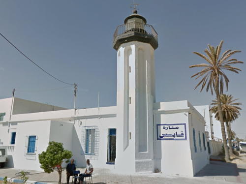
* Gabès
1893. Active; focal plane 13 m (42 ft); two white flashes every 6 s. 11 m (36 ft) octagonal cylindrical fluted tower with lantern and gallery, attached to a 1-story keeper's house. Tower painted white, lantern and gallery black. Lightphotos.net has an excellent photo, Alla Saed has a closeup photo, Huelse has posted a historic postcard view, and Google has a street view and a satellite view. Located at Gabès, an oasis town and seaport on the Gulf of Gabès. Site open, tower status unknown. ARLHS TUN-018; Admiralty E6348; NGA 21820.

Medenine Governate Lighthouses
The Medenine governate includes Djerba, a large island off the southern coast of Tunisia. The island has a population of about 120,000 and is a very popular tourist destination and beach resort. The island is accessible by frequent ferries from Ajim and by a long causeway (dating to Roman times) at Kantara.
Bordj Djillidj (Burj Dillij)
1895. Active; focal plane 16 m (52 ft); red flash every 4 s. 12 m (39 ft) octagonal tower with lantern and gallery, rising from a 2-story keeper's house within a small fortress. Tower painted white, lantern and gallery black. Ron Teeuw has a closeup photo, a 2010 photo of the light in action is available, Jalel Ben Ahmed has a 2018 closeup photo, Guyomard and Carceller have a distant view by Danièle Guyomard, and Google has a satellite view. Located at the northwest corner of the island of Djerba. Site status unknown. ARLHS TUN-022; Admiralty E6338; NGA 21780.
* Ra's Taguerness (Djerba)
1895. Active; focal plane 64 m (210 ft); white flash every 5 s. 49 m (161 ft) round tapered stone tower with lantern and gallery, attached to 2-story keeper's house. Lighthouse painted with red and white horizontal bands; lantern is red. Henning Leweke's photo is at the top of this page, Wikimedia has several good photos, Trabas has a photo, Mohamed Larachiche has a photo, Guyomard and Carceller have a portfolio of photos by Danièle Guyomard, and Google has a street view and a satellite view. This lighthouse marks the easternmost point of Djerba. Located about 20 km (13 mi) southeast of Houmt-Souk. Accessible by road. Site open, tower closed. . ARLHS TUN-010; Admiralty E6332; NGA 21764.
* Arghir (Aguir, Midoun, Madanin)
Date unknown. Active; focal plane 7 m (23 ft); white flash every 4.5 s. 7 m (23 ft) round cylindrical concrete tower with gallery. Lighthouse painted red with a single white horizontal band near the base. Aladar Wahlner has a photo, Guyomard and Carceller have a photo by Danièle Guyomard, Lenka Matíková has a view from the harbor, and Google has a satellite view. Located at the end of the jetty at Arghir, a small port on the southeastern coast of Djerba. Accessible by walking the pier. Site open, tower closed. Admiralty E6330.2; NGA 21760.
* El Kantara
Date unknown. Active; focal plane 5 m (16 ft); continuous white light. 5 m (16 ft) short mast atop a 1-story white building. Trabas has a photo and Google has a street view and a satellite view. Located on Djerba at the north end of the causeway. Site open, tower closed. Admiralty E6340; NGA 21758.
* Zarzis
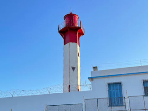
1894. Active; focal plane 15 m (49 ft); white light, occulting three times, in a 2+1 pattern, every 12 s. 14 m (46 ft) octagonal cylindrical fluted tower with lantern and gallery, attached to a 1-story keeper's house. Tower painted white, lantern and gallery black. A contributed photo is at right, another photo is available, and Google has a satellite view. Zarzis, called Gergis in ancient times, is a seaport in southernmost Tunisia. Located at the base of the breakwater of Zarzis. Site open, tower closed. ARLHS TUN-020; Admiralty E6328; NGA 21740.
Phare de Zarzis
Zarzis Light, Zarzis
anonymously contributed photo; used by permission

Information available on lost lighthouses:

Notable faux lighthouses:

Adjoining pages: East: Libya | West: Northern Tunisia

Return to the Lighthouse Directory index | Ratings key

Posted July 21, 2005. Checked and revised May 22, 2023. Lighthouses: 25. Site copyright 2023 Russ Rowlett and the University of North Carolina at Chapel Hill.