Lighthouses of Libya

The State of Libya (Darwat Libiya in Arabic) is located on the north coast of Africa between Tunisia in the west and Egypt in the east. The more populated regions of its coastline, Tripolitania in the west and Barqah (Cyrenaica) in the east, are separated by the broad bight of the Gulf of Sidra, the southernmost basin of the Mediterranean Sea.

After being ruled for more than 400 years as a province of the Ottoman (Turkish) Empire Libya was colonized by Italy in the early 20th century. After being captured by Allied troops in heavy fighting during World War II the country was under British military rule until it became independent in 1951. Under the rule of the dictator Muammar Gaddafi (1969-2011) Libya was estranged from the West for many years. Gaddafi was overthrown in heavy fighting during 2011. Since then the country has been torn by frequent unrest and civil war to the extent that no part of it has been safe for visitors. The two major combatants signed a ceasefire agreement in October 2020 and a government of national unity was formed in March 2021. However conditions remain very unstable and the U.S. State Department advises, "Do not travel to Libya due to crime, terrorism, civil unrest, kidnapping, and armed conflict."

Since 2007 Libya has divided into 22 districts (shabiyat).

For lighthouse fans Libya has been terra incognita for many years. Thanks to Khadija Teri for providing us with several photos taken before 2011 but little is known about many of the other lighthouses.

Arabic is the official language of Libya. The Arabic word for a lighthouse is mnarh or manara (منارة). Ra's is a cape, jaza'ir or jazirat is an island, shi'b is a reef, shira' is a bay, and marfa is a harbor.

In theory, at least, aids to navigation in Libya should to be maintained by the General Ports and Lights Authority.

ARLHS numbers are from the ARLHS World List of Lights. Admiralty numbers are from volume N of the Admiralty List of Lights & Fog Signals. U.S. NGA List numbers are from Publication 113.
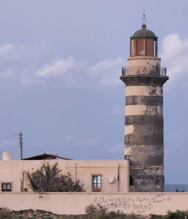
Tripoli Light
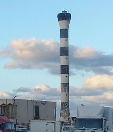
Tripoli Light, Tripoli, August 2006
photo copyright Khadija Teri; used by permission

General Sources

Online List of Lights - Libya
Photos by various photographers posted by Alexander Trabas.
World of Lighthouses - Libya
Photos available from Lightphotos.net.
Lighthouses in Libya
Photos by various photographers available from Wikimedia.
Afrikanische Leuchttürme auf historischen Postkarten
Postcards from the collection of Klaus Huelse.
Lighthouses of Africa
Postcards from the collection of Michel Forand.
GPSNauticalCharts
Navigational chart for Libya.
Navionics Charts
Navigational chart for Libya.


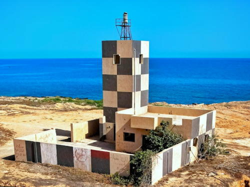
Farwah Light, Abu Kammash, April 2009
ex-Panoramio photo copyright Tarek al Hamruni; used by permission

Tripolitania (Tarabulus) Lighthouses

Nuqat al Khams District Lighthouses
Farwah (Farwa)
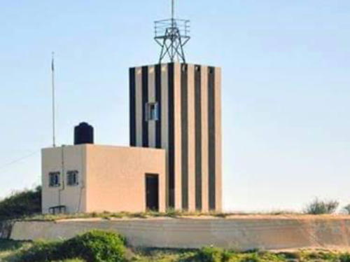
1920s. Inactive as of 2017 but listed with focal plane 17 m (56 ft); white light, 2 s on, 3 s off. Approx. 12 m (39 ft) square cylindrical masonry tower rising from a 1-story keeper's house; the light is shown from a short mast atop the tower. The tower is painted in a black and white checkerboard pattern; house painted white. Tarek al Hamruni's photo is above and Google has a satellite view. Muayed Bandaq had a street view (no longer available) showing someone in May 2017 working atop the lighthouse, which then had no lens. Located on a spit sheltering the small harbor of Abu Kammash, about 30 km (19 mi) east of the Tunisian border. Site status unknown. ARLHS LBY-003; Admiralty N6326; NGA 21728.
* Zuwara (Zuara) (2)
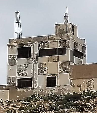
Date unknown (station established 1930s). Active; focal plane 15 m (49 ft); white flash every 5 s. 13 m (43 ft) short skeletal tower mounted on the roof of a 3-story waterfront building; the top of the building is painted with a black and white checkered daymark. No photo available but Google has a satellite view. Forand has a historic photo of the original lighthouse, which was probably destroyed during World War II. Located at the base of the breakwater of Zuwara harbor. Site open, tower closed. Admiralty N6322; NGA 21716.
Zuwara North Breakwater
Date unknown. Active; focal plane 11 m (36 ft); very quick flashing green light. 10 m (33 ft) square skeletal tower with gallery mounted on a square concrete base. Emad Omran has a 2013 photo and Google has a satellite view. Located at the end of the main breakwater of Zuwara. Site status unknown. Admiralty N6323; NGA 21720.
* Sabratah (Marsa Zuwaghah)
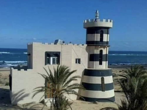
Date unknown. Active; focal plane 20 m (66 ft); white light, 1 s on, 1 s off. 6 m (20 ft) round cylindrical concrete tower with a conical base, attached to a small service building. Lighthouse painted with black and white horizontal bands. Yusuf Abu Qila has the 2013 photo seen at right and Google has a satellite view. Located near the shore about 6 km (3.5 mi) northwest of Sabratah. Site open, tower closed. Admiralty N6318; NGA 21712.

Sabratah Light, Sabratah, August 2013
Google Maps photo by Yusuf Abu Qila

Zawiya District Lighthouse
* Marsa Dila (Dilah)
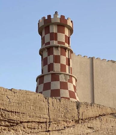
Date unknown. Apparently inactive, but listed by NGA with focal plane 24 m (79 ft); white flash every 4 s. Approx. 10 m (33 ft) round cylindrical concrete tower with a conical base, mounted on a large building (possibly an old fortress). Lighthouse painted in a red and white checkerboard pattern. Alla Saed's photo is below right, Qasoura al-Hasnawi has a view across the harbor, and Google has a satellite view. Located on the shore near Az-Zawiyah. Site open, tower closed. ex-Admiralty N6316; NGA 21708.

Tripoli District Lighthouses
Founded by Phoeniceans in the 7th century BCE, Tripoli is the capital and largest sity of Libya; it has a population of about 1.1 million.

Tarabulus (Tripoli) Main (4)
Date unknown (station established 1880). Active; focal plane 60 m (197 ft); two white flashes every 10 s. 26 m (89 ft) round cylindrical tower with a flared top, painted with horizontal black and white bands. Khadija Teri's photo appears at the top of the page and she has posted another photo. Trabas also has a photo, Lightphotos.net has a photo, a distant 2022 street view is available, and Google has a fine satellite view. The original lighthouse was destroyed by Italian naval shelling during the Turkish-Italian War of 1911. The second, a cast iron skeletal tower built in 1912, was replaced by a reinforced concrete tower similar in height and daymark to the present lighthouse. Designed by the Italian engineer Aldo Bruschi, the third lighthouse was built in 1924-26 and demolished in 1943 during World War II. Silvestro Bruschi, the designer's son, has contributed a photo of the third lighthouse, Michel Forand has a postcard view, and Huelse has a more distant postcard view. The present lighthouse must have been built sometime after the war, but the exact date is not known. Located on the waterfront in Tarabulus (Tripoli). Site status unknown; the immediate vicinity of the lighthouse may be restricted but the tower can be seen from nearby. ARLHS LBY-010; Admiralty N6294; NGA 21652.
Tarabulus (Tripoli) Spanish Mole (Pier #1)
Date unknown. Active; focal plane 10.5 m (34 ft); green light, 2 s on, 2 s off. 10 m (33 ft) round concrete tower, painted with black and white horizontal bands. A 2022 photo is available, Trabas has a distant view across the harbor, and Google has a satellite view. Located at the end of the easternmost mole on the north side of the harbor. Site and tower closed. ARLHS LBY-009; Admiralty N6304; NGA 21692.

Marsa Dila Light, Zawiya, January 2012
ex-Google Plus photo by Alla Saed
Tarabulus Karamanli Mole
Date unknown. Active; focal plane 10 m (33 ft); two red flashes every 6 s. 10 m (33 ft) round concrete tower, painted with red and white horizontal bands. Trabas has a distant view across the harbor and Google has a satellite view. Located at the end of a pier on the south side of the harbor. Site and tower closed. Admiralty N6305; NGA 21696.
Ra's Tajura
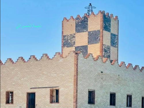
Date unknown. Active; focal plane 34 m (112 ft); white flash every 5 s. Approx. 17 m (56 ft) square cylindrical masonry tower attached to a 1-story keeper's house; the light is shown from a short skeletal tower on the roof. Lighthouse painted in a black and white checkerboard pattern. A 2022 photo by Muhamed Karmoos is at right, Miklos Kiss has a 2009 photo, Ziad Alhemdi has a 2016 photo, and Google has a satellite view. The lighthouse was restored in 2006-07. Tajura earned some notoriety as the site of Libya's former nuclear weapons development program. Located on a headland about 30 km (19 mi) east of Tripoli. Site status unknown. ARLHS LBY-007; Admiralty N6290; NGA 21644.
Ra's al Hallab (al-Qarābūll, Qara Bulli, Qara Boulle, Garaboulli)
Date unknown. Active; focal plane 35 m (115 ft); three white flashes every 15 s. 22 m (72 ft) round tower, painted white, topped by a short skeletal tower. Eng Alwaaer has a 2020 photo, Ahmad Swenia has a 2022 photo, Khairy M. Shaban has a sunset photo, Bashir Alzawawi posted several photos on Twitter, and Google has an indistinct satellite view. Endangered. The lighthouse is threatened by erosion of the cliff on which it stands; the cliff face has been armored with concrete to protect the station. Located on a headland projecting into the sea about halfway between Khoms and Tripoli. Site status unknown. ARLHS LBY-011; Admiralty N6288; NGA 21640.


Ra's Tajura Light, Tajura, September 2022
Google Maps photo by Muhamed Karmoos


Murqub District (Al Khoms Area) Lighthouses
* Ra's al-Misann
Date unknown. Active; focal plane unknown; white light, pattern unknown. Approx. 27 m (89 ft) round tower painted with black and white horizontal bands. No photo available but Google has a satellite view. Located southwest of a new harbor on the west side of Al Khoms. Site appears open, tower closed. Admiralty N6286.
* Al Khoms (Khums, Homs, Ra's al-Wazif)
Date unknown (station established 1881). Active (?); focal plane 26 m (85 ft); two white flashes every 10 s. 19 m (62 ft) round cylindrical tower with lantern and gallery, attached to a 1-story keeper's house. Tower painted with black and white horizontal bands. Khadija Teri's photo appears at right, Amr Yunes has a 2022 closeup, Forand has a historic (but distant) postcard view, and Google has a satellite view. The lighthouse is in poor condition and may be abandoned. Located on the waterfront drive in Al Khoms, a port about 80 km (50 mi) west of Misratah. Site open, tower closed. ARLHS LBY-001; Admiralty N6284; NGA 21636.
* [Leptis (Lepcis) Magna]
About 200 CE. Inactive since about 455 at least. Foundation ruins of a Roman lighthouse can be seen at Leptis (or Lepcis) Magna, just east of Al Khoms. Simon White has an excellent photo and another photo of the ruins (#4 on the page) is available. Google has an indistinct satellite view. This is the second tallest Roman lighthouse ruin, after the Dubris Pharos in Dover, England. In 196 the emperor Septimus Severus, who was born in Leptis Magna, launched a huge building program that made his home town into the second largest city of Roman Africa, after Alexandria. The city had a harbor sheltered by an east-pointing promontory and a breakwater. Built at the tip of the promontory, the lighthouse had three levels with high arches; a drawing shows what it may have looked like. Archaeologists believe it may have been as tall as 35 m (115 ft). The city was heavily damaged by an earthquake in 365 and conquered by the Vandals in 455. Today Leptis Magna, one of best preserved Roman cities anywhere, is (or was) one of Libya's best known tourist attractions. Located about 4 km (2.5 mi) southeast of Al Khoms. Site open.
Al Khoms Light
Al Khoms Light, Al Khoms
photo copyright Khadija Teri; used by permission

Misrata District Lighthouses
* Ra's Zurrugh (Ra's al Bara Barq, Ras Misratah)
Date unknown (station established 1881). Active (?); focal plane 24 m (79 ft); white flash every 5 s. 8 m (26 ft) square tower, painted with black and white vertical stripes and topped by a short skeletal tower. Anas Garman's photo is at right, Ashref Omran has a photo, Abdul Rahman Bayou has a 2020 photo, Abdalhakim Essofrani has a more distant view, and Google has a satellite view. This lighthouse marks the northwestern corner of the Gulf of Sirte. Located on the waterfront in Qasr Ahmed, about 10 km (6 mi) east of Misratah. Site open, tower closed. ARLHS LBY-013; Admiralty N6274; NGA 21628.
Misrata Steelworks Range Rear
Date unknown. Active (privately maintained); focal plane 19 m (62 ft); yellow light, 3 s on, 3 s off. Approx. 16 m (52 ft) skeletal tower. No photo available but Google has a satellite view. The front light is on a shorter tower on the main breakwater of the steel plant. Located near the base of the main breakwater at the Libyan Iron and Steel (Lisco) plant on the east side of Misrata. Site and tower closed. Admiralty N6278.1; NGA 21630.1.

Sirte District Lighthouses
The Sirte District includes the western 2/3 of the coast of the Gulf of Sidra (also called Sirte). The Gulf is a broad bight of the Mediterranean Sea, 439 km (273 mi) wide at the mouth and extending as much as 177 km (110 mi) southward. Its arid and sparsely populated coast separates the historic regions of Tripolitania and Cyrenaica.

* Sirte
Date unknown. Active (?); focal plane 35 m (115 ft); white flash every 5 s. Approx. 30 m (98 ft) white water tower. No photo available but Google has a satellite view. Sirte suffered heavy damage during the 2011 civil war and again in 2016 when Islamic State forces were defeated in the city. Located in downtown Sirte. Site open, tower closed. Admiralty N6268; NGA 21624.

Ra's Zurrugh Light, Qasr Ahmed, January 2014
ex-Google Plus photo by Anas Garman
Ra's Lanuf (Ra's al-Unuf)
Date unknown. Active; focal plane 50 m (164 ft); two quick white flashes every 5 s. 52 m (171 ft) white water tower. No photo available but Google has a satellite view. Ra's Lanuf is a major oil terminal and refinery, built near the southern end of the Gulf of Sidra. Located in the refinery complex. Site and tower closed. Admiralty N6266; NGA 21612.
Ra's Lanuf (Ra's al-Unuf ) Range Rear
Date unknown. Active; focal plane 17 m (56 ft); continuous white light. Approx. 15 m (49 ft) skeletal tower carrying a triangular daymark, point down, painted white with a black vertical stripe. No photo available but Bing has a distant satellite view. The front light is on a shorter skeletal tower. Located at the west end of the harbor of Ra's Lanuf. Site and tower closed. Admiralty N6266.51; NGA 21615.1.

Cyrenaica (Barqah) Lighthouses

Benghazi District Lighthouses
Located on the east shore of the Gulf of Sidra, Benghazi is the largest city of Cyrenaica with a population of more than 600,000.

* Benghazi (Banghazi) (2)
Date unknown (station established 1880). Active; focal plane 41 m (135 ft); white flash every 3 s. 22 m (72 ft) square cylindrical water tower topped by a 2-story "lantern" structure. The lighthouse has been repainted in a peach color with orange trim. David Stanley's photo is at right, Ravi Bilgi has a 2008 photo, a 2011 photo and a 2012 closeup are available, Issam Al-Muzaini has a 2021 photo of the lighthouse floodlit at night, Huelse has a historic postcard photo, Wikimedia has a 1931 photo, and Google has a street view and a satellite view. Michel Forand has a historic but distant postcard view that shows an earlier lighthouse at the far left. The lighthouse was refurbished and repainted in 2013 and a large clock was added to the seaward side. In June 2017 the lighthouse was damaged in a battle between government forces and militants; it was restored in a project in 2019-20. Located just off Ahmad Rafiq al Mahdawi Street, the seaside street, about 1.2 km (3/4 mi) northeast of the harbor area in Benghazi. Site open, tower closed. Admiralty N6251.8; NGA 21508.
Sidi Suwaykir
Date unknown. Active; focal plane 21 m (69 ft); four white flashes every 15 s. 15 m (49 ft) white square tower attached to a large building. A photo is available and Google has a satellite view. Located on the coastal highway on the southwest side of Daryanah, about 32 km (20 mi) northeast of Benghazi. Site status unknown. ARLHS LBY-008; Admiralty N6250; NGA 21500.
Benghazi Light
Benghazi Light, Benghazi, December 2010
Wikimedia Creative Commons photo by David Stanley

Marj District Lighthouse
Tolmeita (Tulmaythah, Addirsiyah)
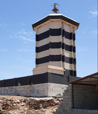
Date unknown (station established 1913). Active; focal plane 21 m (69 ft); three white flashes every 10 s. 16 m (52 ft) square cylindrical concrete tower topped by a short skeletal tower and mounted on a 1-story square concrete base. The tower and the base are painted with black and white horizontal bands. Salem Alharari's 2018 closeup is at right, Ibrahim Al Agouri has a good photo, and Google has a satellite view. The tower is similar to the Bardiyah lighthouse. Located on the northwestern "shoulder" of Cyrenaica about 105 km (65 mi) northeast of Banghazi. Site status unknown. ARLHS LBY-015; Admiralty N6248; NGA 21496.

Jabal al Akhdar District Lighthouses
Ra's Amir
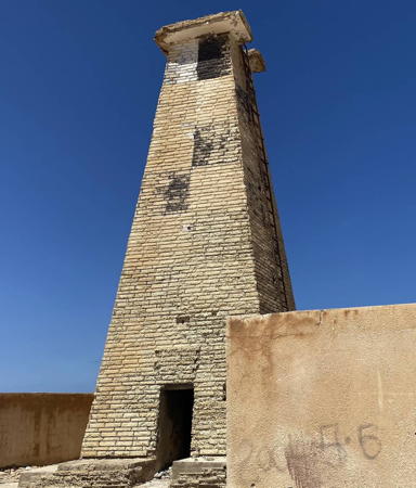
Date unknown. Active; focal plane 29 m (95 ft); two white flashes every 6 s. 11 m (36 ft) square pyramidal concrete tower, originally painted with black and white horizontal bands but nearly all the paint has faded away. Mohamed Ayad has a 2023 photo and Google has a satellite view. This lighthouse marks the northernmost point of Libya. Located on a headland about 25 km (15 mi) west of Susah. Site status unknown. ARLHS LBY-006; Admiralty N6246; NGA 21492.
Susah (Apollonia)
Date unknown (station established 1919). Inactive; listed with focal plane 25 m (82 ft); white flash every 6 s. 7 m (23 ft) pyramidal concrete tower, painted white. The light is seen at the left of David Stanley's photo, a second view is available, and Google has a satellite view. The light is clearly abandoned. Susah is the modern town on the site of the ancient Greek city of Apollonia, the principal port of Greek Cyrenaica. The city was destroyed by a tsunami in 365 and nothing remains of its Roman lighthouse. Located on the headland at the harbor entrance. Site status unknown. ARLHS LBY-014; Admiralty N6244; NGA 21488.

Darnah (Derna) District Lighthouses
Ra's al-Hilal
Date unknown. Active; focal plane 22 m (72 ft); three white flashes every 17.5 s. 12 m (39 ft) square pyramidal tower, painted in a black and white checkerboard pattern. Mohamed Ayad has a 2023 closeup photo and Google has a satellite view. Located on a prominent headland about 40 km (25 mi) east of Susah. Site status unknown. ARLHS LBY-012; Admiralty N6242; NGA 21484.

Tolmeita (Tulmaythah) Light, Tolmeita, May 2018
Google Maps photo by Salem Alharari
Darnah North Mole
Date unknown. Active; focal plane 14 m (46 ft); quick-flashing green light. Approx. 11 m (36 ft) square concrete tower with gallery. A 2021 photo is available and Google has a satellite view. Located at the end of the north mole, which is the main breakwater for Darnah harbor. Site status unknown. Admiralty N6239; NGA 21476.
Darnah South Mole
Date unknown. Active; focal plane 14 m (46 ft); quick-flashing red light. Approx. 11 m (36 ft) square concrete tower with gallery. The light is at the lower left in a distant aerial view of the harbor and Google has a satellite view. Located at the end of the south mole. Site status unknown. Admiralty N6238; NGA 21480.
Darnah (Derna)
Date unknown (station established 1880). Active; focal plane 60 m (197 ft); four white flashes every 20 s. 10 m (33 ft) tower with lantern and gallery, rising from a keeper's house. Lighthouse painted with black and white horizontal bands. The lighthouse is centered in a panoramic photo of the city (a small portion of this photo is at right) and Google has a satellite view. Huelse has a historic postcard view, and Forand has the same view. The original light was across town, on the west side of the city. Located on a bluff at the east end of Darnah, about 140 km (90 mi) northwest of Tobruk. Site status unknown. ARLHS LBY-002; Admiralty N6236; NGA 21472.
Ra's at-Tin (2?)
Date unknown. Active; focal plane 34 m (112 ft); white flash every 5 s. Approx. 15 m (49 ft) quare pyramidal tower, originally apainted in a black andd white checkerboard pattern but nearly all the paint has faded awayMohamed Ayad has a 2023 closeup photo and Google has a satellite view. NGA lists a 7 m (23 ft) skeletal tower. Located on a promontory about 50 km (30 mi) east of Darnah. Site open, tower closed. Admiralty N6234; NGA 21468.

Darnah Light, Darnah, July 2008
Flickr Creative Commons photo by Naji

Butnan (formerly Tobruk) District Lighthouses
Tobruk is a seaport with a population of about 130.000, located about 100 km (65 mi) from the Egyptian border. The city changed hands several times during heavy fighting in World War II, and it has been a center of resistance to the government in Tripoli during the recent struggles.

Punta Tobruq (Tobruk Point)
Date unknown. Active; focal plane 6 m (20 ft); green flash every 5 s. 5 m (17 ft) square concrete pyramid painted with black and white diagonal stripes. No photo available but Google has a satellite view. Located on the point on the north side of the entrance to Tobruk harbor. Site status unknown. Admiralty N6221; NGA 21440.
Tubruq (Tobruq, Tobruk) Main
Date unknown. Active; focal plane 53 m (174 ft); three white flashes every 15 s. 8 m (26 ft) 2-story masonry building with the light displayed from the roof on a short post. The entire building is painted in a black and white checkerboard pattern. A photo is at right, another photo is available, and Google has a satellite view. Located on a hilltop in the center of the peninsula that protects Tubruq's harbor. Site status unknown. ARLHS LBY-005; Admiralty N6220; NGA 21452.
Tobruq (Tobruk) Range Front (2?)
Date unknown. Active; focal plane 21 m (69 ft); quick-flashing white light. Approx. 15 m (49 ft) round concrete tower painted with black and white horizontal bands. No photo available but Google has a satellite view. This is the approach range for Tobruq. NGA describes a skeletal tower. Located on a promontory about 1.2 km (2 mi) east of Tobruq. Site status unknown. Admiralty N6224; NGA 21444.
Tobruq (Tobruk) Range Rear (2?)
Date unknown. Active; focal plane 26 m (85 ft); white light, 1 s on, 1 s off. Approx. 15 m (49 ft) round concrete tower painted with black and white horizontal bands. No photo available but Google has a satellite view. NGA describes a skeletal tower. Located 314 m (343 yd) southwest of the front light. Site status unknown. Admiralty N6224.1; NGA 21448.
Tubruq Light
Tubruq Light, Tubruq, October 2002
ex-Panoramio photo copyright Rahmoni; permission requested
Ra's Azzaz
Date unknown. Active; focal plane 16 m (52 ft); white flash every 3 s. 11 m (36 ft) skeletal tower, painted with black and white horizontal bands. No photo available but Google has a satellite view. Located on a prominent cape about 26 km (16 mi) north of Bardiyah. The site appears to be accessible only by boat. Site status unknown. Admiralty N6214; NGA 21436.
Bardiyah (Bardia, Burdi)
Date unknown. Active; focal plane 98 m (322 ft); white flash every 5 s. Approx. 12 m (39 ft) cylindrical tower, painted with narrow black and white horizontal bands. Google has a satellite view. Located atop a steep bluff on the south side of the entrance to Bardiyah, a village about 13 km (8 mi) northwest of the Egyptian border. Site status unknown. Admiralty N6210; NGA 21432.

Information available on lost lighthouses:

Notable faux lighthouses:

Adjoining pages: East: Mediterranean Egypt | West: Southern Tunisia

Return to the Lighthouse Directory index | Ratings key

Posted July 5, 2005. Checked and revised May 29, 2023. Lighthouses: 33. Site copyright 2023 Russ Rowlett and the University of North Carolina at Chapel Hill.