Lighthouses of Southwestern Türkiye

Prior to World War I (1914-18) the Ottoman (Turkish) Empire had for centuries controlled most of the Middle East and (for varying amounts of time) North Africa and Southeast Europe. Following the war the Empire was partitioned by the 1920 Treaty of Sèvres and after a period of turmoil and warfare the Republic of Türkiye (Türkiye Cumhuriyeti in Turkish) was established in 1923. The country was historically called Turkey but in 2022 the Turkish government informed the United Nations that it prefers the official spelling Türkiye to be used in English. The Directory uses the spelling Türkiye in its descriptions but retains Turkish as the adjective form and preserves the more familiar spelling Turkey on the index page.

Most of Türkiye (97%) is in Asia, including the broad peninsula of Anatolia (Asia Minor) with the Black Sea on the north, the Aegean Sea on the west and the Mediterranean Sea; on the south. The remaining 3% is the region of East Thrace at the southeastern corner of Europe.

For administrative purposes Türkiye is divided into 81 provinces (iller). This page includes Anatolian Türkiye's lighthouses on the Aegean coast in the provinces of Muğla and Aydın. This coast includes many popular resorts and is known as the Turquoise Coast or as the Turkish Riviera.

Since the 1920s the Turkish language has been written in a Latin script; a distinctive feature of the alphabet is that the dotted (İ and i) and dotless (I and ı) forms of the letter I are different letters. The Turkish phrase for a lighthouse is fener (plural fenerler) or deniz feneri ("sea lantern"). Ada or adası is an island, yarımada is a peninsula, kaya is a rock or reef, burnu is a cape, burun ("nose") is a headland, körfez is a gulf, koy is a bay or inlet, boğaz is a strait, nehir is a river, and liman is a harbor. In Turkish the Mediterranean Sea is called Akdeniz and the Aegean Sea is called Ege Denizi.

Lighthouses in Türkiye are operated by the Directorate General of Coastal Safety (Kıyı Emniyeti Genel Müdürlüğü, KEGM).

ARLHS numbers are from the ARLHS World List of Lights. Admiralty numbers are from volume N of the Admiralty List of Lights & Fog Signals. U.S. NGA List numbers are from Publication 113.

General Sources
Seyir Yardımcıları (Navigational Aids)
Information on major lighthouses posted by the Directorate General.
Online List of Lights - Turkey
Photos by various photographers posted by Alexander Trabas.
Deniz Fenerleri
Photos of 22 lighthouses by Haluk Özözlü.
Leuchtfeuer an der türkischen Mittelmeerküste
Photos of 17 Mediterranean coast lighthouses posted by Bernd Claußen.
Lighthouses in Turkey
Photos by various photographers available from Wikimedia.
World of Lighthouses - Turkey
Photos by various photographers available from Lightphotos.net.
Turkey South Lighthouses R Us
This site by C.W. Bash preserves a series of small photos formerly posted on the Directorate General's web site.
Europäische Leuchttürme auf historischen Postkarten
Historic postcard images posted by Klaus Huelse (Asiatic Türkiye is included on this page of European lighthouses).
GPSNauticalCharts
Navigational chart information for the southeastern Aegean Sea.
Navionics Charts
Navigation chart for the Turkish coast.

Kızılada Light, Fethiye, October 2018
Google Maps photo by Восток Подшипник

Muğla Province Lighthouses

Fethiye District Lighthouses
Fethiye is a resort city and seaport with a population of about 180,000.
** Kızılada (Kızıl Adalar)
1910. Active; focal plane 32 m (105 ft); white flash every 5 s. 13 m (43 ft) round masonry tower with lantern and gallery, attached to a 1-story masonry keeper's house. Entire lighthouse painted white, house painted white with a red tile roof. The lighthouse is floodlit at night. A 2018 photo is above, Trabas has a photo, a 2023 photo and a fine 2007 photo are available, KEGM has a page with a photo, Jonas Jonsson has a 2021 view from the sea, and Google has a satellite view. In 2008 the Kızılada Tourism Corporation leased the light station, restored the buildings, and opened them to tourists. A restaurant is open in part of the station. The Kızıl Adalar ("Red Islands") are a small group of islands in the Gulf of Fethiye. Located at the southern point of the largest island. Accessible only by boat. Site open, tower status unknown. ARLHS TUR-037; Admiralty N5841; NGA 20536.
Paçariz Burnu
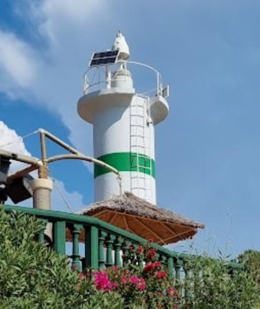
Date unknown. Active; focal plane 14 m (46 ft); green flash every 3 s. 8 m (26 ft) round cylindrical concrete tower, painted white with a green band at the top. Lili Balan's 2023 photo is at right, Trabas has a photo, KEGM's page has a photo, Samsonet Dodo has a photo, Uwe Jung has a photo, and Google has a satellite view. Located on a promontory on the west side of the entrance to the inner Gulf of Fethiye; this site is on the ground of a resort hotel. Site open to guests of the resort, tower closed. Site manager: Letoonia Club-Hotel. Admiralty N5843.5; NGA 20538.
Fethiye Adası (Megri Adası) South Point
Date unknown. Active; focal plane 17 m (56 ft); red flash every 3 s. 6 m (20 ft) mast atop a 1-story equipment building. Building painted white, mast white with a red top. Claußen has a photo (last photo on the page), Trabas has a view from the sea, and Google has a satellite view. Located on the south point of an island in the Gulf of Fethiye, opposite the Pacariz Burnu Light. Site status unknown. Admiralty N5842; NGA 20540.

Dalaman District Lighthouse
Peksimet Adası (2)
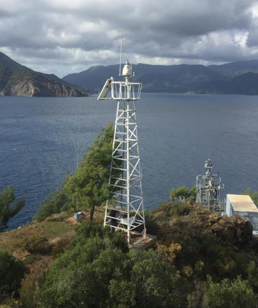
Date unknown (station established 1953). Active; focal plane 35 m (115 ft) (?); white flash every 10 s. Approx. 15 m (49 ft) square pyramidal skeletal tower, painted white. This tower replaced an 8 m (26 ft) round cylindrical concrete tower; both towers are shown by Claußen's photo. Bing has an indistinct satellite view. Located on a tiny island about 3 km (1.8 mi) offshore at the western entrance to the Gulf of Fethiye. Accessible only by boat. Site status unknown. ARLHS TUR-009; Admiralty N5839.5; NGA 20532.

Paçariz Burnu Light, Fethiye, October 2023
Google Maps photo by Lili Balan

Ortaca District Lighthouse
Baba Adası (2?)
Date unknown. Active; focal plane 58 m (190 ft); two white flashes every 5 s. 8 m (26 ft) square white skeletal tower. A 2019 view from the sea is available and Google has a satellite view. Trabas has a distant view of the previous lighthouse, a round hourglass-shaped white fiberglass tower. Ruined structures nearby must be a former light station; the photo also shows an older light but it was removed before the satellite view was made. Located on an island close offshore about 15 km (9 mi) southwest of Dalaman. Accessible only by boat. Site status unknown. Admiralty N5839.45; NGA 20520.

Köyceğiz District Lighthouse
Buğluca (2?)
Date unknown. Active; focal plane 67 m (220 ft); green flash every 6 s. 10 m (33 ft) square white skeletal tower. The KEGM photo is at right and Google has a distant satellite view. The satellite view shows a nearby structure, probably a ruined keeper's house. Located on a promontory on the east side of the entrance to Karaağaç Bay, a deep inlet east of Marmaris. Site status unknown. Admiralty N5838.6; NGA 20508.

Marmaris District South Coast Lighthouses
Marmaris is a historic seaport and now a very popular resort community. The permanent population is about 100,000.

Yılancık Adası (2?)
Date unknown. Active; focal plane 102 m (335 ft); flash every 5 s, white or red depending on direction. 7 m (23 ft) square white skeletal tower. A very distant view from the sea is available and Google has a satellite view. There is a square skeletal watch tower next to the lighthouse. Located on a high island off the entrance to Karaağaç Bay and about 18 km (11 mi) southeast of Marmaris. Accessible only by boat. Site and tower closed (military reservation). Admiralty N5838.4; NGA 20504.
Keçi Adası (Adassi Point, Keç Adası, Marmaris) (2)
Around 2006 (station established 1886). Active; focal plane 30 m (98 ft); red flash every 2 s. 14 m (46 ft) steel post mounted at the seaward end of the original (?) 1-story masonry keeper's house. House painted white with a red tile roof. Trabas has Thomas Philipp's photo, Claußen has a 2003 photo, a distant 2023 view from the sea is available, and Google has a satellite view. This lighthouse marks the west side of the narrow strait between Keçi Adası and the Adaköy peninsula. Located on an islet off the southeastern tip of Keçi Adası. Accessible only by boat. Site status unknown. Admiralty N5838; NGA 20500.

Buğluca Light, Köyceğiz
Directorate General of Coastal Safety photo
* Yalancı Boğaz Marina (Karayar)
Date unknown. Active; focal plane 12 m (39 ft); green flash every 5 s. Approx. 9 m (30 ft) round tower painted white with a narrow green horizontal band. Ahmet Alper Ozkan has a distant street view and Google has a satellite view. Yalancı Boğaz was a narrow strait at the eastern end of Keçi Adası, near the village of Karayar. The strait is now closed by a causeway and there is a large marina for yachts on the north side of the causeway. The lighthouse is located at the end of breakwater pier for the yacht harbor. Accessible by walking the pier. Site open, tower closed. Admiralty N5838.379; NGA 20503.3.
* Marmaris South Breakwater (2)
Date unknown. Active; focal plane about 12 m (39 ft); green flash every 4 s. Approx. 9 m (30 ft) round tower painted white with a narrow green horizontal band. Trabas has Thomas Philipp's photo and Google has a satellite view. Located on the south (main) breakwater of Marmaris. Accessible by walking the pier. Site open, tower closed. Admiralty N5838.3; NGA 20502.
* Marmaris West Breakwater
Date unknown. Active; focal plane 8 m (26 ft); red flash every 4 s. 5 m (17 ft) round stone tower with lantern and gallery, unpainted but with a red band around the base of the lantern. Trabas has Hartmut Knape's photo and Google has a street view and a satellite view. Located on the short west breakwater of Marmaris. Accessible by walking the pier. Site open, tower closed. Admiralty N5838.29; NGA 20501.3.
* Marmaris East Side
Date unknown. Active; focal plane 8 m (26 ft); four yellow flashes every 10 s. 5 m (17 ft) round stone tower with lantern and gallery, unpainted but with a yellow band around the base of the lantern. Trabas has Hartmut Knape's photo, Alexey Konyshev has a closeup 2023 photo, Nusret Kaymakçı has a street view, and Google has a satellite view. Located on the breakwater of a small boat harbor at the southwest corner of the harbor. Accessible by walking the pier. Site open, tower closed. Admiralty N5838.28; NGA 20501.2.
Kadırga Burnu (Cape Marmarice) (1)
1886. Inactive at least since 2007. 12 m (39 ft) steel post light mounted at the seaward end of a 1-story masonry keeper's house. House painted white with a red tile roof. KEGM's page has a photo , a 2017 view from the sea is available, and Google has a satellite view. Kadırga Burnu is the cape at the western entrance to the Gulf of Marmaris. Located at the tip of the cape, a very remote location; may be accessible only by boat. Site status unknown.
Kadırga Burnu (Cape Marmarice) (2)
Around 2007 (station established 1886). Active; focal plane 39 m (128 ft); three white flashes every 15 s. Approx. 15 m (49 ft) square skeletal tower, painted white. Located behind the historic lighthouse. Site status unknown. Admiralty N5836; NGA 20496.

Kadırga Burnu Light, Marmaris
Directorate General of Coastal Safety photo

Datça District Lighthouses
The Datça Peninsula is a 100 km (60 mi) long snake-like ridge that extends like a finger into the Aegean Sea north of the Greek island of Rhodes.

Datça İnce Burun (İnceburun)
Date unknown. Active; focal plane 14 m (46 ft); three white flashes every 15 s. 8 m (26 ft) round cykindrical white concrete tower with three narrow horizontal bands. Vural Atılgan has a photo, the light is at the right edge of a 2017 photo, KEGM has a page with a photo, and Google has a satellite view. İnce Burun ("sharp cape") is a common place name on the Turkish coast and there are several lighthouses with this name. Located at the end of a long gravel bar on the south side of the peninsula. Accessible only by boat. Site open, tower closed. ARLHS TUR-066; Admiralty N4732.5; NGA 20456.
* Deveboynu Burnu (Knidos Feneri)
1931. Active; focal plane 104 m (341 ft); two white flashes every 10 s. 9 m (30 ft) round cylindrical masonry tower with lantern and gallery, attached to a 1-story masonry keeper's house. Entire lighthouse painted white. Mehmet Ardıç's 2023 closeup photo is at right, Oytun Güventürk has a 2018 closeup, Mustafa Abanoz has a 2022 photo, Ercan Jay Aksoy has a photo from below the lighthouse, Wikimedia has a distant view, Trabas has Eckhard Meyer's very distant view, and a Google satellite view is available. Deveboynu Burnu (Camels' Neck Point) is the extreme southwestern corner of Anatolia, located at the tip of the long and narrow Datça peninsula. The lighthouse is at the tip of the peninsula. Accessible by a hike of about 1 km (0.6 mi) from the end of the road. Site open, tower closed. . ARLHS TUR-019; Admiralty N4732; NGA 20452.
Gökova İnce Burun (Cape Shuyun)
Date unknown. Active; focal plane 48 m (157 ft); two quick white flashes every 5 s. Approx. 15 m (49 ft) square white skeletal tower. Google has a distant satellite view. Located on a prominent cape on the north side of the Datça Peninsula. Site status unknown. Admiralty N4731.7; NGA 20240.

Marmaris District North Coast (Gökova Bay) Lighthouses
Gökova Kara (Zeytinli) Ada
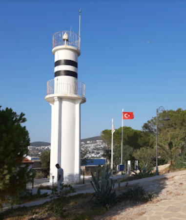
Date unknown. Active; focal plane 31 m (102 ft); white flash every 6 s. 7 m (23 ft) dumbbell-shaped fiberglass tower colored white with a narrow black horizontal band. Google has a satellite view. Located on Zeytinli Ada, an island about 25 km (15 mi) southwest of Akyaka. Accessible only by boat. Site status unknown. Admiralty N4731.5; NGA 20234.

Deveboynu Burnu Light, Datça, August 2023
Google Maps photo by Mehmet Ardıç
 
Orta Ada (2?)
Date unknown. Active; focal plane 15 m (49 ft); flash every 10 s, white or red depending on direction. 10 m (33 ft) dumbbell-shaped fiberglass tower colored white with a narrow black horizontal band. Bing has a satellite view. NGA lists a skeletal tower. Located on an island about 16 km (10 mi) southwest of Akyaka. Accessible only by boat. Site status unknown. Admiralty N4731.4; NGA 20232.

Milas District South Coast (Gökova Bay) Lightbeacon
* Ören
Date unknown. Active; focal plane 6 m (20 ft); white flash every 3 s. 6 m (20 ft) round white tower with one narrow black horizontal band. Mehmet Akif Asmaz has a photo, Ufuk Erdoğan has a street view, and Google has a satellite view. Located just off the beach at Ören, a town on the north coast of Gökova Bay. Site open, tower closed. Admiralty N4731; NGA 20230.

Bodrum District Lighthouses
Bodrum, the modern city on the site of the ancient Greek city of Helikarnassus, is now a very popular tourist resort and its historic harbor is usually crowded with yachts. The city's permanent population is about 200,000.

* Bodrum East Breakwater (2)
Date unknown. Active; focal plane 8 m (26 ft); green flash every 5 s. 7 m (23 ft) round cylindrical white concrete tower. Claußen has a photo, Trabas has a closeup by Günther Hess, Martijn Baudoin has a street view, and Google has a satellite view. NGA formerly listed a skeletal tower at this location. Located at the end of the east breakwater of Bodrum. Accessible by walking the pier. Site open, tower closed. . Admiralty N4730.4; NGA 20220.
* Bodrum (West Breakwater)
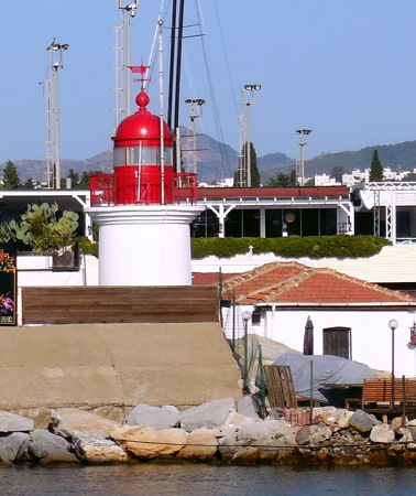
1880. Active; focal plane 8 m (26 ft); red flash every 5 s. 7 m (23 ft) round masonry tower with lantern and gallery, attached to a 1-story masonry keeper's house. Lighthouse painted white, lantern red, keeper's house white with a red tile roof. Tanya Dedyukhina's photo is at right, Claußen has a photo, Trabas has a closeup by Günther Hess, Paul Ciprian has a 2020 photo, Özözlü has a panoramic view (last thumbnail in sixth row), and Google has a satellite view. The lighthouse is located at the end of the short west breakwater. Site open, tower closed. ARLHS TUR-015; Admiralty N4730; NGA 20216.

Bodrum Light, Bodrum, September 2013
Wikimedia Creative Commons photo by Tanya Dedyukhina
* Hüseyin Burnu (Fener Burnu) (2?)
1931 (station established 1864). Active; focal plane 15 m (49 ft); two white flashes every 15 s. 9 m (30 ft) round stone tower with lantern and gallery, attached to a 1-story masonry keeper's house. Entire lighthouse painted white. A 2020 photo is at right, Trabas has Eckhard Meyer's photo, Bora Vinchenso Augurio Bodurhas a 2017 closeup photo, Jonas Vandevelde has a street view, and Google has a satellite view. The Coastal Safety Directorate lists 1964 as the date of this lighthouse but its design resembles 1930s era light stations such as Deveboynu (see above). This lighthouse marks the Kos Channel, a 5 km (3 mi) wide passage between the Turkish mainland and the Greek island of Kos. An adjoining keeper's house is renovated as a restaurant. Located on the cape on the west side of Gokdiken and about 4 km (2.5 mi) south of Turgutreis. Accessible by road. Site open, tower closed. . ARLHS TUR-026; Admiralty N4712; NGA 20208.
* Turgutreis East Breakwater
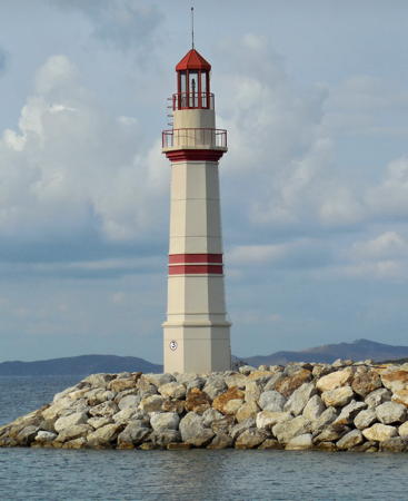
Date unknown (recent). Active (privately maintained); focal plane 19 m (59 ft); green flash every 5 s. Approx. 16 m (52 ft) hexagonal tower with lantern and gallery. Lighthouse painted gray with a narrow green horizontal band; lantern painted green. Muhittin Kiliç has a photo of both lighthouses, Google has a street view and a satellite view. These lighthouses were built as part of a marina development project at Turgutreis, a tourist town named for the 15th century Ottoman admiral Turgut Reis. Located at the end of the east breakwater at Turgutreis, probably accessible by walking the breakwater. Site open, tower closed. Charted by Navionics but not listed by the Admiralty.

Hüseyin Burnu Light, Turgutreis, April 2020
Instagram photo by denizfeneri_lighthouse
* Turgutreis West Breakwater
Date unknown (recent). Active (privately maintained); focal plane 19 m (59 ft); red flash every 5 s. Approx. 16 m (52 ft) hexagonal tower with lantern and gallery. Lighthouse painted gray with a narrow red horizontal band; lantern painted red. Tanya Dedyukhina's photo is at right, Joe Lopez has a photo, James Sherrett also has a photo, Muhittin Kiliç has a photo of both lighthouses, and Google has a street view and a satellite view. Located at the end of the main (west) breakwater at Turgutreis, probably accessible by walking the breakwater. Site open, tower closed. Charted by Navionics but not listed by the Admiralty.
Bağarası Kara Ada (Fener Adası)
Date unknown. Active; focal plane 17 m (56 ft); white flash every 5 s. 6 m (20 ft) white concrete tower. Raif Dayı has a 2018 view from the sea, a distant view from the sea is available, and Google has a distant satellite view. Located on an island off the northernmost tip of the Bodrum Peninsula, about 3 km (2 mi) northwest of Bağarası. Accessible only by boat. Site open, tower closed. Admiralty N4665.2; NGA 20172.

Milas District West Coast Lighthouses
* Güllük (Çamlık Burnu)
Date unknown. Active; focal plane 11 m (36 ft); two white flashes every 5 s. 9 m (30 ft) round barbell-shaped metal tower. Lighthouse painted white with two narrow black bands. A neighboring house may be a former keeper's house. Trabas has Eckhard Meyer's closeup photo, Nesibe Aktaş has a 2017 photo, Dünyalı Bisiklet Gezgin has a photo, and Google has a satellite view. Located on a promontory at Güllük, a popular resort village. Site open, tower closed. Admiralty N4665.4; NGA 20164.
İncegöl Burnu
Date unknown. Active; focal plane 13 m (43 ft); white flash every 3 s. 9 m (29 ft) barbell-shaped metal tower mounted on a round 1-story concrete base. Google has a distant satellite view. Located at the tip of a peninsula about 15 km (9 mi) west of Güllük. Accessible only by boat. Site open, tower closed. Admiralty N4665.6; NGA 20168.

West Breakwater Light, Turgutreis, September 2013
Wikimedia Creative Commons photo by Tanya Dedyukhina

Aydın Province Lighthouses

Didim District Lighthouses
Altın (Akbuk-Panayir) Adası
Date unknown. Active; focal plane 35 m (115 ft); three white flashes every 15 s. 8 m (26 ft) round white concrete tower. Google has a distant satellite view. Located on an island about 3 km (2 mi) southeast of Didim. Accessible only by boat. Site status unknown. Admiralty N4665.7; NGA 20162.
Tekağaç Burnu
1954. Active; focal plane 15 m (49 ft); white flash every 15 s. 12 m (39 ft) round barbell-shaped tower. Lighthouse painted white with a narrow black horizontal band. Görkem Terzioğlu has a 2019 closeup photo, Aydın Kudeb also has a closeup, and Google has a distant satellite view. Located on a promontory on the Gulf of Mandalya about 6 km (3.5 mi) southwest of Yenihisar. Site status unknown. ARLHS TUR-051; Admiralty N4665.8; NGA 20160.

Kuşadası District Lighthouses
Bayrak Adası (1)
Date unknown (station established 1864). Inactive. 7 m (23 ft) round concrete tower with four ribs and gallery, attached to a 1-story keeper's house. Lantern removed. A closeup photo is available, Fazlı Memiş has a distant view from the sea and Bing has a satellite view. The light was still active in Esref Ucar's 2007 photo. NGA misspells the name as "Baytak Adasi." Located on Bayrak Adası (Flag Island), a small island in the narrow channel between the Turkish mainland and the Greek island of Samos. Accessible only by boat. Site status unknown.
[Bayrak Adası (2)]
Date unknown. Active; focal plane 23 m (75 ft); white flash every 5 s. 7 m (23 ft) square skeletal tower, painted white. Fazlı Memiş has a distant view from the sea. Located beside the historic lighthouse. Accessible only by boat. Site status unknown. Admiralty N4665; NGA 20016.
* Kuşadası (Güvercin Adası, Scala Nova) (2)
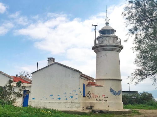
Date unknown (station established 1864). Active; focal plane 20 m (66 ft); two white flashes every 10 s. 8 m (26 ft) round cylindrical concrete tower with gallery and four ribs. Entire lighthouse is white. 1-story masonry keeper's house, painted white with a red tile roof. Vitaly Pavlov's photo is at right, Trabas has Hartmut Knape's photo, Wikimedia has a closeup photo, another closeup is available, and Google has a satellite view. Kuşadası ("Bird Island") is a resort town and cruise ship port on the Turkish mainland northwest of the Greek island of Samos. The ruins of ancient Ephesus are nearby. The town got its name from the island on which the lighthouse is located, since the island is shaped like a bird's head. Located at the northwest point of the island, which is connected to the mainland by a causeway. Site apparently open, tower closed. ARLHS TUR-041; Admiralty N4664; NGA 20004.
Kuşadası Yacht Harbor East Breakwater
Date unknown. Active (privately maintained?); focal plane 8 m (26 ft); green flash every 5 s. 6 m (20 ft) round concrete tower, painted white with two narrow green horizontal bands. Trabas has Hartmut Knape's photo and Google has a satellite view and a distant street view. Located on the inner breakwater of the small boat harbor at Kuşadası. Site open, tower closed. Admiralty N4664.3; NGA 20012.
Kuşadası Yacht Harbor West Breakwater
Date unknown. Active (privately maintained?); focal plane 12 m (39 ft); red flash every 5 s. 10 m (33 ft) round concrete tower, painted white with two narrow red horizontal bands. Trabas has Rainer Arndt's photo, Ethem Ünlü has a view from the sea, and Google has a satellite view and a distant street view. The lighthouse was formerly painted with the upper half of the lighthouse red and the lower half with black and white vertical stripes; Jackie Kever has a 2006 photo showing that pattern. Located on the main breakwater of the small boat harbor at Kuşadası. Accessible only by boat (the breakwater is not walkable). Site open, tower closed. Admiralty N4664.4; NGA 20008.

Kuşadası Light, Kuşadası, August 2021
Google Maps photo by Vitaly Pavlov

Information available on lost lighthouses:

Notable faux lighthouses:

Adjoining pages: North: Western Türkiye | Southeast: Southern Türkiye | West: Greece Aegean Islands

Return to the Lighthouse Directory index | Ratings key

Posted May 5, 2007. Checked and revised June 5, 2024. Lighthouses: 35. Site copyright 2024 Russ Rowlett and the University of North Carolina at Chapel Hill.