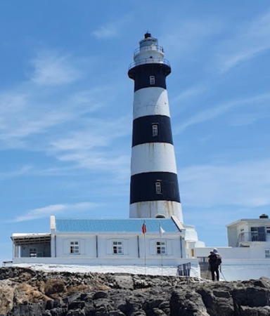
Lighthouses of Taiwan: Penghu Islands

Taiwan is a large island, nearly 400 km (250 mi) long, lying about 180 km (110 mi) off the coast of China. The island was claimed by the Chinese Empire in 1683 and some of its coastal regions at least were governed by China for more than 200 years. In 1895, following the first Sino-Japanese War, China ceded control of Taiwan to Japan. Japan governed the island until the end of the Second World War in 1945. While in power the Japanese constructed several lighthouses in Taiwan that remain active today. In 1949 the collapse of Nationalist forces in mainland China led to a new governmental separation between Taiwan and the mainland, with the Nationalist government, the Republic of China (Zhōnghuá Mínguó, 中華民國), on Taiwan and the Communist government, the People's Republic of China, on the mainland. This separation continues to the present day.

This page describes lighthouses of the Penghu (Pescadores) Islands, an archipelago of 90 islands and islets in the Taiwan Strait about 50 km (30 mi) west of Taiwan's southwest coast. The principal town, Magong, is accessible by air from Kaohsiung and by fast ferry from Budai. The islands are a resort area for Taiwanese but are seldom visited by Westerners. They are accessible by air or by ferry from Kaohsiung, Tainan, or Chiayi. The islands are administered as Penghu County, one of the 22 local government districts of Taiwan.

Lighthouses in Taiwan are operated by the Maritime and Port Bureau. The Bureau has adopted a program to restore and develop the light stations as tourist attractions.

There are many languages and dialects spoken in China, but Standard Chinese, often called Mandarin, is the primary language in Taiwan as it is on the mainland. The Chinese word for a lighthouse is dēngtǎ (灯塔). Jiao or chiao is a cape, dao, tao, yu, or hsu is an island, wan is a bay, and kang or gang is a harbor. Due to competing systems for transliterating Chinese into Latin characters there are always several possible spellings for the names of places in China. The Wade-Giles system was in use in Taiwan for many years, but at the beginning of 2009 the Pinyin system used on the mainland became the standard in Taiwan as well. At the present time most place names in Taiwan are still known under their Wade-Giles spellings: Keelung rather than Jilong, for example, and Kaohsiung rather that Gaoxiong.

ARLHS numbers are from the ARLHS World List of Lights. Admiralty numbers are from volume P of the Admiralty List of Lights & Fog Signals. U.S. NGA List numbers are from Publication 112.

General Sources
Lighthouses in Taiwan
Photos by various photographers available from Wikimedia.
World of Lighthouses - Taiwan
Photos by various photographers available from Lightphotos.net.
Online List of Lights - Taiwan
Photos by various photographers posted by Alexander Trabas.
Lighthouses in Taiwan
Wikipedia checklist, useful for its Pinyin spellings.
Leuchttürme auf Briefmarken
Postage stamp images posted by Klaus Huelse.
Navionics Charts
Navigational chart for the islands.


Dongjiyu Light, Wang'an, May 2017
Wikimedia Creative Commons photo by Tony kang peppy

Southern Penghu Lighthouses
* Qimei (Chimeiyu, Cimei, Chi Mei Yu, Ta Hsu) (2)
1965 (station established 1939). Active; focal plane 41 m (134 ft); two white flashes every 10 s. 8 m (26 ft) concrete post attached to a 1-story concrete keeper's house. Shih-Pei Chang has a closeup photo, Wikimedia has Ying-lung Lu's photo, Shen Wenjun has a 2021 photo, and Google has a street view and a satellite view of the station. In February 2015 the Bureau announced that the lighthouse will be renovated and opened to the public. Qimei (formerly called Ta Hsu) is the southernmost island of the Penghu Islands; it is accessible by ferry from Magong. Located in Qimei township, on the southern tip of the island. Site open, tower closed. . ARLHS TAI-006; Admiralty P4642; NGA 13888.
** Dongjiyu (Tungchi Yu, Chu-tou Hsu) (2)
1938 (station established 1911). Active; focal plane 67 m (220 ft); one long (2 s) white flash every 12 s. 20 m (66 ft) round cylindrical concrete tower with lantern and double gallery, attached to a 1-story concrete keeper's house. Lighthouse painted with black and white horizontal bands, lantern dome black. A photo is at the top of this page, E.J. Hsu has a 2022 photo, Lin Jingkai has a 2018 photo, and Google has a street view and a satellite view. The original lighthouse was a cast iron tower. Located at the northern end of the southeasternmost islet of the Penghu Islands, in Wang'an township about 25 km (15 mi) southeast of Wang'an. Accessible only by boat. Site open, tower open but no schedule information is available. . ARLHS TAI-031; Admiralty P4640; NGA 13884.
Wang'an Southwest
Date unknown. Active; focal plane about 13 m (43 ft); quick-flashing white light. Approx. 12 m (39 ft) round concrete tower with a large gallery mounted on a square concrete pier. Lighthouse painted with black and yellow bands. A photo is available and Google has a distant satellite view. Located on rocks at the end of a reef extending about 2.5 km (1.5 mi) from the southwestern tip of Wang'an. Accessible only by boat. Site open, tower closed. Admiralty P4644.6.
 
Huayu (Hua Hsu)
1939. Active; focal plane 65 m (213 ft); white flash every 5 s. 12.5 m (41 ft) round concrete tower with lantern and gallery. Lighthouse painted white, lantern dome black. A 2017 closeup photo is available, Brian Zhong has the photo seen at right, Sho Liang Chao has a 2021 photo, and Google has a street view and a satellite view. Huayu is the westernmost island of the Penghu archipelago, in Wang'an township about 27 km (16 mi) southwest of Yuwengdao. Located on the western side of the island. Accessible only by boat. Site status unknown. . ARLHS TAI-011; Admiralty P4646; NGA 13892.

Huayu Light, Wang'an, July 2015
Google Maps photo by Brian Zhong

Central Penghu Lighthouses
Chamuyu (Cha-Mou Hsu, Chamu)
1914 (largely rebuilt in 1949). Active; focal plane 25 m (82 ft); white flash every 6 s. 12 m (39 ft) octagonal concrete tower with gallery. Lighthouse painted with black and white vertical stripes. A good 2009 photo is available, Lin Davie has a 2022 photo, Liu Shikai has a 2019 photo, and Google has a satellite view. The lighthouse was heavily damaged by Allied bombers in World War II. Chamayu, in Huxi township, is about 4 km (2.5 mi) off the southeastern tip of the main island, Penghudao. Accessible only by boat. Site status unknown. ARLHS TAI-003; Admiralty P4650; NGA 13880.
Fou Wen (Chi-lung Yu, Magong) (2?)
Date unknown. Active; focal plane 14 m (46 ft); white flash every 4 s. 12 m (39 ft) round tapered concrete tower centered on a round 1-story concrete equipment shelter. Entire lighthouse is red. A closeup 2008 photo is available, Gao Xiaoyu has a distant street view from the neighboring Dome Island, and Google has a satellite view. Located on a reef off the entrance to Magong (Magong) City, the county seat of Penghu County, at the southwestern corner of Penghudao. This light, known as Fou Wen, was reported deactivated in 2014 and dropped by the Admiralty and NGA. When it returned to the lists in 2017 NGA listed it as Chi-ling Yu with the same characteristics and nearly the same location. It's not known whether the old light was reactivated or a new one was built. Accessible only by boat. Site open, tower closed. Admiralty P4651; NGA 13875 (ex-13876).
Haiqian Yu (Hai-Kan Yen, Black Rock)
Date unknown. Active; focal plane 9 m (30 ft); white flash every 6 s. 7.5 m (25 ft) triangular skeletal tower with an open lantern structure and gallery mounted on a stone base. Tower painted white, lantern black. A closeup photo is available, another photo is available, and Google has an indistinct satellite view. Located in a reef in Magong harbor. Accessible only by boat. Site open, tower closed. Admiralty P4654; NGA 13860.
*** Yuwengdao (Yu Weng Tao, Yuwongdao) (3)
1875 (station established 1778). Active; focal plane 61 m (200 ft); two long white flashes every 30 s. 11 m (36 ft) round cast iron tower with lantern and gallery. Lighthouse painted white, lantern dome black. Fog horn (blast every 30 s). Several 1-story keeper's houses. Alan Su's 2022 photo is at right, Andrew Jacobs has a 2008 photo, Wikimedia has a photo by Ying-lung Lu, Pintsung Yao has a 2021 photo, Liao Jianmin has a street view, and Google has a satellite view. The original light was established in a tower of a pagoda. In 1828 the pagoda was rebuilt, with a higher tower for the light. The present lighthouse was designed by the British engineer David Marr Henderson and installed under contract to the Chinese Imperial government. Fortunately it suffered only minor damage in World War II. Yuwengdao, in Xiyu township, is the westernmost of the main islands of Penghu; it is accessible by bridge from Magong. Located at the southwestern tip of the island, near the village of Waian. Site open, tower open daily except Mondays year round. . ARLHS TAI-037; Admiralty P4652; NGA 13872.
* [Xiaomenyu (Hsiao-men Yu) (1 and 2)]
Date unknown. Active; focal plane at least 25 m (82 ft); white light, pattern unknown. 6 m (20 ft) concrete post formerly painted with black and yellow horizontal bands but the light tower is all white in Lin Hongyu's 2022 photo and a 2021 Instagram photo. Google has an indistinct satellite view. Next to the active light is an older white concrete beacon of roughly the same height. Chris Yang has a photo showing the older daymark pattern, a distant view is available, and Google has a 2017 street view. The light stands on a very popular viewpoint. Located at the western tip of Xiaomenyu, an island on the north side of Yuwengdao. Accessible by road. Site open, tower closed. . Admiralty P4648.

Yuwengdao Light, Xiyu, July 2022
Google Maps photo by Alan Su
* [Jianyu]
Date unknown. Active; focal plane at least 25 m (82 ft); white light, pattern unknown. 7 m (23 ft) concrete post painted with red and white (formerly black and white) horizontal bands. Lin Jingkai has a closeup photo and Google has a 2020 street view and a distant satellite view. In 2021 the tower was repainted in brightly colored patterns as seen in this Instagram photo. Like the Xiaomenyu beacon, this light stands on a very popular viewpoint. The Admiralty lists this light as Chung-t'un Yu Northward. Located at the eastern tip of an island about 8 km (5 mi) north of Magong. Accessible by road. Site open, tower closed. . Admiralty P4657.2.
[Zhongtun (Chung-t'un Yu)]
Date unknown. Active; focal plane at least 20 m (66 ft); white light, pattern unknown. 7 m (23 ft) concrete post painted with black and white horizontal bands. Google has a 2023 street view and a distant satellite view. Located in a wind farm at the northeastern tip of Zhongton about 5 km (3 mi) north of Magong. Site status unknown but the light can be seen from the street. Admiralty P4657.3.
* Penghudao (P'eng-hu Tao) (1 and 2)
Date unknown. Active; focal plane at least 30 m (98 ft); white light, pattern unknown. The active light is on a 6 m (20 ft) concrete post painted with black and yellow horizontal bands. Near this light is the original beacon, an 8 m (26 ft) round strongly conical concrete tower with an attached concrete stairway. Sam Hsieh has a 2021 photo, ChiaoHsun Hsu has a 2018 street view and Google has an indistinct satellite view. Located on heights at the northeastern tip of the main island of Penghu. Site open, tower closed. Admiralty P4657.7.

Northern Penghu Lighthouse
* [Jebei (Chi-pe Yu)]
Date unknown. Active; focal plane at least 20 m (66 ft); white light, pattern unknown. 7 m (23 ft) concrete post painted with black and white horizontal bands. Xu Minghong has a 2021 photo, Fang Hongcheng has a 2023 photo, and Google has a street view and a satellite view. Located on the southwestern tip of Jebei, the northernmost major island of Penghu. Accessible by road. Site open, tower closed. Admiralty P4657.5
Mudouyu (Mu Tou Hsu, Mu Tou Yu)
1902. Active; focal plane 49 m (161 ft); white flash every 20 s. 40 m (131 ft) round cast iron tower with double gallery; the original lantern has been removed. Lighthouse painted with black and white horizontal bands. The 1-story keeper's house is staffed. Lin Youlong has the 2021 photo seen at right, an excellent closeup photo is available, Mike Lin also has a good photo, Chichuen Wong has a street view, and Google has a satellite view. This historic tower is Taiwan's tallest lighthouse. Mudouyu is a tiny islet in Baisha township at the extreme northern end of the Penghu chain, about 12 km (7.5 mi) north of Baisha. Accessible only by boat. Site open, tower closed. Site manager: Penghu National Scenic Area. . ARLHS TAI-017; Admiralty P4658; NGA 13856.

Mudouyu Light, Baisha, May 2021
Google Maps photo by Lin Youlong

Information available on lost lighthouses:

Notable faux lighthouses:

Adjoining pages: East: Western Taiwan | Southeast: Southern Taiwan | West: Matsu and Kinmen

Return to the Lighthouse Directory index | Ratings key

Posted September 11, 2007. Checked and revised March 21, 2024. Lighthouses: 10. Site copyright 2024 Russ Rowlett and the University of North Carolina at Chapel Hill.