Lighthouses of East Ukraine: Sea of Azov

The Directory's pages for Ukraine describe the lighthouses as they existed before the start of the current conflict between Ukraine and Russia. No changes will be made until there is a stable agreement that stops the fighting. Russian occupied territories in Ukraine are identified as East Ukraine.

Ukraine (officially Україна, Ukraina) is a large country on the north side of the Black Sea, bordering Russia to the east. Except for a brief period of independence during the Russian Revolution (1917-20) Ukraine was part of Russian or Soviet empires from the mid seventeenth century until the collapse of the Soviet Union in 1991. Meanwhile the coastline of the Black Sea was mostly under the control of the Ottoman (Turkish) Empire until it was taken by Russia during a series of wars in the second half of the 1700s.

The Black Sea's northern coast is in several sections. In the west is the Bight of Odessa, named for Ukraine's largest port. In the center is the diamond-shaped peninsula of Crimea. To the east is the Sea of Azov, connected to the rest of the Black Sea by the narrow Kerch Strait at the eastern end of Crimea.

In March 2014 Russia annexed Crimea, separating the Ukrainian coast into two sections: one on the Bight of Odessa in the west and one on the the northwestern side of the Sea of Azov in the east. The annexation of Crimea has not been accepted by Ukraine or recognized internationally. Important note: The Lighthouse Directory takes no position on any international dispute; our task is to describe lighthouses, not comment on politics. Our descriptions are of the actual situation, whatever it may be.

Ukraine (without Crimea) is divided into 24 regions called oblasts (область) This page describes Ukraine's lighthouses on the Sea of Azov in the regions of Donets'ka, Zaporizʹka, and southeastern Khersons’ka. Separatists supported by Russian troops occupy the easternmost part of the Donets'ka region.

The Ukrainian word for a lighthouse is mayak (маяк); ostriv (острів) is an island, mys (мис) is a cape, richka (річка) is a river, and havan' (гавань) is a harbor.

Lighthouses in Ukraine are maintained by Derzhhidrohrafiyu (Держгідрографія) the hydrography and navigation service of the Ministry of Transport and Communications.

ARLHS numbers are from the ARLHS World List of Lights. UA numbers are the Ukrainian light list numbers as reported by Ukrainian Lighthouses on the Air. Admiralty numbers are from volume N of the Admiralty List of Lights & Fog Signals. U.S. NGA List numbers are from Publication 113. The Ukrainian light list, Вогні і знаки Чорного та Азовського морів (Lights and Signs of the Black and Azov Seas), is not available online.

General Sources
Derzhhidrohrafiyu - Lighthouses
Photos and historical information on the Ukrainian State Hydrography web site.
Lighthouses in Ukraine
The ARLHS Ukraine listing; photos contributed by Ukrainian amateur radio operators are available for many of the lighthouses.
Lighthouses in Ukraine
Photos by various photographers available from Wikimedia.
World of Lighthouses - Ukraine
Photos by various photographers available from Lightphotos.net.
Online List of Lights - Ukraine
Photos by various photographers posted by Alexander Trabas.
Russische Leuchttürme auf historischen Postkarten
Historic postcard images posted by Klaus Huelse. Ukrainian lighthouses are near the bottom of the page.
Ukraine and Crimea
Historic postcard images posted by Michel Forand.
Navionics Charts
Navigational chart for the Sea of Azov.

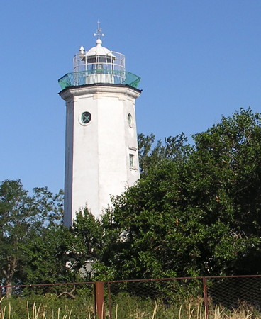
Berdyans'k Verkhniy Light, Berdyans'k, June 2012
Wikimedia Creative Commons photo by Andrew Butko
Donets'ka Region (Mariúpol Area) Lighthouses
Following the Russian annexation of Crimea in March 2014 a rebellion by pro-Russian forces broke out in eastern Donets'ka. For several months the city of Mariúpol was occupied by rebel forces but by mid-summer the area was retaken by the Ukrainian military. Fighting continued intermittantly a short distance east of the city. By 2018 the cease-fire line between opposing forces was roughly 20 km (13 mi) east of Mariúpol.

Azovstal East Mole
Date unknown. Active; focal plane about 16 m (52 ft); two green flashes every 5 s. Approx. 8 m (26 ft) round tower with a round or square base, painted green with one white horizontal band. No photo available but Google has an indistinct satellite view. Port Azovstal, located on the east bank of the Kalmius River about 5 km (3 mi) east of Mariúpols traditional waterfront, serves the giant Azovstal steel works, the largest steel plant in Ukraine and one of the largest in the former Soviet Union. Located on an extension of the short east mole of the harbor. Site and tower closed. Admiralty N5516; NGA 18752.
Azovstal Range Front
Date unknown. Active; focal plane 22 m (72 ft); continuous green light visible only on the range line. 22 m (72 ft) square skeletal tower carrying a white slatted daymark with a black vertical stripe. No photo available but Google has a satellite view. Located on the east side of the mouth of the Kalmius River. Site and tower closed. ARLHS UKR-085; UA-4720; Admiralty N5510; NGA 18756.
Azovstal Range Middle
Date unknown. Active; focal plane 53 m (174 ft); continuous green light visible only on the range line. 37 m (121 ft) square skeletal tower carrying a white slatted daymark with a black vertical stripe. No photo available but Google has a good satellite view. Located beside the main railroad line in the middle of the steel plant. Site and tower closed. ARLHS UKR-086; UA-4721; Admiralty N5510.1; NGA 18760.
Azovstal Range Rear
Date unknown. Active; focal plane 66 m (217 ft); continuous green light visible only on the range line. 34 m (112 ft) square skeletal tower carrying a white slatted daymark with a black vertical stripe. No photo available but Google has a satellite view. Located beside the highway entrance on the east side of the steel plant. Site and tower closed. ARLHS UKR-087; UA-4722; Admiralty N5510.2; NGA 18764.
Mariúpol East Entrance (Avanport) (Range Front)
Date unknown. Active; focal plane 20 m (66 ft); red light, 1 s on, 1 s off, visible only on the former range line. 19 m (62 ft) square skeletal tower, painted black. No photo available but Bing has a satellite view. The rear light of the range has been discontinued and apparently removed, its function replaced by the leading light on the front tower. The East Entrance is the traditional entrance between the Old Gate moles (see below). Located at the foot of a pier about 1 km (0.6 mi) northeast of the West Entrance Range Front Light. Site and tower closed. ARLHS UKR-089; UA-4665; Admiralty N5484; NGA 18724.
#Mariúpol East Entrance (Avanport) Range Rear
Date unknown. Inactive since 2009 and later demolished. This light was listed as a 13 m (43 ft) square tower on a white "dwelling," according to NGA. No photo available and the light is not seen in this Google satellite view. This light was deactivated when the front light became a directional light. The location of this light is about 200 m southwest of the West Entrance Range Middle lighthouse. Site status unknown. ARLHS UKR-090; ex-UA-4666; ex-Admiralty N5484.1; ex-NGA 18728.
Mariúpol (Old Gate) North Mole
Date unknown (station established 1891). Active; focal plane 9 m (30 ft); green flash every 3 s. 9 m (30 ft) hexagonal tower with lantern and gallery, attached to a 1-story equipment house. Entire lighthouse painted green. This light is on the left in Vladimir Ryazantsev's photo and Google has a distant satellite view. Huelse has a postcard view of one of the original lights, but we don't know which mole it was on. Mariúpol is a major port just inside the entrance to Taganrogsky Bay, an estuary at the northeast corner of the Sea of Azov that forms the mouth of the Don River. Port Mariúpol is an industrial harbor on the south side of the city. The narrow entrance between the two moles is called the Old Gate. Located at the northern end of the detached South Breakwater. Accessible only by boat. Site and tower closed. Admiralty N5490; NGA 18720.
Mariúpol (Old Gate) South Mole
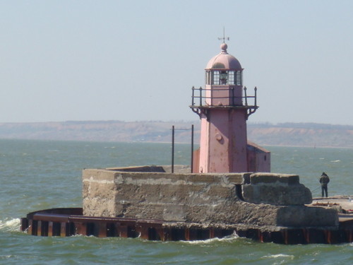
Date unknown (station established 1891). Active; focal plane 9 m (30 ft); red flash every 3 s. 9 m (30 ft) hexagonal tower with lantern and gallery attached to a 1-story equipment house. Entire lighthouse painted red. A photo is at right, the light is on the right in Vladimir Ryazantsev's photo, and Google has a satellite view. Located at the northern end of the detached South Breakwater. Accessible only by boat. Site and tower closed. ARLHS UKR-024; Admiralty N5492; NGA 18716.
Old Gate North Mole Light
Old Gate South Mole Light, Port Mariúpol, April 2009
ex-Panoramio photo copyright -=MNA=-; permission requested
Mariúpol West Entrance (Port Mariúpol) Range Front
Date unknown. Active; focal plane 27 m (89 ft); two continuous green lights, one above the other, visible only on the range line; for general navigation there is also a white light, 1 s on, 1 s off, at a focal plane of 19 m (62 ft). Approx. 24 m (79 ft) square skeletal tower, painted black. The tower also carries a large slatted daymark painted white with a red vertical stripe. Aleks Zenin has a photo and Google has a satellite view. The range guides ships in a long dredged channel leading to Port Mariúpol. Located on a building materials quay, not far from the Old Gate mole lights. Site and tower closed. UA-4530; Admiralty N5478; NGA 18732.
* Mariúpol West Entrance (Port Mariúpol) Range Middle
Date unknown. Active; focal plane 57 m (187 ft); a continuous red light is shown on the range line, but for general navigation a red light with one brighter flash and one occultation every 4.5 s is shown. 23.5 m (77 ft) square cylindrical brick tower with double gallery, rising from the front of a 2-story brick building. Lighthouse painted white with a black vertical stripe. Artem Tarasov has a good 2018 photo, another photo is available and Google has a satellite view. Located a short distance north of the Port Mariúpol waterfront. Site open, tower closed. UA-4531; Admiralty N5478.1; NGA 18736.
Mariúpol West Entrance (Port Mariúpol) Range Rear
Date unknown. Active; focal plane 86 m (282 ft); two continuous red lights, one above the other, visible only on the range line. 21 m (69 ft) triangular pyramidal skeletal tower, painted black. ARLHS has a photo by radio amateur US6IQ but the tower is not seen in Google's satellite view. Located about 1 km (0.6 mi) north of the middle light. Site status unknown. ARLHS UKR-091; UA-4532; Admiralty N5478.2; NGA 18740.
* Belosaray (Belosarayskiy Kosa)
1836. Active; focal plane 21 m (69 ft); white light,1.5 s on, 1.5 s off, 1.5 s on, 4.5 s off. 19 m (62 ft) octagonal stone tower with lantern and gallery, attached to the seaward side of a 1-story masonry keeper's house. Lighthouse painted white. Andrew Butko's photo is at right, Lightphotos.net has a 2013 photo, Klim Chernikov has a good photo, Forand has a historic postcard view, and Google has a satellite view. This lighthouse, the oldest on the Sea of Azov, was built at the end of the easternmost of the four major sand spits on the north side of the sea. Since 1836, however, the spit has lengthened westward about 2.5 km (1.5 mi). Like all of the Azov Sea lighthouses, it was heavily damaged during World War II and had to be repaired extensively in 1955. Located about 28 km (17.5 mi) southwest of Mariúpol. Site open, tower closed. ARLHS UKR-002; UA-4300; Admiralty N5472; NGA 18680.
Belosaray Light
Belosaray Light, Mariúpol, September 2007
Wikimedia Creative Commons photo by Andrew Butko
Zaporizʹka Region (Berdyans'k Area) Lighthouses
Berdyans'k is a substantial port on the central north coast of the Sea of Azov, due north of the Kerch Strait.
Berdyans'k Nizhniy (Lower Berdyans'k) (2)
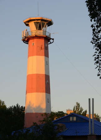
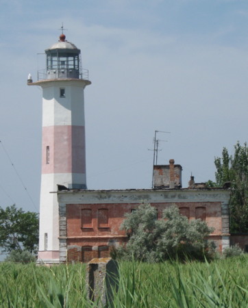
1956 (station established 1838). Active; focal plane 24 m (79 ft); white light, 4.5 s on, 3 s off. Approx. 22 m (72 ft) octagonal masonry tower with lantern and gallery, attached to a 2-story masonry keeper's house. It appears that the light is now displayed from the gallery rail. Lighthouse painted with red and white horizontal bands. Olya Usova's photo is at right, Lightphotos.net has a 2012 photo, Maksim Emel'yanov has a 2015 photo, Dmytro Zuyenko has a 2017 closeup photo, Huelse has a historic postcard view, and Google has a street view and a satellite view of the station. The original light, described as a five-story building, was probably somewhat shorter. Heavily damaged in World War II, it was first patched up and then replaced in 1956. The lantern appears older; it may have come from the earlier lighthouse. Located at the end of a long, hook-shaped spit about 10 km (6 mi) south of Berdyans'k. Accessible only by boat and perhaps by 4WD. Site status unknown. UA-4280; Admiralty N5454; NGA 18640.
Berdyans'k (Podkhodnyy Kanal) Range Front (?)
Date unknown. Inactive since 2018 and possibly demolished. 29 m (95 ft) square skeletal tower carrying a white lantern. No photo available but Google has an indistinct satellite view. The Admiralty listed this as the middle light but NGA calls it the front light. It was deactivated in 2018 when the rear light became a directional light. Located in the commercial harbor district of Berdyans'k. Site and tower closed. ARLHS UKR-003; ex-Admiralty N5464; NGA 18660.
* Berdyans'k (Podkhodnyy Kanal) Range Rear (2)
Date unknown. Active; focal plane 63 m (207 ft); red light, continuous, flashing once every 2 s, or occulting once every 2 s, depending on direction. 20 m (66 ft) (?) steel post on a square concrete base carrying a large slatted daymark painted white with a black vertical stripe. A similar black and white daymark is painted along the slope below the lighthouse. Sergey Passat has a photo, Artyr Oxota has a 2018 photo, and Google has a street view and a satellite view. This light replaced a square skeletal tower seen in Aleksandr Musafirov's photo. Located on Pravdy Street atop a steep bluff 1.3 km (3/4 mi) northeast of the front light. Site open, tower closed. ARLHS UKR-004; Admiralty N5464.1; NGA 18664.
* Berdyans'k Verkhniy (Upper Berdyans'k) (1)
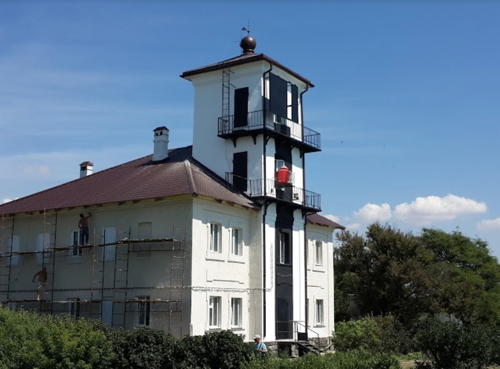
1883. Inactive. Approx. 11 m (36 ft) square cylindrical masonry tower rising from the front of a 1-story brick keeper's house. Tower painted white; the house is unpainted red brick. No photo available but Google has a satellite view. The lighthouse was repaired after being heavily damaged in World War II. We don't know the present use of the building. Located about 100 m (110 yd) northeast of the active lighthouse. Site open, tower closed.
Berdyansk Nizhniy Light
Berdyans'k Nizhniy Light, Berdyans'k, July 2009
ex-Panoramio Creative Commons photo by Olya Usovaツ
* Berdyans'k Verkhniy (Upper Berdyans'k) (2)
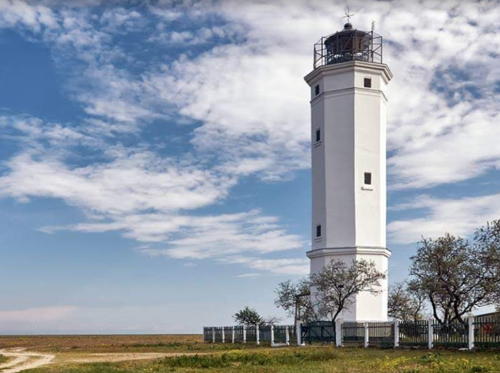
1977 (station established 1883). Active; focal plane 72 m (236 ft); three red flashes every 9.4 s. 33 m (108 ft) octagonal masonry tower with lantern and gallery, painted with red and white horizontal bands. Andrew Butko's photo is at the top of this page, Lev Sandalov has a photo, Tanya Dubinina has a 2017 photo, Wikimedia has several good photos, and Google has a street view and a satellite view. Located on a bluff about 400 m (1/4 mi) north of the beach and about 2.5 km (1.5 mi) northwest of the port area of Berdyans'k. Site open, tower closed. UA-4187; Admiralty N5458; NGA 18648.
Obitochnyy (Obitochnaya Kosa) (2)
Date unknown. Active; focal plane 13 m (43 ft); white light, 1.5 s on, 6.5 s off. 12 m (39 ft) rectangular cylindrical skeletal tower. A photo is available and Bing has an indistinct satellite view of the station. Located near the end of the Obitochny Spit, about 75 km (45 mi) southwest of Berdyans'k. Site open, tower closed. ARLHS UKR-109; Admiralty N5452; NGA 18632.
* Novokonstantinovskiy (Camp Mayak)
Date unknown. Active; focal plane 31 m (102 ft); white flash every 6 s. 22 m (72 ft) square cylindrical skeletal tower with gallery, mounted at one end of a 3-story dormitory building. Tower painted red. John Samples has a photo but the tower is not seen clearly in Google's satellite view. At the time of Samples's photo (July 2003), this former Soviet facility was in use as a Christian summer camp operated by an American charity. It continues as a Christian summer camp although the connection to America seems to have been lost. Located on the coast at Novokonstantinovka, about 35 km (22 mi) southeast of Melitopol. Site open, tower closed. Site manager: Azov Lighthouse Christian Wellness Center. ARLHS UKR-094; UA-4170; Admiralty N5448; NGA 18628.

Southeastern Khersons’ka Region: Henichesʹk Area Lighthouses
Khersons’ka also has a southwestern coast on the Bight of Odessa; lighthouses of that coast are described on the Dnipro Basin page.
Biryuchiy (Ostrov Biryuchiy)
1882. Active; focal plane 27 m (89 ft); two long (1.5 s) white flashes every 7.5 s. 25 m (82 ft) octagonal masonry tower, painted white. Olexiy Zozulya has the excellent 2019 photo seen at right, Wikimedia has a photo, there's a distant view from the sea, Google has a closeup street view, and Bing has a satellite view. This lighthouse is in the Azov-Syvash National Park. Heavily damaged during World War II, it was not returned to service until 1957. It was the last lighthouse on the Sea of Azov to be connected to external power, in 1993. Located at the tip of a long sand spit (westernmost of the four on the north coast of the Sea of Azov) about 15 km (9 mi) southeast of Heniches'k. May be accessible only by boat. Site status unknown. ARLHS UKR-005; UA-4135; Admiralty N5436; NGA 18608.

Biryuchiy Light, Azov-Syvash National Park, January 2019
Google Maps photo by Olexiy Zozulya
* Genicheskiy (Henichesʹk)
1883. Active; focal plane 21 m (69 ft); white flash every 5 s; there is also a continuous red light with a lower focal plane. 12 m (39 ft) square cylindrical masonry tower rising at the front of a 2-story masonry keeper's house. Lighthouse painted white with a black vertical stripe. Ruslan Korkin has the 2016 photo at right, Yevhen Bill has a 2016 photo, Huelse has a historic postcard view, Forand has the same postcard view, Alexey Voitsekhovsky has a winter street view, and Google has a satellite view. The lighthouse was completed in 1879 but it was not lit until 1883. It was damaged during World War II but placed back in service by 1944. The building was restored and renovated in 1961. According to a Ukrainian Wikipedia article on Henichesʹk, the lighthouse was "illegally occupied" by Russian troops during the 1990s. Located on the beach at Henichesʹk, a town at the extreme western end of the Sea of Azov. Site open, tower closed. ARLHS UKR-019; UA-4140; Admiralty N5438.

Information available on lost lighthouses:

Notable faux lighthouses:


Genicheskiy Light, Henichesʹk, July 2016
Google Maps photo by Ruslan Korkin

Adjoining pages: East: Russia: Sea of Azov | South: Eastern Crimea | West: Ukraine: Dnipro Basin

Return to the Lighthouse Directory index | Ratings key

Posted February 19, 2007. Checked and revised August 11, 2021. Lighthouses: 21. Site copyright 2021 Russ Rowlett and the University of North Carolina at Chapel Hill.