Lighthouses of the United States Virgin Islands

The Virgin Islands of the United States, typically called the U.S. Virgin Islands (USVI), are a group of islands in the West Indies located east of Puerto Rico. There are three main islands. Saint Thomas and Saint John are part of the main chain of the Virgin Islands Archipelago, while Saint Croix is a larger island about 65 km (40 mi) to the south. The islands were a Danish colony, the Danish West Indies, from 1754 until they became somewhat isolated from Danish rule during World War I. In 1917 the United States purchased the islands from Denmark. The population of the islands is about 90,000.

Shortly before the change in sovereignty Denmark built two lighthouses in the colony. These two lights are among the most endangered of all U.S. lighthouses today. The U.S. installed a third light at Fort Louise Augusta near Christiansted, St. Croix, and the photo below by Shawn and Kris McCourt proves that this lighthouse still stands (special thanks to Shawn's father, George McCourt, for sending this photo). A fourth light was at Muhlenfeldt Point, the southeastern entrance to the harbor of Charlotte Amalie, St. Thomas. Nothing remains of this light station.

Aids to navigation in the U.S. Virgin Islands are maintained by the Aids to Navigation Team of the U.S. Coast Guard Sector San Juan, Puerto Rico.

ARLHS numbers are from the ARLHS World List of Lights. Admiralty numbers are from Volume J of the Admiralty List of Lights & Fog Signals. USCG numbers are from Volume III of the U.S. Coast Guard Light List, and U.S. NGA numbers are from Publication 110.

General Sources
Online List of Lights - Virgin Islands West and East
Photos by various photographers posted by Alexander Trabas. Lights of St. Thomas and St. John are on the West page and lights of St. Croix are on the East page.
World of Lighthouses - U.S. Virgin Islands
Photos by various photographers available from Lightphotos.net.
U.S. Virgin Islands Lighthouses
Aerial photos posted by Marinas.com.
Leuchttürme Mittelamerikas und der Karibik auf historischen Postkarten
Historic postcard views posted by Klaus Huelse.
U.S. Coast Guard Navigation Center: Light Lists
The USCG Light List can be downloaded in pdf format.
NOAA Chart 25641 - Virgin Islands
Official navigation chart for the islands.
Navionics Charts
Navigation chart for the islands.


Buck Island Light, St. Thomas, August 2011
ex-Panoramio Creative Commons photo by Roberto Cofresi

St. Thomas Lighthouses
Savana Island
Date unknown. Active; focal plane 300 ft (91 m); white flash every 4 s. Described by USCG only as a "white tower," no tower height given. No photo available and the tower is hidden by trees in Google's satellite view. To be seen over the trees of the island the light is probably a square skeletal tower perhaps as much as 65 ft (20 m) tall. Savana is an rugged island about 1 mi (1.6 km ) long and about 3 miles (5 km) off the eastern tip of St. Thomas. The light marks the east side of the Virgin Passage, the deepwater channel between St. Thomas and the Puerto Rican island of Culebra. Located near Virgin Point, the southwestern tip of the island. Accessible only by boat and there are no landing facilities. Site status unknown. Owner/operator: U.S. Coast Guard. Admiralty J5610; USCG 3-31690; NGA 14604.
[Berg Hill Range Front (2)]
Date unknown. Active; focal plane 210 ft (64 m); green flash every 2.5 s. Approx. 20 ft (6 m) square skeletal tower. Trabas has Arndt's photo and Google has a fuzzy satellite view. Huelse has a historic postcard view of the earlier lighthouse, a square concrete tower. This is the entrance range for St. Thomas Harbor. Located on the steep slope of Berg Hill above Catherine Berg Road. Site status unknown. Owner/operator: U.S. Coast Guard. Admiralty J5618; USCG 3-32575; NGA 14624.
[Berg Hill Range Rear (2)]
Date unknown. Active; focal plane 299 ft (91 m); green light, 3 s on, 3 s off. Approx. 20 ft (6 m) square skeletal tower. Trabas has Arndt's photo and Google has a fuzzy satellite view. Located upslope 378 ft (115 m) north northwest of the front light. Site status unknown. Owner/operator: U.S. Coast Guard. Admiralty J5618.1; USCG 3-32580; NGA 14628.
Buck Island (1)
1913. Inactive since the mid 1990s. 25 ft (8 m) square steel tower with lantern and gallery, attached to a small service room. The lighthouse was painted white and the lantern black, although nearly all the paint has weathered off the rusty building. Roberto Cofresi's photo is at the top of this page, Nick Heinemann has a 2021 drone view, Jeff Johnson has a 2009 closeup photo, Trabas has Rainer Arndt's photo, a 2007 view from the sea is available, the Coast Guard has a historic photo, and Google has a satellite view. This lighthouse was built by the Danish government shortly before the islands became a U.S. territory in 1917. Critically endangered, the lighthouse was added to the Lighthouse Digest Doomsday List in April 2004. Located at the highest point of Buck Island, about 3 mi (5 km) south of St. Thomas. The island has been a wildlife refuge since 1969. The refuge is closed to the public as a bird sanctuary. Site and tower closed. Owner: U.S. Fish and Wildlife Service. Site manager: Buck Island National Wildlife Refuge. ARLHS VIR-002.
Buck Island (2)
1990s. Active; focal plane 139 ft (42 m); white flash every 4 s. Approx. 40 ft (12 m) square cylindrical steel skeletal tower. A photo is at the top of this page, Trabas has Rainer Arndt's photo and a 2007 view from the sea is available. Located adjacent to the historic lighthouse. Site open, tower closed. Owner/operator: U.S. Coast Guard. Admiralty J5628; USCG 3-32565; NGA 14632.

St. Croix Lighthouses
* Hams Bluff (1)
1915. Inactive since about 2010. Approx. 35 ft (10.5 m) cast iron tower. Two 1-story concrete keeper's houses are now owned by the U.S. Navy. Seba Lanza's 2023 photo is at right, Patrick Bryant has a 2021 photo, Wikimedia has a 2014 photo, Aaron Paden has a 2009 photo, Marinas.com has an aerial photo, a distant view is available, the Coast Guard has a historic photo, and Google has a 2016 street view and a satellite view. This lighthouse was built by the Danish government shortly before the islands became a U.S. territory in 1917. Critically endangered by lack of maintenance, the lighthouse was added to the Lighthouse Digest Doomsday List in April 2004. The former Coast Guard Historian site said the lighthouse was deactivated in the mid 1990s but Stanley Sneed has a 2007 photo showing the lighthouse still in service. Located on the northwestern coast of St. Croix, marking the approach to the harbor of Fredericksted. The lighthouse is accessible by hiking a short trail from the end of Hams Bluff Road (after walking around a fenced area). Parking is limited. Site open, tower closed. Site manager: U.S. Navy. . ARLHS VIR-001.

Hams Bluff Light, St. Croix, April 2023
Instagram photo by SebaLanza
* Hams Bluff (2)
2010 (?). Active; focal plane 394 ft (120 m); two white flashes, separated by 10 s, every 30 s. Approx. 30 ft (9 m) square cylindrical skeletal tower. The new tower is behind the old one in the photo above right. Located adjacent to the historic lighthouse. Site open, tower closed. Owner/operator: U.S. Coast Guard. Admiralty J5640; USCG 3-32845; NGA 14656.
* Fort Louise Augusta (Christiansted Entrance Range Front) (1)
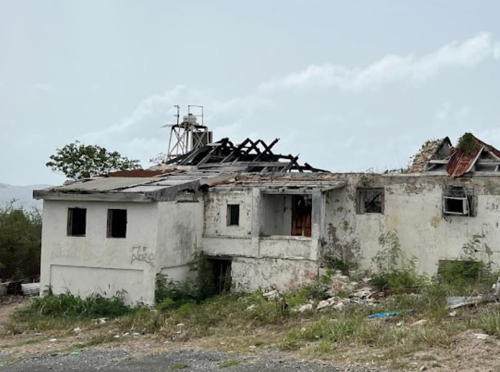
1919 (station established 1857). Inactive since 1931. 1-story concrete keeper's house, formerly with a lantern mounted at one end. The building was painted white with a red corrugated metal roof, as seen in a 2008 photo contributed by Shawn and Kris McCourt. Michael Thomas's 2022 photo at right shows the building unroofed and heavily damaged, damage probably caused by Hurricane Maria in September 2017. The active range light (focal plane 48 ft (14.5 m); quick-flashing green light) is mounted on a 17 ft (5 m) square skeletal tower next to the house. Don Wiss has posted a panorama of Christiansted harbor in which the active lighthouse appears at the far right, and Google has a sea view and a satellite view. The original light here was shown from a mast on the fort. Located on a promontory at the north end of Christiansted harbor. Accessible by road; the McCourts report the site is not easy to find, so local assistance is suggested. Site open, tower closed. Owner/operator: U.S. Coast Guard. Site manager: unknown. ARLHS VIR-006. Active light: Admiralty J5642; USCG 3-32870; NGA 14664.
Christiansted Entrance Range Rear
Date unknown. Active; focal plane 90 ft (27.5 m); green light, 3 s on, 3 s off. Approx. 50 ft (15 m) square skeletal tower. No photo available but Google has an indistinct satellite view and a very distant street view. Located on a hillside 0.41 mi (660 m) south southeast of the front light. Site status unknown. Admiralty J5642.1; USCG 3-32875; NGA 14668.
* Southwest Cape
Date unknown. Active; focal plane 45 ft (14 m); white flash every 6 s. Approx. 33 ft (10 m) square cylindrical skeletal tower. Google has a street view and an indistinct satellite view. Located beside Tranberg Road at the southwestern tip of St. Croix. Site open, tower closed. Owner/operator: U.S. Coast Guard. Admiralty J5638; USCG 3-33340; NGA 14688.

Information available on lost lighthouses:

  • Muhlenfeldt Point (1844-?), St. Thomas. Huelse has a postcard view of the second (1912) lighthouse. The site of this lighthouse is occupied now by a Marriott beach resort. ARLHS VIR-005.

Fort Louise Augusta Light, St. Croix, July 2022
Google Maps photo by Michael Thomas

Notable faux lighthouses:

Adjoining pages: East: British Virgin Islands | West: Puerto Rico

Return to the Lighthouse Directory index

Created May 2002. Checked and revised January 10, 2024. Lighthouses: 8. Site copyright 2024 Russ Rowlett and the University of North Carolina at Chapel Hill.