Lighthouses of the United States: Vermont

The United States of America is a federal union of 50 states and a capital district. As its name suggests the state of Vermont is located in the Green Mountains (monts verts in French) south of the Canadian border and northeast of New York. Rejecting claims to the territory by New Hampshire and New York, residents organized the independent Vermont Republic in 1777 (during the Amerucan Revolution). In 1791 Vermont was admitted to the United States as the 14th state, the first to be added to the original 13.

Vermont is far from the ocean but the state has half a dozen lighthouses nonetheless. The lighthouses are on the eastern side of Lake Champlain, which is part of an international waterway connecting the St. Lawrence and Hudson Rivers. The lake drains northward to the St. Lawrence through the Richelieu River and it is connected southward to the Hudson by the Champlain Canal, opened in 1823.

There are six more lighthouses on the west side of the lake in the state of New York. For almost 70 years none of the Lake Champlain lighthouses were active but starting in 2002 the Coast Guard reactivated several lighthouses in each state. Lighthouse Digest has Jeremy D'Entremont's December 2002 article on the relighting effort.

At one time there were also three lighthouses on the Vermont side of Lake Memphremagog, but none of these towers have survived.

Navigational aids in the United States are operated by the U.S. Coast Guard but ownership (and sometimes operation) of historic lighthouses has been transferred to local authorities and preservation organizations in many cases. Lighthouses on Lake Champlain are operated by the Aids to Navigation Team at Coast Guard Station Burlington, part of the Coast Guard First District.

ARLHS numbers are from the ARLHS World List of Lights. USCG numbers are from Vol. I of the USCG Light List.

General Sources
New England Lighthouses: A Virtual Guide - Vermont
Outstanding historical accounts and photos by Jeremy D'Entremont.
Vermont Lighthouses
Excellent photos and historical accounts posted by Kraig Anderson.
Lighthouses in Vermont
Photos by various photographers available from Wikimedia.
Leuchttürme USA auf historischen Postkarten
Historic postcard images of U.S. lighthouses posted by Klaus Huelse.
Lake Memphremagog Lighthouses
Historic postcard images posted by Michel Forand.
U.S. Coast Guard Navigation Center: Light Lists
The USCG Light List can be downloaded in pdf format.
NOAA Nautical Charts
Official nautical charts for the coast can be viewed online.
Navionics Charts
Navigation chart for Lake Champlain.


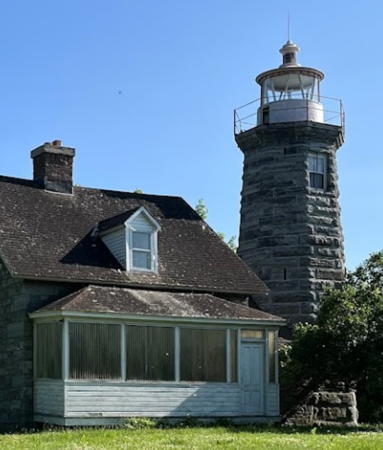
Windmill Point Light, Alburg, June 2023
Google Maps photo by Maksim Mercuri

Addison County Lighthouse
Diamond Island
Date unknown. Active; focal plane 37 ft (11 m); white flash every 2.5 s. 36 ft (11 m) square skeletal tower. NOAA automatic weather station. A photo is available and Google has a satellite view. Located on a reef in the middle of the lake off Grosse Point in Ferrisburgh Township. Accessible only by boat. Site open, tower closed. USCG 1-39825.

Chittenden County (Burlington Area) Lighthouses
**** Colchester Reef (1) (relocated)
1871 (Albert Dow, designer). Inactive since 1933 (a decorative light is displayed). 35 ft (11 m) square cylindrical wood tower with lantern and gallery, mounted on a 2-story wood keeper's house. The original fog bell is mounted beside the tower. Keith Ewing's photo is at right, Anderson also has a good page for the lighthouse, another fine photo is available, Eliezer Alkalay has a 2022 photo, and Google has a street view and a satellite view. The Coast Guard has a historic photo of the lighthouse at its original location on a square crib southwest of South Hero Island and about 7 miles (11 km) northwest of Burlington. The designer, Albert Dow, was a Vermont native. Numerous lighthouses of his design were built, including Rose Island, Sabin Point, and Pomham Rocks in Rhode Island, Bridgeport Harbor and Penfield Reef in Connecticut, and Esopus Meadows, North Brother Island, North Dumpling, and Long Beach Bar in New York. The lighthouse was closed in 1933 and a battery-powered light was installed on a skeletal tower next to the building. In 1952 the lighthouse was sold to a person who intended to demolish it for building materials. Electra Webb, founder of the Shelburne Museum, intervened and purchased the lighthouse before it could be destroyed. The building was disassembled and rebuilt with the original materials at the museum. The museum's web site includes a page on the lighthouse. In September 2006 a light was lit in the lantern for the first time since 1933. In the spring of 2009 the museum excavated and repaired the foundations of the building. Located on US 7 about 7 miles (11 km) south of Burlington. Site open; lighthouse open daily (museum admission fee) May 1 through October 31. Owner/site manager: Shelburne Museum. . ARLHS USA-182.

Colchester Reef Light, Shelburne, October 2021
Flickr Creative Commons photo by Keith Ewing
Juniper Island (2)
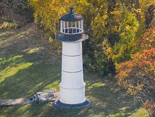
1846 (station established 1826). Inactive since 1954. 25 ft (7.5 m) round cast iron tower with lantern and gallery. Tower painted white, lantern black. The original keeper's house burned in 1962. Wood fog bell house preserved. A 20119 drione view is at right, Anderson has a fine page for the lighthouse, a 2008 photo and a 2022 closeup are available, a street view from inside the lantern is available, the Coast Guard has a historic photo of the light station, and the lighthouse is seen in a Google satellite view. The oldest of the ten surviving Lake Champlain lighthouses, this is also the oldest surviving cast iron lighthouse in the U.S. The present owners completed rebuilding the 2-story brick keeper's house in summer 2003, and by 2010 they had restored and repainted the light tower; Lynn and Tony Querrey have a photo (almost halfway down the page). This lighthouse won't be reactivated, however, because trees nearby have grown tall enough to block its light. Located on Juniper Island, about 5 mi (8 km) west southwest of Burlington. Site and tower closed. Owner/site manager: private. ARLHS USA-410.
Juniper Island (4?)
2003 (station established 1826). Active; focal plane 125 ft (38 m); white flash every 4 s. Approx. 40 ft (12 m) square cylindrical skeletal tower. Anderson has a photo, Jim Millard has a view from the lake, and Google has a satellite view. Located a short distance southwest of the historic lighthouse. Site and tower closed. Owner/site manager: private. USCG 1-39710.
Burlington Breakwater South (1) (replica)
2003 (replica of 1857 lighthouse). Active. 26 ft (8 m) square pyramidal wood tower with a small square lantern. Lighthouse painted white. Anderson's page has additional photos, John Krantz has a 2023 photo, Lighthouse Digest has a photo by Shirin Pagels, Jim Millard has a photo, and Google has a satellite view. Like the north light, this tower was completed in September 2003. Lighthouse Digest has D'Entremont's story on the reconstruction. The original tower was destroyed by a storm in 1876 and replaced by a larger tower; the Coast Guard has a historic photo of the second light. Located on the breakwater near Perkins Pier, Accessible only by boat (the breakwater does not connect to the shore). Site open, tower closed. Owner/site manager: City of Burlington. ARLHS USA-1106; USCG 1-39680.

Juniper Island Light, Lake Champlain, October 20019
Wikimedia Creative Commons photo
by Greezens
Burlington Breakwater North (2) (replica)
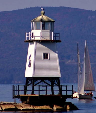
2003 (replica of 1890 lighthouse; station established 1857). Active; focal plane 35 ft (11 m); white flash every 2.5 s. 35 ft (11 m) square pyramidal wood tower with lantern and gallery. Fog horn (2 s blast every 15 s). Lighthouse painted white; lantern dome painted red. Rob Friesel's photo is at right, Anderson has a good page for the lighthouse, Lighthouse Digest has one of D'Entremont's photos of the replica, Jim Millard has a photo, another photo is available, the Coast Guard has a historic photo of the original lighthouse, and Google has a satellite view. A keeper's house, built for this station but never occupied by a keeper, was relocated to Archibald Street onshore and is used as a private residence. The lighthouse, which replaced a 35 ft (11 m) skeletal tower, was completed in September 2003. Located on a short detached breakwater north of the ferry terminal in downtown Burlington. Accessible only by boat. Site open, tower closed. Owner/site manager: City of Burlington. . ARLHS USA-1105; USCG 1-39615.
[Colchester Reef (3)]
1952 (station established 1871). Active; focal plane 51 ft (16 m); white flash every 4 s. Square skeletal tower mounted on the crib of the historic Colchester Reef lighthouse (see above). The tower carries diamond-shaped daymarks painted in a green and white checkerboard pattern. An automatic weather station was added in 1996. Anderson has a photo and Google has a satellite view. Also, the Coast Guard has a historic photo of the original light station, which was relocated in 1952 to the Shelburne Museum south of Burlington (see above). Located about 1500 yards (1370 m) off Colchester Point, north of Burlington; should be visible easily from shore. Owner/site manager: U.S. Coast Guard. ARLHS USA-182H; USCG 1-39540.

Burlington Breakwater North Light, October 2006
Flickr Creative Commons photo
by Rob Friesel

Grande Isle County (Northern Lake Champlain) Lighthouses
Isle La Motte (1)
1829 (inactive since 1856). 2-story stone house. A light was displayed from a second story window until a stone beacon was built in 1856. Site closed. Owner/site manager: private.
Isle La Motte (3)
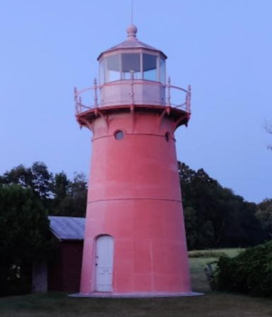
1881 (station established 1829). Reactivated (inactive 1933-2002); focal plane 46 ft (14 m); white flash every 4 s. 25 ft (7.5 m) round cast iron tower with lantern and gallery; 300 mm lens. Painted red years ago, the tower has faded to a faint rose color; the lantern is now painted white. Fog bell (inactive). A sibling of Ten Pound Island Light in Massachusetts. The original 1-1/2 story wood keeper's house is now a private residence. A 2021 photo is at right, Anderson has an excellent page with good photos, Marinas.com has aerial photos, and Google has a satellite view. The light was moved to a nearby skeletal tower in 1933, but the Coast Guard returned the light to the lighthouse on 12 October 2002. Located off Shrine Road at the northern end of Isle La Motte; access is by an unmarked private road. The island is connected to the Vermont shore of the lake by a bridge off VT 129. Site and tower closed. Owner/site manager: private. ARLHS USA-405; USCG 1-39165.
Isle La Motte (4)
1933. Inactive since 2002. Approx. 40 ft (12 m) square skeletal tower with an enclosed equipment shelter in the base. Tower painted black, equipment shelter white. Anderson has a photo and Google has a satellite view. In March 2014 the Coast Guard announced it would remove the skeletal tower unless someone wants to take ownership of it. Erik Nyfenger found that the tower was still standing as of August 2019 and a 2021 photo is available. Located adjacent to the historic lighthouse. Site and tower closed. Owner: U.S. Coast Guard. Site manager: private.
Windmill Point
1858. Reactivated (inactive 1931-2002); focal plane 52 ft (16 m); white flash every 4 s. 40 ft (12 m) octagonal limestone tower with lantern and gallery, attached by a passageway to a 1-1/2 story granite keeper's house; 300 mm lens. Originally red, the lantern has faded to orange. Jimmy Emerson's photo is at the top of this page, Anderson's page also has nice photos, Maksim Mercuri has a 2023 photo, Chris Wehner has a winter 2018 photo, Huelse has a historic postcard view, the National Archives has a historic photo, and Google has a satellite view. The lighthouse, a sibling of the Point aux Roches Light in New York marks the northern end of the the lake and the entrance to the Richelieu River. The light was moved to a skeletal tower in 1931, but with the cooperation of the owner the Coast Guard returned the light to the lighthouse on 7 August 2002. The light station is a private residence. Located at the end of Windmill Point Road, off US 2, opposite Rouses Point, New York. Site and tower closed. Owner/site manager: private. ARLHS USA-895; USCG 1-39130.

Isle La Motte Light, Isle La Motte, July 2021
Google Maps photo by Jeffrey R
#Windmill Point (2)
1931. Inactive since 2002 and largely demolished in 2013. Approx. 60 ft (18 m) square skeletal tower with an enclosed equipment shelter in the base. Tower painted black, equipment shelter white. Anderson has a photo and Google has a satellite view. In November 2013 a contractor for the Coast Guard demolished most of the tower; property owner Rob Clark salvaged the base and mounted the upper portion on it to create a miniature version of the original. Located adjacent to the historic lighthouse. Site and tower closed. Owner/site manager: private.

Lake Memphremagog Lighthouses
Lake Memphremagog is a large glacial lake on the U.S.-Canada border. The lake is 31 mi (50 km) long, but only 27% of its surface is in Vermont; the rest is in the Canadian province of Québec. Newport, at the southern end of the lake, is the largest Vrmont town on the lake.

* Whipple Point (replica)
2011 replica of 1879 lighthouse. Possibly active; light charcateristics unknown. Approx. 6 m (20 ft) hexagonal wood tower with lantern painted white with red trim. Google has a street view and a satellite view. The original lighthouse was built on a pier off the west side of the lake north of Newport. Forand has a postcard view of the original lighthouse and another historic photo that shows that lighthouse collapsing into the lake in 1906. The replica was built by Bill and Nancy Cook to serve as the ticket booth for tours of the lake on an excursion boat, but apparently this business did not succeed. We need information on the current status of the lighthouse. Located off US 5 (Main Street) on the waterfront in downtown Newport. Site open, tower closed. Owner/site manager: City of Newport.
[Whipple Point (3?)]
Date unknown. Active; focal plane 25 ft (7.5 m); white flash every 4 s. 25 ft (7.5 m) skeletal tower. No photo available but Google has an indistinct satellite view. This is the only USCG-maintained fixed light on the lake. Located about 1/4 mi (400 m) off Whipple Point on the southwest side of the lake, marking the entrance to the narrow extension of the lake leading to Newport. Accessible only by boat. Site open, tower closed. Original: ARLHS USA-425. Modern light: USCG 1-40100.

Information available on lost lighthouses:

Notable faux lighthouses:

Adjoining pages: North: Southwestern Québec | West: Central and Northern New York

Return to the Lighthouse Directory index | Ratings key

Posted 2001. Checked and revised January 31, 2024. Lighthouses: 12. Site copyright 2024 Russ Rowlett and the University of North Carolina at Chapel Hill.