title graphic

4000. UTILIZATION OF PLOTS

  1. IDENTIFICATION.

    During the complicated maneuvers of a night engagement when ships of opposing forces are rapidly changing station relative to each other, and at times even mingling with each other, it becomes impossible for the operators of radar sets to keep track of the varied pips on scopes or to tell friend from foe.

    IFF is a primary means of doing this but has not as yet been developed very extensively for surface use. The air search radar with the BL was not designed for the identification of surface units. Further, IFF is subject to battle casualty and material failure. Too, the day may come when the enemy uses IFF deceptively. Methods other than IFF alone are needed to keep contacts identified. Proof of this is the fact that combatant units of our Navy in the confusion of action have unwittingly fired upon their own units.

    The use of plots for identification has been evolved as an additional primary means of continuous identification. By keeping track of all units on a plot from the beginning of an engagement when opposing forces are distinctly separated and distinguishable, it is possible to maintain the location of all friendly units relative to hostile units during the tactical maneuvering and melee of battle. Identification can be accomplished on any of the basic types of plots, Summary, Surface, Air or Geographic. A ship prepared with such a display will not fire on its own forces.

  1. OTHER USES OF PLOTS.

    Under ordinary cruising conditions, a plot of surface vessels in company is required. It may be kept on a Geographic Plot or a Summary Plot, but is more commonly kept on a Surface Plot. By establishing each ship's station on the plot, early detection of radical movement may be made. The actions of a destroyer sheering from the screen to pursue a sonar contact are quickly known to other units, allowing them to take appropriate action. Ships on collision courses are readily apparent and are notified over TBS.

    Before broadcasting surface contacts picked up by own ship's radars, to other ships over warning net, we must convert the bearings and ranges from us to bearings and ranges from fleet center. This conversion, as well as the conversion of information reported to us over warning net, is made on the summary dot. In emergencies, as in the case of a close-in surfacing submarine or a sonar contact, the detecting ship will probably report the bearing and range from herself over the warning net. To find the position of this, emergency contact from our ship, it must be plotted from the reporting ship. Similarly when own ship picks up a possible target, its position from one of the ships in the screen may be quickly determined and the information sent to that ship so that she may investigate. Plots must be used to prevent own ship firing on own ships or planes. Either a Summary Plot or a Surface Plot can be used to reveal any ship of own force that unknowingly, in the confusion of an action, maneuvers into the line of fire between your own ship and the target. In the event of a night air attack, a Summary Plot will show whether or not a sector is clear of ships for secondary battery fire.
--63--


  1. TYPES OF PLOTS.

    New equipment being developed such as the projection PPI gives promise of providing a method for keeping a Summary, Surface or Air Plot in a manner different and superior to any now used. However, at this time polar plots are kept on several different types of boards. One of the simplest physical setups is a plastic polar plot, on which the plotting is done with china-marking pencils, in colors. This kind of plot varies from 20 inches to 48 inches in diameter, depending upon the problem to be handled and the space available. Another form of Polar Plot found satisfactory in service is a polar plot painted on heavy gauge sheet metal, using small ALNICO (aluminum-nickel-cobalt alloy) magnetic buttons to mark positions. The above plots may be mounted horizontally, vertically, or at any intermediate angle as convenient. There is another form of Polar Plot generally used as a Summary Plot that employs a thick sheet of transparent plastic, about 5 feet in diameter, mounted vertically, on which are etched the necessary bearing lines and range circles. The advantage of this type is that the personnel, by keeping the plot on the back of the plastic sheet, leave the front-of the display available for filtering and evaluation. To date this type has been used primarily aboard carriers.

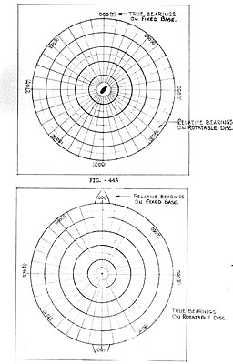
    Most Polar Plots are kept on a stationary surface, with own ship's course projector, but some are so constructed that the polar plot can be rotated manually on a fixed base. With this arrangement, either the calibrations on the rotary plot (See Figure 44A) or the calibrations on the fixed base (See Figure 4413) may be considered relative bearings. In the former case the rotary disc must be turned in the same direction and the same number of degrees as is the ship's head. This arrangement has the advantage of carrying a small task force, steaming in circle disposition with base course always the same as fleet axis, through base course changes without any need to reposition the units on the plot. Limiting arcs of train of own batteries, in this case, may be painted on the rotary part of the plot. In the case where calibrations on the fixed base are considered as relative bearings, the rotary disc must be turned in the opposite direction and the same number of degrees as is the ship's head. The advantage of this plot is that a formation steaming on a zig-zag need not be rearranged each time course is changed in the zig-zag plan. Limiting arcs of train of own batteries may be painted on the non-rotating base of the plot. Either of the above methods of keeping the plot may be speeded up by providing drive for the rotary part, through follow-up motors, directly from own ship's gyro.

  1. INFORMATION TO BE PLOTTED.

    For identification of surface vessels all friendly and enemy vessels must be shown on the plot. TBS calls must be shown alongside all friendly plots, with hull numbers alongside those friendlies that might be reported by such numbers by lookouts. It must also show the designation and composition of all raids, and the position of "fleet center." Where applicable, limiting arcs of train of own batteries should be indicated.

  1. SOURCES OF INFORMATION

    The sources from which information may be obtained for the plots are of interest, for the origin of any particular plotted position must be indicated directly on the plot. The paramount source of information for plots is own ship's search radars. Own ship's lookouts will furnish considerable

--64--


Figure 44
Figure 44A and 44B

--65--


    information, and under some conditions an appreciable amount will crime in by radio (other ships, shore installations, planes).

  1. KEEPING THE PLOT FOR IDENTIFICATION.

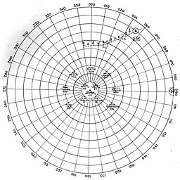
    The present position of all friendlies should be indicated by an "o", and the close in scale of the plot must be large enough to present own disposition with sufficient discrimination. The present position of each raid should be indicated by an "X", and enough of the past track should be left on the plot at all times to clearly indicate the direction of relative movement of the raid. The raid designation and composition must also be shown along each raid track. The source of each position report must be clearly indicated either by allotting certain colors to "lookout", "own radar," and "radio," or by writing small sub-scripts next to the position's symbol (XL for lookout, XR for radio, and X with no sub-script for own radar; or oL, oR, and o for friendlies). In the case of Summary Plots showing both air and surface targets, the various colors are best reserved to differentiate between air and surface contacts, leaving only sub-scripts to indicate source of reports.

--66--


Figure 45
Figure 45

--67--

Table of Contents
Previous Part (3) Next Part (5)


Transcribed and formatted by Larry Jewell & Patrick Clancey, HyperWar Foundation