Lighthouses of Spain: Western Andalusia

The Kingdom of Spain occupies nearly 85% of the Iberian Peninsula in southeastern Europe with coastlines facing south and southeast on the Mediterranean Sea and southwest and northwest on the Atlantic Ocean. Spain also includes the Balearic Islands in the Mediterranean, the Canary Islands in the Atlantic, and the cities of Ceuta and Melilla on the north coast of Morocco.

Since 1978 Spain has been divided into 17 regions called autonomous communities (comunidads autónoma) that have been granted varying degrees of autonomy by the central government. The autonomous communities are subdivided into provinces (provincias). The autonomous community of Andalucía (Andalusia in English) is in the southern part of the country, including the coastal provinces of Almería, Granada, Málaga, Cádiz, and Huelva. The western third of the coast faces southwest on the Atlantic, west of Gibraltar, while the eastern two thirds faces southeast on the Mediterranean. This page includes lighthouses of the Atlantic coast, often called the Costa de la Luz (Coast of Light), in the provinces of Cádiz and Huelva. Lighthouses of the Mediterranean coast are on the Eastern Andalusia page.

The word for a lighthouse is faro in Spanish, but its use is generally restricted to the larger coastal light stations. Smaller lighthouses are called balizas (beacons). In Spanish isla is an island, cabo is a cape, punta is a promontory or point of land, péñon is a rock, arrecife is a reef, bahía is a bay, ría is an estuary or inlet, estrecho is a strait, río is a river, and puerto is a port or harbor.

The navigational lights in Spain are the responsibility of the national port authority, Puertos del Estado, but many of them are operated and maintained by regional port authorities. The Comisión de Faros, founded in 1842 to build and maintain Spanish lighthouses, is now an advisory panel.

ARLHS numbers are from the ARLHS World List of Lights. ES numbers are from the Spanish national list of lights, Libro de Faros. Admiralty numbers are from volume D of the Admiralty List of Lights & Fog Signals. U.S. NGA List numbers are from Publication 113.

General Sources
Libro de Faros y Señales de Niebla
Online edition of the official Spanish light list.
Asociación de Amigos de los Faros de Andalucía
This support group for Andalusian lighthouses has an interesting blog with many photos.
Online List of Lights - Atlantic Spain
Photos by various photographers posted by Alexander Trabas. Many of the photos for this coast are by Eckhard Meyer.
Spain Lighthouses
Excellent aerial photos posted by Marinas.com.
Leuchttürme.net - Andalucia
Photos posted by Malte Werning.
Lighthouses in Andalusia
Photos by various photographers available from Wikimedia.
World of Lighthouses - Spain
Photos by various photographers available from Lightphotos.net.
Phares d'Europe
Photos posted by Alain Guyomard and Robert Carceller.
Navigation and Ships - Lighthouses
Photos by Fran García.
Leuchttürme Spaniens auf historischen Postkarten
Historic postcard images posted by Klaus Huelse.
GPSNauticalCharts
Navigational chart information for Andalusia.
Navionics Charts
Navigational chart for Spain's Atlantic coast.
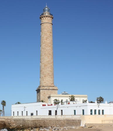

Chipiona Light, Chipiona, January 2023
Google Maps photo
by Igor Fabjan
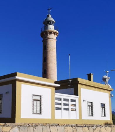
Lighthouses of Cádiz

Campo de Gibraltar (Algeciras and Tarifa) Lighthouses
The famous Strait of Gibraltar separates Europe from Africa and Spain from Morocco. On the European side the strait extends from Cape Trafalgar to Europa Point at the foot of the Rock of Gibraltar. The minimum width of the strait is 14.24 km (8.85 mi). The peninsula of Gibraltar is a British overseas territory, long claimed by Spain; there's a separate page for its lighthouses. Between Gibraltar and Barbate all the lighthouses are operated and maintained by the Port of Algeciras (Autoridad Portuaria de la Bahía de Algeciras).
Isla Verde
1864. Inactive since the 1980s. 9 m (30 ft) octagonal cylindrical stone tower, formerly attached to a 1-story keeper's house but now standing alone. Antonio Fernandez Ruz has a 2016 closeup photo, Francisco Montero Diaz has a photo, another closeup of the light tower is available, and Google has a satellite view. Endangered: Juan Yborra Golpe's 2021 closeup and Google's 2022 street view show the light tower much in need of restoration. The lighthouse was built on an island but the island has disappeared within an extensive area of fill extending the Algeciras waterfront. Located on the Calle Gaitan Ayala in the commercial port area of Algeciras. Site and tower closed; the available photos were all taken from a distance. ex-Admiralty D2422.
* Punta Carnero (Bahía de Algeciras)
1874 (Jaime Font). Active; focal plane 42 m (138 ft); four flashes every 20 s, white or red depending on direction. 19 m (62 ft) round cut stone tower with lantern and gallery, attached to a 1-story keeper's house. Tower is unpainted, lantern gray metallic. Fog siren (Morse code "K": long-short-long, every 30 s). Victorino Doncel Moreno's 2023 photo is at right, Wikimedia has Manželé Ebrovi's photo, Trabas has Capt. Peter Mosselberger's closeup, a 2021 photo is available, and Google has a street view and a satellite view. The semicircular Bahía de Algeciras (also called the Bay of Gibraltar) lies to the west of the Rock of Gibraltar; this lighthouse stands at the western entrance to the bay, directly opposite the Rock. The lighthouse is similar to the Faro de Chipiona (photo at the top of this page), also designed by Jaime Font. Located on Punta Carnero, about 10 km (6 mi) south of Algeciras on provincial highway CA-223. Site open, tower closed. . ARLHS SPA-203; ES-20110; Admiralty D2420; NGA 4128.
Tarifa
Late 1700s (partially rebuilt in 1854). Active; focal plane 41 m (135 ft); three flashes every 10 s, white or red depending on direction. 33 m (108 ft) round cut stone tower with lantern and gallery; entire lighthouse painted white. Fog siren (three 5s blasts every 60 s). The keeper's house has been renovated as a museum. Trabas has a closeup photo by Rainer Arndt, Raymond Gerard has a 2024 photo, Antonio Guerra has another good photo, Huelse has a historic postcard view, and Bing has a satellite view. This is Spain's southernmost lighthouse (excluding the lights of Spanish Morocco and the Canary Islands). It was raised in height in 1854, but the amount is unknown. Tarifa is at the western end of the narrow portion of the Strait of Gibraltar, about 25 km (15 mi) southwest of the Rock and only 14 km (9 mi) northeast of the Moroccan coastline. The lighthouse was restored in a €725,000 project in 2020-22. The lighthouse is on a small island just offshore from the town of Tarifa. The island is connected to the mainland by a causeway. Site normally closed (a gate blocks access to the island) but open to guided tours; tower closed. There are excellent views from shore. . ARLHS SPA-148; ES-20080; Admiralty D2414; NGA 4116.

Punta Carnero Light, Algeciras, Jnauary 2023
Google Maps photo by Victorino Doncel Moreno
#Punta Paloma (1)
1894. Inactive, apparently since 2004, and demolished in 2007. 2-story octagonal masonry tower incorporated as part of a keeper's house; the light was shown through a square second-story window. The house was in very poor condition, having been unoccupied since the light was automated in 1973. The light was moved to a 5 m (17 ft) square white concrete post with gallery. Located on a promontory at the end of provincial road CA-222, about 10 km (6 mi) west of La Peña. Site appears open. ARLHS SPA-248.
Punta Paloma (3)
2020. Active; focal plane 50 m (164 ft); focal plane 45 m (148 ft); white or red light, depending on direction, occulting once every 5 s. Approx. 9 m (30 ft) white octagonal tower. The tower, designed by the architect Manuel Matoses, has sides that are rotated by 10° between the base and the roof. A good photo is available, Trabas has Meyer's closeup, a 2023 photo is available, and Google has a satellite view. Located on the site of the original lighthouse. Site appears open, tower closed. ES-20070; Admiralty D2412; NGA 4112.
* Camarinal (Cabo de Gracia)
1989. Active; focal plane 75 m (246 ft); white light occulting twice every 5 s. 20 m (66 ft) round stone watchtower converted into a lighthouse by adding a lantern mounted on 8 posts on the roof. The unpainted tower is a 16th century watchtower built of cut, fitted stone. Access is through a door midway in the tower, reached by a stairway that spirals up a post next to the tower. Luis Galiana Jaraba's closeup 2022 photo is at right, Trabas has an excellent closeup photo by Meyer, Wikimedia has a good 2008 photo, Alfonso Lopez Saez has a street view, and Google has a satellite view. Located on a high promontory near Camarinal, halfway between Barbate and Tarifa. Accessible by road; limited parking provided. Site open, tower closed. . ARLHS SPA-336; ES-20065; Admiralty D2411.5; NGA 4110.

Barbate Lighthouses
These lighthouses are operated by the Port of Cadiz Bay (Autoridad Portuaria de la Bahía de Cádiz).

*
Barbate
1862 (Eduardo Saavedra). Active; focal plane 22 m (72 ft); two flashes every 7 s, white or red depending on direction. 18 m (59 ft) round cylindrical concrete tower supporting an octagonal equipment room with the light mounted on the roof. Lighthouse painted white with red horizontal bands. Trabas has Meyer's closeup, Wikimedia has a good photo, Juan Miguel Rodríguez Caballero has a closeup 2020 photo, and Google has a street view and a satellite view. The lighthouse was "restored" in 1929, and the upper section may have been added at that time. Note: Spanish Wikipedia calls this light a baliza rather than a faro. Located just off the waterfront in Barbate, a small port and beach resort about 8 km (5 mi) east of Cabo Trafalgar. Site open, tower closed. . ARLHS SPA-071; ES-20022; Admiralty D2408; NGA 4084.
 

Camarinal Light, Camarinal, July 2022
Google Maps photo by Luis Galiana Jaraba
 
* Cabo Trafalgar
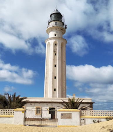
1862. Active; focal plane 51 m (167 ft); three white flashes in a 2+1 pattern every 15 s. 34 m (112 ft) round 8-ribbed tower with lantern and gallery, attached to a 1-story keeper's house. Entire lighthouse painted white. is at right, Teresa González has the 2021 photo seen at right, Trabas has a closeup photo, Francesco Maestri has a 2022 photo, Mike Beaton has a good photo, Manuel Fernández has a street view, and Google has a satellite view. The eight ribs were added to the lighthouse in 1926 to strengthen it to support a larger lantern structure. In 2024 controversy arose over a proposal to add an information center and restaurant to the lighthouse. Trafalgar, located at the northwestern entrance to the Strait of Gibraltar, is famous as the location of Britain's decisive naval victory over France and Spain on 21 October 1805. The lighthouse is on the point of the cape, about 3 km (1.8 mi) south of Zahora this is about 1 km (0.6 mi) from the end of the paved road, so a long walk on the beach is needed. Site open, tower closed. ARLHS SPA-052; ES-20010(=10690); Admiralty D2406; NGA 4080.

Conil de la Frontera Lighthouse
* Cabo Roche
1986. Active; focal plane 45 m (148 ft); four white flashes every 24 s. 20 m (66 ft) square cylindrical stone watchtower, mounted on a pyramidal base, with lantern and gallery rising from the roof on four concrete pillars. Lighthouse painted a very light yellow; lantern is unpainted gray metallic. Trabas has a fine closeup, Glyn Lewis has a 2024 photo of the light in action, and Google has a street view and a satellite view. This lighthouse is a recent lighting of a late 16th century watchtower. Located at the point of the cape about 2.5 km (1.5 mi) south of the town of Cabo Roche. Accessible by road; limited parking provided. Site open, tower closed. . ARLHS SPA-041; ES-10655; Admiralty D2405; NGA 4077.

Chiclana de la Frontera Lighthouses
Sancti Petri
1918. Active; focal plane 20 m (66 ft); white flash every 3 s. 16 m (52 ft) square cylindrical stone watchtower, mounted on a pyramidal base, with lantern on the roof. Tower unpainted; lantern painted white. Trabas has a photo, Diego Sanchez has a 2022 photo, amateur radio operator WC6DX has posted a closeup photo, Bernd Bragado has a street view, and Google has a satellite view. The Isla de Sancti Petri lies about 1.5 km (1 mi) off the coast at the mouth of the Río Iro. The lighthouse is built on the north side of a circular fortification dating from around 1610. Located about 20 km (13 mi) south southwest of Cádiz. Accessible only by boat. Site and tower closed. ARLHS SPA-065; ES-10630; Admiralty D2388; NGA 4060.

Cabo Trafalgar Light, Barbate, October 2021
Google Maps photo by Teresa González

Cádiz City Lighthouses
The Bahía de Cádiz is a large, partly sheltered harbor facing west on the open Atlantic; it has been an important Spanish port for centuries. These lighthouses are operated by the Port of Cadiz Bay (Autoridad Portuaria de la Bahía de Cádiz).
* Castillo de San Sebastián (Cádiz) (2)
1855 (station established about 1776). Approx. 7.5 m (25 ft) round stone tower, the remnant of what was originally a 39 m (128 ft) stone tower. Google has a closeup photo and a satellite view. In 1898 the military commander of Cádiz ordered the lighthouse demolished for fear it would guide attacking U.S. ships during the Spanish-American War (in fact the U.S. made no attacks on the Spanish mainland). Located near the present lighthouse.
* Castillo de San Sebastián (Cádiz) (3)
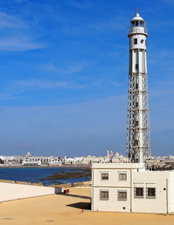
1913 (station established about 1776). Active; focal plane 39 m (128 ft); two white flashes every 10 s. 37 m (121 ft) octagonal skeletal tower with central cylinder, lantern, and gallery. Entire structure painted white. Fog horn (one long and one short blast every 20 s). Pepe Rodríguez Cordon's 2012 photo is at right, Trabas has a photo by Mayer, Manuel Dueñas has a 2009 photo, Paul Nechkova-Raven has a 2014 photo, Huelse has a historic postcard image, and Google has a street view and a satellite view. The only surviving lighthouse of this type in Spain, it serves as the landfall light for Cádiz.The port authority restored and repainted the lighthouse in 2017. The Castillo de San Sebastián was built, starting in the early 17th century, on a small island commanding the approach to Cádiz; the island had earlier been the location of a monastery dedicated to San Sebastián. The island has been joined to the mainland by a jetty since the late 1800s; access to the fortress and lighthouse is by walking the pier, about 2 km (1.25 mi) round trip. On-sreet parking is available is available at the base of the pier but may be crowded. Site open, tower closed. . ARLHS SPA-063; ES-10250; Admiralty D2362; NGA 3940.
Cádiz Approach Range Rear
Date unknown. Active; focal plane 21 m (69 ft); green light occulting once every 3 s. 21 m (69 ft) round cylindrical tower mounted on a round concrete pier supported by a massive pile. Trabas has a photo but the light is not shown in Bing's satellite view. The front light is on a similar but much shorter tower. Located in the center of the Bahía de Cádiz, about 3.5 km (2.2 mi) northeast of the waterfront. Accessible only by boat. Site open, tower closed. ES-10267.1; Admiralty D2380.1; NGA 3950.1.

El Puerto de Santa María Lighthouse
El Puerto de Santa María, known locally as El Puerto, is a modern port on the Río Guadalete opposite Cádiz. Lighthouses of El Puerto and those of Rota are operated by the Autoridad Portuaria de la Bahía de Cádiz.

*
Puerto Sherry
Date unknown. Active; focal plane approx. 23 m (75 ft); red light occulting once every 4 s. Approx. 23 m (75 ft) stucco-clad harbor control tower with lantern and gallery, painted a very light yellow. Juan Carlos Rodriguez Arias has a 2021 photo, Trabas has a closeup by Meyer, Wikimedia has a 2010 photo by Jose Tomas Tocino, Alexey Knizhnikov has a 2022 photo, and Google has a distant street view and a satellite view. Located at the end of the breakwater sheltering Puerto Sherry, a large yacht basin just west of the mouth of the Río Guadalete in El Puerto de Santa María. Accessible by a short walk on the pier; parking available. Site open, tower closed. Site manager: Puerto Sherry. . ARLHS SPA-338; ES-10185; Admiralty D2382; NGA 4037.

Castillo de San Sebastián Light, Cádiz, Sepetmber 2012
Flickr Creative Commons photo by Pepe Rodríguez Cordon

Rota Lighthouses
Rota Naval Base Range Rear
Date unknown. Active; focal plane 27 m (92 ft); white light occulting once every 3 s. 15 m (49 ft) square pyramidal skeletal tower, painted white. Trabas has Meyer's photo and Google has a satellite view. The front light is on a similar but shorter tower. Rota, at the northern entrance to the Bahía de Cádiz, is aa resort town and also a major base for the Spanish and U.S. Navies. Located on the base, near the harbor. Site and tower closed (military reservation). ES-10161; Admiralty D2359.1; NGA 3924.
* Rota (1)
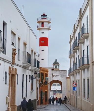
1909 (Francisco García de Sola). Inactive since 1980. Lantern mounted atop an archway over the Calle Gravina at the front of the port. Humberto Vila's 2024 photo is at right, Manuel Caballero has a similar 2010 photo, Barinia Alonso has a 2023 photo, Trabas has a photo by Hans-Albert Liebetrau, and Google has a street view. Site open, tower closed.
* Rota (2)
1980 (station established 1909). Active; focal plane 34 m (112 ft); 28 m (92 ft) round cylindrical concrete tower with lantern and double gallery. Lighthouse painted white with a single red band; lantern dome is unpainted metallic gray. Humberto Vila's 2024 photo is at right, Manuel Caballero has a similar 2010 photo, Antonio Garcia Prats has a 2024 photo, Trabas has a photo by Hans-Albert Liebetrau, Rosa María Gordo has a 2023 photo, and Google has a street view and a satellite view. The lighthouse is located on the waterfront of the civilian port, at the end of the Avenida de San Juan de Puerto Rico. Site open, tower closed. . ARLHS SPA-085; ES-10140; Admiralty D2355.2; NGA 3908.

Chipiona Lighthouse
This lighthouse and the lighthouses of Sanlúcar de Barrameda are located at the mouth of the Río Guadalquivir, on the western border of Cádiz province. The river leads to the major port of Sevilla (Seville) and the lighthouses are operated by the Port of Seville (Autoridad Portuaria de Sevilla)

**
Chipiona (Punta del Perro)
1867 (Jaime Font). Active; focal plane 69 m (226 ft); white flash every 10 s. 63 m (207 ft) round cut stone tower with lantern and gallery, mounted on a 4-story square stone base and rising from the front of a 2-story keeper's house. The lighthouse is unpainted; keeper's house painted white. Igor Fabjan's 2023 photo is at the top of this page, Chris Applegate has a photo, Trabas has a closeup, Carlos Rodriguez Arias has a 2021 photo, Marinas.com also has aerial photos. Huelse has a historic postcard view, and Google has a street view and a satellite view. This lighthouse, the tallest in Spain, serves as the landfall light for Seville. Located on the Punta del Perro in Chipiona, about 6 km (4 mi) southwest of the Río Guadalquivir entrance. Site open, tower generally closed; tours are available by prior arrangement with the local tourism office. . ARLHS SPA-301; ES-09180; Admiralty D2351; NGA 3880.


Rota Lights (old and new), Rota, March 2024
Google Maps photo by Humverto Vila

Bajo Salmedina
Date unknown. Active; focal plane 9 m (30 ft); nine quick white flashes every 15 s. 10 m (33 ft) round concrete tower painted yellow with one black horizontal band. Trabas has Meyer's photo and Google has a satellite view. Located at the end of a shoal extending from the Punta del Perro, about 5 km (3 mi) west northwest of the Chipiona lighthouse. Accessible only by boat. Site open, tower closed. ES-10080; Admiralty D2350.4; NGA 3882.

Sanlúcar de Barrameda Lighthouses
* Bonanza (New Canal) Range Front (3)]
Date unknown. Active; focal plane 29 m (95 ft); quick-flashing white light. 22 m (72 ft) (?) square cylindrical skeletal tower, painted white. The tower carries a square daymark panel painted yellow. Google has a street view and an indistinct satellite view. Trabas has Meyer's photo. This is the entrance range for the Río Guadalquiver. Located on the Avenida de Huelva on the south side of Bonanza. Site open, tower closed. ES-09220; Admiralty D2348.5; NGA 3864.
* Bonanza (New Canal) Range Rear (3)
2012. Active; focal plane 62 m (203 ft); white light, 2 s on, 2 s off. 30 m (98 ft) square cylindrical skeletal tower with gallery, painted white. The tower carries at the top a square slatted daymark painted yellow. Trabas has Meyer's photo and Google has a satellite view and a distant street view. Located on a hilltop off the Camino de Sevilla on the west side of Bonanza. Site open, tower closed. ES-09221; Admiralty D2348.51; NGA 3868.
* Bonanza Leading (former Range Front)
1865. Reactivated (inactive 1982-2008); focal plane 23 m (75 ft); white light, 2 s on, 2 s off, visible only to the south southeast. 20 m (66 ft) octagonal brick tower on a square base. Tower is unpainted red brick; lantern painted white. Isabel María Rodríguez's 2021 photo at right, Trabas has a good photo, Javier Gordillo has a 2011 photo, a good 2016 photo is available,, Huelse has a historic postcard view, and Google has a street view and a satellite view. From 1897 to 1982 this lighthouse was the front light of a range for ships entering the Río Guadalquivir. According to Falcón, the original inbound (northbound) range was deactivated in 1982, replaced by buoys along the channel. The reactivated light is directional and has a very different purpose; it is visible only to outbound ships approaching southbound in the channel. Located at the south end of the commercial dock area in Bonanza, on the east bank of the Guadalquivir at the first bend in the estuary about 4 km (2.4 mi) northeast of Sanlúcar de Barrameda. Site open, tower closed. . ARLHS SPA-073; ES-09400; Admiralty D2346; NGA 3877.
* San Jerónimo (Bonanza Range Rear)
1897. Inactive since 1982. 24 m (79 ft) round cylindrical brick tower with gallery; lantern removed. The tower is unpainted red brick. Sergio Tournellec has a 2022 photo, Jose Luis Ibañez has a 2021 view, and Google has a satellite view and a distant street view. Located on the Camino Colorado 800 m (1/2 mi) northeast of the Faro de Bonanza. Site open, tower closed. Site manager: unknown. ARLHS SPA-340.

Bonanza Light, Bonanza, August 2021
Instagram photo by Isabel María Rodríguez

Lighthouses of Huelva

Huelva, the westernmost province of Andalucía, faces the Atlantic next to Portugal's Algarve coastline. Lighthouses in Huelva are maintained and operated by the Autoridad Portuaria de Huelva.

Almonte Lighthouse
 
* La Higuera (Matalascañas)
1986. Active; focal plane 47 m (154 ft); three white flashes every 20 s. 24 m (79 ft) triangular cylindrical concrete tower with lantern. The tower is white concrete with a single red horizontal band near the top; lantern painted white. Trabas has Meyer's photo, Wikimedia has photos, Ana Garrido has another photo, Sergio Garcia Isidoro has a 2022 closeup, and Google has a satellite view and a distant street view. The architects of this modern lighthouse, Ismael Guarner and José Fernández, were inspired by the monolith in the film 2001. Located behind the beach at Matalascañas, about 35 km (22 mi) southeast of Mazagón. Site open, tower closed. . ARLHS SPA-174; ES-09175; Admiralty D2345; NGA 3863.

Mazagón Lighthouses
* Punta del Picacho (Mazagón)
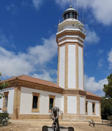
1884. Active; focal plane 52 m (171 ft); six white flashes, in a 2+4 pattern, every 30s s. 25 m (82 ft) octagonal cylindrical cut stone tower with lantern and double gallery, rising from the front of a 1-story keeper's house. 3rd order Fresnel lens (1899) in use. Lighthouse painted white with unpainted buff-colored brick trim; lantern dome is unpainted metallic gray. A 2019 photo by Antonio Castillo Lopez is at right, Wikimedia has a collection of Marc Ryckaert's photos, Trabas has a great photo, a 2016 photo is available, Javier Farias has a 2022 photo, and Google has a street view and a satellite view. This historic light station is the traditional landfall light for the port of Huelva. Located on the Avenida del Mar in Mazagón, on the east side of the entrance to the Río Odiel. Site open, tower closed. . ARLHS SPA-185; ES-08700; Admiralty D2320; NGA 3844.
* Padre Santo (Río Odiel Leading Light)
Date unknown. Active; focal plane 61 m (200 ft); white, red or green light depending on direction (a continuous white light is shown on the proper line of approach; occulting, continuous, or flashing red or green lights are shown to the sides). 15 m (49 ft) round cylindrical dumbbell-shaped tower, painted white. Trabas has a closeup photo and Google has a street view and a satellite view. This is the approach range for the Río Odiel. According to Findlay's 1879 list, a pair of range lights were established near here in 1861. Located on a bluff off the end of the Calle de los Reyes Católicos on the west side of Mazagón. Site open, tower closed. ARLHS SPA-095; ES-08722; Admiralty D2324.05; NGA 3845.

Mazagón Light, Mazagón, July 2019
Google Maps photo by Antonio Castillo Lopez
* Río Odiel (Dique Juan Carlos I)
1983. Active; focal plane 31 m (102 ft); four white flashes, in a 3+1 pattern, every 20 s. 26 m (89 ft) round cylindrical concrete tower with lantern and double gallery. Lighthouse painted white with a single red band below the galleries; lantern dome is unpainted metallic gray. Trabas has a photo by Capt. Peter Mosselberger, Samuel Zarza Diaz has a 2023 photo, and Google has a street view and a satellite view. The lighthouse marks the entrance to the Río Odiel and the port of Huelva. The west breakwater, now called the Dique Juan Carlos I, curves southeastward for several miles, extending the natural sandspit of Punta Umbría. The road along the spit and breakwater is apparently open to the public. Site open, tower closed. ARLHS SPA-099; ES-08710; Admiralty D2321; NGA 3861.

Cartaya Lighthouses
* El Rompido (1)
1861. Inactive since 1976. Approx. 10 m (33 ft) round stone tower with lantern and gallery, attached to a 1-story keeper's house. Lighthouse painted white; lantern dome is unpainted metallic gray. A 2022 photo is at right, García has a good photo, Miguel Lucio-V.M. has a 2021 photo of both lighthouses, Tomás Fano has a good photo of the two lighthouses, and Trabas also has a photo. The lantern appears to be in poor condition. The light station was built on the west side of the entrance to the Río Piedras and the harbor of El Rompido in Cartaya. Since 1861 the Flecha de El Rompido, the barrier sandspit that protects the lower course of the river, has extended itself 8 km (5 mi) to the east, putting the lighthouse that far to the west of the river's mouth. Located on the waterfront of El Rompido. Site open, tower closed.
* El Rompido (2)
1976 (station established 1861). Active; focal plane 43 m (141 ft); two white flashes every 10 s. 29 m (95 ft) round cylindrical concrete tower with lantern and double gallery. Lighthouse painted white with a single red band below the galleries; lantern dome is unpainted metallic gray. A 2022 photo is at right, Fran García has a good photo, Trabas also has a photo, Miguel Lucio-V.M. has a 2021 photo of both lighthouses, Tomás Fano has a good photo of the two lighthouses, Wikimedia has photos, and Google has a street view and a satellite view. The lighthouse was formerly painted with black and white horizontal bands; faded bands can be seen in some older photos. It seems odd that this lighthouse now has the same daymark as the nearby Río Odiel lighthouse. Located behind the historic lighthouse. Site open, tower closed. . ARLHS SPA-271; ES-08570; Admiralty D2312; NGA 3828.

El Rompido Lights (old and new), El Rompido, September 2022
Instagram photo by Pere Pinos

Information available on lost lighthouses:

Notable faux lighthouses:

Adjoining pages: East: Eastern Andalusia | South: Gibraltar | West: Southern Portugal

Return to the Lighthouse Directory index | Ratings key

Posted February 1, 2006. Checked and revised June 24, 2024. Lighthouses: 30. Site copyright 2024 Russ Rowlett and the University of North Carolina at Chapel Hill.