Lighthouses of Spain: Valencia and Murcia

The Kingdom of Spain occupies nearly 85% of the Iberian Peninsula in southeastern Europe with coastlines facing south and southeast on the Mediterranean Sea and northwest on the Atlantic Ocean. Spain also includes the Balearic Islands in the Mediterranean, the Canary Islands in the Atlantic, and the cities of Ceuta and Melilla on the north coast of Morocco.

Since 1978 Spain has been divided into 17 regions called autonomous communities (comunidads autónoma) that have been granted varying degrees of autonomy by the central government. The autonomous communities are subdivided into provinces (provincias). This page includes lighthouses of two of Spain's eastern regions, including the provinces of Castellón, Valencia, Alicante, and Murcia. The Región de Murcia is an autonomous community as well as a province while the remaining three provinces form another autonomous community called the Comunidad Valenciana. This coastline faces southeast on the Mediterranean, bordering Andalusia to the south and Catalonia to the north.

The word for a lighthouse is faro in Spanish but its use is generally restricted to the larger coastal light stations. Smaller lighthouses are called balizas (beacons). In Spanish isla is an island, cabo is a cape, punta is a promontory or point of land, péñon is a rock, arrecife is a reef, bahía is a bay, ría is an estuary or inlet, estrecho is a strait, río is a river, and puerto is a port or harbor. In the Valencian Community many people speak Valencian, a language closely related to Catalan. In Catalan the word for a lighthouse is far, balisa is a beacon, illa is an island, cap is a cape, punt is a promontory or point of land, roca is a rock, escull is a reef, badia is a bay, ria is an estuary or inlet, estret is a strait, riu is a river, and port is a port or harbor.

The navigational lights in Spain are the responsibility of the national port authority, Puertos del Estado, but many of them are operated and maintained by regional port authorities. The Comisión de Faros, founded in 1842 to build and maintain Spanish lighthouses, is now an advisory panel.

ARLHS numbers are from the ARLHS World List of Lights. ES numbers are from the Spanish national list of lights, Libro de Faros. Admiralty numbers are from volume E of the Admiralty List of Lights & Fog Signals. U.S. NGA List numbers are from Publication 113.

General Sources
Libro de Faros y Señales de Niebla
Online edition of the official Spanish light list.
Online List of Lights - Spain East Coast
Photos by various photographers posted by Alexander Trabas. Many of the photos for this coast are by Eckhard Meyer.
Phares d'Europe
Photos posted by Alain Guyomard and Robert Carceller.
Lighthouses, Islands and Capes
This collection of photos by José Miralles Pol has some fine photos of lighthouses in this area.
Spain Lighthouses
Fine aerial photos posted by Marinas.com.
Lighthouses in Spain
Photos by various photographers available from Wikimedia.
World of Lighthouses - Spain
Photos by various photographers available from Lightphotos.net.
Luces para la Navegacíon
Photos and accounts posted by the regional government of Murcia.
Spanische Leuchttürme auf historischen Postkarten
Historic postcard images posted by Klaus Huelse.
GPSNauticalCharts
Navigational chart information for Spain's Mediterranean coast.
Navionics Charts
Navigational chart for Spain's Mediterranean coast.


Cabo de la Nao Light, Marina Alta, May 2023
Google Maps photo by Provincia Teruel
Castellón Province Lighthouses

Lighthouses in Castellón are operated and maintained by the Autoridad Portuaria de Castellón. The coast of the province is called the Costa del Azahar (Orange Blossom Coast). The province is subdivided into eight service regions called comarcas.

Baix Maestrat Lighthouses
* Benicarló Dique del Sur
Date unknown (1930s?). Active; focal plane 8 m (26 ft); three red flashes every 9 s. 6 m (20 ft) octagonal cylindrical masonry tower with gallery, painted red. Trabas has a closeup photo and Google has a satellite view. The NGA listing for this light underestimates its size. Located at the end of the south breakwater of Benicarló. Accessible by walking the breakwater. Site open, tower closed. ES-27250; Admiralty E0239; NGA 5536.
* Peñíscola (Castillo del Papa Luna)
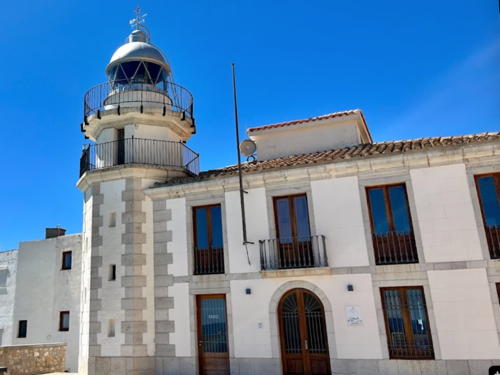
1898 (Francisco Pérez Alonso). Active; focal plane 56 m (184 ft); three white flashes, in a 2+1 pattern, every 15 s. 11 m (36 ft) round masonry tower with lantern and double gallery, attached to the front of a 2-story masonry keeper's house. 3rd order Fresnel lens in use. Lighthouse painted white; lantern is gray metallic. A 2022 photo by Helmuth Hernández is at right, Trabas has Meyer's closeup view from below the lighthouse, Wikimedia has a closeup photo, a view from above is available, and Google has a street view and a satellite view. Papa Luna (Pope Luna) was Pedro Martínez de Luna, a powerful Catholic cardinal who ruled from 1394 to 1417 as antipope Benedict XIII at Avignon, France, during the time when there were competing popes at Avignon and Rome. Excommunicated at the end of this schism in 1417, he fled to this Aragonese castle, where he lived until his death in 1423. The lighthouse stands just below the castle on a walled promontory extending from the village of Peñíscola. Site open, tower closed. . ARLHS SPA-067; ES-27150; Admiralty E0232; NGA 5520.

Peñíscola Light, Baix Maestrat, August 2022
Google Maps photo by Helmuth Hernández

Plana Alta Lighthouses
* Cabo de Irta (Alcossebre, Cala Mundina)
1990 (Rita Lorite Becarra). Active; focal plane 33 m (108 ft); four white flashes every 18 s. 28 m (92 ft) square cylindrical white concrete tower with double gallery, rising from a 1-story service building. Trabas has a good photo of this unusual lighthouse, Wikimedia also has a fine closeup, Drilloquei Drillo has a view from the sea, Jaroslaw Borowski has a street view, and Google has a satellite view. Located on the beach about 3 km (2 mi) north of Alcossebre. Site open, tower closed. ARLHS SPA-030; ES-27140; Admiralty E0231.6; NGA 5518.
* Oropesa
1857 (rebuilt in 1891). Active; focal plane 24 m (79 ft); three white flashes every 15 s. 13 m (43 ft) round masonry tower with lantern and double gallery, centered on a 2-story masonry keeper's house. Lighthouse painted white; lantern is gray metallic. Silvi Odetto's 2023 photo is at right, Trabas has a closeup photo, Theo De Waal has a 2017 closeup photo, Marinas.com has aerial photos, and Google has a street view and a satellite view. The second story was added to the house in 1891; Wikimedia has a historic photo taken before this addition. The lighthouse is dwarfed today by high-rise beach resorts. Located on a promontory at Oropesa del Mar, about 20 km (13 mi) northeast of Castellón de la Plana. Site open, tower closed. ARLHS SPA-035; ES-27100; Admiralty E0230; NGA 5516.
Islas Columbretes (Monte Colibrí) (2)
1859. Active; focal plane 85 m (279 ft); four white flashes, in a 3+1 pattern, every 22 s. 20 m (66 ft) round masonry tower with lantern and gallery, rising from the center of a 2-story masonry keeper's house. Lighthouse painted white with ocher trim; lantern is gray metallic. A closeup photo is available, Miralles Pol has a page with photos, ARLHS has a good photo, Trabas has a view from the sea by Alfonso Biescas Vignau, and Google has an indistinct satellite view. An octagonal light tower without lantern, about 6 m (20 ft) tall, stands in front of the lighthouse; this is an automated beacon, built in 1961, that serves as a backup in case the main light fails. Located about 50 km (30 mi) east of Cabo Oropesa, the Islas Columbretes are a group of four uninhabited, rocky islets with a total area of only 19 ha (47 acres). Ships have been crashing on these rocks since antiquity but today they are a popular destination for scuba divers. The lighthouse was automated in 1975 and since 1987 the keeper's house has been a residence and office for park rangers stationed on the islands. In 2008 the building was restored and renovated by the Ministerio de Medio Ambiente (Department of the Environment); provision was made for a visitor center to be developed in the future. Located atop the largest islet, Columbrete Grande. Accessible only by boat. Site open, tower closed. Site manager: Reserva Natural de las Islas Columbretes. ARLHS SPA-180; ES-26620; Admiralty E0222; NGA 5504.

Oropesa Light, Plana Alta, May 2023
Instagram photo by Silvi Odetto
Castellón Dique de Levante
Date unknown. Active; focal plane 13 m (43 ft); four green flashes every 11 s. 10 m (33 ft) round barbell-shaped metal tower painted green. Trabas has Meyer's photo and Google has a satellite view. Located at the southwest corner of the main breakwater at Castellón de la Plana. Site and tower closed. ES-26950; Admiralty E0226.1; NGA 5482.
Castellón (5)
2022 (station established 1867). Active; focal plane 32 m (105 ft); white flash every 8 s. 27 m (89 ft) round concrete tower with lantern and gallery painted white with blue trim; lantern painted blue. Trabas has Meyer's photo and Google has a satellite view. Located at the east elbow of the main quay of Castellón. Site and tower closed. ES-26940; Admiralty E0226; NGA 5480.
#Castellón (4)
1971 (station established 1867). Replaced and removed in 2022. 28 m (92 ft) slender round cylindrical concrete tower with lantern and double gallery, centered on a round 1-story keeper's house. The lighthouse was most recently painted white. Oleksii Petrovich has a 2020 street view but Google's satellite view confirms the demolition of the lighthouse. Located on the commercial quay in Castellón de la Plana. Site and tower closed. ARLHS SPA-107.
* Castellón (3)
1917 (station established 1867). Inactive since 1971. Approx. 12 m (39 ft) octagonal masonry tower with lantern and gallery, attached to a small 1-story masonry keeper's house. The lighthouse is unpainted. Andreas Köhler has the 2017 closeup photo at right, Angeles Mosquer has a good photo, Beatriz Lluch Palomares has a photo, David Garcia Fernandez has a street view, Huelse has a historic postcard view, and Google has a satellite view. The first Castellón lighthouse, a U-shaped keeper's house with lantern identical to the Burriana lighthouse (next entry), was located on the beach; it was replaced by a temporary light on the breakwater in 1910 and then by this lighthouse in 1917. Located on the commercial quay in Castellón de la Plana. Site open, tower closed. Site manager: unknown. .

Plana Baixa Lighthouses
* [Burriana (1)]
1867. Inactive since 1934. 1-story U-shaped masonry keeper's house; lantern removed. It is reported that this building was used as a girls' school but today is it occupied by a neighborhood association. Google has a street view and a satellite view. Located at the north end of the Calle de la Farola in Burriana. Site open, building status unknown. Site manager: Associacío de Veíns del Grau. ARLHS SPA-348.

1917 Castellón Light, Castellón de la Plana, May 2017
Google Maps photo by Andreas Köhler
* Burriana Dique de Levante
1934 (?). Active; focal plane 12 m (39 ft); two green flashes every 8 s. 8 m (26 ft) octagonal cylindrical masonry tower with gallery, painted green. Trabas has a closeup photo and Google has a street view and a satellite view. Located at the end of the outer (east) breakwater of Burriana. Accessible by walking the breakwater. Site open, tower closed. ES-26550; Admiralty E0219; NGA 5456.
* Burriana Dique de Poniente
Date unknown. Active; focal plane 10 m (33 ft); two red flashes every 8 s. The light is centered on the roof of a 1-story pierhouse restaurant. Trabas has Meyer's closeup photo and Google has a street view and a satellite view. Located at the end of the west breakwater of Burriana, a small port about 7 km (4.5 mi) south of Castellón de la Plana. Accessible by walking the breakwater. Site open, tower closed. Site manager: Restaurante Nautico Burriana. ES-26560; Admiralty E0221; NGA 5464.
* Nules
1992 (Blanca Lleó). Active; focal plane 38 m (125 ft); white light occulting twice every 11 s. 36 m (118 ft) square cylindrical masonry tower with an off-center lantern. The lighthouse is an unpainted light gray-brown color. A 2024 photo by Petra Evenhs is at right, Trabas has Meyer's photo, Jose Vte Bonilla Martinez has a closeup, Arturo Torralba has a 2023 photo, and Google has a street view and a satellite view. An interesting structure, though not the most attractive of modern Spanish lighthouses. Located on the beach at Playa de Nules, about 16 km (10 mi) south of Castellón. Site open, tower closed. ARLHS SPA-134; ES-26540; Admiralty E0218; NGA 5454.
 

Nules Light, Playa de Nules, February 2024
Google Maps photo by Petra Evenhs
 

Valencia Province Lighthouses

Lighthouses in Valencia are operated and maintained by the Autoridad Portuaria de Valencia. The city of Valencia is both the regional and provincial capital and the third largest city of Spain, with a population of nearly 800,000 within the city limits and a metropolitan population of at least 1.6 million. The province is subdivided historically into 17 comarcas.

Camp de Morvedre Lighthouse
* Cabo Canet
1904. Active; focal plane 33 m (108 ft); two white flashes every 10 s. 30 m (98 ft) unpainted round brick tower with lantern and gallery, mounted on an octagonal brick base. Lantern dome painted red. There are two 1-story keeper's cottages adjacent to the lighthouse. Trabas has a good photo, Wikimedia has a fine photo, Manuel Hernández Lafuente has a 2022 photo, José Miralles Pol has also posted a photo, a good closeup is available, and Google has a street view and a satellite view. The lighthouse is located at Nova Canet, about 1.5 km (1 mi) north of Sagunto and 30 km (19 mi) north of Valencia. Site open, tower closed. . ARLHS SPA-010; ES-26500; Admiralty E0216; NGA 5452.

Valencia City Lighthouses
* Cabañal (Cabanyal)
Date unknown (1850s or earlier). Inactive since 1918. Lights were shown from the towers of the Iglesia de Nuestra Señora de los Angeles. A photo of the church is available and Google has a street view and a satellite view. A light was shown from the north tower at least in the 1850s. In 1862 the church was upgraded to faro with a stronger light on the south tower. The light was downgraded to minor status in 1909, when the tall Dique del Norte lighthouse was built (see below), and it was extinguished in 1918. El Cabañal is the neighborhood of Valencia lying just north of the harbor. Located on the Camino del Cabañal at the Calle Pedro Maza, about 800 m (1/2 mi) from the beach. Site open, tower closed. ARLHS SPA-347.
* Valencia (2) (Dique del Norte)
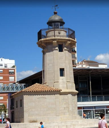
1909 (relocated in 1930) (station established 1866). Inactive since 2015. 22 m (72 ft) round cast iron tower concealed inside an octagonal masonry tower with lantern and double gallery. The lighthouse is unpainted stone; the lantern and watch room are gray metallic. Antonio Sanjoaquin's 2022 photo is at right, Alberto Muñoz Cubel has a 2011 photo, José Miralles Pol has a panoramic view, and Google has a satellite view. This lighthouse was originally a cast iron tower built on the Malecón del Norte. The pier was extended in the 1920s and renamed the Dique del Norte. The extension left the lighthouse far from the end of the pier, so it was relocated in 1930. Apparently the engineers found it to be in somewhat shaky condition and it was decided to build a masonry shell around the cast iron. Endangered: In 2022 City Council announced a plan to demolish the lighthouse, sparking strong protests from cultural organizations. As a result plans have been made to demolish and then rebuild the tower at a different location. However his project does not appear to be funded as yet. The lighthouse is located at the bend of the main breakwater of Valencia, on the north side of the harbor. The road on the breakwater may not be open to visitors' cars but it appears the lighthouse is accessible by walking a short distance. Site open, tower closed. . ARLHS SPA-138.

Dique del Norte Light, Valencia, January 2022
Google Maps photo by Antonio Sanjoaquin
Valencia (3) (Dique Exterior)
2015. Active; focal plane 35 m (115 ft); white flash every 10 s. 22 m (72 ft) hexagonal skeletal tower, made of lightweight composite materials and colored black with yellow cross-sections, standing on a hexagonal concrete base. A yellow spiral stairway in the center of the tower provides access to the light. This innovative design is by Ignacio Pascual, an architect and the infrastructure director for the port. The tower was prefabricated in Toledo and erected in less than three hours. Juan Ramón Cuesta Parres has a 2020 photo, Trabas has Hartmut Knape's photo, a 2018 photo and another photo are available, and Google has a satellite view. Located at the right-angled elbow of the outer breakwater of Valencia. Site status unknown; it may be possible to walk the breakwater. ES-25700; Admiralty E0200; NGA 5368.
* Valencia Nuevo Dique del Este
Date unknown. Active; focal plane 21 m (69 ft); green flash every 5 s. 9 m (30 ft) round cylindrical concrete tower with gallery, rising from a square 1-story concrete equipment room. Upper half of the tower painted green, lower half white. Trabas has a closeup photo and Bing has a satellite view. Located at the end of the modern outer breakwater of Valencia harbor. Site status unknown, but the photo suggests it's possible to walk this breakwater. ARLHS SPA-403; ES-25720; Admiralty E0200.4; NGA 5372.

Ribeira Baixa Lighthouse
* Cabo Cullera
1858. Active; focal plane 28 m (92 ft); three white flashes every 20 s. 16 m (52 ft) round masonry tower with lantern and double gallery, rising from the center of a circular 1-story masonry keeper's house. Lighthouse painted white; lantern is all glass including the dome. Joan Ramón Arbiol's 2023 photo is at right, Trabas has a good photo by Meyer, another good photo is available, Alexis Zaytsev has lovely photo and a closeup, Paco Agüir has a good photo, and Google has a street view and a satellite view. In August 2020 a plan to open the lighthouse as a tourist attraction was announced, but it's not clear that this opening has occurred. Located on the Calle Farola, on a promontory to the east of the town of Cullera, about 32 km (20 mi) south of Valencia. Site open (but there's no parking within about 400 m (1/4 mi) of the lighthouse); tower closed. . ARLHS SPA-013; ES-25650; Admiralty E0198; NGA 5360.

Cabo Cullera Light, Cullera, August 2023
Instagram photo by Joan Ramón Arbiol

Alicante Province Lighthouses

Lighthouses in Alicante are operated and maintained by the Autoridad Portuaria de Alicante. The historic seaport of Alicante, the provincial capital, has a population of about 340,000. The coast of the province is called the Costa Blanca (white coast). The province was subdivided traditionally into nine comarcas.

Marina Alta (Cap de la Nau) Lighthouses
* Cabo de San Antonio (2)
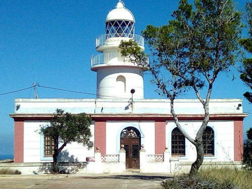
1861 (station established 1855). Active; focal plane 175 m (574 ft); four white flashes every 20 s. 17 m (56 ft) round cylindrical masonry tower with lantern and double gallery, attached to the front of a 1-story masonry keeper's house. Lighthouse painted white with ocher trim; lantern is gray metallic. A photo by Manuel Perez Lopez is at right, Trabas has Rainer Arndt's photo, Xavier Campi has a 2018 closeup photo, Wikimedia has a photo, a distant view is available, Huelse has a historic postcard view, and Google has a street view and a good satellite view. Cabo de San Antonio is the northeastern shoulder of the broad Cabo de la Nao promontory; the lighthouse here is older and has a longer range (42 km or 26 mi) than the one on the point of the cape. The original light was established on a watchtower 250 m (820 ft) from the edge of the cliff; this was too far for the light to be seen from some angles. In 2020 the light station was leased to the town of Jávea, which plans to develop the keeper's house as a visitor center and museum. The renovation was underway in 2023. Located on the cape on the east side of Aduanas, about 2.5 km (1.5 mi) east of Jávea. Site and tower closed, but the lighthouse can be viewed from the end of the Camino del Faro. . ARLHS SPA-021; ES-25300; Admiralty E0180; NGA 5312.
* Cabo de la Nao (Cap de la Nau)
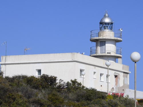
1928 (Jefatura de Alicante). Active; focal plane 122 m (400 ft); white flash every 5 s. 20 m (66 ft) octagonal masonry tower with lantern and gallery, attached to the front of a 1-story masonry keeper's house. Lighthouse painted white with ocher trim; lantern is gray metallic. A 2023 photo is at the top of this page, Trabas has Peter Doll's photo, María Fernando has a photo of the station, Marinas.com has aerial photos, Huelse has a historic postcard view, and Google has a street view and an excellent satellite view. Cabo de la Nao is very prominent cape, the nose of a ridge that continues underwater and reappears to the east as the Balearic Islands. Located on the tip of the cape, at the top of a steep cliff, in the town of Cabo de la Nao. Site and tower appear to be closed, although the lighthouse can be viewed from nearby. ARLHS SPA-018; ES-25200; Admiralty E0176; NGA 5300.

Cabo San Antonio Light, Aduanas, September 2020
Google Maps photo by Manuel Perez Lopez

Marina Baixa Lighthouses
* Marymontaña Breakwater
Date unknown. Active; focal plane about 11 m (36 ft); continuous white light. 6 m (20 ft) round concrete post mounted on a 1-story square concrete equipment shelter. Lighthouse painted green with a white base. Trabas has a good photo and Google has a street view and a satellite view. Located at the end of the breakwater at a small boat harbor in Mascarat, about 3 km (2 mi) northeast of Altea. Accessible by walking the pier. Site open, and it appears that visitors can climb atop the equipment shelter using an external stairway. ES-24985; Admiralty E0174.8.
* Marymontaña Inner Breakwater
Date unknown. Active; focal plane about 11 m (36 ft); continuous red light. 6 m (20 ft) round concrete post mounted on a 1-story square concrete equipment shelter. Upper portion of the lighthouse painted red, lower portion painted white. Trabas has a good photo, Google has a street view, and the shadow of the tower is seen in Google's satellite view. Located at the end of the inner breakwater of Maryontaña. Accessible by walking the pier. Site open, and it appears that visitors can climb atop the equipment shelter using an external stairway. ES-24987; Admiralty E0174.85.
*** Albir (Punta del Albir, Punta Bombarda)
1863 (Antonio Molina). Active; focal plane 112 m (367 ft); three long (1.5 s) white flashes every 27 s. 8 m (26 ft) round cylindrical masonry tower with lantern and gallery, attached to the front of a 1-story masonry keeper's house. Building painted white with ocher trim; lantern is gray metallic. Alexandra Barrett's 2023 photo is at right, Trabas has a photo, a closeup photo is available, Alexandra Barrett has a 2023 photo, Emiliano Gonzalez has a street view, and Google has a satellite view. Between Benidorm and Albir the Costa Blanca is interrupted by a steep-sided mountain, the Sierra Gelada. The lighthouse stands on the eastern tip of this massif with a sweeping view of the Mediterranean. The lighthouse was in poor condition in 2011 when the municipality of Alfàs del Pí acted to restore it as a museum. Accessible by hiking or biking the 2.5 km (1.5 mi) long access road (2 hr round trip) from Albir; there is parking and a visitor center at the trailhead. Site open, museum open daily, tower status unknown. Site manager: Centro de Interpretación Faro de L'Albir. . ARLHS SPA-221; ES-24900; Admiralty E0173.6; NGA 4724.
Islote de Benidorm (1)
Date unknown. Inactive. 4 m (13 ft) round conical tower with gallery and enclosed equipment room. This tower is still listed by NGA, but the light (focal plane 61 m (200 ft); white flash every 3 s) has been moved to a newer concrete tower about 6 m (20 ft) high. Trabas has Werner Seiler's closeup photo and Google has an indistinct satellite view. Located on a small island about 5 km (3 mi) due south of the beach at Benidorm. Accessible only by boat. Site and tower closed. ARLHS SPA-165; ES-24800; Admiralty E0172; NGA 4716.

Punta del Albir Light, Albir, March 2023
Google Maps photo by Alexandra Barrett

Alicantí (Alicante City) Lighthouses
Las Huertas (Cabo Huertas, Cabo de la Huerta) (2)
1980 (station established 1856). Active; focal plane 38 m (125 ft); five white flashes every 19 s. 9 m (30 ft) round cylindrical concrete tower with lantern and two galleries, painted white. Trabas has a photo, Manuel Hernández Lafuente has a good photo, Pilar San Felix has a 2021 photo, a photo of the cape and lighthouse is available, Jorge Gil Sierras has a beach view, and Google has a satellite view. The original lighthouse was a keeper's house with a lantern centered on the roof. The lighthouse is located in a city park called Lomas del Faro. Located on the point of Cabo de la Huerta in Albufereta, about 7 km (4.5 mi) east of the Alicante waterfront. Site and tower closed but the lighthouse can be seen from nearby. . ARLHS SPA-016; ES-24700; Admiralty E0166; NGA 4704.
* Alicante Outer Breakwater (relocated) (2)
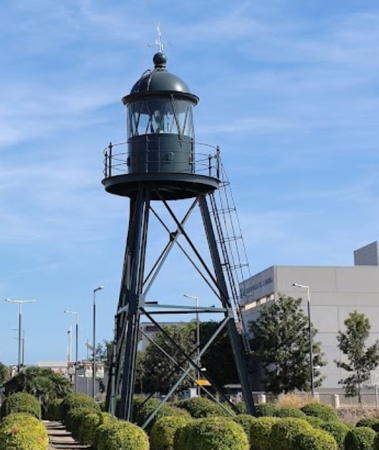
1912 (station established 1855). Inactive since about 2005. 9 m (30 ft) triangular pyramidal skeletal tower with lantern and gallery. Lighthouse painted green. A 2021 photo is at right, a 2023 closeup is available, Huelse has a historic postcard view, and Google has a 2023 street view and a satellite view. Formerly located at the end of the Alicante Breakwater, which extends southwestward about 1.5 km (1 mi) to protect the harbor. Replaced by a copy (next entry), it was relocated (in 2006?) to a roundabout near the entrance to the port and across the street from the city's tourist information center. The lighthouse had also been relocated in 1934 when the breakwater was extended. Located on the Avenida de Oscar Esplá. Site open, tower closed. . ARLHS SPA-096.
Alicante Outer Breakwater (3)
2006 (?). Active; focal plane 14 m (46 ft); green light, 1.5 s on, 3.5 s off. 9 m (30 ft) triangular pyramidal skeletal tower with lantern and gallery, mounted on a square concrete base. Lighthouse painted green. Trabas has a photo, Ruslan Nekrasov has a closeup photo, a 2016 photo is available, Tawfiq Arauz Al-Khatib has a distant street view along the breakwater, and Google has a satellite view. Located at the end of the main breakwater of Alicante. Site and tower closed. ES-24520; Admiralty E0158; NGA 4680.
Alicante Muelle 11
Date unknown. Active; focal plane 7 m (23 ft); four red flashes every 11 s. 6 m (20 ft) post rising from a square 1-story equipment shelter. Post painted red, equipment building white. Trabas has a photo and Google has a satellite view. Located on a wharf opposite the outer breakwater. Site and tower closed. ES-24560; Admiralty E0159.3; NGA 4696.
Alicante Dársena Pesquera (Fishing Harbor)
Date unknown. Active; focal plane 7 m (23 ft); three red flashes every 9 s. 6 m (20 ft) post rising from a square 1-story equipment shelter. Post painted red, equipment building white. Trabas has Eckhard Meyer's photo and Google has a satellite view and a street view from the containership pier. The old fishing harbor is now used by recreational boaters. Located at the end of the breakwater of the small boat harbor. Site and tower closed. ES-24511; Admiralty E0157.7.

Alicante Light, Alicante,October 2021
Google Maps photo
by Alejandria 10

Baix Vinalopó Lighthouses
* Santa Pola (Torre Talayola)
1858. Active; focal plane 152 m (499 ft); three white flashes, in a 1+2 pattern, every 20 s. 15 m (49 ft) square masonry tower with lantern and gallery, centered on the roof of a 1-story masonry keeper's house. Lighthouse painted white; lantern is gray metallic. Trabas has a photo, Susie Solo has another good closeup photo, a 2018 photo is available, and Google has a street view and a satellite view. The lighthouse is built atop a spectacular cliff famous among paleontologists for its exposure of Miocene fossils. Located about 4 km (2.5 mi) east of the town of Santa Pola. A parking area for visitors was built in 2017. Site and tower closed but there's a good view from the nearby mirador (viewing platform). ARLHS SPA-046; ES-24400; Admiralty E0152; NGA 4664.
* Isla de Tabarca (Isla Plana) (1)
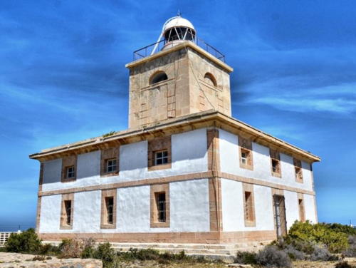
1854 (Agustín Elcoro y Berocíbar). Reactivated (inactive 1971-?); focal plane 29 m (95 ft); white light occulting twice every 10 s. 14 m (56 ft) square cylindrical masonry tower with lantern and gallery, centered on the roof of a 2-story masonry keeper's house. The light tower is unpainted gray stone; the keeper's house is white with unpainted stone trim. Guido Douven's 2023 photo is at right, Wikimedia has a collection of photos, Trabas has Rainer Arndt's photo, Fernando Patacona has a 2021 photo, Alessandro Pavan has a 2007 photo, Paco Fabregat has a street view, and Google has a satellite view. This historic lighthouse was taken out of service in 1971 and replaced by a cylindrical concrete tower with lantern and double gallery. Recent photos show that tower has disappeared and a lantern has been mounted once again on the historic lighthouse; we need details concerning this restoration. The lighthouse now serves as the headquarters and laboratory of a marine reserve. The Isla de Tabarca, also called Isla Plana (Flat Island), is a small island about 10 km (6 mi) southeast of Santa Pola. Transportation to the island is available in Santa Pola. Located at the eastern end of the island. Site open, tower closed. Site manager: Reserva Marina de Tabarca. . ARLHS SPA-136; ES-24270; Admiralty E0148; NGA 4652.

Isla de Tabarca Light, Santa Pola, December 2023
Google Maps photo
by Guido Douven

Baix Segura Lighthouses
* [Torrevieja Dique de Levante (East Breakwater)]
Date unknown. Active; focal plane 15 m (49 ft); green flash every 3 s. 10 m (33 ft) unpainted octagonal stone tower. Trabas has a closeup photo, Wikimedia has a photo, Juan Soler Valoria has a closeup street view, and Google has a satellite view. Located at the end of the east breakwater of Torrevieja. Accessible by walking the pier. Site open, tower closed. ARLHS SPA-299; ES-24160; Admiralty E0146; NGA 4640.
* Torrevieja Muelle de la Sal (West Breakwater)
Date unknown. Active; focal plane 11 m (36 ft); three red flashes every 11.5 s. 6.5 m (21 ft) octagonal concrete tower. Upper half painted red, lower half white. Trabas has a closeup photo, Andreas Köhler has a photo, and Google has a satellite view. Located at the end of the west breakwater of Torrevieja. Accessible by walking the pier. Site open, tower closed. ES-24170; Admiralty E0146.2; NGA 4644.

Murcia Region Lighthouses

Lighthouses in Murcia are operated and maintained by the Autoridad Portuaria de Cartagena. The region's principal seaport, Cartagena, is a historic city founded by Carthaginians in the third century BCE; for centuries it has been the home port of Spain's Mediterranean Fleet. The coast of Murcia is called the Costa Cálida (Warm Coast).

Mar Menor Lighthouses
* El Estacio (2)
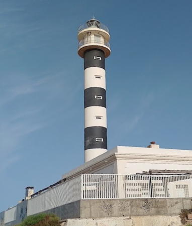
1976 (station established 1862). Active; focal plane 32 m (105 ft); four white flashes every 20 s. 29 m (95 ft) round cylindrical concrete tower with lantern and double gallery, painted with black and white horizontal bands. The original (1862) keeper's house survives. Ruut Nieminen's 2022 photo is at right, Trabas has a good photo, Wikimedia has a fine photo, Alberto Lopez also has a photo, and Google has a street view and a satellite view. Sibling of the 1973 Águilas lighthouse (see below). The original lighthouse was a 15 m (49 ft) octagonal masonry tower designed by Carlos Mondéjar. North of Cabo de Palos a sandy barrier beach surrounds the Mar Menor, a saltwater lagoon about 20 km (13 mi) long. The lighthouse is located midway along this barrier at the Punta del Estacio, on the north side of an inlet that gives access to the Mar Menor. The site is accessible by road from Cabo de Palos. Site open, tower closed. ARLHS SPA-088; ES-23950; Admiralty E0140; NGA 4624.
[Isla Grosa]
Date unknown. Active; focal plane 97 m (318 ft); white flash every 3 s. 4 m (13 ft) mast atop a round white concrete base. Trabas has a very distant view from shore and Google has a satellite view. Located at the summit of Isla Grosa, a very steep rocky island about 2 km (1.25 mi) southeast of the entrance to the Mar Menor. Inaccessible; site and tower closed. ES-23900; Admiralty E0139; NGA 4628.
Los Alcázares (Infanta Cristina Pier)
Date unknown. Active; focal plane about 8 m (26 ft); light characteristic unknown. 7 m (23 ft) mast atop a 1-story harbor control office. Trabas has a photo, Laura García has a view from the shore, and Google has a satellite view. Located at the end of the main pier at Los Alcázares, a resort town on the west (mainland) side of the Mar Menor. Probably accessible by walking the pier. Site open, tower closed. ES-23970; Admiralty E0141.28.

Campo de Cartagena Lighthouses
Las Hormigas (Hormiga Grande)
1862 (Carlos Mondéjar). Active; focal plane 24 m (79 ft); three white flashes every 14 s. 12 m (39 ft) round cylindrical masonry tower with lantern and gallery, centered on the roof of a circular masonry keeper's house. Entire lighthouse painted white. José Francisco Calvo has a photo, Trabas has Jim Smith's photo, Gonzalo Nistal Alcoba has a 2023 photo, and Google has a satellite view. Spanish sailors often refer to a group of small rocks as hormigas (ants). Located on a small rocky islet about 4 km (2.5 mi) northeast of Cabo de Palos; easily visible from the Faro de Palos. Accessible only by boat. Site and tower closed. ARLHS SPA-140; ES-23850; Admiralty E0138; NGA 4616.

El Estacio Light, La Manga, June 2022
Gogle Maps photo
by Ruut Nieminen
*** Cabo de Palos
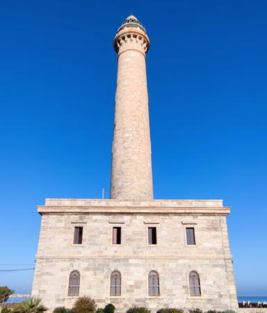
1865 (Carlos Mondéjar). Active; focal plane 81 m (266 ft); two white flashes every 10 s. 51 m (167 ft) round stone tower with lantern and gallery, rising from a 2-story stone keeper's house. The lighthouse is unpainted gray stone. Fog siren (Morse code "P": short, two longs, and a short, every 40 s. A 2022 photo is at right, Trabas also has a good photo, Victor Chaves has a 2018 photo, Marinas.com has aerial photos, and Google has a street view and a good satellite view. This great lighthouse resembles the Chipiona lighthouse at Seville and the Punta Carnero lighthouse at Algeciras; like those lighthouses, it is probably the work of the engineer Jaime Font. Activities were held in the spring of 2015 to mark the 150th anniversary of the lighthouse. In 2017 a proposal to convert the light station to a luxury boutique hotel was firmly rejected by the provincial government. Area residents formed a preservation group to fight any new proposals for privatization of the light station. In 2019 the port authority licensed several tour companies to offer tours of the lighthouse. The Cabo de Palos is the central cape of the three great capes of southeastern Spain, the others being Cabo de Gata in Almería (see the Eastern Andalusia page) and Cabo de la Nao in Alicante (see above). Located on the point of the cape, a narrow peninsula extending about 1.5 km (1 mi) eastward into the Mediterranean at the town of Cabo de Palos. Site open, tower open to guided tours (online reservations required). ARLHS SPA-019; ES-23800; Admiralty E0136.8; NGA 4600.
* Portmán (Punta de la Chapa)
1865 (Leonardo Tejada). Active; focal plane 49 m (161 ft); white light, 2.5 s on, 1 s off. 8 m (26 ft) round cylindrical masonry tower with lantern and gallery, rising from a 1-story keeper's house. Lighthouse painted white; lantern dome is gray metallic. Trabas has Meyer's photo, a 2022 photo is available, Juan Ramón Martínez Inglés also has a fine photo, Klaus Schlitt has a street view, and Google has a satellite view. Located on a promontory about 3 km (2 mi) southeast of Portmán and 10 km (6 mi) east of Cartagena. Site open, tower closed. . ARLHS SPA-211; ES-23660; Admiralty E0134; NGA 4596.
Escombreras (Islote de Escombreras)
1864 (Antonio Molina). Active; focal plane 65 m (213 ft); white flash every 5 s. 8 m (26 ft) round cylindrical masonry tower rising from a 1-story keeper's house. Lighthouse painted white; lantern dome is gray metallic. Trabas has Capt. Peter Mosselberger's photo, a 2011 photo is available, Huelse has a historic postcard closeup, and Google has a satellite view. The Islote de Escombreras is a small, steep-sided island off the eastern entrance to the bay of Cartagena. The island helps shelter the industrial harbor of Escombreras. A new breakwater hooks around the north side of the island, but does not connect to it. Located on the peak of the island. Accessible only by boat. Site and tower closed. . ARLHS SPA-167; ES-23190; Admiralty E0126; NGA 4564.

Cabo de Palos Light, Cabo de Palos, December 2022
Google Maps photo by El Comandante
* Cartagena Dique de la Curra
1892. Active; focal plane 14 m (46 ft); three green flashes every 14 s. 11 m (36 ft) round concrete tower with lantern and castellated gallery. The lantern and upper third of the tower are painted green, the rest of the tower white. Trabas has Capt. Peter Mosselberger's closeup, another good photo is available, Salvador Ruiz Pérez has a 2022 closeup, and Google has a street view and a satellite view. This light stands at the end of the Dique de la Curra, the main breakwater, which projects from the east side of Cartagena harbor. Accessible by walking the breakwater. Site open, tower closed. ARLHS SPA-087; ES-23470; Admiralty E0130; NGA 4592.
* Navidad (Cartagena Dique de la Navidad) (2)
1892 (station established 1875). Active; focal plane 15 m (49 ft); two red flashes every 10 s. 11 m (36 ft) round concrete tower with lantern and gallery. The lantern and upper third of the tower are painted red, the rest of the tower white with red trim. A photo by Cristina Mª Granados Roas is at right, Trabas has Capt. Peter Mosselberger's closeup, another closeup photo is available, Huelse has a historic postcard view, Víctor Caballero has a street view, and Google has a satellite view. This handsome little lighthouse is a familiar sight of Cartagena harbor. It stands at the end of the Dique de la Navidad, a breakwater mole projecting from the west side of the harbor entrance. A shipwreck museum, the Museo Nacional de Arqueología Subacuática, is at the base of the breakwater. Accessible by walking the breakwater. Site open, tower closed. ARLHS SPA-103; ES-23450; Admiralty E0128; NGA 4588.
* Podadera (2)
1866 (station established 1856). Inactive since the 1890s. Approx. 7.5 m (25 ft) round cylindrical stone tower attached to a 1-story stone keeper's house. The lighthouse is unpainted. Lantern and gallery removed. Alberto Rodriguez has a closeup 2018 photo, Santiago Serrano Egea has another closeup photo, Klaus Schlitt has a street view from a ruined 19th century fort below the lighthouse, and Google has a satellite view. Endangered. The building is sealed but abandoned and decorated with graffiti. The lighthouse was deactivated shortly after the Dique de la Curra and Navidad lighthouses were completed in 1892. Located on a promontory on the west side of the entrance to Cartagena harbor, above the fortifications of the Bateria de Podadera. Site open, tower closed. ARLHS SPA-349.
* Cabo Tiñoso
1859 (extensively rebuilt in 1970). Active; focal plane 146 m (479 ft); four white flashes, in a 1+3 pattern, every 20 s. 10 m (30 ft) robust round cylindrical masonry tower with lantern and double gallery attached to a 1-story keeper's house. Lighthouse painted white; lantern dome is gray metallic. Manuel Hernández Lafuente has a closeup photo, Trabas has a closeup, Alberto Rodriguez has a 2018 photo, and Google has a satellite view. The original lantern was removed and the tower was rebuilt in 1970, altering its historic appearance. The lighthouse has a range of 24 nautical miles (44.5 km, 27.5 mi), standing atop spectacular cliffs on a rugged promontory southwest of Cartagena. The surrounding waters are a marine reserve, the Cabo Tiñoso-La Azohía Reserva Marina. Located about 15 km (9 mi) west southwest of Cartagena, but at least three or four times that far by circuitous mountain roads. Site open, tower closed. ARLHS SPA-048; ES-23070; Admiralty E0124; NGA 4548.

Dique de la Navidad Light, Cartagena, July 2023
Instagram photo by Cristina Mª Granados Roas

Bajo Guadalentín Lighthouse
* Mazarrón (2)
1974 (Carlos Mondéjar) (station established 1862). Active; focal plane 65 m (213 ft); white light occulting three times, in a 1+2 pattern, every 13.5 s. 11 m (36 ft) round cylindrical concrete tower with lantern and double gallery, painted white. The lighthouse is adjacent to a 1-story equipment building, also painted white. A photo by Joaquin Riquelme Añon is at right, Trabas also has a good photo, Joaquin Riquelme Añon has a 2018 photo, a photo of the light in action is available, and Google has a street view and a satellite view. Accessible by a short walk (the lighthouse drive is closed to cars). Located on a steep headland south of the harbor of Mazarrón. Site and tower closed but the lighthouse can be seen from nearby. . ARLHS SPA-084; ES-23000; Admiralty E0120; NGA 4536.

Alto Guadalentín Lighthouses
Islote de la Aguilica
Date unknown. Active; focal plane 19 m (62 ft); green flash every 3 s. 10 m (33 ft) multistage square concrete tower painted white. Trabas has a closeup photo, Isaac Martinez has a street view, and Google has a satellite view. Located on a tiny island just of the east side of the entrance to the harbor of Águilas. Accessible only by boat. Site open, tower closed. ARLHS SPA-006; ES-22940; Admiralty E0117.5; NGA 4532.
* Águilas (Punta Negra) (2)
1973 (station established 1860). Active; focal plane 30 m (98 ft); two white flashes every 5 s. 23 m (75 ft) round cylindrical concrete tower with lantern and double gallery, painted with black and white horizontal bands. The lighthouse is adjacent to a 2-story square crew or administration building. Ricardo Codorniu has an excellent photo, Trabas also has a good photo, and Google has a street view and a satellite view. Huelse has a historic postcard view of the station in its original form. Located on Punta Negra, at the west entrance to the harbor of Águilas. Site open, tower closed. ARLHS SPA-246; ES-22900; Admiralty E0114; NGA 4524.

Mazarrón Light, Mazarrón, May 2018
Google Maps photo by Joaquin Riquelme Añon

Information available on lost lighthouses:

Notable faux lighthouses:

Adjoining pages: North: Catalonia | East: Ibiza and Formentera | West: Eastern Andalusia

Return to the Lighthouse Directory index | Ratings key

Posted February 20, 2006. Checked and revised June 10, 2024. Lighthouses: 45. Site copyright 2024 Russ Rowlett and the University of North Carolina at Chapel Hill.