Lighthouses of Southern Portugal

Facing the Atlantic Ocean at the southwestern corner of Europe, Portugal (officially the Portuguese Republic, República Portuguesa) has a very distinguished maritime history. Portuguese sailors launched and led the European age of discovery and Portuguese ships have been returning home from the far corners of the globe for about 600 years. It's not surprising that lighthouses have played an important role in Portuguese culture and that they are treasured national monuments today.

Portugal is divided for statistical purposes into 18 districts. This page has information on the lighthouses of the southern part of the Portuguese mainland in the Faro and Beja districts. There are also pages for Central Portugal and Northern Portugal. Lighthouses of the Azores and Madeira, islands discovered and settled by the early Portuguese explorers, are also on separate pages.

The Portuguese word for a lighthouse is farol, plural faróis; a small lightbeacon is often called a farolim. In Portuguese ilha is an island, ilhéu is an islet, cabo is a cape, ponta is a promontory or point of land, rocha is a rock, recife is a reef, baía is a bay, estreito is a strait, rio is a river, and porto is a port or harbor.

Formerly owned by the Navy, the lighthouses in Portugal are now operated by the Lighthouse Directorate (Direção de Faróis), an agency of the National Maritime Authority (Autoridade Marítima Nacional).

ARLHS numbers are from the ARLHS World List of Lights. PT numbers are from the Portuguese light list, as recorded by the Portuguese Wikipedia. Admiralty numbers are from volume D of the Admiralty List of Lights & Fog Signals. U.S. NGA List numbers are from Publication 113.

General Sources
Faroís
Lighthouse information from the Direção de Faróis.
Online List of Lights - Portugal
Photos by various photographers posted by Alexander Trabas.
Lighthouses in Portugal
Excellent aerial photos posted by Marinas.com.
Faróis de Portugal
Portuguese Wikipedia article on the country's lighthouses. Near the bottom of the page are links to pages for the individual lighthouses. The photos are also available in Wikimedia's Lighthouses in Portugal category.
World of Lighthouses - Portugal
Photos by various photographers available from Lightphotos.net.
Faróis de Portugal
Fine recent photos posted on Flickr.com by Carlos Olmo Bosco.
Phares d'Europe
Photos posted by Alain Guyomard and Robert Carceller.
Lighthouses of Portugal
Historic postcard images collected by Michel Forand.
Leuchttürme Portugals auf historischen Postkarten
Historic postcard images collected by Klaus Huelse.
GPSNauticalCharts
Navigational chart for Portugal.
Navionics Charts
Navigational chart for Portugal.

Faro de Vila
Vila Real de Santo António Light, April 2007
Wikimedia Creative Commons photo
by Marc Ryckaert

Faro District (Algarve) Lighthouses

The Algarve, Portugal's south coast, is famous worldwide for its beaches and resorts. All of the Algarve is included in the Faro District. The name Algarve is fron the Arabic al-gharb ("the west").

Vila Real de Santo António Lighthouses
* Rio Guadiana West Mole (2)
Date unknown. Active; focal plane 10 m (33 ft); red flash every 3 s. 5 m (17 ft) round tower painted with red and white horizontal bands. Pepe Cerillo has a photo, Trabas has Eckhard Meyer's photo, Eduardo Lucas has a closeup street view and Google has a satellite view. This light replaced a skeletal tower seen in a 2009 photo by Nuno Moura Neves. Located on the west breakwater at the mouth of the Rio Guadiana, which forms the border between Portugal and Spain. Accessible by walking the pier. Site open, tower closed. PT-597; Admiralty D2249; NGA 3800.
** Vila Real de Santo António
1923. Active; focal plane 52 m (171 ft); white flash every 6.5 s. 46 m (151 ft) round concrete (?) tower with lantern and gallery, attached to a 2-story keeper's complex. Lighthouse is white with narrow black horizontal bands; lantern painted red. Marc Ryckaert's photo is above, Carlos Olmo has a great photo, Trabas also has an excellent closeup photo, Walace Elias has a 2021 photo, Huelse has a historic postcard view, and Google has a street view and a satellite view. This lighthouse marks the entrance to the Rio Guadiana. Located on the west side of the river, on the Estrada da Mata, in Vila Real de Santo António. Site open, tower open Wednesday afternoons. . ARLHS POR-057; PT-590; Admiralty D2246; NGA 3816.

Olhão Lighthouses
* Fuzeta (Fuseta, Igreja Matriz da Fuzeta) (2)
Date unknown (station established 1887). Active; focal plane 31 m (102 ft); red light occulting once every 3 s. 17 m (56 ft) lantern atop a white church belltower. Trabas has a closeup photo and Google has a street view and a satellite view. Located in Fuzeta, a small fishing port about 8 km (5 mi) east of Olhão. Site open, tower closed. Site manager: Igreja Matriz. ARLHS POR-074; Admiralty D2230.1; NGA 3772.
* Olhão Range Front
Date unknown. Active; focal plane 8 m (26 ft); red light, 3 s on, 3 s off. 7 m (23 ft) small round cylindrical tower, painted with a white and a red horizontal band, mounted atop a 1-story building in use as a fishmonger's shop. Trabas has a photo by José Da Palma and Google has a street view and a satellite view. Located on the waterfront of Olhão. Site open, tower closed. PT-551; Admiralty D2226.
* Olhão Range Rear
Date unknown. Active; focal plane 20 m (66 ft); red light, 2.5 s on, 1.5 s off. 12 m (39 ft) light mounted atop a historic church, the 17th century Igreja Matriz de Nossa Senhora do Rosário. Trabas has a photo by José Da Palma and Google has a street view and a satellite view. Located in downtown Olhão, 360 m (1/4 mi) from the front light. Site open, tower closed. Admiralty D2226.1.

Faro Lighthouses
** Cabo de Santa Maria (2)
1996 (reconstruction of 1851 lighthouse). Active; focal plane 50 m (164 ft); four white flashes every 17 s. 46 m (151 ft) round concrete tower with lantern and gallery, rising from a 2-story circular masonry base, attached by an enclosed corridor to a large 1-story keeper's complex. Lighthouse is white, lantern red. Osvaldo Gago's photo is at right, Trabas has José da Palma's photo, Wikimedia has additional photos, Marinas.com has aerial photos, Huelse has a postcard view of the original lighthouse, and Google has a street view and a great satellite view. The height of the tower was increased from 34 m (112 ft) in 1922. This led to an instability in the tower, so in 1929 the lighthouse was "consolidated" with the robust concrete form seen today. The extent of the "consolidation" is not clear; it may be that most of the original lighthouse was demolished and replaced by a new tower built on the 2-story base of the original. In 1995-97 there was an extensive restoration that included replacement of the lantern. Cabo de Santa Maria is the southernmost point of Portugal, at the edge of an extensive area of dunes, marshes, and channels incorporated in a national park, the Parque Natural da Ria Formosa. Located on a barrier island on the east side of the entrance to the channel leading to Faro, about 12 km (7.5 mi) southeast of the city. Accessible only by boat; tours to the area are available. Site open, tower open Wednesday afternoons. . ARLHS POR-013; PT-505; Admiralty D2206; NGA 3724.
* Barra Faro-Olhão East Mole
Date unknown. Active; focal plane 10 m (32 ft); green flash every 4 s. 8 m (26 ft) round concrete tower painted with green and white horizontal bands. Trabas has José da Palma's closeup photo, Marco Atraca has a street view, and Google has a satellite view. Located on the east mole of the estuary entrance. Accessible by walking the pier. Site open, tower closed. PT-504; Admiralty D2209; NGA 3732.
* [Barra Faro-Olhão Range Front]
Date unknown. Active; focal plane 9 m (30 ft); white light occulting once every 4 s. 7 m (23 ft) slender round tower painted with red and white horizontal bands. Trabas has Werner Seiler's closeup photo and Google has a satellite view. This is the entrance range for the Ria Formosa estuary; the Cabo de Santa Maria lighthouse is the rear light. Located near the foot of the east mole of the estuary entrance. Accessible by walking the pier. Site open, tower closed. Admiralty D2206.1; NGA 3736.
* Ilha de Culatra
Date unknown. Active; focal plane 7 m (23 ft); green light occulting every 5 s. Light mounted above the doors of a boathouse. Trabas has Eckhard Meyer's closeup photo and Google has a satellite view. Located on the east side of the Ria Formosa entrance, west of the Cabo de Santa Maria lighthouse. Site open, tower closed. Admiralty D2211; NGA 3748.
* [Faro Range Front (2)]
Date unknown. Active; focal plane 11 m (36 ft); red flash every 3 s. 6 m (20 ft) post. Trabas has a photo and Google has a street view and a satellite view. This range guides vessels in the narrow channel approaching Faro. The light was formerly mounted atop a factory building; the light was moved because the abandoned factory collapsed. Located on the waterfront of Faro. Site open, tower closed. Admiralty PT-512; D2214.

Farol de Santa Maria
Cabo de Santa Maria Light, May 2006
Wikimedia Creative Commons photo
by Osvaldo Gago

* Faro Range Rear
Date unknown. Active; focal plane 63 m (207 ft); red light occulting once every 6 s. 21 m (69 ft) square concrete church tower with a light mounted at the top. Trabas has a photo and Google has a street view and a satellite view. Located at the church of Santo António do Alto in Faro. Site open, tower closed. PT-513; Admiralty D2214.1.
* Barra Faro-Olhão West Mole
Date unknown. Active; focal plane 10 m (32 ft); red flash every 4 s. 8 m (26 ft) round concrete tower painted with red and white horizontal bands. Trabas has José da Palma's photo, Fabiana Teles has a photo, and Google has a satellite view. Located on the west mole of the estuary entrance. Accessible by walking the pier. Site open, tower closed. PT-503; Admiralty D2208; NGA 3728.

Loulé Lighthouses
* Quarteira East Mole
Date unknown. Active; focal plane 12 m (39 ft); green flash every 3 s. 6 m (20 ft) pentagonal tower with gallery, painted with green and white horizontal bands. Trabas has a photo, Shaukos Bezons has a 2016 closeup, and Google has a street view and a satellite view. Located at the end of a mole in Quarteira. Site open, tower closed. ARLHS POR-089; PT-495; Admiralty D2198.3.
* Quarteira West Mole (2)
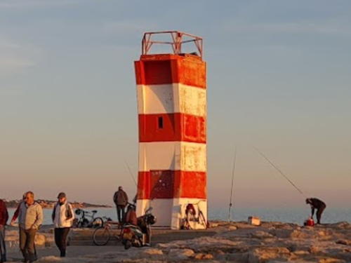
Date unknown (around 2010). Active; focal plane 12 m (39 ft); red flash every 3 s. 6 m (20 ft) round strongly conical tower with gallery, painted with red and white horizontal bands. A 2023 photo by José Ricardo Fernandes is at right, Trabas has a photo, Dash Virdee has a closeup, and Google has a street view and a satellite view. Located at the end of a mole in Quarteira, about 1.5 km (1 mi) east of the Vilamoura Marina. Site open, tower closed. ARLHS POR-096; PT-494; Admiralty D2198.1.
* Vilamoura Marina East Mole
Date unknown. Active; focal plane 14 m (46 ft); green flash every 4 s. 7 m (23 ft) round bluntly conical tower with gallery, painted with green and white horizontal bands. Trabas has a photo and Google has a street view and a satellite view. Located at the end of the mole on the east side of the entrance to the Vilamoura Marina. Site open, tower closed. ARLHS POR-083; PT-493; Admiralty D2197.4; NGA 3712.
 

Quarteira West Mole Light, Vilamoura, January 2023
Google Maps photo by José Ricardo Fernandes
 
* Vilamoura
Date unknown (modern). Active; focal plane 18 m (59 ft); white flash every 5 s. 16 m (52 ft) round concrete cylindrical control tower with the light on a skeletal mast on the top. Trabas has a closeup, Shaukos Bezons has a photo, and Google has a street view and a satellite view. The artificial harbor of Vilamoura, about 20 km (13 mi) west of Faro, is probably the largest yacht harbor on the Algarve, with over 100 berths. Located on the west side of the harbor, about 5 km (3 mi) south of the village of Vilamoura. Site open, tower closed. ARLHS POR-041; PT-491; Admiralty D2197.2; NGA 3716.
* Vilamoura Marina West Mole
Date unknown. Active; focal plane 14 m (46 ft); red flash every 4 s. 7 m (23 ft) round bluntly conical tower with gallery, painted with red and white horizontal bands. Trabas has a closeup photo, Shaukos Bezons has a 2016 closeup, and Google has a street view and a satellite view. Located at the end of the mole on the west side of the entrance to the Vilamoura Marina. Site open, tower closed. ARLHS POR-062; PT-492; Admiralty D2197.3; NGA 3708.

Silves Lighthouse
* Armação de Pera
Date unknown. Active; focal plane 30 m (98 ft); white light, 2 s on, 3 s off. Light mounted atop a 7-story waterfront condo building. Trabas has a closeup photo and Google has a street view and a satellite view. Located opposite the beach in Armação de Pera, a popular beach resort. Site open, tower closed. Admiralty D2194; NGA 3688.

Lagoa Lighthouse
** Alfanzina
1920. Active; focal plane 56 m (184 ft); two white flashes every 15 s. 23 m (75 ft) square masonry tower with lantern and gallery, attached to the front of a 1-story keeper's complex. 3rd order Fresnel lens in use. The faces of the tower are covered with white tiles; lantern painted red. A Direção de Faróis photo is at right, Larry Myhre has a photo, Rui Ornelas has a photo, Ricardo Santos has a photo of the lighthouse in action, a 2021 photo is available, Trabas has Klaus Kern's photo, Carlos Olmo also has a good photo, and Google has a street view and a satellite view. Located on a rocky promontory off the N530 highway about 15 km (9 mi) southeast of Lagoa. Accessible by road; parking available. Site open, tower open Wednesday afternoons. . ARLHS POR-001; PT-478; Admiralty D2192; NGA 3684.

Alfanzina Light, Lagoa
Direção de Faróis photo

Portimão Lighthouses
** Ponta do Altar
1893. Active; focal plane 32 m (105 ft); white light, 2 s on, 3 s off. 10 m (33 ft) square cylindrical masonry tower with lantern and gallery, rising schoolhouse-style from the front of a 1-story masonry keeper's house. Building painted white with red trim and a red tile roof; lantern painted red. A photo is at right, Trabas has Eckhard Meyer's photo, a 2021 photo is available, and Google has a street view and a satellite view. This is an unusual design for a Portuguese lighthouse. When C.W. Bash visited this site in 2007 he photographed a new concrete communications tower beside the lighthouse. Located on a promontory on the east side of the entrance to the harbor of Portimão, about 7 km (4.5 mi) south southeast of the city. Accessible by road; parking available. Site open, tower open Wednesday afternoons. . ARLHS POR-044; PT-475; Admiralty D2178; NGA 3644.
* Portimão East Mole
Date unknown. Active; focal plane 10 m (33 ft); green flash every 5 s. 7 m (23 ft) round bluntly conical tower with gallery, painted with green and white horizontal bands. Trabas has a photo, Benjamin Drucker has a 2022 closeup, Carlos Alcobia has a street view, and Google has a satellite view. Located at the end of the mole on the east side of the entrance to Portimão harbor. Site open, tower closed. ARLHS POR-092; PT-459; Admiralty D2179.2; NGA 3652.
* Portimão West Mole
Date unknown. Active; focal plane 10 m (33 ft); red flash every 5 s. 7 m (23 ft) round bluntly conical tower with gallery, painted with red and white horizontal bands. Trabas has a photo, Carlos Fonseca has a street view, and Google has a satellite view. Located at the end of the mole on the west side of the entrance to Portimão harbor. Site open, tower closed. ARLHS POR-093; Admiralty D2179; NGA 3648.

Ponta do Altar Light, Portimão, March 2016
Wikimedia Creative Commons photo by muffinn

Lagos Lighthouses
Lagos is only a small, resort-oriented city today, but it has a long history and played an important role in Portugal's great age of discovery. Prince Henry the Navigator (1394-1460) lived much of his life in Lagos and neighboring Sagres and directed Portugal's discoverers from here. The great city of Lagos, Nigeria, is believed to be named for Lagos, Portugal.
* Lagos East Mole
Date unknown. Active; focal plane 10 m (33 ft); green flash every 5 s. 6 m (20 ft) rectangular pyramidal concrete tower with gallery, painted with green and white horizontal bands. Access to the gallery is by steps cut into the slanted side of the tower. Trabas has Eckhard Meyer's photo and Google has a street view and a satellite view. Located at the end of the mole on the east side of the entrance to Lagos harbor. Site open, tower closed. ARLHS POR-090; Admiralty D2176; NGA 3632.
* Lagos West Mole
Date unknown. Active; focal plane 10 m (33 ft); two red flashes every 6 s. 7 m (23 ft) rectangular pyramidal concrete tower with gallery, painted with red and white horizontal bands. Access to the gallery is by steps cut into the slanted side of the tower. Trabas has Eckhard Meyer's photo, Pedro Geraldes has a closeup street view, and Google has a satellite view. Located at the end of the mole on the west side of the entrance to Lagos harbor. Site open, tower closed. ARLHS POR-091; PT-450; Admiralty D2175; NGA 3628.
** Ponta da Piedade (Lagos)
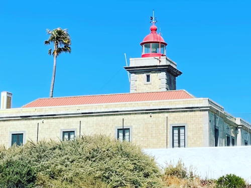
1913. Active; focal plane 51 m (167 ft); white flash every 7 s. Approx. 10 m (33 ft) square cylindrical masonry tower, attached to the front of a 1-story masonry keeper's house. 4th order Fresnel lens in use. The unpainted building is faced with yellow-brown tiles; lantern painted red. Dustin Whittle's photo is at right, Trabas has Eckhard Meyer's closeup photo, Francisco López has a 2022 photo, Huelse has a historic postcard view, and Google has a street view and a satellite view. Located at the end of the N536 highway about 2.5 km (1.5 mi) south of Lagos. Site and tower open Wednesday afternoons (the station is fenced), but the lighthouse can be viewed from nearby. . ARLHS POR-042; PT-445; Admiralty D2174; NGA 3624.

Ponta da Piedade Light, Lagos, January 2022
Instagram photo by Dustin Whittle

Vila do Bispo Lighthouses
* Burgau Posto
Date unknown. Active; focal plane 16 m (52 ft); white light, 2 s on, 3 s off. Light in a small red lantern mounted near the top of a 1-story post office building in Burgau. Trabas has Andreas Köhler's closeup photo of the lens and Google has a street view and a satellite view. Burgau is a former fishing village, now a popular beach resort. Site open, building status unknown. Admiralty D2172.3; NGA 3623.
* Baleeira (Sagres Breakwater)
Date unknown. Active; focal plane 13 m (43 ft); flash every 4 s, white or red depending on direction. 6 m (20 ft) round tower, painted with horizontal red and white bands. Trabas has Eckhard Meyer's closeup photo, and Google has a satellite view and a distant street view from the base of the pier. Located at the end of the breakwater on the west side of the bay of Baleeira, the harbor of Sagres. Site open, tower closed. ARLHS POR-066; Admiralty D2171; NGA 3622.
Ponta de Sagres (3)
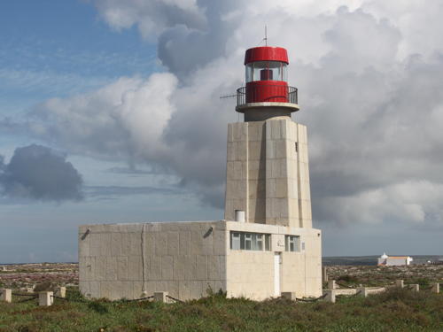
1960 (station established 1894). Active; focal plane 53 m (174 ft); red light, 1 s on, 1 s off. 13 m (43 ft) square concrete tower with lantern and gallery, attached to a 1-story equipment building. The tower is unpainted concrete; the lantern is white with a red roof. A photo is at right, Trabas has a good photo, Lightphotos.net has a 2012 photo, a 2021 closeup is available, Huelse has an older black-and-white photo of the present station, Aleksejs Vasiljevs has a street view, and Google has a good satellite view. Huelse also has a postcard view of the second (1923) lighthouse, which was located about 500 m (0.3 mi) north within the historic Fortaleza de Sagres. The building was demolished after being replaced in 1960 but its foundation can be seen in a Google satellite view. It was at his villa in Sagres between 1415 and 1460 that Dom Henrique (Prince Henry the Navigator) planned explorations of the coast of West Africa, thus powering the great Portuguese discoveries soon to come in Africa, Brazil and the Orient. The town is on the east side of the Cabo de São Vicente, sheltered by the long finger of the Ponta de Sagres. Located at the end of the peninsula, about 2 km (1.2 mi) south of Sagres. Accessible by road. Site status unknown. . ARLHS POR-043; PT-440; Admiralty D2170; NGA 3620.

Ponta de Sagres Light, Sagres, April 2015
Wikimedia Creative Commons photo by Rodw
** Cabo de São Vicente (3)
1846 (extensively rebuilt 1908; station established around 1515). Active; focal plane 86 m (282 ft); one quick white flash every 5 s. 28 m (92 ft) round cylindrical stone tower with lantern and gallery, rising from a 2- and 3-story keeper's complex. A hyper-radiant Fresnel lens (larger than 1st order) has been in use since 1908. The light tower is unpainted; lantern painted red; keeper's houses painted white with red roofs. Fog horn (two 5 s blasts every 30 s). Matthias Süßen's photo is at right, Trabas has a closeup photo, Marjolein Vegers has a 2008 photo, the Lighthouse Directorate's page has good photos, Andrey Kolganov has a closeup street view, Huelse has a historic postcard view, and Google has a good satellite view and a street view from the parking area. This is one of the world's great lighthouses and Portugal's most famous lighthouse. Cape St. Vincent is the traditional "land's end" of Europe, the extreme southwesternmost point of the continent, the essential landfall for sailors returning from Africa or the Orient. Lights were shown from the Convent of São Vicente early in the 1500s but the convent and light tower were destroyed in a raid by Sir Frances Drake in 1587. A new light tower was built in 1606. The present lighthouse, placed in service in 1846, was poorly maintained for many years. A large-scale reconstruction, ordered in 1897 and completed in 1908, included the installation of one of the largest Fresnel lenses ever built; only a handful of these great lenses remain in service anywhere. The light was automated in 1982 but a small staff remains on duty. Since the light station attracts thousands of visitors annually the navy constructed a small visitor center and museum on the site. Located atop spectacular cliffs at the point of the cape, about 7 km (4.5 mi) west of Sagres. Site and museum open, tower open Wednesday afternoons. . ARLHS POR-012; PT-436; Admiralty D2168; NGA 3616.

Cabo de São Vicente Light, March 2016
Wikimedia Creative Commons photo by Matthias Süßen

Beja District Lighthouses

Odemira Lighthouses
Sardão (Barcas) Range Rear
Date unknown. Active; focal plane 40 m (131 ft); green flash every 3 s. Approx. 16 m (52 ft) mast centered on a square 1-story equipment shelter. Mast painted with red and white horizontal bands, euqipment shelter painted white. Trabas has Eckhard Meyer's closeup photo and Google has a street view and a satellite view. The range guides small craft entering the tiny harbor of Barca, which has a popular boat ramp. The front light is on a simple mast. Located in a field just off the highway to Barca. Site and tower closed bu the light is easy to see from the road. Admiralty D2165.1; NGA 3612.
** Cabo Sardão
1915. Active; focal plane 68 m (223 ft); three white flashes every 15 s. 17 m (56 ft) square masonry tower with lantern and gallery, rising from the center of a long 1-story triplex keeper's house. 2nd order Fresnel lens in use. Lighthouse painted white, lantern red. Aleksandr Zykov's photo is at right, Liliana Diogo has a 2021 photo, Trabas also has a nice photo, Marinas.com has aerial photos, Huelse has a historic postcard view, and Google has a street view and a satellite view. The lighthouse marks the only major promontory on the coast of the Beja district. Located atop vertical cliffs just west of the village of Cavaleiro. Site open, lighthouse open on Wednesday afternoons. . ARLHS POR-014; PT-426; Admiralty D2164; NGA 3604.
* Milfontes (Rio Mira)
Date unknown (modern). Active; focal plane 23 m (75 ft); white flash every 3 s. 5 m (16 ft) maritime police building with a small square lantern structure atop the front side. The building appears to be concrete covered in part by white tiles. Trabas has Eckhard Meyer's closeup photo and Google has a street view and a satellite view. Located on the north side of the entrance to the Rio Mira in Vila Nova de Milfontes. Site open, tower closed. ARLHS POR-081; Admiralty D2162; NGA 3600.

Cabo Sardão Light, Beja District, September 2016
Wikimedia Creative Commons photo by Aleksandr Zykov

Information available on lost lighthouses:

Notable faux lighthouses:

Adjoining pages: North: Central Portugal | East: Western Andalusia

Return to the Lighthouse Directory index | Ratings key

Posted December 17, 2005. Checked and revised June 18, 2023. Lighthouses: 30. Site copyright 2023 Russ Rowlett and the University of North Carolina at Chapel Hill.