Lighthouses of Argentina: Santa Cruz

Argentina (officially the Argentine Republic, República Argentina) is the second largest country of South America and has a population approaching 50 million. Located on the southern east coast of the continent, Argentina has a lengthy coastline on the South Atlantic Ocean, extending from the warm waters of the Río de la Plata to the edge of the cold Southern Ocean. Colonized by Spain in the mid 1500s, Argentina secured its independence and territorial integrity in a complex series of struggles in the first half of the 19th century.

Colonized by Spain in the mid 1500s, Argentina secured its independence and territorial integrity in series of uprisings between 1810 and 18i6. Several decades of controversy and conflict established the organization of the country and its borders with its neighbors to the north. Between 1878 and 1884 Argentina expanded its control southward, occupying the region of Patagonia east of the Andes Mountains.

Argentina is a federation of 23 provinces (provincias) plus the autonomous capital city of Buenos Aires. The provinces are divided into counties called departments (departamentos). This page includes lighthouses of Santa Cruz Province, which includes the southern half of the region of Patagonia. Santa Cruz Province ends at the Strait of Magellan; beyond is the island of Tierra del Fuego. The province is divided into counties called departments (departamentos).

The Spanish word for a lighthouse is faro; smaller lighthouses are often called balizas (beacons). In Spanish isla is an island, cabo is a cape, punta is a promontory or point of land, péñon is a rock, arrecife is a reef, bahía is a bay, ría is an estuary or inlet, estrecho is a strait, río is a river, and puerto is a port or harbor.

Active lighthouses in Argentina are owned by the Argentine Navy and managed by the Navy's Servicio de Hidrografía Naval (SHN).

ARLHS numbers are from the ARLHS World List of Lights. SHN numbers, where available from Spanish Wikipedia, are from the Argentine light list, Faros y Señales Marítimas. Admiralty numbers are from volume G of the Admiralty List of Lights & Fog Signals. U.S. NGA List numbers are from Publication 110, except for lights of the Beagle Channel, which are from Publication 111.

General Sources
Lista de Faros Argentinos
Official SHN lighthouse site, with data and small photos. Unfortunately, it is not possible to link directly to the pages for individual lighthouses.
Faros de Argentina
Index to lighthouse articles and photos in the Spanish Wikipedia.
Faros Argentinos
Information and photos from the Argentine-based Faros del Mar website.
Lighthouses in Argentina
The ARLHS listing of Argentine lights; the society has photos for most of them.
Online List of Lights - Argentina
Photos by various photographers posted by Alexander Trabas.
Faros Argentina
Photos posted on Flickr.com by Carlos María Silvano. Several of his photos appear with his permission on this page.
World of Lighthouses - Argentina
Photos by various photographers available from Lightphotos.net.
Faros de Santa Cruz
A very useful blog by Ruben Russo on the lighthouses of Santa Cruz Province.
Lighthouses in Argentina
Photos by various photographers available from Wikimedia.
Leuchttürme Südamerikas auf historischen Postkarten
Historic postcard views posted by Klaus Huelse.
GPSNauticalCharts
Navigational chart for Santa Cruz.
Navionics Charts
Navigational chart for Santa Cruz.


Cabo Dañoso Light, Puerto San Julián
Servicio de Hidrografía Naval photo

Deseado Department Lighthouses
Olivia (1)
1945. Inactive. Approx. 17 m (56 ft) square pyramidal concrete skeletal tower with two horizontal red bands on the front face. ARLHS has a photo and Google has a satellite view. Located at the southeast corner of a large petroleum tank farm on the north side of Caleta Olivia. Site and tower closed. ARLHS ARG-050.
* Olivia (2)
Date unknown (station established 1945). Inactive since 2014 at least but charted as a daybeacon. Approx. 17 m (56 ft) square pyramidal skeletal tower carrying a black and white slatted daymark. Small workshed at base of the tower. José Dámaso Refrancore has a 2019 photo and Google has a street view and a satellite view. Located on the waterfront in Caleta Olivia, a city of about 75,000 residents on the Golfo San Jorge. Site open, tower closed. ex-Admiralty G1128; ex-NGA 19864.
[Caleta Olivia Range Rear}
Date unknown. Active; focal plane 31 m (102 ft); three white flashes every 23 s. Approx. 20 m (66 ft) steel mast painted with red and white horizontal bands and carrying a rectangular daymark black with a yellow vertical stripe. Trabas has Hendrik Martin Porath's photo and Google has a distant street view and a satellite view. The range guides ships into a dredged harbor on the south side of Olivia. The front light is on a similar shorter tower. Located off highway 3 south of Olivia. Site and tower closed. Admiralty G1129.41.
Mazarredo
1945. Inactive since 1950. 7 m (23 ft) square pyramidal unpainted concrete skeletal tower. Russo has a photo and Google has a satellite view. Located in a remote area on the southwest coast of the Golfo San Jorge. Site open, tower closed. Owner/site manager: unknown. ARLHS ARG-046; ex-Admiralty G1130.
Monte Loayza
1946. Inactive since 1992 but charted as a daybeacon. 12.5 m (41 ft) square cylindrical concrete skeletal tower with lantern, gallery, and enclosed lower portion. Russo has a photo, ARLHS has a photo, and Google has a satellite view. The area surrounding the lighthouse is a nature reserve, the Parque Provincial Monte Loayza. Located in a barren and remote area on the south coast of the Golfo San Jorge, about 135 km (85 mi) northwest of Puerto Deseado. Site open, tower closed. ARLHS ARG-048; ex-Admiralty G1132.
* Cabo Blanco
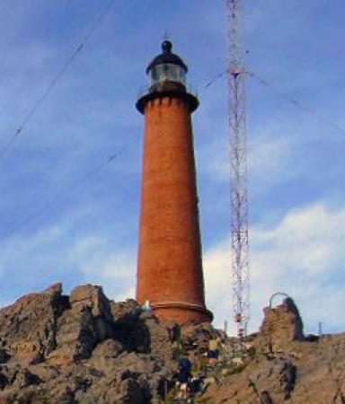
1917. Active; focal plane 67 m (220 ft); five long (1.5 s) white flashes every 40 s. 27 m (88 ft) round red brick tower with lantern and gallery, unpainted; lantern and gallery painted black. A photo is at right, Martin Irib has a 2017 closeup, Douglas Fernandes has a 2007 photo, Barbara Macia has a 2008 distant view, ARLHS has an aerial view, and Google has a street view and a good satellite view. This is a staffed station with a 1-story station building and several communications towers. The area surrounding the lighthouse is a nature reserve, the Reserva Natural Cabo Blanco. Located on a rocky headland at the end of provincial route 91 about 90 km (55 mi) north of Puerto Deseado; 4WD recommended. Site open, tower closed. ARLHS ARG-001; SHN 1370; Admiralty G1134; NGA 19912.
Punta Guzmán
1928. Active; focal plane 33 m (108 ft); two white flashes every 12 s. 17 m (56 ft) square pyramidal steel skeletal tower. Tower painted black; slatted daymark painted with an orange triangle. ARLHS has a photo and Bing has an indistinct satellite view. Lantern removed by 1971. Located in a remote area about 15 km (10 mi) south of Cabo Blanco. Site open, tower closed. ARLHS ARG-039; SHN 1372; Admiralty G1136; NGA 19916.

Cabo Blanco Light, Puerto Deseado
Patagonia.com photo
courtesy of Dir. de Turismo de Pto. Deseado
* Beauvoir (Puerto Deseado)
1980. Active; focal plane 48 m (157 ft); three white flashes every 10 s. Light mounted in the 28 m (92 ft) tower of the church of Nuestra Señora de la Guardia, the one tall structure on the skyline of Puerto Deseado. Trabas has Hendrik Martin Porath's photo, ARLHS has a photo, Russo has a photo, Michael Texis has a photo, and Google has a street view and a satellite view. The light is named for the priest José María Beauvoir, who explored the region and studied the native Patagonian cultures and languages between 1881 and 1924. Puerto Deseado ("Desired Port") is a fishing port of about 15,000 residents. It is named in Spanish for the ship Desire of the English privateer Thomas Cavendish, who was here in 1586. Located in downtown Puerto Deseado. Site and church open; it is not known if the tower is open for climbing. . ARLHS ARG-020; Admiralty G1139; NGA 19920.
* [Estación (Puerto Deseado Outer Range Front) (2)]
Date unknown. Active; focal plane 27 m (89 ft); quick-flashing white light. 19 m (62 ft) steel post; the top of the tower carries a slatted daymark painted black with an orange vertical stripe. Google has a street view and a satellite view. NGA formerly listed a truncated skeletal tower for this light. Located on the north side of the harbor entrance. Site open, tower closed. Admiralty G1140; NGA 19924.
* [Alonso (Puerto Deseado Outer Range Rear)]
Date unknown. Active; focal plane 40 m (131 ft); red light, 1 s on, 1 s off. 23 m (75 ft) steel post; the top of the tower carries daymark panels colored black with an orange vertical stripe. Trabas has Hendrik Martin Porath's photo, Agustina Paez has a 2018 distant view, and Google has a street view and a satellite view. Located on the waterfront 852 m (0.53 mi) west northwest of the front light. Site open, tower closed. Admiralty G1140.1; NGA 19928.
Roca Magallanes (Puerto Deseado Inner Range Front)
Date unknown. Active; focal plane 11 m (36 ft); red flash every 2 s. 12 m (39 ft) round barbell-shaped red fiberglass tower mounted on a platform supported by piles. Roberto Iza Dürr has a 2022 photo, Trabas has Hendrik Martin Porath's photo, and Google has a distant satellite view. Located on a rocky shoal in the Río Deseado southwest of the city's waterfront. Accessible only by boat. Site open, tower closed. Admiralty G1146; NGA 19932.
Las Barrancas (Puerto Deseado Inner Range Rear)
Date unknown. Active; focal plane 16.5 m (54 ft); white flash every 3 s. 9 m (30 ft) square pyramidal skeltal tower carrying a rectangular daymark colored red with a white vertical stripe. Roberto Iza Dürr has a 2022 photo and Google has an indistinct satellite view. Located at the northern tip of the Isla del Rey, a large island on the south side of the Río Deseado, 1.23 km (3/4 mi) west of the front light. Accessible only by boat. Site open, tower closed. Admiralty G1146.1; NGA 19936.
Isla Pingüino
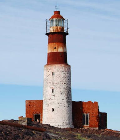
1903. Active; focal plane 60 m (197 ft); two white flashes, separated by 5 s, every 15 s. 22 m (72 ft) 2-stage round tower, with lantern and gallery, in two sections; the upper half is cast iron the lower half is masonry. Lower half painted white, upper half red with a white horizontal band; lantern painted red. 1-story brick keeper's quarters, abandoned since at least 1983, now in ruins. A photo is at right, Claudia Fujarra has a 2019 photo, Paolo Vallese has a 2022 photo, Trabas has Hendrik Martin Porath's photo, Rodrigo Pinedo has a 2009 photo, Huelse has a historic postcard view, and Google has a satellite view. This historic lighthouse is in poor condition and is clearly endangered. The island is a nature reserve, the Parque interjurisdiccional marino Isla Pingüino, protecting a large colony of southern rockhopper penguins. Located on an island off Cabo Mírador, about 18 km (11 mi) southeast of Puerto Deseado. Accessible only by boat or helicopter. Site open, tower closed. . ARLHS ARG-010; Admiralty G1152; NGA 19940.
[Punta Azopardo]
Date unknown. Active; focal plane unknown; white flash every 7 s. 5 m (16 ft) square skeletal tower painted black. Wikimedia has a photo and Google has a distant satellite view. This small beacon marks a rugged cape about 25 km (15 mi) south of Puerto Deseado. Site open but not easy to reach, tower closed. Admiralty G1153; NGA 19944.
Faro de la Isla Pingüino
Isla Pingüino Light, April 2008
ex-Panoramio photo copyright El Guanaco Volado
used by permission
Punta Medanosa
1949. Active; focal plane 29 m (95 ft); two white flashes, separated by 3 s, every 11 s. 12 m (39 ft) square pyramidal concrete skeletal tower, painted white, with black and white slatted daymark. Lantern removed. A photo is at right, Russo has a photo, Lotfi Si Saber has a 2018 photo, ARLHS has a photo, and Google has a satellite view. The surrounding area is a nature preserve, the Área de Vida Silvestre Punta Medanosa, known for its colonies of Magellanic penguins. Located on a rocky point off the end of provincial route 85 about 55 km (35 mi) south of Puerto Deseado. Accessible by 4WD (local guidance recommended). Site open, tower closed. ARLHS ARG-054; SHN 1402; Admiralty G1154; NGA 19948.
Cabo Guardián
1928 (rebuilt 1975). Active; focal plane 48 m (157 ft); flash every 7.5 s, alternating red and white. 36 m (118 ft) square pyramidal steel tower with lantern and gallery; enclosed inside is the original skeletal tower. Entire lighthouse painted black. Russo has a photo, ARLHS has a photo, Franco Martinez has a very distant view, and Google has a satellite view. Located on a prominent and steep headland about 160 km (100 mi) southwest of Puerto Deseado. There does not appear to be any road access to the site. Site open, tower closed. ARLHS ARG-027; SHN 1403; Admiralty G1156; NGA 19952.
Campana (Punta Mercedes) (2)
1975 (station established 1928). Active; focal plane 50 m (164 ft); two flashes, white and then red, every 16 s. 26 m (85 ft) square pyramidal steel tower, painted black. 1-story keeper's quarters, abandoned. Ruins of the original skeletal tower lie next to the present tower. ARLHS has a closeup, Russo has a photo, and Google has a satellite view. Located on Punta Mercedes, a remote headland about 175 km (110 mi) southwest of Puerto Deseado. There is no road access to the site. Site open, tower closed. ARLHS ARG-033; SHN 1404; Admiralty G1158; NGA 19956.


Punta Medanosa Light, Puerto Deseado, January 2011
Wikimedia Creative Commons photo by Mikelzubi


Magallanes Department (Puerto San Julián Area) Lighthouses
Cabo Dañoso
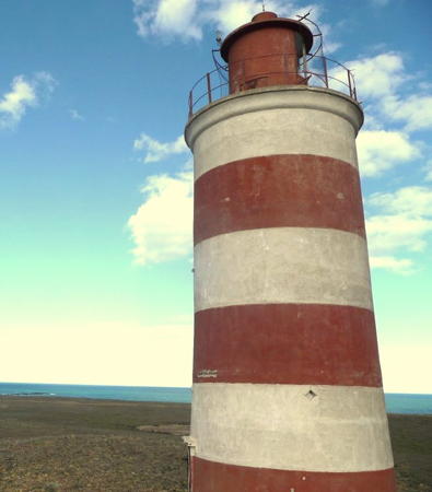
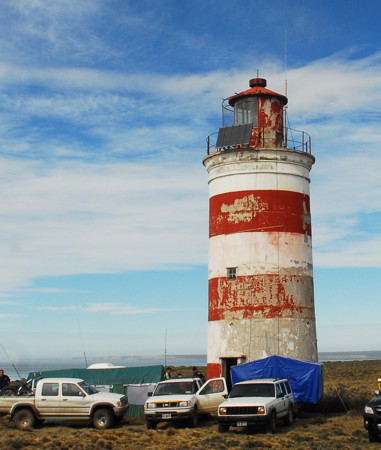
1947. Active; focal plane 44 m (144 ft); four white flashes, separated by 5 s, every 45 s. 12 m (39 ft) round cylindrical concrete tower with lantern and gallery, painted with red and white horizontal bands; lantern is red. SHN's photo is at the top of this page, Francisco Restu has a 2009 closeup, and Google has a good satellite view. Located on the point of the cape about 65 km (40 mi) northeast of Puerto San Julián. There does not appear to be any road access to the site. Site open, tower closed. ARLHS ARG-025; SHN 1405; Admiralty G1160; NGA 19960.
* Cabo Curioso
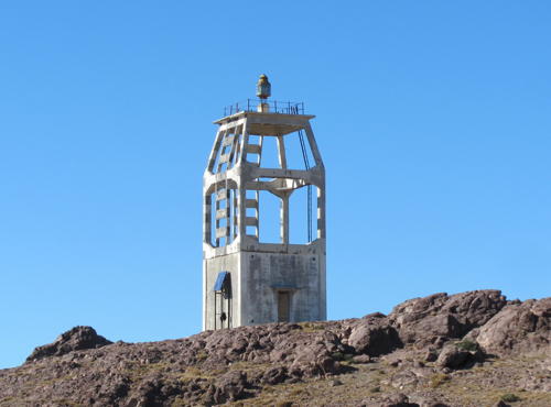
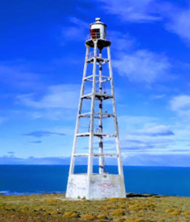
1922. Active; focal plane 92 m (302 ft); three long (1.5 s) flashes, separated by 9 s, every 45 s. 23 m (75 ft) square pyramidal concrete skeletal tower with lantern and gallery, painted white with a broad black band in the center; lantern is black. 1-story enclosed workroom in the base of the tower. A photo is at right, Ivan Carrillo has a 2019 photo, Christian Legare has a 2011 closeup photo, and Google has a good satellite view. This unusual and historic lighthouse is located about 20 km (13 mi) northeast of Puerto San Julián, marking the entrance to the harbor of the city. Site open, tower closed. . ARLHS ARG-024; SHN 1406; Admiralty G1162; NGA 19964.
Puerto San Julián Fourth Range Front
Date unknown. Active; focal plane 15 m (49 ft); white flash every 2 s. 16 m (52 ft) tower painted with red and white horizontal bands. No photo available but Bing has a satellite view. This range guides vessels approaching Puerto San Julián through a winding estuary, the Bahía San Julián. Located on the east side of the San Julián estuary about 3 km (2 mi) northeast of the town. Accessible only by boat. Site open, tower closed. Admiralty G1178; NGA 19992.
* #Justicia Alta (Puerto San Julián Fourth Range Rear) (1)
Date unknown. Active; focal plane 33 m (108 ft); white or red light, depending on direction, 2.5 s on, 2.5 s off. This was a 21 m (69 ft) square pyramidal skeletal tower, mounted on four concrete piles. The tower has been replaced by a triangular skeletal mast. Google has a street view and Bing has a satellite view. Located on the west side of the San Julián estuary on the south side of Puerto San Julián. Site status unknown, but it must be possible to view the tower (if it still stands) from nearby. Admiralty G1178.1; NGA 19996.
* Caldera Alta (Puerto San Julián Fifth Range Rear)
Date unknown. Active; focal plane 33 m (108 ft); red flash every 3 s. Approx. 25 m (82 ft) square pyramidal skeletal tower. Lighthouse painted black. At the top, the tower carries a slatted daymark painted yellow. A 2007 photo is available and the shadow of the tower is seen in a Google satellite view. This range guides vessels departing Puerto San Julián. Located on a hillside east of the Bahía San Julián, about 7 km (4 mi) northeast of Puerto San Julián. Accessible by 4WD. Site open, tower closed. Admiralty G1184.1; NGA 20004.
Faro Cabo Curioso
Cabo Curioso Light, April 2012
Flickr photo copyright fitob1; used by permission

Corpen Aike Department (Puerto Santa Cruz Area) Lighthouses
Cabo San Francisco de Paula
1917. Active; focal plane 86 m (282 ft); two white flashes, separated by 6 s, every 15 s. 8.5 m (28 ft) octagonal cylindrical skeletal tower with lantern and gallery; there is a small square equipment room enclosed within the base of the tower. Entire lighthouse painted black. ARLHS has a photo, and Google has a satellite view. Located on the "cape," a barely noticeable bend in the coastline about halfway between Puerto San Julián and Puerto Santa Cruz. There is a road to the light, but the site is quite remote. Site open, tower closed. ARLHS ARG-060; SHN 1430; Admiralty G1196; NGA 20016.
Punta Quilla Mole Elbow
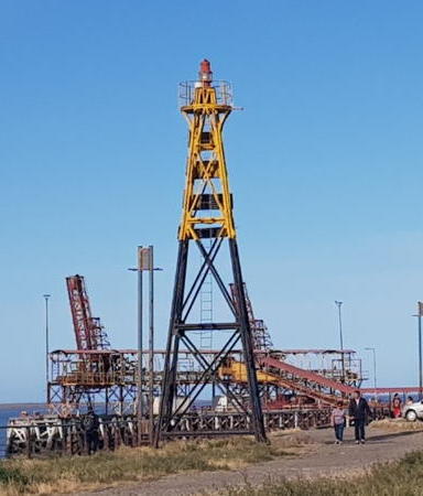
Date unknown. Active; focal plane 17 m (56 ft); red flash every 5 s. 13 m (43 ft) red mast mounted on a square 2-story building. A photo is available, Juan Manuel Pan has a view from the shore, and Google has a satellite view. Located on the pier at the Punta Quilla terminal on the south side of the Río Santa Cruz. Site status unknown. Admiralty G1211.2; NGA 20044.
Puerto Santa Cruz Canal Sur Range Front
Date unknown. Active; focal plane 17 m (56 ft); quick-flashing white light. 8.5 m (28 ft) round barbell-shaped fiberglass tower colored with black and white horizontal bands. No photo available but Google has a satellite view. This is an entrance range for ships approaching Puerto Santa Cruz from the south. Located on the north side of the entrance to the Río Santa Cruz. Site open, tower closed. Admiralty G1208; NGA 20032.
Puerto Santa Cruz Canal Sur Range Rear
Date unknown. Active; focal plane 35 m (115 ft); white flash every 3 s. 30 m (98 ft) square skeletal tower. No photo available but Google has an indistinct satellite view. Located 2.12 km (1.3 mi) north of the front light. Site status unknown. Admiralty G1208.1; NGA 20036.
Santa Cruz Canal Norte Entrada (Range Rear)
Date unknown. Active; focal plane 127 m (417 ft); white flash every 3 s. 12 m (39 ft) square black skeletal tower. Sebastian Benedetti has a distant view and Bing has an indistinct satellite view. This is an entrance range for Puerto Santa Cruz. Located on a high bluff on the south side of the Río Santa Cruz 1830 m (1.14 mi) west of the common front light. Site status unknown. Admiralty G1209.9; NGA 20028.
Santa Cruz Entrada Canal Norte Baja (Common Range Front)
Date unknown. Active; focal plane 34 m (112 ft); quick-flashing white light. 26 m (85 ft) square skeletal tower, painted with red and white horizontal bands. No photo available but Google has a satellite view. Located on the south side of the entrance to the Río Santa Cruz. Site open, tower closed. Admiralty G1210; NGA 20024.
Santa Cruz (Outbound Range Rear)
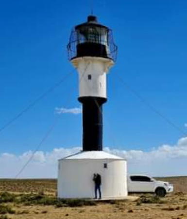
1923. Active; focal plane 157 m (515 ft); four long (1.5 s) white flashes, separated by 5 s, every 60 s. 12 m (39 ft) slender round cylindrical metal (cast iron?) tower with lantern and gallery, rising from the center of a small workroom. Lighthouse painted with black and white horizontal bands. Guy wires steady the tower. An SHN photo is at right, ARLHS has the same photo, Ale López has a 2019 fuzzy closeup, and Google has a satellite view. This is the departure range for Puerto Santa Cruz. Located about 20 km (13 mi) southeast of Puerto Santa Cruz, on the south side of the entrance to the Río Santa Cruz. Site open, tower closed. ARLHS ARG-066; SHN 1442; Admiralty G1210.1; NGA 20020.

Santa Cruz Light, Puerto Santa Cruz, February 2023
Santa Cruz Province photo

Güer Aike Department Lighthouses
Río Coig
1948. Active; focal plane 78 m (256 ft); two long (1.1 s) white flashes every 25 s. 11 m (36 ft) round cylindrical concrete tower with lantern and gallery, painted with red and white horizontal bands; lantern is red. Sibling of Faro Cabo Dañoso. A photo by Pipo Lopez is at right, ARLHS has a photo, and Google has a satellite view. Located on the north side of the entrance to the Río Coig, east of Puerto Coig and about 175 km (110 mi) north of Río Gallegos. There does not appear to be any road access to the site. Site open, tower closed. ARLHS ARG-035; SHN 1460; Admiralty G1222; NGA 20068.
* Cabo Buen Tiempo (Cape Fairweather)
1917. Active; focal plane 113 m (371 ft); four long (1.5 s) white flashes, separated by 5 s, every 45 s. 9 m (29 ft) octagonal cylindrical skeletal tower with lantern and gallery; there is a small square equipment room enclosed within the base of the tower. Entire lighthouse painted black. Francisco Restu has a closeup photo, ARLHS has a photo, and Google has a satellite view. This light has the same design as the Cabo San Francisco de Paula Light (see above). Located on the cape at the end of provincial route 55 on the north side of the entrance to the Río Gallegos. Site open, tower closed. ARLHS ARG-022; SHN 1461; Admiralty G1226; NGA 20072.
Isla Deseada (Río Gallegos Canal Norte Range Front)
Date unknown. Active; focal plane 18 m (59 ft); quick-flashing white light. 18 m (59 ft) square tower mounted on a platform supported by piles. No photo available but Google has a satellite view. The Río Gallegos estuary is complicated and requires numerous range lights. Located just off the south side of Isla Deseada, a small island in the mouth of the Río Gallegos. Accessible only by boat. Site open, tower closed. Admiralty G1236.
Rivera (Common Range Rear)
Date unknown. Active; focal plane 34 m (112 ft); red light occulting once every 3 s. Approx. 25 m (82 ft) square pyramidal skeletal tower. No photo available but Google has a satellite view. This is a middle light for the Canal Norte Range and for a second range guiding vessels departing Río Gallegos. Located on the north side of the estuary about 8 km (5 mi) west of the mouth. Site status unknown. Admiralty G1243.1.
Viento (Río Gallegos Canal Norte Range Rear)
Date unknown. Active; focal plane 34 m (112 ft); red light occulting once every 3 s. Approx. 15 m (49 ft) square skeletal tower. No photo available but Google has a satellite view. Located atop a steep bluff on the north side of the estuary about 8 km (5 mi) west of the Isla Deseada light. Site status unknown. Admiralty G1235.8.
Faro Río Coig
Río Coig Light, Puerto Coig, February 2011
ex-Panoramio photo copyright Pipo Lopez; used by permission
Gancho (Range Front)
Date unknown. Active; focal plane about 20 m (66 ft); light characteristic unknown. Approx. 15 m (49 ft) tower. No photo available but Google has an indistinct satellite view. This range guides vessels leaving the Río Gallegos docks. The Rivera light is the rear light. Located on the north side of the river opposite the city. Site status unknown. Admiralty G1243.
* Reducción (Río Gallegos West Range Front)
Date unknown. Active; focal plane about 11 m (36 ft); light characteristic unknown. Approx. 9 m (30 ft) square pyramidal skeletal tower painted black. Pablo Castricini has contributed a photo (upper left on the page), Richard Barrio has a photo and Google has a street view and a satellite view. The capital of Santa Cruz Province, Río Gallegos has a population of about 100,000. The range guides vessels arriving in Río Gallegos. Located on the city's waterfront just west of the piers. Site appears open, tower closed. Admiralty G1242.
* Güer Aike (Río Gallegos West Range Rear)
Date unknown. Active; focal plane about 30 m (98 ft); light characteristic unknown. Approx. 25 m (82 ft) square pyramidal skeletal tower painted black. Pablo Castricini has contributed a photo (upper right on the page) and Google has a street view and a satellite view. Located on the Avenida Ramón Carrillo about 2.5 km (1.5 mi) west of the front light. Site open, tower closed. Admiralty G1242.1.
Petroleo (Puerto Gallegos Second Range Rear)
Date unknown. Active; focal plane 37 m (121 ft); white light occulting once every 3 s. Approx. 22 m (72 ft) skeletal tower carrying a slatted daymark. Pablo Castricini has contributed a photo (lower left on the page) and Google has a satellite view. The front light is on a short skeletal tower seen in a Bing satellite view. Located on heights about 1.2 km (3/4 mi) south southwest of Punta Loyola. Site status unknown. Admiralty G1231.1.
Punta Loyola Range Front
Date unknown. Active; focal plane about 14 m (46 ft); red light, characteristic unknown. 10 m (33 ft) square skeletal tower with black and yellow daymark panels. Juan Marcelo Britos has a January 2018 photo, and Google has a satellite view. This range guides eastbound (departing) vessels. Located at Punta Loyola, a promontory on the south side of the entrance to the estuary and the location of a terminal shipping iron ore. Site status unknown. Admiralty G1241.
Punta Loyola Range Rear
Date unknown. Active; focal plane about 30 m (98 ft); white light, characteristic unknown. Approx. 22 m (72 ft) square skeletal tower. Pablo Castricini has contributed a photo (lower right on the page), Aaron Montiel has a closeup photo, and Google has a satellite view. Located on the east side of Punta Loyola. Site status unknown. Admiralty G1241.1.
Banco (Puerto Gallegos First Range Front)
Date unknown. Active; focal plane 13.5 m (44 ft); red light occulting once every 2 s. Approx. 10 m (33 ft) skeletal tower carrying a large daymark colored with red and white horizontal bands. No photo available but Google has a satellite view. Located near the coast about 5 km (3 mi) south of Punta Loyola. Site status unknown. Admiralty G1230.
Pozos (Puerto Gallegos First Range Rear)
Date unknown. Active; focal plane 23.5 m (77 ft); white light occulting once every 3 s. Approx. 15 m (49 ft) skeletal tower carrying a large daymark colored with red and white horizontal bands. No photo available but Bing has a satellite view. Located about 1.5 km (1 mi) southwest of the front light. Site status unknown. Admiralty G1230.1.
* Cabo Vírgenes
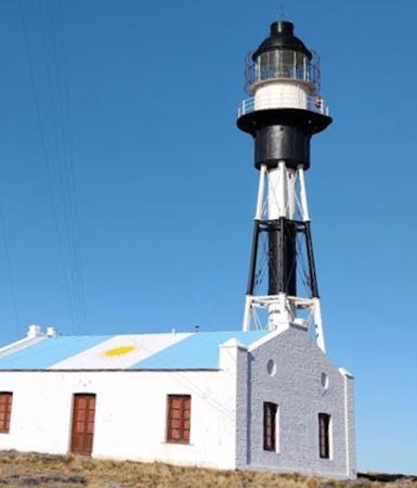
1904. Active; focal plane 69.5 m (228 ft); white flash every 5 s. 26 m (85 ft) hexagonal pyramidal skeletal tower with central cylinder, lantern and gallery; Fresnel lens in use. Lighthouse painted with black and white horizontal bands. Jaquelina Castro's photo is at right, Horacio Fernandez has a photo, Felicitas Molina has a good photo, Mario Edgardo Merino has a 2017 photo, Trabas has Silvano's photo, and Google has a good satellite view. This historic lighthouse marks the eastern entrance to the Strait of Magellan, along with the Chilean lighthouse at Punta Dungeness (see the Chile: Magallanes page) about 10 km (6 mi) to the southwest. This is an active naval station. Nearby is a penguin sanctuary with a visitor center. As of 2004 the lighthouse was in rather poor condition and there was concern about its preservation. However, it appears in recent photos that the lighthouse has been refurbished and repainted. Located near the end of provincial route 1 about 80 miles (unpaved) south of Río Gallegos. Site open, tower closed. . ARLHS ARG-032; SHN 1492; Admiralty G1260; NGA 20152.

Cabo Virgenes Light, Strait of Magellan, February 2021
Google Maps photo
by Jaquelina Castro

Information available on lost lighthouses:

Notable faux lighthouses:

Adjoining pages: North: Río Negro and Chubut | East: Falkland Islands | South: Tierra del Fuego

Return to the Lighthouse Directory index | Ratings key

Posted December 2003. Checked and revised July 11, 2023. Lighthouses: 39. Site copyright 2023 Russ Rowlett and the University of North Carolina at Chapel Hill.