Lighthouses of Argentina: Tierra del Fuego

Argentina (officially the Argentine Republic, República Argentina) is the second largest country of South America and has a population approaching 50 million. Located on the southern east coast of the continent, Argentina has a lengthy coastline on the South Atlantic Ocean, extending from the warm waters of the Río de la Plata to the edge of the cold Southern Ocean.

Colonized by Spain in the mid 1500s, Argentina secured its independence and territorial integrity in series of uprisings between 1810 and 18i6. Several decades of controversy and conflict established the organization of the country and its borders with its neighbors to the north. Between 1878 and 1884 Argentina expanded its control southward, occupying the region of Patagonia east of the Andes Mountains.

Argentina is a federation of 23 provinces (provincias) plus the autonomous capital city of Buenos Aires. This page includes lighthouses of the southernmost part of the country, the islands of Tierra del Fuego. Separated from the mainland by the Strait of Magellan, Tierra del Fuego was claimed by both Argentina and Chile. Under the Boundary Treaty of 1881 the main island was divided between the two countries along the longitude line of 68°34' W while the smaller islands to the south were assigned to Chile. An effect of the treaty is that the entire Strait of Magellan, including its eastern entrance, is in Chile; this leaves a gap in the Argentine coastline at the Strait entrance.

Most visitors to Argentine Tierra del Fuego arrive by air or cruise ship, but it is possible to drive to the island, crossing the Strait by ferry at Punta Delgada, Chile. National Route 3, a paved highway, extends to Ushuaia on the south coast overlooking the Beagle Channel.

Argentine Tierra del Fuego is part of the province known as Tierra del Fuego, Antártida e Islas del Atlántico Sur; officially the province includes the Falkland Islands, South Georgia, the South Sandwich Islands, and the wedge-shaped slice of Antarctica claimed by Argentina. The three island groups are all occupied by Britain and territorial claims in Antarctica are suspended indefinitely by the Antarctic Treaty. The Tierra del Fuego portion of the province is divided into three districts called departments (departamentos).

The Spanish word for a lighthouse is faro; smaller lighthouses are often called balizas (beacons). In Spanish isla is an island, cabo is a cape, punta is a promontory or point of land, péñon is a rock, arrecife is a reef, bahía is a bay, ría is an estuary or inlet, estrecho is a strait, río is a river, and puerto is a port or harbor.

Active lighthouses in Argentina are owned by the Argentine Navy and managed by the Navy's Servicio de Hidrografía Naval (SHN).

ARLHS numbers are from the ARLHS World List of Lights. SHN numbers, where available from Spanish Wikipedia, are from the Argentine light list, Faros y Señales Marítimas. Admiralty numbers are from volume G of the Admiralty List of Lights & Fog Signals. U.S. NGA List numbers are from Publication 110, except that lights of the Beagle Channel are from Publication 111. The official Argentine light list, Faros y Señales Marítimas, is not available online.

General Sources
Lista de Faros Argentinos
Official SHN lighthouse site, with data and small photos. Unfortunately, it is not possible to link directly to the pages for individual lighthouses.
Faros de Argentina
Index to lighthouse articles and photos in the Spanish Wikipedia.
Faros Argentinos
Information and photos from the Argentine-based Faros del Mar website.
Lighthouses in Argentina
The ARLHS listing of Argentine lights; the society has photos for most of them.
Faros Argentina
Photos posted on Flickr.com by Carlos María Silvano.
Online List of Lights - Argentina
Photos by various photographers posted by Alexander Trabas. Many of the Tierra del Fuego photos are by Hendrick Martin Porath or Jim Smith.
World of Lighthouses - Argentina
Photos by various photographers available from Lightphotos.net.
Lighthouses in Argentina
Photos available from Wikimedia.
GPSNauticalCharts
Navigational chart for Argentine Tierra del Fuego.
Navionics Charts
Navigational chart for Argentine Tierra del Fuego.

Faro San Sebastián
San Sebastián Light, Tierra del Fuego
unattributed photo from farosdelmundo.com.ar
(no longer online)

Río Grande Department Lighthouses

Río Grande is a city of about 70,000 residents on the east coast of Tierra del Fuego. Tax incentives have encouraged its industrial development and it has become a center for electronics manufacture.

Atlantic Coast Tierra del Fuego Lighthouses
* Magallanes
1976. Active; focal plane 53 m (174 ft); three white flashes every 50 s. 13.5 m (44 ft) square skeletal tower with gallery, painted black. The upper portion of the tower is partially enclosed by a slatted daymark painted in black and yellow bands. ARLHS has a photo and Google has a street view and a satellite view. Located 800 m (1/2 mi) southeast of the border between Chile and Argentina south of the Strait of Magellan. Accessible by road (4WD recommended). Site open, tower closed. ARLHS ARG-043; Admiralty G1260.5; NGA 20156.
Punta Páramo (2?)
1924. Active; focal plane 22.5 m (74 ft); white flash every 7.5 s. 17.5 m (57 ft) square pyramidal steel skeletal tower with lantern and gallery, painted black. Francisco Berola has a good photo (also seen at right) and Google has a satellite view. Located near the end of the Península El Páramo, a long sand spit partially enclosing the Bahía de San Sebastián. Accessible only by boat or a long 4WD drive on the beach. Site open, tower closed. ARLHS ARG-057; Admiralty G1261; NGA 20160.
[Bahía de San Sebastián Range Front]
Date unknown. Active; focal plane and light characteristic unknown. Tall skeletal mast. No photo available but Bing has a satellite view. This is an entrance range. Located on a headland on the south shore of the Bahía de San Sebastián about 10 km (6 mi) east of the town of San Sebastián. Site status unknown. Admiralty G1265.
[Bahía de San Sebastián Range Rear]
Date unknown. Active; focal plane and light characteristic unknown. Tall skeletal mast. Google has a distant street view and a satellite view. Located off highway 3 about 2.5 km (1.5 mi) southeast of the town of San Sebastián and about 4 km (2.5 mi) west of the front light. Site status unknown. Admiralty G1265.1.

Punta Páramo Light, Tierra del Fuego, May 2004
Google Maps photo by Francisco Berola
Proel Range Front
Date unknown. Active; focal plane and light characteristic unknown. Tall square skeletal tower. No photo available but Bing has a satellite view. This range guides outnound vessels across the Bahía de San Sebastián but it's not clear where they would be coming from. Located on the south shore of the Bahía de San Sebastián about 10 km (6 mi) west of the San Sebastián lighthouse. Site status unknown. Admiralty G1263.4.
Proel Range Rear
Date unknown. Active; focal plane and light characteristic unknown. Tall square skeletal tower. No photo available but Bing has a satellite view. Located about 3 km (1.8 mi) southeast of the front light. Site status unknown. Admiralty G1263.6.
* San Sebastián
1949. Active; focal plane 60 m (197 ft); three white flashes, separated by 5 s, every 40 s. 11 m (36 ft) round cylindrical concrete tower with lantern and gallery. Lighthouse painted with blue and yellow spiral bands; lantern painted black. A photo is at the top of this page, Marcelo Baiz has a 2022 photo, Pedro Motoa has a 2018 closeup photo, Wikimedia has a 2014 sunrise photo, and Google has a good satellite view. Located off national route 3 about 25 km (16 mi) east of the town of San Sebastián, marking the southern entrance to the Bahía de San Sebastián. Accessible by road (4WD recommended). Site open, tower closed. ARLHS ARG-013; Admiralty G1262; NGA 20192.
[Cabo Domingo]
1933. Active; focal plane 90 m (295 ft); white light, 2 s on, 6 s off. 6 m (20 ft) triangular skeletal tower; two sides are covered by a slatted daymark painted white with a black horizontal band. Ramondaniel Ledesma has a photo, Trabas has Porath's photo, and Bing has a satellite view. The area is a nature reserve. Located atop a steep bluff (an unusual high point on an otherwise flat coast) about 15 km (9 mi) northwest of Río Grande. Accessible by hiking from national route 3. Site open, tower closed. ARLHS ARG-026; Admiralty G1266; NGA 20196.
* Río Grande Second Range Front
Date unknown. Active; focal plane 26 m (85 ft); green flash every 2 s. 16 m (52 ft) square skeletal tower, pianted black and carrying a slatted daymark showing a red diamond on a white background. Trabas has Porath's photo and Google has a street view and a satellite view. Located on Comodoro Luis Py street in downtown Río Grande. Site open, tower closed. Admiralty G1269; NGA 20216.
* Río Grande Second Range Rear
Date unknown. Active; focal plane 37 m (121 ft); white light, 1 s on, 1 s off. Light mounted atop a commerical building. Google has a street view and a satellite view. Located on the Avenida Manuel Belgrano just north the Avenida San Martín in Río Grande. Site open, tower closed. Admiralty G1269.1; NGA 20220.
* Río Grande Third Range Rear
Date unknown. Active; focal plane 22 m (72 ft); white light, 1.5 s on, 1.5 s off. 18 m (59 ft) square skeletal tower carrying a slatted daymark painted with black and yellow horizontal bands. Trabas has Porath's closeup photo and Google has a street view and a satellite view. The front light is on a 7 m (23 ft) tower with a daymark of red and white horizontal bands. Located on the Avenida 11 de Julio near the intersection with the Avenida Padre Beauvoir in Río Grande. Site open, tower closed. Admiralty G1270.1; NGA 20228.
* Río Grande Fourth Range Rear
Date unknown. Active; focal plane 11 m (36 ft); green (?) light, 2.5 s on, 2.5 s off. 9 m (30 ft) square skeletal tower carrying a slatted daymark painted with orange and black horizontal bands. Trabas has Porath's closeup photo and Google has a street view and a satellite view. The front light is on a short mast. Located on the waterfront on the south side of Río Grande. Site open, tower closed. Admiralty G1271.1; NGA 20236.
Cabo Peñas
1916. Active; focal plane 42 m (138 ft); two white flashes, separated by 5 s, every 20 s. 13 m (42 ft) square pyramidal steel skeletal tower with lantern and gallery, painted black. Daniel Cueto's photo is at right, Faros Argentinos has a page for the lighthouse with a 2011 photo, and Bing has a satellite view. Located on a headland about 10 km (6 mi) southeast of Río Grande. Site open, tower closed. ARLHS ARG-028; Admiralty G1274; NGA 20256.

Cabo Peñas Light, Tierra del Fuego, September 2019
Google Maps photo by Daniel Cueto
Cabo San Pablo (1)
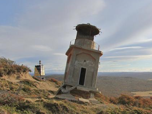
1945. Inactive since 1949. 6 m (20 ft) square cylindrical concrete tower with lantern and gallery. After being in service only four years the lighthouse was heavily damaged by the earthquake of 17 December 1949. The quake left the tower leaning at an angle of about 30°. A photo is at right, Rogerio Tomazela has a closeup, Carlos Guédez has a 2022 photo, Braian Mellor has a street view, and Google has a satellite view. Located at the end of provincial route A off national route 3 about 80 km (50 mi) southeast of Río Grande. Site open, tower closed. ARLHS ARG-031..
Cabo San Pablo (2)
1966. Active; focal plane 136.5 m (448 ft); two white flashes every 20 s. 6 m (20 ft) square pyramidal steel skeletal tower with a slatted rectangular black and yellow daymark. Javier Salva has a closeup photo, Susana Peralta has a photo, and Google has a satellite view. Located close to the historic lighthouse. Site open, tower closed. ARLHS ARG-074; Admiralty G1275; NGA 20260.

Ushuaia Department Lighthouses

Isla de los Estados Lighthouses
The Isla de los Estados (Staten Island) is a mountainous island off the southeastern tip of Tierra del Fuego. The island is about 65 km (40 mi) long and roughly 15 km (9 mi) wide, with a rugged and deeply indented coastline. It is separated from Tierra del Fuego by the 30 km (19 mi) wide Strait of Le Maire. The entire island is set aside as a provincial ecological preserve, and the only settlement is a small naval station staffed by rotating crews. Adventure tours to the island are available from Ushuaia.

Cabo San Pablo Lights, Tierra del Fuego
unattributed ex-Google Maps photo
Le Maire (Cabo Galeano) (2)
1993 (station established 1926). Active; focal plane 47 m (154 ft); three white flashes every 32 s. 4 m (13 ft) round hourglass-shaped fiberglass tower; upper half yellow and lower half black. SHN has a photo and Bing has a distant satellite view. Located on a promontory at the west end of the Isla los Estados. Accessible only by boat. Site open, tower closed. ARLHS ARG-042; Admiralty G1280; NGA 20272.
Año Nuevo (Isla Observatorio)
1902 (Barbier & Bernard). Active; focal plane 65.5 m (215 ft); three white flashes, separated by 8 s, every 32 s. 23.5 m (77 ft) round cast iron tower with lantern and double gallery, in two sections, the upper half narrower than the lower. Federico Alvarez has a 2017 photo (also seen at right), Wikimedia has Abel Sberna's photo, Ariel Osvaldo Pierucci has a distant view, and Google has a satellite view. Sibling of Faro Isla Pengüino (see Santa Cruz). Built with British support in connection with Antarctic expeditions, this light station has been declared a national historic monument. The abandoned 1-story building adjacent to the tower formerly housed a meteorological and geophysical observatory. The observatory was staffed continuously from 1902 to 1919, contributing greatly to scientific knowledge of the southern oceans. Endangered: the lighthouse is in poor condition and the other buildings are crumbling. Studies were in progress to determine how best to restore the site. Located on the Isla Observatorio, a small island off the north coast of the Isla de los Estados. Accessible only by boat. Site and tower closed. ARLHS ARG-003; Admiralty G1279; NGA 20268.
San Juan de Salvamento (replica 2)
1998 replica of 1884 lighthouse. Active; focal plane 72.5 m (238 ft); two white flashes, separated by 3 s, every 15 s. 6.5 m (21 ft) octagonal frame keeper's quarters, the light shown through a square window. The building is painted white and crowned by a gray metal globe. ARLHS has a photo, and Google has a nice photo and a good satellite view. Wikimedia has a 2008 photo of the present lighthouse and an 1898 photo of the original lighthouse. Argentina's oldest lighthouse was replaced by the Faro Año Nuevo in 1902, but not before it played the starring role in the Jules Verne novel Le Phare du Bout du Monde (The Lighthouse at the End of the World). In 1998 a society of French Jules Verne fans worked with the Argentine Navy to rebuild the historic building. However, the new structure is octagonal; the original was 12-sided and there are other noticeable differences. The same society built another copy (also octagonal) off the Pointe des Minimes at La Rochelle on France's Charente coast. Remains and artifacts of the original lighthouse are on display at the Museo Maritimo de Ushuaia along with another (and somewhat more faithful) replica. Located high on a cliff near the northeastern end of the Isla de los Estados, marking the entrance to a sheltered cove that is one of few safe anchorages at the island. Accessible only by boat in famously tumultuous seas. Site and tower closed. ARLHS ARG-002; Admiralty G1283; NGA 20269.

Año Nuevo Light, Isla de los Estados, June 2017
Google Maps photo by Federico Alvarez

Southeast Coast Tierra del Fuego Lighthouses
Cabo San Diego
1934. Active; focal plane 40 m (131 ft); three white flashes, separated by 3 s, every 32 s. 14 m (43 ft) square cylindrical concrete skeletal tower with lantern. Tower unpainted, lantern painted black. Ricardo Gramajo has a 2020 photo (also seen at right) and Bing has a satellite view. Fresnel lens in use. In the photos the lighthouse appears weathered and in need of repairs. This lighthouse marks the extreme southeast corner of Tierra del Fuego and the west side of the northern entrance to the Strait of Le Maire. Accessible only by boat. Site and tower closed. ARLHS ARG-030; Admiralty G1276; NGA 20264.
[Martins López]
Date unknown. Active; focal plane 10 m (33 ft); white flash every 5 s. 7 m (23 ft) triangular skeletal tower painted red with a white horizontal band. No photo available but Google has a satellite view. The light guides vessels into a harbor of refuge sheltered by the cape of Buen Suceso midway on the west side of the Strait of Le Maire. Accessible only by boat. Site and tower closed. Admiralty G1278; NGA 20288.
[Buen Suceso (4?)]
1985(?) (station established 1916). Active; focal plane 57 m (187 ft); two white flashes every 16 s. 5 m (16 ft) post painted with red and white horizontal bands. Bing has a satellite view. NGA lists a skeletal tower. SHN says the light was solarized in 1985 and probably the skeletal tower was replaced by the post at that time. Located on a sharp promontory on the west side of the Strait of Le Maire. Accessible only by boat. Site and tower closed. ARLHS ARG-021; Admiralty G1277; NGA 20284.

Cabo San Diego Light, Tierra del Fuego, February 2020
Google Maps photo by Ricardo Gramajo
[San Gonzalo (Punta Kinnaird) (3)]
2003 (station established 1928). Active; focal plane 38 m (125 ft); white flash every 10 s. 4 m (13 ft) fiberglass post colored green with one white horizontal band. Wikimapia has a photo and Bing has a satellite view. The original light was a cylindrical round tower, probably brick. Severely deteriorated, it was replaced in 1970 by a 7 m (23 ft) square pyramidal skeletal tower. That tower also deteriorated in the severe weather of the area, so it was replaced by the present light in 2003. Located on Punta Kinnaird, marking the west side of the entrance to the sheltered anchorage of Bahía Aguirre. Site status unknown. ARLHS ARG-061; Admiralty G1288; NGA 110-20300.

Beagle Channel Lighthouses
(see also Southern Chile)
The Beagle Channel (Canal de Beagle) is the narrow strait separating the mainland (Isla Grande) of Tierra del Fuego from an archipelago of smaller islands to the south. The channel is named for HMS Beagle, the survey ship that carried Charles Darwin on its round the world expedition in the late 1820s. The strait is about 240 km (150 mi) long and as little as 5 km (3 mi) wide. The eastern half of the channel is the border between Argentina (on the mainland side) and Chile (on the south side); the western half is entirely in Chile. The only Argentine town is Ushuaia, the southernmost city in the world. Adventure cruise ships often visit Ushuaia, making this remote passage familiar to many tourists. Wikipedia has a useful map of the channel.

Cabo San Pío
1919. Active; focal plane 55 m (180 ft); two white flashes, separated by 4.5 s, every 16 s. 8 m (26 ft) round brick tower with lantern and gallery, the lower part cylindrical and the upper part conical, painted with red and white horizontal bands. A closeup photo is at right, Irene Lucia Sanabria Ramirez has a closeup photo, Lucas Anibaldi has a 2021 photo, a page for the lighthouse has several photos, Trabas has Erich Hartmann's view from the sea, and Bing has a satellite view. With an unusual design the lighthouse looks like a giant bowling pin. Access to the gallery and lantern is by an exterior ladder. This lighthouse marks the southernmost point of Argentine Tierra del Fuego and the entrance to the Beagle Channel. Islands on the south side of the channel are in Chile. Accessible only by boat. Site open, tower closed. ARLHS ARG-065; Admiralty G1292; NGA 110-20304.
Punta Moat
Date unknown. Active; focal plane not listed; white flash every 8 s. 12 m (39 ft) square skeletal tower carrying a daymark planted with black and yellow horizontal bands. Most of the daymark is missing in a 2012 photo by Fabián Lippolis and all of it is gone in Porath's photo posted by Trabas. The tower is not seen in Bing's indistinct satellite view. Located on the north side of the Channel marking the entrance to the Paso Moat, the passage between the mainland and Chile's Isla Picton. Accessible only by boat. Site open, tower closed. Admiralty G1296; NGA 111-2710.12.
Davison
Date unknown. Active; focal plane 8 m (26 ft); two white flashes (separated by 4 s) every 16 s. 7 m (23 ft) square pyramidal concrete skeletal tower enclosing a square equipment shed and carrying a daymark painted with red and white horizontal bands. George Naxera has a closeup photo, Emmanuel Dovis has a closeup street view, and Bing has only an indistinct satellite view. Located on the north side of the Channel opposite Isla Picton. Accessible by route J, an unpaved road that follows the shore. Site open, tower closed. Admiralty G1300; NGA 111-2710.07.

Cabo San Pio Light, Tierra del Fuego, New Year's Day 2013
Wikimedia Creative Commons photo by Latitud 55 Sur - Pelicula
Pampa de los Indios
Date unknown. Active; focal plane about 25 m (82 ft); white flash every 5 s. 6 m (20 ft) (?) round cylindrical concrete tower painted with black and white horizontal bands and topped by a sqaure skeletal mast. The mast appears to have increased the total height to about 10 m (33 ft). Trabas has Porath's photo, Fabián Lippolis has a photo and Bing has a distant satellite view. Located on a promontory about 10 km (6 mi) west of the Davison light. Accessible only by boat. Site open, tower closed. Admiralty G1304; NGA 111-2710.02.
Ponsati
Date unknown. Active; focal plane 9 m (39 ft); two white flashes every 16 s. 7 m (23 ft) square pyramidal skeletal tower enclosed by a slatted daymark painted with black and white horizontal bands. Trabas has Smith's photo seen at right and Bing has a satellite view.Located on a promontory about 10 km (6 mi) west of the Pampa de los Indios light. Accessible only by boat. Site open, tower closed. Admiralty G1306; NGA 111-2708.
Isla Martillo
Date unknown. Active; focal plane 7.5 m (25 ft); white flash every 7 s. 7.5 m (25 ft) square pyramidal concrete skeletal tower mounted on a square 1-story concrete equipment shelter. Lighthouse painted red with a white horizontal band. Trabas has a photo by Thomas Philipp and Google has a distant satellite view. Located at the southeast end of Isla Martillo a tadpole-shaped island east of the larger Isla Gable. Accessible only by boat. Site open, tower closed. Admiralty G1308; NGA 111-2700.
Punta Mackinlay
Date unknown. Active; focal plane 9.5 m (31 ft); red flash every 2 s. 7 m (23 ft) barbell-shaped fiberglass tower, colored in a red and white checkerboard pattern. Trabas has Erich Hartmann's photo, a 2021 photo also shows hundreds of penguins, and Google has a distant satellite view. This light marks the southern tip of Isla Gable, a large island that nearly blocks the Beagle Channel. Accessible only by boat. Site open, tower closed. ARLHS ARG-116; Admiralty G1310; NGA 111-2696.

Ponsati Light, Beagle Channel, February 2020
photo copyright Jim Smith; used by permission
Punta Espora
Date unknown. Active; focal plane 16 m (52 ft); white flash every 4 s. 8 m (26 ft) hourglass-shaped fiberglass tower, colored with red and white horizontal bands. Trabas has Erich Hartmann's photo, and Google has a distant satellite view. This light marks the southern tip of Isla Gable, a large island that nearly blocks the Beagle Channel. Accessible only by boat. Site open, tower closed. Admiralty G1311; NGA 111-2684.
Isla Gable Range Front
Date unknown. Active; focal plane 48 m (157 ft); white flash every 5 s. 6 m (20 ft) square pyramidal skeletal tower with a red slatted daymark. Trabas has Thomas Philipp's photo and Google has an indistinct satellite view. This range guides vessels eastbound in the Beagle Channel, departing Ushuaia. Isla Gable is a large island on the north side of the Channel. Located atop a steep bluff at the west end of the island. Site status unknown. Admiralty G1314; NGA 111-2668.
Isla Gable Range Rear
Date unknown. Active; focal plane 72 m (236 ft); white flash every 4 s. 8 m (26 ft) square pyramidal skeletal tower with a white slatted daymark. Trabas has Thomas Philipp's photo and Bing has an indistinct satellite view. This range guides vessels eastbound in the Beagle Channel, departing Ushuaia. Located 353 m (0.22 mi) east of the front light. Site status unknown. Admiralty G1314.1; NGA 111-2672.
Dirección
Date unknown. Active; focal plane 24 m (79 ft); two white flashes every 16 s. 7 m (23 ft) barbell-shaped fiberglass tower, colored red with a yellow horizontal band. Trabas has Thomas Philipp's view from the channel and Google has an indistinct satellite view. Located on the mainland opposite the west end of Isla Gable. Accessible only by boat. Site open, tower closed. Admiralty G1315; NGA 111-2664.

Ushuaia Area Lighthouses
Ushuaia, the capital of Argentine Tierra del Fuego, is usually regarded as the southernmost city in the world. Founded in the 1880s, the city has a population today of nearly 75,000. Thousands of tourists visit the city every year as part of cruises to the Antarctic region.

Rocas Lawrence
Active; focal plane 9 m (30 ft); six very quick white flashes followed by one long white flash. 9 m (30 ft) square pyramidal solid concrete tower, upper half painted yellow and lower half black. Trabas has Thomas Philipp's photo and Bing has a distant satellite view. Located on a rocky reef on the north side of the channel. Accessible only by boat. Site open, tower closed. Admiralty G1318; NGA 111-2632.
#Punta San Juan (1)
Active; focal plane 24 m (79 ft); white flash every 8 s. This was an 8 m (26 ft) square pyramidal skeletal tower, painted with red and white bands. It has been replaced by a slender skeletal mast with a daymark colored white with a red horizontal band. Ruins of the original tower lie below the new light as seen in Jim Smith's photo at right; Trabas also has Smith's photo. The tower casts a long shadow downslope in Google's satellite view. Located on the north side of the Beagle Channel about 16 km (10 mi) east of Ushuaia. ARLHS ARG-086 (=082). Active light: Admiralty G1319.4; NGA 111-2624.

Punta San Juan Light, Beagle Channel, February 2020
photo copyright Jim Smith; used by permission
Islotes les Éclaireurs
1920. Active; focal plane 22.5 m (74 ft); white flash every 10 s. 11 m (36 ft) round brick tower with lantern and gallery, painted red with a broad white horizontal band; lantern is black. Wikimedia has numerous photos including Liam Quinn's photo at right, Trabas has Erich Hartmann's closeup photo, Neal Doan has photos, Antonio Diaz has a photo, a 2008 photo is available, and Bing has a satellite view. In fact, this is one of the most photographed of all Argentine lighthouses. Tour operators often call it the End of the World lighthouse (el faro del fin del mundo), although it is the Faro San Juan de Salvamento that earned that nickname (see above). The proper name Islotes les Éclaireurs is borrowed-French for "Islets of the Scouts." Located in the Beagle Channel marking the approach to Ushuaia. Cruises and ecotours often pass or visit this site. Site open, tower closed. ARLHS ARG-016; Admiralty G1320; NGA 111-2620.
* Escarpados (Playa Larga)
Active; focal plane 59 m (194 ft); white flash every 10 s. 10 m (33 ft) square pyramidal skeletal tower, painted black. The tower carries a slatted daymark painted with black and yellow bands. Trabas has Eckhard Meyer's closeup photo, Bastian von Jarzebowski has a street view, Vicente Martin Arbo's street view takes in the spectacular surroundings, and Bing has a satellite view. Located on the east side of the entrance to the Bahía Ushuaia. Accessible by a road (provincial route 30) that ends at this site. Site open, tower closed. ARLHS ARG-085; Admiralty G1323.6; NGA 111-2616.
Punta Observatorio
Active; focal plane 10 m (33 ft); white flash every 2 s. 8 m (26 ft) square pyramidal skeletal tower, covered with a slatted daymark painted with red and white bands. Trabas has Erich Hartmann's closeup photo, and Google has a satellite view. Located on the south side of the entrance to Ushuaia harbor from the Beagle Channel. Visible easily from cruise ships entering Ushuaia. ARLHS ARG-080; Admiralty G1325; NGA 111-2580.
San Juan de Salvamento (replica 1)
1997 replica of 1884 lighthouse. Inactive. 7 m (23 ft) 12-sided frame keeper's house with a opyramidal roof topped by a gray gobe ornament. Sides painted white, roof red. A closeup photo is available, Wikimedia has Jorge Gobbi's photo, and Google has a satellite view. This replica was built after archeological research at the original site on the Isla de los Estados (see above). It is 12-sided like the original, differing from the octagonal 1998 replica built near that site. Located at the Museo Maritime de Ushuaia, on the east end of the town. Site and tower open (admission fee). Owner/site manager: Museo Maritimo de Ushuaia.
Les Éclaireurs Light
Les Éclaireurs Light, Ushuaia, January 2011
Wikimedia Creative Commons photo
by Liam Quinn
Zeballos (2)
Active; focal plane 13 m (42 ft); white flash every 4 s. 12 m (39 ft) round barbell-shaped fiberglass tower, painted red with white bands. Trabas has Jim Smith's photo seen at right and Bing has an indistinct satellite view. This light has replaced a similar tower 8 m (26 ft) tall previously listed by NGA and seen in a 2007 photo by Tony Galvez. Located on the north side of the Beagle Channel, marking the border between Argentina and Chile. ARLHS ARG-087; Admiralty G1329.5; NGA 111-2570.

Information available on lost lighthouses:

Notable faux lighthouses:

Adjoining pages: North: Santa Cruz | South: Antarctica | West: Chile Magallanes


Punta San Juan Light, Beagle Channel, 2011
photo copyright Jim Smith; used by permission

Return to the Lighthouse Directory index | Ratings key

Posted December 2003. Checked and revised July 18, 2023. Lighthouses: 34. Site copyright 2023 Russ Rowlett and the University of North Carolina at Chapel Hill.