Lighthouses of Mexico: Northwestern Baja California

Mexico, officially the United Mexican States (Estados Unidos Mexicanos or EUM), is the second largest country of Latin America and the largest Spanish-speaking nation in the world. With an east coast on the Gulf of Mexico and Caribbean Sea and a long west coast on the Pacific Ocean it has by far the longest coastline in Latin America and, as a result, the largest number of lighthouses.

The Baja California region of Mexico is a peninsula more than 1300 km (800 miles) long, stretching south from the U.S. border at Tijuana to the resorts of Cabo San Lucas. "Baja," as it is usually called, separates the Pacific on the west from the Sea of Cortés (Gulf of California) on the east. The west coast is popular with surfers and the east coast attracts sea kayakers and ecotourists. Many visitors arrive in Baja California by air or cruise ship, but there are also paved highways running the length of the peninsula. Federal Highway 1, the Carretera Transpeninsular, runs 1711 km (1063 mi) from Tijuana at the U.S. border to Cabo San Lucas

Mexico is a federal union of 31 states (estados) plus the capital district, and the states are subdivided into municipalities (municipios). This page includes the lighthouses of the west coast of the state of Baja California, which occupies the northern half of the peninsula. The state of Baja California Sur occupies the southern half, the border between the two states being at latitude 28° north. The largest cities, Tijuana and Mexicali, are in the far north close to the U.S. border.

Many of the lighthouses of Baja California are in remote areas and are seldom visited. Additional information and photos would certainly be welcome. Because of the rugged topography of the peninsula, most of the lighthouses are short towers located at the tops of bluffs or ridges overlooking the sea.

Mexican lighthouses are managed by the Port Captains and Maritime Affairs Unit (Unidad de Capitanías de Puerto y Asuntos Marítimos, UNICAPAM). Many of the larger light stations are staffed by resident civilian keepers.

In Spanish the word for a lighthouse is faro, baliza is a beacon, isla is an island, cabo is a cape, punta is a promontory or point of land, péñon is a rock, arrecife is a reef, bahía is a bay, ría is an estuary or inlet, estrecho is a strait, río is a river, and puerto is a port or harbor.

ARLHS numbers are from the ARLHS World List of Lights. CF numbers are from the Mexican Cuaderno de Faros (Handbook of Lighthouses). Admiralty numbers are from volume G of the Admiralty List of Lights & Fog Signals. All U.S. NGA numbers are from Publication 111.

General Sources
Online List of Lights - Mexico Pacific
Photos by various photographers posted by Alexander Trabas.
Lighthouses in Mexico
Photos by various photographers available from Wikimedia.
Viaje por las Islas del Pacífico de Baja California
Posted by Elizabeth Vargas, a blog of a March 2009 tour of some of the islands, with stops at several remote lighthouses.
World of Lighthouses - Mexico
Photos by various photographers available from Lightphotos.net.
Navionics Charts
Navigational chart for Baja California.
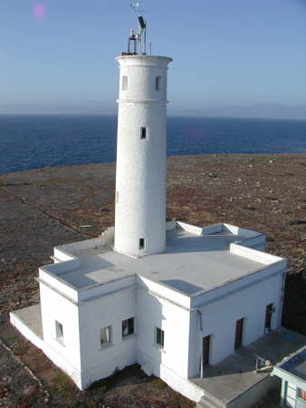

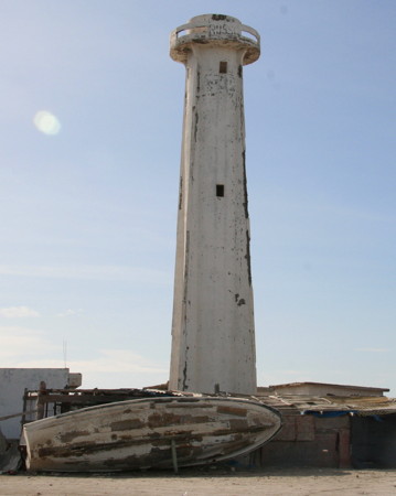
First lighthouse, Islas de Todos Santos, June 2007
Flickr Creative Commons photo by Leonardo Galicia
Isla Cedros and Islas San Benito Lighthouses
Isla Cedros is a large island in the Pacific Ocean about 100 km (62 mi) off the coast of Baja California. About 38 km (24 mi) long and 17 km (11 mi) wide, the mountainous island has a population of about 1300. The island is administered as a borough of Ensenada Municipality, even though it is quite remote from Ensenada since the creation of the San Quintín Municipality in 2020.

Punta del Morro Redondo (2)
Date unknown. Active; focal plane 22 m (72 ft) (?); white flash every 6 s. Approx. 15 m (49 ft) square pyramidal skeletal tower with gallery, painted white. Gibran Rodriguez has a 2022 drone view and Google has a satellite view. This light replaced an 8.5 m (28 ft) tower. This has probably increased the focal plane height to about 28 m (92 ft). Located at the southern tip of Isla Cedros, on a hill above the island's airport. Site and tower probably closed, but the lighthouse is easy to see from the airport. CF-02-180; Admiralty G3609; NGA 14452.
[Punta San Agustin]
Date unknown. Active; focal plane 20 m (66 ft);m three white flashes every 12 s. 6 m (20 ft) square pyramidal skeletal tower with gallery, painted white. The Cuaderno has a small photo and Gogle has a satellite view. Located on a bluff near the western tip of Isla Cedros. Site open but remote, tower closed. CF-02-180.1; Admiralty G3608.
Isla Cedros (Punta Norte)
Date unknown. Active; focal plane 11 m (36 ft); four white flashes every 16 s. 6.5 m (21 ft) square pyramidal concrete tower with gallery. Entire lighthouse is white. Vargas has a small photo and a report on a March 2009 visit and Google has a satellite view. Located near the northern point of Isla Cedros. Accessible only by boat. Site open, tower closed. CF-02-165; Admiralty G3611.8; NGA 14448.
Isla Los Benitos Punta Sur
Date unknown. Active; focal plane 53 m (174 ft); white flash every 6 s. 4 m (13 ft) round white concrete tower. The Cuaderno de Faros has a small photo and Google has a satellite view. The Islas San Benito is a group of three small islands about 25 km (15 mi) west of Isla Cedros. Home to numerous birds and elephant seals, the islands are a popular destination for ecotours. There is a small settlement at the east end of the westernmost and largest island, the Isla Los Benitos, northwest of Isla Cedros and about 80 km (50 mi) west of the Baja California peninsula. Located on the southern tip of the Isla San Benitos. Accessible only by boat. Site open. CF-02-185.2; Admiralty G3612; NGA 14416.
Islas San Benito (1)
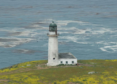
1934. Inactive since 2009 at least. 17 m (56 ft) white concrete tower with lantern and gallery attached to a 1-story keeper's house; the lantern dome is gray metallic. A photo is at right, Philip Colla has a photo, a ecotour company has another photo, and Google has a satellite view. Ecotours to the island often visit the lighthouse. Located at the western end of the Isla San Benitos, about 2 km (1.25 mi) west of the settlement. Accessible only by boat. Site open, tower closed. ARLHS MEX-071.
Islas San Benito (2)
2009 (station established 1934). Active; focal plane 212 m (696); three white flashes every 20 s. 7 m (23 ft) square concrete tower with lantern and gallery, painted white. Elizabeth Vargas has a small photo and a report on a March 2009 visit Google has a satellite view. Located at the highest point of the Isla San Benitos about 400 m (1/4 mi) southeast of the older lighthouse. Site open, tower closed. CF-02-185; Admiralty G3613; NGA 14412.
Faro Islas San Benito
1934 Islas San Benito Light, December 2007
ex-Panoramio photo by cedropolis

Isla de Guadalupe Lighthouses
The Isla de Guadalupe is a volcanic island located far out in the Pacific, 240 km (150 mi) west of Baja California. The island is about 35 km (22 mi) long and 9 km (5.5 mi) wide. There is no permanent population but several small fishing camps are occupied most of the year. The island also has an airstrip. Administratively the island is attached to the San Quintín Municipality.

Isla de Guadalupe Norte
Date unknown. Active; focal plane 14 m (46 ft); two white flashes every 10 s. 12 m (39 ft) square pyramidal skeletal tower with gallery, painted white. Trabas has Capt. Peter Mosselberger's fuzzy photo and Google has a satellite view. This lighthouse is located at the anchorage on the northeastern coast of the island. Site open, tower closed. Admiralty CF-02-130; G3613.6; NGA 14401.
Isla de Guadalupe Sud
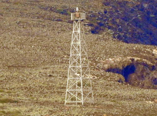
Date unknown. Active; focal plane 38 m (125 ft); three white flashes every 12 s. 12 m (39 ft) square pyramidal skeletal tower with gallery, painted white. Trabas has Capt. Peter Mosselberger's photo (also seen at right) and Google has a satellite view. Located at the southern tip of the island. Site open, tower closed. CF-02-135; Admiralty G3613.7; NGA 14402.
Isla de Guadalupe Oeste
Date unknown. Active; focal plane 48 m (157 ft); four white flashes every 16 s. 12 m (39 ft) square pyramidal skeletal tower with gallery, painted white. Trabas has Capt. Peter Mosselberger's photo and Google has a satellite view. This is Mexico's westernmost lighthouse. Located on a prominent cape on the southwestern side of the island. Site open, tower closed. CF-02-140; Admiralty G3613.5; NGA 14400.

Isla Guadalupe Sud Light
photo copyright Capt. Peter Mosselberger; used by permission

San Quintín Municipality West Coast Lighthouses
The Ensenada Municipality formerly included all of the Pacific coast of Baja California state south of the Tijuana area. The San Quintín Municipality was separated from Ensenada Municipality in February 2020. The municipality includes more than 1000 km (620 mi) of coastline between the southern border of the state and Vicente Guerrero.
* Guerrero Negro (Puerto Venustiano Carranza, Laguna Ojo de Liebre)
Date unknown (around 1960?). Inactive since the 1970s. Approx. 16 m (52 ft) round cylindrical concrete tower with gallery and four ribs. Entire lighthouse painted white. Lantern removed, as seen in Jeanne Strayer's photo at right. Charles Bash has an older (2004?) photo (#MX 78, 1/4 the way down the page) showing the tower with the lantern intact. Francisco Castellón has a 2018 photo, Stefan Köstler has a distant view, Luis Pulido has a street view, and Google has a satellite view. This lighthouse guided ships arriving to load salt at the Laguna Ojo de Liebre, also called Scammon's Lagoon. It seems to have had only a short active life, being replaced by a series of range lights on wooden posts marking the twisting entrance. Located at the wharf of the salt works, about 13 km (8 mi) northwest of Guerrero Negro and about 5 km (3 mi) north of the border of Baja California Sur. Site open, tower closed.
Morro Santo Domingo
Date unknown. Active; focal plane 38 m (125 ft); four white flashes every 16 s. 10 m (33 ft) round cylindrical white concrete tower with gallery. Marie Getz has a photo, Antonio Lopez Navarro has a closeup photo and Google has a satellite view. Located on a remote headland at the northern entrance to the Bahía de Sebastián Vizcaíno, which lies between the mainland and Isla Cedros. Probably accessible only by boat. Site open, tower closed. ARLHS MEX-160; CF-02-160; Admiralty G3615; NGA 14409.
Punta Negra (Punta Prieta, El Marrón)
Date unknown. Active; focal plane 16 m (52 ft); three white flashes every 12 s. 10 m (33 ft) round cylindrical white concrete tower with gallery. Google has a distant satellite view. A 2018 photo by Enrique Villaseñor Estrada (no longer online) showed the tower leaning and in poor condition. Located on a remote headland near El Marrón. Probably accessible only by boat. Site open, tower closed. ARLHS MEX-164; CF-02-155; Admiralty G3615.3; NGA 14408.
Punta Blanca
Date unknown. Active; focal plane 25 m (82 ft); two white flashes every 10 s. 7 m (23 ft) square pyramidal skeletal tower. No photo available but Google has a distant satellite view. Located on a remote headland about 40 km (25 mi) north of Punta Negra. Site status unknown. CF-02-150; Admiralty G3615.4; NGA 14405.
Isla San Jerónimo
Date unknown. Active; focal plane 47 m (154 ft); two white flashes every 10 s. 6 m (20 ft) hexagonal tower with lantern and gallery, attached to a small 1-story masonry equipment room. Lighthouse painted white, lantern roof painted red. Solar-powered lens. Armando Olachea Castro has a closeup 2018 photo, Leticia Ortega Gutierrez also has a photo, and Google has a satellite view. Located at the summit of the island about 8 km (5 mi) northwest of San Antonio. Accessible only by boat. Site open, tower closed. ARLHS MEX-108; CF-02-125; Admiralty G3616; NGA 14396.
Faro de Guerrero Negro
Guerrero Negro Light, Guerrero Negro, February 2007
ex-Panoramio photo copyright Jeanne Strayer; used by permission
* Punta Baja
Date unknown. Active; focal plane 17 m (56 ft); four white flashes every 16 s. 10 m (33 ft) square pyramidal skeletal tower with gallery. Trabas has a photo by Hendrik Martin Porath, another closeup photo is available, Vargas has a small photo and a report on a March 2009 visit, and Google has an indistinct satellite view. This tower was either replaced or raised in height; it was formerly listed with a height of 8 m (26 ft). Punta Baja is a sharp promontory pointing southward about 16 km (10 mi) south of El Rosario. Accessible by 4WD vehicles. Located on the tip of the cape. Site open, tower closed. CF-02-120; Admiralty G3616.4; NGA 14394.
* Punta Azufre
Date unknown. Active; focal plane 12 m (39 ft); three white flashes every 10 s. 10 m (33 ft) square pyramidal skeletal tower with gallery. Roy Mar has a closeup photo and Google has a distant satellite view. Located on a point on the east side of the entrance to the Bahía San Quintin. Accessible by 4WD. Site open, tower closed. CF-02-110; Admiralty G3617; NGA 14392.
Isla San Martín
Date unknown. Active; focal plane 49 m (161 ft); two white flashes every 12 s. 10.5 m (34 ft) square pyramidal skeletal tower with gallery. No photo available but the tower casts a shadow in Google's too-bright satellite view. Isla San Martín is a small volcanic island about 6.5 km (4 mi) off the coast near San Martín. Located atop a cliff on the southwest side of the island. Accessible only by boat. Site status unknown. CF-02-105; Admiralty G3618; NGA 14388.

Ensenada Municipality Lighthouses
Punta Colonet (Cabo Colonet)
Date unknown. Active; focal plane 68 m (223 ft) (?); white flash every 6 s. 7 m (23 ft) square pyramidal skeletal tower. No photo available but Google has a satellite view. The Cuaderno lists the focal plane as 110 m (361 ft), a substantial discrepancy. NGA misspells the name as Cabo Colnet. Located on a prominent headland northwest of Vicente Guerrero.. Site status unknown but probably reachable by 4WD. CF-02-100; Admiralty G3619; NGA 14384.
* Punta San José
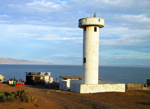
Date unknown. Active; focal plane 35 m (115 ft); four white flashes every 16 s. 10 m (33 ft) cylindrical white concrete tower with gallery; no lantern. A closeup photo is at right, Bobby Lee has a photo and Google has a satellite view. A site popular with surfers, Punta San José is about 40 km (25 mi) southwest of Santo Tomas by a dirt road. The lighthouse stands on a bluff overlooking the beach. Site open. ARLHS MEX-184; CF-02-095; Admiralty G3619.5; NGA 14380.

Punta San José Light, August 2014
Google Maps photo by Baja Scenario
* Punta Banda
Date unknown. Active; focal plane 15 m (49 ft); two white flashes every 10 s. 6 m (20 ft) square pyramidal masonry tower with gallery, painted white. Bill Wiederhold has a 2022 photo, Gabriel Salvador has an aerial view, and Google has a satellite view. Punta Banda is the tip of a long promontory on the south side of the Bahía de Ensenada, part of the same ridge that continues underwater to the Islas de Todos Santos. The cape is accessible by 4WD vehicles. Located at the end of the peninsula, about 16 km (10 mi) across the bay southeast of Ensenada. Site open, tower closed. CF-02-090; Admiralty G3622; NGA 14376.
Islas de Todos Santos Sur
Date unknown. Active; focal plane 31 m (102 ft); three white flashes every 12 s. 7 m (23 ft) round cylindrical white concrete tower with gallery. Luis Bersan has a 2023 photo, a view from the sea is available and Google has a satellite view. Located on the southern tip of the southern of the two islands of Todos Santos, located in the Bahía de Ensenada about 20 km (13 mi) west of Ensenada. The islands are well known as a surfing site. Accessible only by boat. Site open, tower closed. CF-02-085; Admiralty G3621; NGA 14368.
Islas de Todos Santos (1)
Date unknown. Inactive. Stone tower, about 14 m (45 ft tall), attached to a 1-story stone keeper's house. Lighthouse painted white. Lantern removed. The building was abandoned and deteriorating but recently it has been renovated and repainted. Leonardo Galicia's closeup photo is at the top of this page, a photo by Viktor Kampos is at right, the tower is at the left in Tomas Castelazo's aerial photo and in the background of Galicia's distant view, Sergio Pou has a 2016 photo of the two lighthouses, and Google has a satellite view showing both lighthouses. ARLHS MEX-109.
Islas de Todos Santos (2)
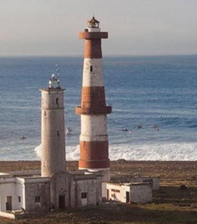
Date unknown. Active; focal plane 49 m (161 ft); white flash every 7 s. 30 m (98 ft) concrete tower with two galleries, lantern and gallery. Lighthouse painted with red and white horizontal bands. A small clamshell Fresnel lens is in use. A photo by Viktor Kampos is at right, Tomas Castelazo has an aerial photo, Leonardo Galicia has an extreme closeup and a distant view, Sergio Pou has a 2016 photo of the two lighthouses, and Google has a satellite view showing both lighthouses. The lighthouse is on the northwest tip of the northern of the two islands of Todos Santos. Accessible only by boat. Site open, tower closed. . ARLHS MEX-078; CF-02-080; Admiralty G3620; NGA 14364.

Old and new Islas de Todos Santos Lights, October 2021
Google Maps photo by Viktor Kampos

Ensenada City Lighthouses
Founded in 1542, Ensenada is a historic city of about 550,000 residents. The city is an important port, a site of several military bases, and a popular cruise ship stop. In Spanish ensenada is a cove, a small, sheltered harbor. The city takes its name from the Ensenada de Todos Santos, All Saints Bay in English, a cove partially sheltered by the Islas de Todos Santos and the cape of Punta Banda.

Ensenada East Breakwater Elbow
Date unknown. Active; focal plane 14 m (46 ft); red flash every 5 s. 13 m (43 ft) square pyramidal skeletal tower painted red. No photo available but Google has a satellite view. Located on the east side of the entrance to the harbor of Ensenada. Site and tower closed. CF-02-060; Admiralty G3626.2; NGA 14373.1.
Ensenada East Breakwater Pier
Date unknown. Active; focal plane 14.5 m (47 ft); red flash every 5 s. 13.5 m (44 ft) square pyramidal skeletal tower painted red. No photo available but Google has a satellite view. Located at the end of a broad pier attached to the east breakwater. Site and tower closed. CF-02-055.3; Admiralty G3626.21; NGA 14373.
Ensenada West Breakwater (2)
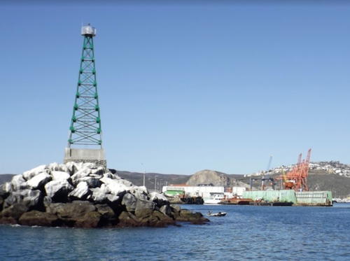
Date unknown. Active; focal plane 21 m (69 ft); green flash every 5 s. 17 m (56 ft) square pyramidal skeletal tower painted green. Gabriel Salvador has a 2015 photo (also seen at right) and Daniel Uribe has a view from the sea. The breakwater was extended 400 m (1/4 mi) in 2017-18 and the light was relocated to the end of the extension. Juan Carlos Nuñez has a 2021 photo of the relocated lighthouse and Bing has a satellite view. The earlier tower had a height of 12 m (39 ft). Located at the end of the main breakwater of Ensenada. Site and tower closed. CF-02-050; Admiralty G3626; NGA 14372.
Punta Morro (2?)
Date unknown. Active; focal plane 16 m (52 ft); white flash every 6 s. 6 m (20 ft) hexagonal cylindrical white concrete tower with gallery. Adan Mejia-Trejo has a 2019 aerial view and Google has a street view and a satellite view. A black post next to the lighthouse probably carried a former light. Located on a promontory in an industrial area about 4 km (2.5 mi) west of the Ensenada harbor. Site status unknown. CF-02-045; Admiralty G3629; NGA 14360.
El Sauzal North Breakwater (1)
Date unknown. Replaced. 8 m (26 ft) square pyramidal red skeletal tower. Trabas has Hendrik Martin Porath's photo, Baphomet Campos has a 2013 photo, and Google has a satellite view. The light has been moved to a red post (focal plane 10 m (33 ft); red flash every 5 s). Located on the outer elbow of the north breakwater (the Admiralty calls it the East Breakwater) of the El Sauzal harbor, an industrial harbor on the north side of Ensenada. Site and tower closed. Active light: CF-02-035; Admiralty G3629.5; NGA 14353.
El Sauzal Range Front
Date unknown. Inactive. Approx. 16 m (52 ft) square pyramidal skeletal tower painted with red and white horizontal bands (may have been repainted red in 2023 like the rear tower). The light is in the lower left corner of a photo by Rubén Velázquez and Google has a street view and a satellite view. This range guiding vessels into the El Sauzal harbor has been replaced by a leading light (next entry). Located beside Calle 12 in El Suazal. Site and tower closed but the tower is easy to see from the street. CF-02-025; ex-Admiralty G3629.4; NGA 14349.

West Breakwater Light, Ensenada, February 2015
Google Maps photo by Gabriel Salvador
El Sauzal Leading
Date unknown. Active; focal plane about 24 m (79 ft); light characteristics unknown. Light mounted atop a large building on the El Sauzel quay. Google has a street view and a satellite view. Site and tower closed but the light is easy to see from the street. Admiralty G3629.55.
El Sauzal Range Rear
Date unknown. Inactive. Approx. 21 m (69 ft) square pyramidal skeletal tower painted red (formerly painted with red and white horizontal bands). Mario Cruz has a 2023 photo and Google has a street view and a satellite view. The Cuaderno lists the focal plane as 16 m, but this must be a typo as the rear light is higher than the front light. Site and tower closed but the tower can be seen from the Camino La Instituto nearby. CF-02-025.1; ex-Admiralty G3629.41; NGA 14350.
El Sauzal South Breakwater (1)
Date unknown. Replaced. 8 m (26 ft) square pyramidal green skeletal tower. Trabas has Hendrik Martin Porath's photo and Bing has a satellite view. The light has been moved to a green post (focal plane 10 m (33 ft); green flash every 5 s). Located on the outer elbow of the south breakwater (the Admiralty calls it the West Breakwater) of the El Sauzal harbor. Site and tower closed. Active light: CF-02-030; Admiralty G3629.7; NGA 14355.
Punta San Miguel
Date unknown. Active; focal plane 51 m (167 ft); two white flashes every 10 s. 6 m (20 ft) round cylindrical white concrete tower. Google has a street view and a satellite view. Located atop a cliff close to the Highway 1 motorway about 8 km (5 mi) west of Ensenada. Site status unknown. CF-02-020; Admiralty G3630; NGA 14348.5.

Islas Coronados (Coronado Islands) Lighthouses
The Islas Coronados are a group of four rocky and barren islands about 14 km (8.5 mi) off the coast, 25 km (15 mi) southwest of Tijuana, and about 42 km (26 mi) southwest of San Diego, California. The islands are uninhabited except for the lighthouse keepers and a small military post. They are attached administratively to Tijuana City.

Islas Coronados Sur
Date unknown. Active; focal plane 48 m (157 ft); three white flashes every 12 s. 6 m (20 ft) round cylindrical white concrete tower with lantern and gallery. Lighthouse painted white, lantern red. A closeup photo is available, Airdrie Kincaid has a 2019 photo, and Bing has a satellite view. Located on a steep rocky bluff at the south end of South Coronado Island. Accessible only by boat. ARLHS MEX-112;CF-02-015; Admiralty G3635; NGA 14348.
Islas Coronados Norte (1)
Date unknown. Inactive. 6 m (20 ft) square white pyramidal concrete tower with a 1-story keeper's house. Airdrie Kincaid has a closeup photo, an aerial photo is available, and Google has a satellite view. Located on a ridge at the north end of South Coronado Island. Accessible only by boat. ARLHS MEX-111.
Islas Coronados Norte (2)
Date unknown. Active; focal plane 75 m (246 ft); two white flashes every 10 s. 10 m (33 ft) octagonal cylindrical white concrete tower with gallery. Airdrie Kincaid has a 2019 photo and Bing has a satellite view. Located high on the ridge above the older lighthouse. Accessible only by boat. ARLHS MEX-110; CF-02-010; Admiralty G3634; NGA 14344.

Tijuana City Lighthouse
Located adjacent to the U.S. border and close to the U.S. city of San Diego, Tijuana is one of México's largest cities with a population of about two million.

* Tijuana
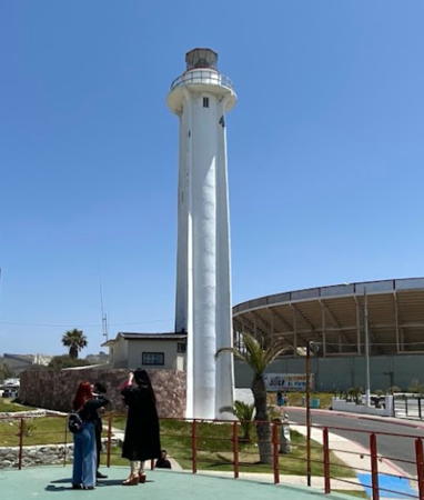
Date unknown. Active; focal plane 32 m (105 ft); white flash every 6 s. 22 m (72 ft) cylindrical white concrete tower, unpainted. Kyosuke Jin's 2022 photo is at right, Miguel Angel Sauceda has a December 2008 photo, Trabas has Jim Smith's view from the sea, and Google has a street view and a satellite view. The lighthouse was built fairly recently as part of a plan to develop Tijuana's beachfront. Located next to the beach just a few feet from the U.S. border and the "Bullring by the Sea" (Plaza Monumental de Tijuana), which is part of the same development. Site open, tower closed. . ARLHS MEX-083; CF-02-005; Admiralty G3635.5; NGA 14338.

Tijuana Light, Tijuana, May 2022
Google Maps photo by Kyosuke Jin

Information available on lost lighthouses:

Notable faux lighthouses:

Adjoining pages: North: Southern California | East: Northwest Coast | South: Southern Baja California

Return to the Lighthouse Directory index | Ratings key

Posted June 2002. Checked and revised December 6, 2023. Lighthouses: 36. Site copyright 2023 Russ Rowlett and the University of North Carolina at Chapel Hill.