Lighthouses of the United States: Southern California

The United States of America is a federal union of 50 states and a capital district. The west coast state of California is the most populous state in the nation with a population approaching 40 million. It is also the third largest state, with a coastline on the Pacific Ocean about 840 mi (1350 km) long.

Formerly a Mexican territory, California became part of the U.S. after the Mexican War of 1848. The famous Gold Rush began in 1849 and the first lighthouses were built a few years later. These early lights, like the Old Point Pinos Light shown below, were built in a what was then a typical New England style. Ironically there are no examples of this style surviving in New England, so the only place to see these traditional New England lighthouses is in California.

Southern California is not an administrative region but it is a rather well defined cultural region bounded conveniently on the north at latitude 35° 47' 28" North, a line forming the northern borders of San Luis Obispo, Kern, and San Bernardino Counties. This area represents the southern third of the state and includes the major cities of Los Angeles and San Diego. This page includes the lighthouses of the Southern California coast from the Mexican border north through San Luis Obispo County. Lighthouses of Northern California are on a separate page.

Navigational aids in the United States are operated by the U.S. Coast Guard but ownership (and sometimes operation) of historic lighthouses has been transferred to local authorities and preservation organizations in many cases. Aids to navigation in Southern California are maintained by the Eleventh Coast Guard District, which has Aids to Navigation Teams based at San Diego and Long Beach.

ARLHS numbers are from the ARLHS World List of Lights. Admiralty numbers are from volume G of the Admiralty List of Lights & Fog Signals. USCG numbers are from Vol. VI of the USCG Light List.

General Sources
California Lighthouses
An excellent site by Kraig Anderson, with information and photos on each of the light stations.
Online List of Lights - California
Photos by various photographers posted by Alexander Trabas.
California Lighthouses
Fine photos of 31 sites by Robert English.
California Lighthouses
A site by Ed Litfin, with very fine photos, maps, and visitor information.
Lighthouses of California
Collection of photos by Bryan Penberthy and Michael Jackman.
California, United States Lighthouses
Aerial photos posted by Marinas.com.
World of Lighthouses - California and Hawaii
Photos by various photographers available from Lightphotos.net.
Lighthouses in California
Photos by various photographers available from Wikimedia.
Leuchttürme USA auf historischen Postkarten
Historic postcard images posted by Klaus Huelse.
U.S. Coast Guard Navigation Center: Light Lists
The USCG Light List can be downloaded in pdf format.
NOAA Nautical Charts
Official nautical charts for the coast can be viewed online.
Navionics Charts
Navigation chart for California.


Point Vicente Light, Palos Verde, May 2011
Flickr Creative Commons photo by Tony Hoffarth


New Point Loma Light, San Diego, May 2023
Instagram photo by Anterior Photography

San Diego County Lighthouses
Located close to the Mexican border with a deepwater natural harbor, San Diego is an important port and a major base for the U.S. Navy and Marine Corps. The city has a population approaching 1.4 million and the county that includes it has a total opulation of more than 3.3 milion.

* Harbor Island (Tom Ham's Lighthouse)
1971. Active; focal plane 56 ft (17 m); white flash every 4 s. Approx. 50 ft (15 m) octagonal light tower with lantern and gallery rising from a 2-story restaurant building. Sarah Biggart has a 2009 closeup photo, Trabas has Douglas Cameron's photo, and Google has a street view and a good satellite view. The restaurant was renovated and restored in 2013. Located at the west end of Harbor Island in downtown San Diego. Site open, tower closed. ARLHS USA-1439; Admiralty G3702; USCG 6-1700.
* San Diego Entrance Range Rear (Shelter Island)
Date unknown. Active; focal plane 55 ft (17 m); green light, 3 s on, 3 s off. Approx. 50 ft (15 m) square skeletal tower. The tower carries a rectangular slatted daymark painted red with a white vertical stripe. Trabas has Douglas Cameron's photo and Google has a street view and a satellite view. The front light is on tripod pilings. Located at the western end of Shelter Island on the north side of San Diego Bay. Site open, tower closed. ARLHS USA-1440; Admiralty G3679.1; USCG 6-1505.
Point Loma (2) (New Point Loma)
1891. Active; focal plane 88 ft; white flash every 15 s. 70 ft (21 m) square pyramidal skeletal tower with central cylinder. Tower painted white, lantern and watch room black. Two 2-story wood Spanish revival keeper's houses, white with red roofs, are used as Coast Guard housing. The original 3rd order Fresnel lens, removed in 2002, is on display at the Old Point Loma Light keeper's quarters (next entry). Fog horn (blast every 30 s when needed) at base of the tower. A photo is at the top of this page, Erin and Lance Willett have a similar photo, English has a good closeup photo, Trabas has Jim Smith's photo, Marinas.com has aerial photos, Huelse has a historic postcard view, and Google has a street view and a satellite view. The only surviving tower of its type on the U.S. Pacific Coast, this lighthouse is a sibling of the Coney Island Light in New York. In 2001 the Coast Guard had a engineering firm studying the condition and future of the lighthouse. A new LED lamp was installed in February 2013. A restoration of the lighthouse began in September 2017 and was scheduled for six months, but crews quickly found the condition of the lighthouse but be much worse than expected. In fact the project lasted into 2021, cost $2.1 million, and included replacement of the lantern with a historically accurate replica. In August 2021 the Coast Guard held a rededication ceremony marking the completion of all restoration work. Located at the southernmost tip of Point Loma, marking the entrance to San Diego's harbor. Site and tower closed, but the lighthouse can be viewed from the parking area at Cabrillo National Monument. Owner/site manager: U.S. Coast Guard. (Station San Diego ). . ARLHS USA-626; Admiralty G3676; USCG 6-0005.
**** Point Loma (1) (Old Point Loma)
1855. Inactive since 1891 (lit decoratively; the light source is offset from the center of the lens so the light is of no navigational value). Charted as a landmark. 46 ft (14 m) round cylindrical brick tower with lantern and gallery rising from the roof of 1-1/2 story sandstone keeper's house. Tower and house painted white, lantern black, lantern dome red. The 3rd order Fresnel lens from the Miles Rocks Light, San Francisco, is mounted in the tower. Lighthouse painted white, lantern black. A photo is at right, Lighthouse Digest has Gene Wild's July 2005 article on the history of the lighthouse, Anderson has a great page, Zhou Zhaoliang has a photo, Wikimedia has many photos, a 2022 photo is available, Huelse has a historic postcard view, and Google has a closeup street view and a satellite view. This lighthouse had a focal plane of 462 ft (141 m), but this proved to be too high: the light was often obscured by low clouds or fog. The lighthouse was ordered demolished in 1913; it was saved by the decision to make the area a national monument. In June 2003 the lighthouse was closed for six months while the station was restored to its 1880s appearance. The assistant keeper's house was reconstructed to serve as a visitor center and museum; the 3rd order Fresnel lens from the 1891 lighthouse and the 4th order Fresnel lens from the Ballast Point lighthouse are on display. There was another restoration in 2018-19. Located at the end of CA 209 on Point Loma, at the western end of San Diego. Site open, lighthouse and tower open daily except Thanksgiving Day and Christmas Day. Owner: U.S. National Park Service. Site manager: Cabrillo National Monument. . ARLHS USA-627.
* [Ballast Point (1) (lantern)]
1890. Inactive since 1959. Lantern painted white with a red roof. A photo is available, Anderson has a page for the lighthouse, and Google has a street view and a satellite view. The 4th order lens from this lighthouse is displayed at Old Point Loma Light (see above). The Ballast Point lighthouse was a sibling of the San Luis Obispo lighthouse (see below). The San Diego History Center has a memoir of life at the station by Norma Engel, daughter of longtime keeper Herman Engel. The historic lighthouse was demolished in 1959 and the light was transferred to the fog bell tower (next entry). The lantern somehow came into private hands. In 1961 the fog bell tower was deactivated and the active light (focal plane 16 ft (5 m); white flash every 4 s) was moved to a small platform offshore (Google has a satellite view). In 1998 Rod Cardoza, co-owner of the West Sea Company, a nautical antiques dealer, purchased the lantern and had it placed on the sidewalk outside the shop at 2495 Congress Street in Old Town San Diego. Site open. Historic lighthouse: ARLHS USA-033. Active light: Admiralty G3680; USCG 6-1570.

Old Point Loma Light, San Diego, July 2011
Wikimedia Creative Commons photo by Loco Steve
Ballast Point (2)
1890 (not lit until 1959). Inactive since 1961. Approx. 9 m (30 ft) square wood tower with gallery. A YouTube slideshow has photos of the tower and historical information, Anderson has a photo and a historic postcard view, a historic photo is available, and Google has a satellite view. The fog bell tower was sold or given to Monroe Platt of Lakeside and the bell wound up in private hands in La Mesa. In 1989 the bell was donated to the Maritime Museum of San Diego, where it is on display. In 2011 Platt's daughter Judy Bowen announced that she was interested in donating the fog bell tower for preservation on a new location. Nothing came of this offer. Located behind a private residence at 10611 Palm Row Drive in Lakeside. Site and tower closed. Owner/site manager: private.
#Mission Bay (North Jetty) (1)
Date unknown. Active; focal plane 42 ft (13 m); green flash every 6 s. This was a 39 ft (12 m) square cylindrical skeletal tower carrying a square green daymark. Fog horn (on demand: two blasts every 20 s). Andrew Kerr has a distant 2014 street view. The skeletal tower is still described in the USCG Light List but a 2020 photo by Ray Cuevas shows that the tower has been replaced by a steel mast. Google has a satellite view. Mission Bay is a protected lagoon on the north side of the mouth of the San Diego River. Located at the end of the north breakwater at the Mission Bay entrance. Accessible only by boat (the breakwater is not walkable). Site open, tower closed. Active light: Admiralty G3718.2; USCG 6-0030(=6-2280).
Camp Pendleton South
Date unknown. Active; focal plane 53 ft (16 m); white flash every 4 s. Approx. 50 ft (15 m) square cylindrical unpainted concrete control tower. No photo available but Bing has a good satellite view. This is the control tower for the U.S. Navy's West Coast LCAC Base (an LCAC - landing craft-air cushion - is a hovercraft used in amphibious assaults). Located just off the beach at the LCAC launching ramp about 8 mi (13 km) northwest of Oceanside. Site and tower closed; there may be a view from the San Diego Freeway (I-5). Owner: U.S. Navy. Site manager: Marine Corps Base Camp Pendleton. Admiralty G3732; USCG 6-0050.

Orange County Lighthouses
[Dana Point Breakwater]
Date unknown. Active; focal plane 32 ft (10 m); green flash every 4 s. 23 ft (7 m) post on a concrete base. Fog horn on demand (blast every 10 s). Trabas has a distant view by Günther Hess, Chip Lawton has a street view, and Google has a satellite view. Located at the end of the main breakwater of Dana Point Harbor. Accessible only by boat. Site open, tower closed. Admiralty G3734; USCG 6-2395.
Anaheim Bay Range Rear
Date unknown. Active; focal plane 56 ft (17 m); green light, 3 s on, 3 s off. 52 ft (16 m) square skeletal tower carrying a rectangular daymark colored red with a white vertical stripe. Google has a street view and a satellite view. Located on the south side of the Pacific Coast Highway (CA 1) in Seal Beach. Site and tower closed (military reservation). Site and tower closed but easy to see from the CA 1 freeway. Site manager: U.S. Navy (Naval Weapons Station Seal Beach). Admiralty G3878.1; USCG 6-2785.

Los Angeles County: Long Beach Lighthouses
Los Angeles is the second most populous city in the United States with a population of 3.9 million; the county that includes it has a population of a little over 10 million. The Port of Los Angeles is located in the section of the city called San Pedro. Long Beach, an independent city with a population of almost half a million, has its harbor, the Port of Long Beach, just to the east of the Port of Los Angeles; the two ports comprise together the largest container terminal in the United States.

* Parker's Lighthouse
1982. Active at least with a decorative light; formerly recognized with focal plane 71 ft (21.5 m); white flash every 10 s. Lantern centered at the peak of the roof on a round 2-1/2 story restaurant. Victor Pan's photo is at right, Robert Lazo has a closeup photo, Randy Miller has a street view, and Google has a satellite view. The building was renovated in 1998-99. The light was dropped from the U.S. Coast Guard Light List in 2009, but a 2023 night time photo shows a light in the lantern and in Pan's 2017 photo at right a lens can be seen in the lantern. Located in Shoreline Village on the east side of the small boat basin, opposite the Long Beach Lions Light. Site and lighthouse open daily. Owner: Select Restaurants. Operator/site manager: Parker's Lighthouse. ARLHS USA-1238; ex-USCG 6-2925.

Parker's Lighthouse, Long Beach, October 2017
ex-Google Maps photo by Victor Pan
* Long Beach Lions (Lions Lighthouse for Sight, Rainbow Lighthouse)
2000. Active (privately maintained and unofficial); focal plane 105 ft (32 m); continuous white light. 65 ft (20 m) steel tower with harbor master's office in the base. Lighthouse painted white, gallery black, lantern red. Dana Robinson's photo is at right, another good photo is available, Ruwan Dombepola has a 2022 photo, Marinas.com has aerial photos, and Google has a street view and a good satellite view. 40% of the funding for the lighthouse was raised by the Long Beach Downtown Lions Club, and the lighthouse is known as the Lions Lighthouse for Sight. The lighthouse was dedicated on 10 December 2000. It's called the Rainbow Lighthouse because it is floodlit at night in varying colors. Located just to the east of the Aquarium of the Pacific on the north side of the entrance to Long Beach harbor and the west side of the small boat basin. Owner/operator/site manager: City of Long Beach. .
* Catalina Landing East
Date unknown. Active (privately maintained); focal plane 31 ft (9.5 m); red flash every 6 s. Light mounted atop a round harbor office building. Google has a street view and a satellite view. Located just west of the Queensway Bridge on the east side of the entrance to the terminal for fast ferries to Santa Catalina Island. Site open, tower closed. Owner/operator/site manager: Catalina Express. Admiralty G3870; USCG 6-2960.
Pier J South Range Front
Date unknown. Active (privately maintained); focal plane 64 ft (19.5 m); continuous green light. Light mounted atop a waterfront office building. No photo available but Google has a satellite view. The range guides vessels entering the Pier J container terminal, at the south end of the Long Beach commercial harbor. Located on the pier. Site and tower closed. Owner/operator/site manager: Cosco Shipping. Admiralty G3842.5; USCG 6-3009.1.
Pier J South Range Rear
Date unknown. Active (privately maintained); focal plane 80 ft (24 m); continuous green light. 74 ft (22.5 m) triangular cylindrical skeletal tower. No photo available but Google has a satellite view. Located at the base of Pier J. Site and tower closed. Owner/operator/site manager: Cosco Shipping. Admiralty G3842.51; USCG 6-3009.2.
Long Beach Back Channel South Sector Light
Date unknown. Active; focal plane 120 ft (36.5 m); red, green or white lights, in various combinations. Approx. 112 ft (34 m) 2-stage skeletal tower, lower stage square and upper stage triangular. Google has a street view and a satellite view. These lights guide vessels leaving the port. Located next to the main street of Pier F. Site and tower closed. Admiralty G3855; USCG 6-3050.

Long Beach Lions Light, Long Beach, September 2007
ex-Flickr Creative Commons photo by Dana Robinson
Long Beach Back Channel North Sector Light
Date unknown. Active; focal plane 105 ft (32 m); red, green or white lights, in various combinations. Approx. 112 ft (34 m) triangular skeletal tower. Google has a street view and a satellite view. These lights guide vessels arriving in the port. Located next to Carrack Avenue, the main street of Pier F. Site and tower closed. Admiralty G3864; USCG 6-3055.
Long Beach (2) (Robot Light)
1949. Active; focal plane 50 ft (15 m); white flash every 5 s. 42 ft (13 m) rectangular cylindrical concrete tower mounted on six cylindrical piles. Continuously operating fog horn (blast every 30 s). English has a good photo, Karl Agre has a photo, Mike Green has a drone view, the Long Beach Beachcomber has an article on the history of the lighthouse, the Coast Guard has a historic photo, and Google has a satellite view. This light replaced a square pyramidal skeletal tower of uncertain date. The skeletal tower was moved across the harbor entrance to the west end of the Long Beach Breakwater, but it has been replaced there by a light on a post. Located on the east end of the San Pedro Middle Breakwater east of the Los Angeles Harbor Light and at the entrance to Long Beach Harbor. Accessible only by boat. Site and tower closed. Owner/site manager: U.S. Coast Guard. ARLHS USA-447; Admiralty G3840; USCG 6-0125 (also 6-3012).

Los Angeles County: City of Los Angeles Lighthouses
Los Angeles Harbor (San Pedro Harbor; Angel's Gate)
1913. Active; focal plane 73 ft (22 m); green flash every 15 s. 69 ft (21 m) cylindrical steel and concrete tower rising from an octagonal concrete base, all on a concrete crib; DCB-24 aerobeacon. Lighthouse painted white with narrow vertical black stripes, lantern and gallery black; concrete base is white. Continuously operating fog horn (2 blasts every 30 s). The original 4th order clamshell Fresnel lens is on display at the Los Angeles Maritime Museum in San Pedro. Dianne Gowder's 2023 photo is at right, Trabas has Jim Smith's closeup photo, David Beebe has a 2022 photo, a 2010 photo is available, Shawn Wilson has a 2007 photo, English has a photo, the Coast Guard has a historic photo, Marinas.com has aerial photos, Huelse has a historic postcard view, and Google has a satellite view. This is the only surviving lighthouse of its type. In 2008 members of the Cabrillo Beach Boosters launched an effort to secure grant funds to restore the lighthouse. In May 2010 they hit the jackpot: the Los Angeles Harbor Commission allocated $1.8 million for the restoration. The restoration project began in October 2011 and was completed in May 2012 (the photo at right shows the results). The Boosters hoped to open the lighthouse for tours in 2019 but this has not occurred. Located at the end of the San Pedro Harbor breakwater about 1/2 mile (800 m) east of Point Fermin. Accessible only by boat. Ferries to Santa Catalina pass the lighthouse while departing San Pedro. Site and tower closed. Owner/site manager: U.S. Coast Guard. . ARLHS USA-014; Admiralty G3799; USCG 6-0135 (also 6-3110).

Angel's Gate Light, Los Angeles, August 2023
Instagram photo by Dianne Gowder
Los Angeles Main Channel Range Front
Date unknown. Active; focal plane 43 ft (13 m); quick-flashing yellow light. 43 ft (13 m) square cylindrical skeletal tower mounted on a square platform supported by piles. Trabas has Jim Smith's photo showing both the front and rear lights and Google has a satellite view. The range guides ships into the inner Los Angeles Harbor. Located just offshore at the head of the channel. Accessible only by boat. Site and tower closed. Admiralty G3800; USCG 6-3122.
Los Angeles Main Channel Range Rear
Date unknown. Active; focal plane 58 ft (17.5 m); yellow light, 3 s on, 3 s off. 58 ft (17.5 m) square cylindrical skeletal tower mounted on a square platform supported by piles. Trabas has Jim Smith's photo showing both the front and rear lights and Google has a satellite view. Located 279 ft (85 m) northwest of the front light. Accessible only by boat. Site and tower closed. Admiralty G3800.1; USCG 6-3123.
**** Point Fermin (1)
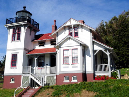
1874 (Paul J. Pelz). Inactive since 1942. 30 ft (9 m) square cylindrical wood tower rising from 2-story wood Italianate Victorian keeper's house. The active light (focal plane 120 ft (36.5 m); white flash every 10 s) is mounted on a 13 ft (4 m) pole. This lighthouse is a sibling of the East Brother Island Light (see Northern California) and the Hereford Inlet Light in New Jersey. The original lantern was removed in 1942 but a wood replica lantern was installed in 1974. In December 2006 Malibu realtor Louis T. Busch donated the original 4th order Fresnel lens to the society for display at the lighthouse. Building painted white with gray trim; lantern and gallery black. A 2023 photo is at right, Christopher Hyun has a 2020 photo, a 2022 photo is available, Tony Hoffarth has a photo, Lighthouse Digest has a July 2006 article on the lighthouse, Marinas.com has aerial photos, Michael Tuttle has a street view, and Google has a satellite view. Saved from demolition in 1972 and refurbished in 1972-74 by local preservationists, the lighthouse was then used for many years as the park superintendent's residence. In 2002 a $2.6 million project accomplished a complete restoration of the lighthouse. A chapter of the U.S. Lighthouse Society, the Point Fermin Lighthouse Society , supports the lighthouse and has opened it to visitors. In 2012 the lighthouse became available for transfer under NHLPA. The City of Los Angeles and three nonprofit organizations applied for ownership and in January 2015 ownership was awarded to the city. After various delays ownership was tranferred formally in December 2018. Located on Paseo del Mar at the foot of Gaffey Street in San Pedro. Site open, lighthouse and tower open in the afternoon every day except Mondays, certain major holidays, and when there are special events in the park; guided tours are available. Owner: City of Los Angeles. Site manager: Department of Recreation and Parks (Point Fermin Park). . ARLHS USA-621. Active light: Admiralty G3794; USCG 6-0140.

Point Fermin Light, San Pedro, June 2023
Instagram photo by Point Fermin Lighthouse

Los Angeles County: Rancho Palos Verde Lighthouse
* Point Vicente
1926. Active; focal plane 185 ft (56 m); two white flashes every 20 s, separated by 5 s. 67 ft (20 m) cylindrical reinforced concrete tower, painted white. The original Barbier, Bernard and Turenne 3rd order Fresnel lens (1886) is on display at the Point Vicente Interpretive Center near the lighthouse. The 2-story concrete Spanish revival keeper's house houses a small museum; additional buildings were formerly used as Coast Guard housing. This is a very well preserved light station; members of the Coast Guard Auxiliary volunteer to maintain it. Tony Hoffarth's photo is at the top of this page, Steven Truong has a 2009 closeup, Yauheni Chudzilouski has a photo of the station, Marinas.com has aerial photos, Danny Valadez has a street view, and Google has a satellite view. The light station was well maintained for many years but Anderson reports that it has deteriorated in recent years. The site is popular for whale watching. Located on a cliff overlooking the Pacific on Palos Verdes Drive in Rancho Palos Verdes. Site open only to tours led by the Coast Guard Auxilary on the second Saturday of each month; tower closed. The lighthouse can be viewed any time from nearby. Owner/site manager: U.S. Coast Guard (Point Vicente Lighthouse). . ARLHS USA-640; Admiralty G3886; USCG 6-0170.

Ventura County Lighthouses
* Anacapa Island (2)
1932 (station established 1912). Active; focal plane 277 ft (84.5 m); two white flashes every 60 s, separated by 15 s. 55 ft (17 m) cylindrical reinforced concrete tower. Fog horn (blast every 15 s). The original 3rd order Fresnel lens is on display at the East Anacapa Visitor Center, housed in one of the light station's service buildings. This lighthouse is a shorter sibling of Point Vicente Light (previous entry). 1-story Spanish revival keeper's house (1932), assistant keeper's house, and fog signal building. Stephen Conn's photo is at right, Craig Baker has a 2019 photo, James Harrell has posted a virtual tour of the island including the lighthouse, Lighthouse Digest has an article by former crew member James W. Baker, and Google has a street view and a satellite view. Located on the eastern tip of the island about 15 miles (25 km) south southwest of Ventura. Anacapa is accessible by passenger ferry from Ventura. Site open, tower closed (visitors are not allowed near the lighthouse because of the continuously sounding fog signal). Owner: U.S. National Park Service. Site manager: Channel Islands National Park. . ARLHS USA-012; Admiralty G3940; USCG 6-0185.

Anacapa Island Light, Channel Islands National Park, August 2012
Flickr Creative Commons photo by J. Stephen Conn
* Point Hueneme (Port Hueneme) (2)
1941 (station established 1874). Active; focal plane 52 ft (16 m); white flash every 5 s, except every sixth flash omitted. 48 ft (15 m) square cylindrical art moderne concrete tower mounted on concrete fog signal building. Building is unpainted white concrete; lantern and window woods are painted bright red. The historic 4th order Fresnel lens (1899, transferred from the earlier tower) was removed in late 2013 or early 2014 and is now displayed on the first floor of the building. Fog horn (blast every 30 s) activated on radio request. Rennett Stowe's photo is at right, English has a photo, Arturo Jacoby has a 2019 photo, Brianna Driscoll has a 2017 closeup, Alec Garcia has a street view, and Google has a good satellite view. The name Hueneme is pronounced "Why-nee-mee". The earlier lighthouse (1874) was a copy of Point Fermin Light (see above); the Coast Guard has a historic photo and Huelse has a historic postcard view. The present lighthouse was restored by the Coast Guard in 1999. In July 2002 volunteers from the Coast Guard Auxiliary began offering tours. In November 2012 the Coast Guard and the Port Hueneme Cultural Heritage Board reached agreement on a plan to replace the Fresnel lens with a modern LED light; the lens was restored for display. Located in a city equipment yard on the east side of the harbor entrance at Port Hueneme about 5 miles (8 km) south of Oxnard. The area is accessible by a walking path from the Hueneme fishing pier parking area at Surfside Drive and Ventura Road; the walk to the lighthouse is about 1 mi (1.6 km) round trip. The city has a page for the walkway and lighthouse. Site open, tower closed; tours on the third Saturday of each month were suspended by the pandemic in 2020 and apparently they have not resumed. Owner/site manager: U.S. Coast Guard. . ARLHS USA-623; Admiralty G3926; USCG 6-0190.

Santa Barbara County Lighthouses
Santa Rosa Island South Point
Date unknown. Active; focal plane 530 ft (162 m); white flash every 6 s. Light mounted on a 1-story white equipment shelter. No photo available but Google has a satellite view. Santa Rosa is the second largest of the Channel Islands. Located on a ridge at the south point of the island. Site status unknown. Owner: U.S. Coast Guard. Site manager: U.S. National Park Service (Channel Islands National Park). Admiralty G3948; USCG 6-2755.

Point Hueneme Light, Oxnard, May 2009
Flickr Creative Commons photo by Rennett Stowe
 
Santa Barbara (3)
1935 (station established 1856). Active; focal plane 142 ft (43 m); white flash every 10 s. 24 ft (7 m) square pyramidal white concrete tower without lantern. The aerobeacon lens used here from 1935 to 1977 is on display at the Point Vicente Interpretive Center in Rancho Palos Verdes (see above). Matthew Cohen has a closeup photo, another closeup is available, Marinas.com has aerial photos, and Google has a satellite view. The Coast Guard has a photo of the original lighthouse, similar in design to the Old Point Loma Light; it was demolished after being heavily damaged in the earthquake of 29 June 1929. The modern light stands on the original site, adjacent to La Mesa Park. Located on Meigs Drive two blocks south of CA 225 in Santa Barbara. Site and tower closed. Owner/site manager: U.S. Coast Guard. ARLHS USA-736; Admiralty G3952; USCG 6-0195.
Point Conception (2)
1882 (station established 1856). Active; focal plane 133 ft (40.5 m); white flash every 30 s. 52 ft (16 m) stucco-clad brick tower attached to a 1-story brick fog signal building. Building painted white; roofs red. Fog horn (blast every 30 s). 1-story Spanish style stucco keeper's house (1911), oil house (1907), and modern buildings. Gilbert Arreola's photo is at right, Evan Rapoport has a November 2017 photo, a 2018 photo is available, Lighthouse Digest has Richard Clayton's 2000 article with excellent photos, and Google has a satellite view. One of the earliest California light stations. The original 1st order Fresnel lens (1856, transferred from the earlier tower) was removed in June 2013; after restoration it was placed on display at the Santa Barbara Maritime Museum. The lighthouse is probabkly endangered by its isolation and inadequate maintenance. In December 2017 the Nature Conservancy paid $165 million to purchase the 24,364 acre (9860 hectare) Cojo Jalama Ranches surrounding the light station. Located on the point marking the western entrance to the Santa Barbara Channel about 15 miles (25 km) south of Lompoc, surrounded by the Conservancy's new Jack and Laura Dangermond Preserve. Site and tower closed. Owner/site manager: U.S. Coast Guard. ARLHS USA-620; Admiralty G3964; USCG 6-0200.
[Point Arguello (4)]
1967 (station established 1901). Active; focal plane 100 ft (30.5 m); white flash every 15 s. 20 ft (6 m) post with gallery but no lantern; aerobeacon. Google has a satellite view. The NOAA National Data Buoy Center operates an automated weather station on the site. The original lighthouse had a square cylindrical tower attached to a 1-story keeper's house. It lasted only a decade. In 1911 it was replaced by a detached square tower. It was then replaced in 1934 by a square pyramidal skeletal tower, which was in turn replaced by the present post light. Located on the point, a very sharp promontory just off the coast road. Site and tower closed. Owner: U.S. Coast Guard. Site manager: U.S. Space Force (Vandenberg Space Force Base). ARLHS USA-612; Admiralty G3968; USCG 6-0210.

Point Conception Light, Lompoc, April 2021
Google Maps photo by Gilbert Arreola

San Luis Obispo County Lighthouses
** San Luis Obispo (Port Harford, Point San Luis) (1)
1890. Inactive since 1975. 40 ft (12 m) square cylindrical wood tower attached to a 2-story Victorian wood keeper's house. The original 4th order Fresnel lens is on display at the San Luis Obispo County Library. Original wood fog signal building, oil house, and other light station buildings. The original keeper's house was replaced with a modern house in 1961. A 2022 photo appears at right, Anderson also has a nice page on the lighthouse, Chris McKiernan has a 2022 photo, Lee Anna O'Daniel has a 2021 closeup, Marinas.com has aerial photos, Joel Atwater has a street view, and Google has a closeup street view and a satellite view. Ownership of the station was transferred to the Port San Luis Harbor District in 1992. The Point San Luis Lighthouse Keepers was formed to work for restoration of the light station. In 2003 all the structures were painted and parts of the lighthouse were restored and furnished with period antiques. In January 2006 Pacific Gas and Electric, which controls access, signed an agreement to provide $1.5 million to make the light station more accessible, including funds for a shuttle service to the site. The 1960s-era assistant keepers house was renovated as a maritime museum and a trolley was acquired to serve as the shuttle. In early 2012 the Lighthouse Keepers office moved to the newly-restored duplex assistant keeper's house. In 2015 a new boardwalk was installed to allow handicapped access to the keeper's house. Located on the western side of Point San Luis about 3 miles (5 km) southwest of Avila Beach, surrounded by Pacific Gas and Electric's Diablo Canyon nuclear power plant reservation. Accessible by the Pecho Coast hiking trail, which is open only to group hikes led by PG&E docents. The site is open to guided tours only, tower closed. Tours are available every Wednesday and Saturday, year round; reservations required. Access is by the trolley or by docent-led hikes from Avila Harbor on the Pecho Coast Trail. Owner: Port San Luis Harbor District; Site manager: Port San Luis Lighthouse . ARLHS USA-720.

San Luis Obispo Light, January 2022
Wikimedia Creative Commons photo by Glenda and Ken
* San Luis Obispo (2)
Date unknown. Active; focal plane 116 ft (35 m); white flash every 5 s, day and night. 6 m (20 ft) post attached to a 1-story equipment building. Joyce Cory has a 2022 photo and Google has a street view and a satellite view. Located in front of the historic lighthouse. Site open to guided tours only, tower closed. Admiralty G3972; USCG 6-0225
** Piedras Blancas
1879. Active; focal plane 142 ft (43 m); white flash every 10 s. 74 ft (22.5 m) brick tower (originally 115 ft (35 m)), painted white; The lantern and the top of the tower were removed after being damaged by an earthquake on New Years Eve 1948 and a storm in 1949; the light is displayed from the top of the capped tower. The original 1st order Fresnel lens was restored by the Lions Club of Cambria; since 1996 it has been displayed on Main Street across from the public library in Cambria by the Friends of Piedras Blancas Lighthouse. The historic principal keeper's house (1906) was relocated in 1960 to 270 Chatham Street in Cambria; formerly used as a private residence, it has been renovated and is now available for overnight accommodations. The brick fog signal building (1906), oil house, and several modern light station buildings remain near the lighthouse. A U.S. Geological Survey biological research station and a sanctuary for elephant seals are located adjacent to the lighthouse. Danielle Lortie Muller's photo at right, Anderson has an excellent page for the lighthouse, Stacy Cobb has a 2021 photo, English has a closeup photo, Marinas.com has aerial photos, Jake Schmit has a street view, and Google has a satellite view. Lighthouse Digest has Carole Adams's article on the history of the lighthouse, the Coast Guard has a historic photo showing the original form of the tower, and Huelse has a postcard view. Google also has a street view and a satellite view of the keeper's house, plus a street view and a satellite view of the lens building. In 1999 the rotating DCB-224 aerobeacon atop the tower failed. Unable to figure out how to repair it, the Coast Guard replaced it with a dimmer fixed lamp, leading to protests from preservationists. These protests led in 2002 to the installation of a VRB-25 beacon. In October 2001 the lighthouse was transferred from the Coast Guard to the Bureau of Land Management. BLM began planning to reconstruct the upper portion of the tower and the lantern and also began monthly guided tours under a cooperative arrangement with California State Parks. The Piedras Blancas Light Station Association was formed to manage tours and support the restoration effort. A final management plan, necessary before any restoration can be started, was published in late 2007. In 2008 the lighthouse and its surroundings were designated an Outstanding Natural Area. In 2011-12 a $750,000 project restored the lighthouse and oil house. A second phase of the restoration will include replacement of the lantern. In 2013 a replica of the historic water tower was completed; funds came partly from the California Highway Patrol, which installed concealed communications equipment inside the tanks. In 2015 funds were being sought to rebuild the station's historic entrance gate as a memorial to the late park manager Jim Boucher. In January 2017 President Obama expanded the boundaries of the California Coastal National Monument to include the light station. The Fresnel lens in Cambria was cleaned and restored in the winter of 2018-19. In November 2020 the Coast Guard reasserted ownership of the Fresnel lens and announced that custody would be transferred from the Lions Club to BLM. So far there's continued uncertainty on the future of the lens. In May 2022 fencing was placed around the enclosure due to concerns that the structure ws deteriorating. Located off CA 1 northwest of San Simeon. Site and tower closed except for guided tours (reservations required) leaving from the old Piedras Blancas Motel 1.5 mi (2.5 km) north on highway 1. Tours are available at 9:45 am on Tuesday, Thursday, and Saturday year round, federal holidays excepted, and daily except Sunday and Wednesday June 15 through August 31. Reservations are not needed except for large groups. Owner/site manager: U.S. Bureau of Land Management (Piedras Blancas Light Station ). ARLHS USA-598; Admiralty G3982; USCG 6-0265.

Piedras Blancas Light, San Simeon, March 2014
Instagram photo by Danielle Lortie Muller

Inland Southern California Lighthouses

Riverside County: Canyon Lake Lighthouse
Canyon Lake
1968. Active; focal plane 20 ft (6 m); flashing white light. 23 ft (7 m) round tower with lantern and gallery. Lighthouse painted white; the lantern was formerly red but is now painted blue. Jim Sneddon has a 2008 photo and Google has a satellite view. The lighthouse was built by the Corona Land Company as part of the original development of Canyon Lake, after the company's president, Gordon Heath, was inspired by the Brant Point Light on a visit to Nantucket, Massachusetts. In April 2016 engineers determined that the lighthouse was deteriorating and recommended that it be moved onshore for repairs. It was later returned to the water. The blue lantern was installed in 2018 and in 2021 the lighthouse was raised on a new concrete foundation. Located on a small artificial island at the junction of the northern and eastern branches of the lake, in Riverside County about 8 km (5 mi) west of Lake Elsinore. Site access unknown (gated community). Owner/site manager: City of Canyon Lake.

San Bernardino County: Lake Havasu Lighthouses (see also Arizona)
Lake Havasu is the reservoir on the Colorado River pooled behind Parker Dam, completed in 1938.The river forms the border between southern California and Arizona. The lake, a major water source for both states, is about 30 miles (50 km) long. Lake Havasu City, founded in 1964, is built on the east (Arizona) side of the lake. Members of the Lake Havasu Lighthouse Club have been building a series of lighthouses on the lake. These lights are reduced-size replicas inspired by famous lighthouses of the U.S. and Canada. The lights are legitimate aids to navigation, with designs approved by the Coast Guard and locations approved by the states as part of a master plan for lighting the waterways of the lake. As of 2018 a total of 28 lighthouses have been completed, seven on the California side of the lake and 21 on the Arizona side. The Lake Havasu City Convention and Visitors Bureau has a page that includes a map of the lighthouse locations.
* Havasu Landing (Table Bluff Replica)
2006. Active; amber flash every 1 s. Approx. 20 ft (6 m) square cylindrical tower with lantern and gallery. Lighthouse painted white with gray trim to resemble the Table Bluff Light (see Northern California); lantern roof is red. Kevin Myers's photo is at right, another photo is available, and Google has a satellite view. This was the first of the Lake Havasu lighthouses to be built on the California side of the lake. Located on the breakwater on the north side of the entrance to the Havasu Landing Marina in Havasu Lake. Site open, tower closed. Site manager: Havasu Landing Resort and Casino.
Havasu West (Angels Gate replica)
2020. Active; green flash every 1 s. Approx. 25 ft (7.5 m) round tower with lanetrn and gallery rising from an octagonal base. Lighthouse painted white with black trim, lantern and gallery black. A closeup photo is available and Google has a satellite view. The original lighthouse stands in Los Angeles harbor (see above). Located on a promontory directly opposite the west end of Havasu Island. Site status unknown.
Grass Island (Mount Desert Rock Replica)
2007. Active; green flash every 1 s. Approx. 20 ft (6 m) round concrete block tower with lantern and gallery. The tower is unpainted gray concrete; lantern painted black. Lake Havasu City (Arizona) has posted a closeup photo and Google has a satellite view. The original Mount Desert Rock Light is on a small island off the coast of Maine. Located on Grass Island, just off the California side of the lake south of Havasu Island. Accessible only by boat. Site open, tower closed.
Copper Canyon North (Pemaquid Point Replica)
2017. Active; flash every 1 s, color not specified. Approx. 20 ft (6 m) round aluminum tower with lantern and gallery. The Lighthouse Club has a small photo (fourth row, left end) and Google has a satellite view. Located on an island about 0.6 mi (1 mi) northwest of Copper Canyon. Accessible only by boat. Site open, tower closed.
Copper Canyon (Pigeon Point Replica)
2016. Active; green flash every 1 s. Approx. 20 ft (6 m) round concrete block tower with lantern and gallery. Lighthouse painted white with black trim to resemble the Pigeon Point Light (see Northern California). Google has a satellite view. Located at the tip of a promontory on the west side of the lake north of the Copper Canyon narrows. Site open, tower closed.

Havasu Landing Light, Havasu Landing, May 2013
ex-Google Plus photo by Kevin Myers
Copper Canyon South (Umpqua River Replica)
2009. Active; green flash every 1 s. Approx. 26 ft (8 m) round concrete block tower with lantern and gallery. Lighthouse painted white, lantern roof red. Google has a satellite view. The original lighthouse is on the southern coast of Oregon. This is one of the more ambitious projects of the Lake Havasu Lighthouse Club. Located on a steep slope south of Copper Canyon, about 3 miles (5 km) southeast of Havasu Island, marking a significant narrowing of the lake. Accessible only by boat. Site open, tower closed.
Whipple Bay (Grays Harbor Replica)
2013. Active; green flash every 1 s. Approx. 23 ft (7 m) octagonal tower with lantern and gallery. Lighthouse painted white with a black top. Google has a satellite view. The original lighthouse is at Grays Harbor, Washington. Located on a promontory on the east side of the entrance to Whipple Bay, a protected harbor on the lower section of the lake. Accessible only by boat. Site open, tower closed.

Information available on lost lighthouses:

Notable faux lighthouses:

Adjoining pages: North: Northern California | East: Arizona | South: Northwestern Baja California

Return to the Lighthouse Directory index | Ratings key

Posted May 2005. Checked and revised December 24, 2023. Lighthouses: 37. Site copyright 2023 Russ Rowlett and the University of North Carolina at Chapel Hill.