Lighthouses of Bulgaria

The Republic of Bulgaria is a nation of southeastern Europe bordering Romania to the north, Turkey to the southeast, and Greece to the south. As an empire founded in 681 it ruled a large part of the Balkans for centuries before falling under the rule of the Ottoman Empire around 1400. It became an independent nation again in 1878 but the southeastern part of the country, including the Burgas area, remained nominally in the Empire under the name Eastern Rumelia until 1886.

Bulgaria has about 200 km (125 mi) of coastline facing east on the Black Sea. The principal ports are Varna in the north and Burgas in the south. In recent years the country's Black Sea beaches have become popular vacation destinations for Eastern Europeans and the coastline has come to be called the Bulgarian Riviera.

Bulgaria is divided into 27 provinces (oblasti) and the provinces are subdivided into municipalites (obshtina).

The Cyrillic script, created in Bulgaria during 9th century, is used to write the Bulgarian language. The Bulgarian word for a lighthouse is far (фар). Nos (нос) is a cape, ostrov (остров) is an island, reka (река) is a river, and pristanishte (пристанище) is a port or harbor.

Since the end of the Communist era (1945-1991) a number of place names that had been changed under Communist rule have reverted to the original forms. The Communist era names are shown in braces {}.

Aids to navigation in Bulgaria are maintained by the Bulgarian Ports Infrastructure Company.

Special thanks to Javier Ortuño Garcia, who visited Bulgaria in 2019 and provided information and photos for this page.

ARLHS numbers are from the ARLHS World List of Lights. Admiralty numbers are from volume N of the Admiralty List of Lights & Fog Signals. U.S. NGA List numbers are from Publication 113.

General Sources
Фаровете по българското черноморие (Lights on the Bulgarian Black Sea)
Small photos of most Bulgarian lighthouses. Many are from a former page by Milan Asadurov.
Online List of Lights - Bulgaria
Photos by various photographers posted by Alexander Trabas. The photos for Bulgaria are by Eckhard Meyer and Capt. Peter Mosselberger ("Capt. Peter").
Lighthouses in Bulgaria
Photos by various photographers available from Wikimedia.
World of Lighthouses - Bulgaria
Photos available from Lightphotos.net.
Europäische Leuchttürme auf historischen Postkarten
Historic postcard images posted by Klaus Huelse.
Navionics Charts
Navigation chart information for Bulgaria.

St. Nicholas Light
St. Nicholas Light, Varna, September 2012
ex-Flickr photo copyright Peter Kostov
used by permission

Dobrich Province Lighthouses

Dobrich Province is a part of the region known as Southern Dobrudja. Historically part of Bulgaria, Southern Dobrudja was administered by Romania from 1913 to 1940.

Shabla Lighthouses
* Krapets (Kartolia)
1967. Inactive. 15.5 m (51 ft) square skeletal tower with gallery; lantern removed. Google has a street view and the shadow of the tower is seen in Google's satellite view. A twin of the Kamen Bryag lighthouse. Located on a promontory on the north side of Krapets, about 10 km (6 mi) south of the Romanian border. Site open; probably nothing prevents visitors from climbing the tower. ex-Admiralty E5017.
* Shabla (2)
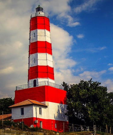
1856 (Ottoman; station established 1786). Active; focal plane 36 m (118 ft); three white flashes, in a 2+1 pattern, every 20 s. 32 m (105 ft) octagonal brick tower with lantern and gallery, mounted on a large 3-story square stone base; the tower is covered by metal panels. Entire lighthouse, including the base, painted with red and white horizontal bands. A 1- and 2-story keeper's house is attached to the base of the lighthouse. Mladen Marinov's photo is at right, Wikimedia has Plamen Agov's photo, Trabas has Meyer's excellent photo, Plamen Stoev has a photo, Denica Barfonchovska has another excellent closeup photo, Danny Rimpl has a nice 2008 photo, Wikimedia has several good photos, Bulgarian Wikipedia has a page for the lighthouse, and Google has a street view and a satellite view. Mladen Marinov's 2022 photo shows the lighthouse freshly repainted. This is Bulgaria's oldest, tallest, and best known lighthouse. It is a staffed station. Built by the Ottoman Empire, it stands on the easternmost point of the country. Located about 5 km (3 mi) east of the town of Shabla in the northeastern corner of Bulgaria. Site open, tower closed. ARLHS BUL-017; Admiralty N5016, NGA 17660.

Kavarna Lighthouses
* Kamen Bryag
1967. Inactive. Approx. 15 m (49 ft) square skeletal tower with gallery. Svilen K. Sotirov has a closeup photo, Google has a distant street view from the coastal highway, Bozhidar Todorov has a street view from atop the tower, and the shadow of the tower is centered in a Google satellite view. Located on a bluff about 1.5 km (1 mi) northeast of the village of Kamen Bryag. Site open; probably nothing prevents visitors from climbing the tower. ARLHS BUL-008.
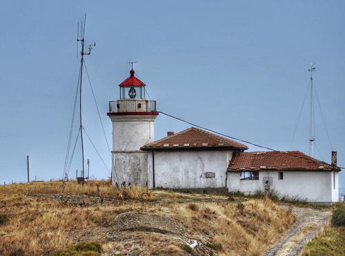
Kaliakra (Nos Kaliakra, Cape Kaliakra, Kaliakrenski) (2)
1901 (station established 1866). Active; focal plane 68 m (223 ft); white flash every 5 s. 10 m (33 ft) cylindrical stone tower with lantern and gallery, rising from the front of a 1-story keeper's house. 3rd order Fresnel lens in use. Lighthouse painted white. Trabas has Meyer's photo, a fine closeup is available, Lightphotos.net has a photo, Wikimedia has Spiridon Manoliu's aerial photo, and Google has an indistinct satellite view. Cape Kaliakra (the name means "beautiful headland" in Greek) is a razor-thin ridge that points southward into the Black Sea. The cape is a popular tourist attraction but visitors are not allowed to approach the lighthouse. Located about 20 km (13 mi) south of Shabla and 12 km (7.5 mi) southeast of Kavarna. Site and tower closed (military installation). ARLHS BUL-016; Admiralty N5012, NGA 17656.

Shabla Light, Shabla, July 2022
Google Maps photo by Mladen Marinov
* Kavarna Pierhead (2)
Date unknown. Active; focal plane 12 m (39 ft); white light, 2.5 s on, 2.5 s off. 8 m (26 ft) round hourglass-shaped white fiberglass tower painted white. Javier Ortuño Garcia's photo is at right, Vlad Popescu has a 2022 photo, Pirin Andreev has a closeup, and Google has a 2021 street view and a satellite view. Trabas has Meyer's closeup photo of the original light, another closeup is available, and Google has a distant 2012 street view from the beach. Located at the end of the east pier at Kavarna. Accessible by walking the pier. Site open, tower closed. Admiralty N5011, NGA 17652.

Balchik Lighthouses
Balchik Main
Date unknown. Inactive. 16 m (52 ft) square skeletal tower carrying radar and communications gear. Lightphotos.net has a closeup photo and Google has an indistinct satellite view. This light appears operational but it does not appear in the international lists and is not charted by Navionics. Its great height (focal plane 202 m (663 ft)) limits its navigational value. Located atop a steep slope on the east side of Balchik harbor. Site status unknown.
#Ekrene (Nos Ekrene)
1961. Inactive since 2005 and destroyed in 2012. 15 m (49 ft) square cylindrical masonry tower with lantern and gallery, rising from the front of a 1-story keeper's house. Lighthouse painted white. Two small photos are available (first two photos on the page) and Google has an indistinct satellite view of the area. The lighthouse was abandoned when creeping landslides threatened its foundation; a more serious landslide collapsed the lighthouse on 14 October 2012. Tourist sites described the lighthouse as a "famous" attraction but the lack of closeup photos suggests that it was rarely visited. Located on a bluff about 20 km (13 mi) northeast of Varna. Site open, tower closed. ARLHS BUL-005; ex-Admiralty E5009, ex-NGA 17644.

Kavarna Light, Kavarna, July 2019
photo copyright Javier Ortuño Garcia; used by permission

Varna Province Lighthouses

Varna Lighthouses
The third largest city in Bulgaria, Varna is a major port and the headquarters of the Bulgarian Navy. The city has a population of about 400,000.
Varna Evsinograd (Euxinograd, Yevksinogradski) Mole
1911. Active; focal plane 19 m (62 ft); continuous red light. 16 m (52 ft) round concrete tower with lantern and an octagonal gallery. Lighthouse painted white. Trabas has Capt. Peter's photo, Huelse has a historic postcard view, and Google has a satellite view and a distant street view. Javier Ortuño Garcia visited in 2019 and reports that the property is owned by the government as a retreat for the president and other officials. Located on the north side of Varna Bay about 5 km (3 mi) east northeast of the city's harbor. Site and tower closed but the lighthouse can be seen from nearby beaches. ARLHS BUL-006; Admiralty N5008.5, NGA 17640.
* Varna East Breakwater (Sveti Nikolaos, St. Nicholas) (1) (relocated)
1903. Inactive since 1986. 8 m (26 ft) round cylindrical cast iron tower with lantern and gallery, painted white; lantern dome painted black. Andrew Levey has a photo, David Collins has a good 2007 photo, and Google has a street view and a satellite view. This lighthouse, a typical prefabricated French tourelle, has been relocated to a park near the Varna Naval Museum and the Varna Aquarium. Huelse has a historic postcard view of the lighthouse on station. Site open, tower closed. ARLHS BUL-032.
* Varna East Breakwater (Sveti Nikolaos, St. Nicholas) (2)
1986 (station established 1903). Active; focal plane 17 m (56 ft); white flash every 10 s (?). 8 m (26 ft) round cylindrical tower with lantern and gallery, mounted on a square stone base. Lighthouse painted white. Peter Kostov's photo is at the top of this page, Trabas has Capt. Peter's photo, Felix Haller has a photo, Ivan Dimitrov has a 2019 photo, another good photo is available, Dimitar Krumov has a closeup street view, and Google has a satellite view. An image of St. Nicholas is mounted on the base of the lighthouse. (During the Communist era this image was replaced by an image of Georgi Dimitrov, the first Communist dictator of Bulgaria.) The original lighthouse was moved to a museum setting (previous entry). Javier Ortuño Garcia reports that the white light was continuous in 2019. Located at the end of the main breakwater of Varna harbor. Accessible by walking the pier. Site open, tower closed. ARLHS BUL-025; Admiralty N5004, NGA 17628.
* Varna East Breakwater Spur
1903. Active; focal plane 10 m (33 ft); green light, 2 s on, 2 s off. 6 m (20 ft) round cylindrical cast iron tower with lantern and gallery. Lighthouse painted white, lantern dome black. Trabas has Capt. Peter's photo (also seen at right), Lightphotos.net has a photo, Eva Kraskova has a 2023 photo, and Google has a street view and a satellite view. This lighthouse is another typical prefabricated French tourelle. Located on a short westward spur off the east (main) breakwater at Varna, marking (with the South Breakwater Light) the entrance to Varna's inner harbor. Accessible by walking the pier. Site open, tower closed. ARLHS BUL-023; Admiralty N5005, NGA 17633.


East Breakwater Spur Light, Varna
photo copyright Capt. Peter Mosselberger; used by permission

Varna South Breakwater
1903. Active; focal plane 10 m (33 ft); red light, 2 s on, 2 s off. 6 m (20 ft) round cylindrical cast iron tower with lantern and gallery. Lighthouse painted white, lantern red with a gold dome. Trabas has Capt. Peter's photo, Peter Petrov has a photo, Krasimir Dimitrov has a street view across the harbor from the East Breakwater, and Google has a satellite view. This lighthouse is a typical prefabricated French tourelle, identical to the East Breakwater Spur Light. Located at the end of a short pier on the west (mainland) side of Varna's inner harbor. Site status unknown. ARLHS BUL-024; Admiralty N5006, NGA 17632.
* Galata (Nos Galata) (2)
1913 (station established 1863). Inactive since 1987. 9 m (30 ft) round cast iron (?) tower with lantern and gallery, painted white. Trabas has Capt. Peter's photo showing both Galata lighthouses, Miroslav Minkov has a 2021 closeup of the tower, Svilen Enev has a distant view, Huelse has a historic postcard photo, Ivan Dimitrov has a street view, and both Nos Galata lighthouses can be seen in a Google satellite view. Another photo, no longer online, showed a Fresnel lens in the tower. During World War I the light station was damaged by shelling from the Russian cruiser Empress Maria, but it was repaired after the war. Nos Galata is a prominent cape at the south side of the entrance to Varna Bay, about 5 km (3 mi) southeast of the city. Site presumably open, tower closed. ARLHS BUL-030.
* Galata (Nos Galata) (3)
1987 (station established 1863). Active; focal plane 76 m (249 ft); three white flashes every 15 s. 22m (72 ft) octagonal tower with lantern room, rising from a 1-story administration building. The tower is white with beige vertical stripes. Nautophone fog signal (one short and two long blasts every 30 s). Javier Ortuño Garcia's photo is at right, Trabas has Capt. Peter's photo, a 2011 closeup is available, Rosen Iliev has a 2021 photo, and Google has a street view. Svilen Enev's photo of the cape shows both lighthouses and both can be seen in a Google satellite view. This light serves as the city's landfall light. Site open, tower closed. ARLHS BUL-015; Admiralty N5000, NGA 17624.

Dolni Chiflik Lighthouse
Reka Kamchia (Kamchia River)
1932. Inactive. 18 m (59 ft) square pyramidal skeletal tower carrying a slatted daymark colored in black and white horizontal bands. The lighthouse is to the right of the taller radar tower in Erik Vojtek's street view but it is partly hidden in trees in Google's satellite view. Located on a bluff above the north side of the mouth of the Kamchia River in the Dolni Chiflik municipality. Site status unknown.

1987 Nos Galata Light, Varna, July 2019
photo copyright Javier Ortuño Garcia; used by permission

Byala Lighthouse
Sveti Athanas (Nos Sveti Atanas, Byala)
1932. Inactive since 2015; charted as a landmark. Approx. 6 m (20 ft) round rubblestone tower. Paul Costea has a 2019 photo, another 2019 closeup photo is available, the lighthouse can be seen to the left of the radar tower in Andrey Belov-Kovalevsky's aerial photo of the cape, and Google has a satellite view. The lighthouse was extended in the 1980s by raising the light on a short skeletal tower, but that extension has been removed. Located on a hillside above a promontory at Byala (Bjala). Site open, tower closed. ARLHS BUL-004; ex-Admiralty N4998, ex-NGA 17616.

Burgas Province Lighthouses

Nesebar Lighthouses
* Emine (Nos Emine, Cape Emine)
1880. Active; focal plane 64 m (210 ft); white light, 1.5 s on, 4.5 s off. 9 m (30 ft) round masonry tower with lantern and gallery, attached to a 1-story keeper's house. Lighthouse painted white; lantern roof painted red. Javier Ortuño Garcia's photo is at right, Kiril Stanchev has a 2007 photo, a 2008 photo is available, Wikimedia has Evgeni Dinev's distant view showing the spectacular setting of the light station, Trabas has Meyer's distant view, and Google has a satellite view and a distant street view. Cape Emine is a prominent cape projecting into the Black Sea about 20 km (13 mi) northeast of Nessebur. The cape is the eastern end of the projected trans-European E3 footpath. The site appears accessible, but the light station itself is closed. ARLHS BUL-014; Admiralty N4996, NGA 17612.
[Nesebar (Nesebur, Nessebur) (3)]
1978 (station established 1932). Active; focal plane 10 m (33 ft); flash every 8 s, red or green depending on direction. 6 m (20 ft) square skeletal tower. Trabas has Meyer's distant view and Google has a street view, but the small tower is hard to see in Google's satellite view. Located at the end of the breakwater attached to the southwestern tip of the island. Site open, tower closed. Admiralty N4994, NGA 17608.

Pomorie Lighthouse
Pomorie Reef
1933. Active; focal plane 12 m (39 ft); three quick white flashes every 10 s. 8 m (26 ft) round cylindrical stone tower with gallery mounted on a square pier. Lighthouse painted black with one yellow horizontal band. Vlad Barbu has a photo, a distant view is available, Trabas has Meyer's distant view, and Bing has a satellite view. Pomorie is a beach town at the end of a narrow spit about 15 km (9 mi) east northeast of Burgas; the light marks the north side of the entrance to Burgas Bay. Located on a rock southeast of the beach at Pomorie. Accessible only by boat. Site and tower closed. ARLHS BUL-018; Admiralty N4990, NGA 17604.

Cape Emine Light, Emona, August 2019
photo copyright Javier Ortuño Garcia; used by permission

Burgas Lighthouses
A city of about 250,000 residents, Burgas is Bulgaria's largest port and the site of southeastern Europe's largest oil refinery. The city's harbor, Burgas Bay, is the westernmost extension of the Black Sea.

*
Burgas (East Breakwater) (2)
Date unknown (station established 1899). Active; focal plane 24 m (79 ft); white flash every 3 s. 14 m (46 ft) round cylindrical tower with lantern and gallery, painted with red and white horizontal bands; lantern painted white. Fog horn (one short and three long blasts every 30 s). Sergey Lugovskoy has a 2021 photo, Ivan Samardzhiev has a 2014 photo, Biser Boichev has a photo, Dobromir Anguelov has a drone view, Mihail Arnaudov has a street view, Trabas has Meyer's distant view, Konstantin Volodin has a street view, and Google has a satellite view. Huelse has a historic postcard view of the original lighthouse, a cast iron tourelle. Located at the end of a breakwater mole on the north side of the entrance to Burgas harbor. There is a road on the mole. Site open, tower closed. ARLHS BUL-002; Admiralty N4984, NGA 17580.
* Burgas East Breakwater Spur
Date unknown. Inactive. Approx. 7 m (23 ft) round barbell-shaped metal tower painted white with a green top. Vilin Petrov has a 2017 photo, Fiodor Kaloev has a 2021 street view, and Google has a satellite view. Located on a short spur near the end of the East Breakwater. Site appears open, tower closed.
* Burgas East Breakwater West Arm (2)
1899. Active; focal plane 10 m (33 ft); green light, 2 s on, 2 s off. 7 m (23 ft) round cast iron tower with lantern and gallery. Lighthouse painted white with a green lantern. Veselin Dobrev has a photo, Miro Boychev has a photo, Krassimir Ivanov has a closeup street view, and Google has a satellite view. Fiodor Kaloev has a 2021 street view showing the lighthouse being repainted. This is another typical tourelle. Located at the end of the inner breakwater on the east side of the entrance to the inner harbor of Burgas. Site appears open, tower closed. ARLHS BUL-026; Admiralty N4986, NGA 17584.
* Burgas West Breakwater East Arm (2)
1899. Active; focal plane 10 m (33 ft); red light, 2 s on, 2 s off. 7 m (23 ft) round cylindrical cast iron tower with lantern and gallery. Lighthouse painted white, lantern black. Milen Ivanov has a 2011 photo, Fiodor Kaloev has a distant 2021 street view, and Google has a satellite view. Located at the end of the inner breakwater on the west side of the entrance to the inner harbor of Burgas. Site appears open, tower closed. ARLHS BUL-027; Admiralty N4988, NGA 17588.
Burgas South Breakwater
Date unknown. Active; focal plane 11 m (36 ft); white flash every 4 s. 9 m (30 ft) post with an expanded lantern structure. No photo available but Google has a satellite view. Dobromir Anguelov has an indistinct and very distant drone view. Located at the end of the main breakwater for the southern (newer) harbor of Burgas. Site status unknown. Admiralty N4983.5, NGA 17582.
* Sveta Anastasiya {Ostrov Bolshevik}
1914 (station established 1863). Active; focal plane 22 m (72 ft); white or red light, depending on direction, 2 s on, 6 s off. 12 m (39 ft) round tower with lantern and gallery. Lighthouse painted white; lantern dome is gray metallic. 1-story keeper's house, painted white with a red tile roof. A photo is at right, George Iliev has a closeup street view, Sergei Artemenko has a 2022 photo, Dmitry Batalov has a view from the sea, Lightphotos.net also has a view from the sea, Krasim Kostadinov has a street view, and Google has a satellite view. This lighthouse is a sibling of the original Nos Galata lighthouse (see above). Sveta Anasastiya is a small island in Burgas Bay about 6 km (3.5 mi) east southeast of the Burgas waterfront. The island was the site of a convent, later converted to a prison. It is accessible by passenger ferry from Burgas. Site open, tower closed. ARLHS BUL-021; Admiralty N4980, NGA 17572.
Sveta Anastasia Light
Sveta Anastasiya Light, Burgas, August 2014
Wikimedia public domain photo by Skirienko

Sozopol Lighthouses
* Sveti Ivan
1884. Active; focal plane 44 m (144 ft); two white flashes every 10 s. 13 m (43 ft) round concrete tower with lantern and gallery, attached to a small equipment cabinet. A keeper's house is nearby. Lighthouse painted white; lantern dome is gray metallic. Fog horn (4 blasts every 30 s). Borislav Vassilev has a 2006 closeup photo (also seen at right), Trabas has Meyer's view, Geir Halvorsen has a distant view, Martin Kirilov has a drone view, and Google has a satellite view of the station. The lighthouse was built by French engineers for the government of Eastern Rumelia, an autonomous Ottoman province. Sveti Ivan (St. John) is an island about 1.2 km (3/4 mi) north of Sozopol on the south side of the entrance to Bourgaski Zaliv (Burgas Bay). The island is famous for the ruins of a 12th century monastery, and archaeologists have found the ruins of a second century Roman lighthouse on the island. Boat transportation is available from Sozopol. Located on the northern tip of the island. Site open, tower closed. ARLHS BUL-022; Admiralty N4976, NGA 17564.
* Agios Petros South Pier
Date unknown. Active; focal plane 6 m (20 ft); green light, 2 s on, 2 s off. 5 m (17 ft) square 1-story white concrete tower with gallery. Trabas has Meyer's photo, another photo is available, and Google has an indistinct satellite view. Located at the end of the south (really west) quay at Sozopol harbor. Accessible by walking the pier. Site open, tower closed. ARLHS BUL-036; Admiralty N4978.4.
* Sozopol (1)
1932. Inactive. 7 m (23 ft) short square skeletal tower centered on a 1-story square stone castellated building. The building is painted white with a black horizontal band. This structure is at the right in Meyer's photo, and Google has a satellite view. Located at an elbow of the North Pier at Sozopol. Accessible by walking the mole. Site open, tower closed. ARLHS BUL-034.
* Sozopol (2) (Agios Petros North Pier)
Date unknown. Inactive since 2019. 5 m (17 ft) square 1-story white concrete tower with gallery. Trabas has Meyer's photo, another photo is available, and Google has a satellite view. The pier is connected to a peninsula that was formerly the site of a naval college but is now designated as the site of a hotel. Located at the end of the north (breakwater) mole protecting the harbor at Sozopol. Accessible by walking the mole. Site open, tower closed. ARLHS BUL-035; ex-Admiralty N4978.3.

Sveti Ivan Light, Sozopol, July 2006
Google Maps photo by Borislav Vassilev
Maslen Nos (Cape Zeitin)
1930. Active; focal plane 37.5 m (123 ft); three white flashes every 17.2 s. 7 m (23 ft) stone tower with lantern and gallery, painted white. A 1-story building nearby is presumably a keeper's house. Boris Sinekeliev has a closeup photo, Vladislav Rusinov has a distant view, the tower peeks over the roof of the keeper's house in Emil Borisov's photo, and Google has a satellite view of the station. Located on a rocky promontory about 7 km (4.5 mi) northeast of Primorsko. Site status unknown. ARLHS BUL-010; Admiralty N4974, NGA 17556.

Primorsko Lighthouse
* Primorsko Pierhead
Date unknown (1930s). Active; focal plane 8 m (26 ft); white light, 2 s on, 3 s off. 5.5 m (18 ft) round stone tower with gallery; the light is displayed from a short skeletal mounting. Tower painted white. Trabas has Meyer's photo, another photo is available, and Google has a street view and a satellite view. Located at the end of the breakwater pier in Primorsko. Accessible by walking the pier (caution: no railings). Site open, tower closed. ARLHS BUL-019; Admiralty N4972, NGA 17552.

Tsarevo Lighthouses
* Tsarevo Breakwater (East Mole)
1936. Active; focal plane 12 m (39 ft); green light, 2 s on, 2 s off. 10 m (33 ft) round stone tower; the light was formerly displayed from a short skeletal tower atop the stone tower; Trabas has Meyer's photo. In or before 2017 the skeletal tower was replaced by a tall statue, as seen in Alexey Korobov's July 2017 photo and Pavla Minaříková's 2019 photo. Google has an indistinct satellite view. Located at the end of Tsarevo's main breakwater. Accessible by walking the pier. Site open, tower closed. Admiralty N4971, NGA 17548.
* Tsarevo {Micurin} Main
Date unknown (probably recent). Inactive since 2005. Light mounted atop a 20 m (66 ft) building, listed by NGA as a "dwelling." No photo available. Google has a street view of a building that is a likely location for the former light. Google has a satellite view of this location. Site presumably open. ARLHS BUL-012; ex-Admiralty N4971.5, ex-NGA 17550.
Tsarevo {Micurin} (2)
Around 2014 (station established 1932). Active; focal plane about 12 m (39 ft); light characteristic unknown. 12 m (39 ft) mast on a conical stone tower mounted on a square stone pier. Angel Ivanov has a 2015 photo, Rosen Drangov has a drone view, and Google has an indistinct satellite view. Trabas has Meyer's photo of the earlier light; it had been removed prior to Google's 2012 street view. Located on a reef off Tsarevo harbor. Accessible only by boat. Site open, tower closed. ARLHS BUL-031; Admiralty N4969, NGA 17544.
* Ahtopol (Akhtopol)
1932. Active; focal plane 15 m (49 ft); six quick white flashes followed by one long white flash every 15 s. 11 m (36 ft) tower in two sections: the lower section is a 6 m (20 ft) round stone rubblestone tower on a square rubblestone base, and the upper section is a 5 m (17 ft) square pyramidal cast iron (?) skeletal tower mounted on a small equipment shelter. Originally, the upper section was painted yellow and the lower section black, but in the summer of 2009 the light was restored and painted all white, as seen in Stefan Vatev's photo at right. Trabas has Meyer's photo, another view shows how close the light is to the waterfront of the town, and Google has a street view and a satellite view. The skeletal extension was added in 1936. Located on a rock just off the coast at Ahtopol, about 12 km (7.5 mi) southeast of Tsarevo. It appears that the lighthouse can be approached at low water. Site open, tower closed. ARLHS BUL-001; Admiralty N4968, NGA 17540.
Ahtopol Light
Ahtopol Light, Ahtopol, August 2009
Flickr Creative Commons photo by Stefan Vatev (no longer online)

Information available on lost lighthouses:

Notable faux lighthouses:

Adjoining pages: North: Romania | South: European Turkey

Return to the Lighthouse Directory index | Ratings key

Created January 12, 2007. Checked and revised September 26, 2023. Lighthouses: 32. Site copyright 2023 Russ Rowlett and the University of North Carolina at Chapel Hill.